

psuhoffman
-
Posts
27,417 -
Joined
-
Last visited
Content Type
Profiles
Blogs
Forums
American Weather
Media Demo
Store
Gallery
Everything posted by psuhoffman
-

Late Feb/March Medium/Long Range Discussion
psuhoffman replied to WinterWxLuvr's topic in Mid Atlantic
I respectfully disagree. I saw some equally awful pattern setups with pac puke airmasses that we managed a snow because of nothing other than a lucky wave track before. 1997 was one. The difference imo was the crap airmasses used to be +5 instead of +8 or worse. As the torches get even warmer it’s getting harder to luck into a Snow from a lucky track in a bad pattern. Lately there is another even more depressing phenomenon of waves that take a good track in a decent or even good long wave pattern and rain because it’s still not cold enough. Yea those are the more alarming cases. The ones where we can definitely say “this should have been snow”. The other category of which that gfs storm would fall are storms where I say “in the past there was an outside chance that could have been snow maybe…but none of them seem to be anymore and it’s not even close anymore” and that’s also worth noting. But this is the kind of discussion that is topical and important to have. Maybe you’re right about that gfs storm. So the dialogue is important. Your pushback isn’t what got me heated. It was the various disingenuous passive aggressive attempts to stop the discussion from happening at all. -
Late Feb/March Medium/Long Range Discussion
psuhoffman replied to WinterWxLuvr's topic in Mid Atlantic
Meanwhile where is all the topical long range analysts in here that it was soooo important we stop my post about the gfs rainstorm being affected by warming? Funny. We just had to stop that. Because it wasn’t topical. It was derailing the discussion. And then Fing crickets. You guys are so transparent. -
What Went Wrong in Winter 23-24/Base State/Will It Ever Snow Again??
psuhoffman replied to WxUSAF's topic in Mid Atlantic
discussing how the fact it’s warmer is affecting storms is topical and belongs in here. But then 5 people complain and fill the thread with arguments about it. Then sarcastic posts like this pop up. And the purpose is to F up the thread so bad every time this topic comes up to force the MODS to step in and squash it. It’s not cute or clever. -
What Went Wrong in Winter 23-24/Base State/Will It Ever Snow Again??
psuhoffman replied to WxUSAF's topic in Mid Atlantic
All these people in higher elevation locations posting how their snow has been better than the majority of this region only proves my point more because the boundary layer is warming faster. Higher elevations are as of yet less affected by what I was talking about. -
What Went Wrong in Winter 23-24/Base State/Will It Ever Snow Again??
psuhoffman replied to WxUSAF's topic in Mid Atlantic
They know who they are, that’s why they bitch and moan whenever I say it! @CAPE Maybe I’m not trying to convince them. Maybe I’m just trying to throw indisputable irrevocable proof that they’re wrong in their face! And maybe they don’t like that which is why they throw a hissy fit to try to force the mods to shut down the conversation. They can’t argue the evidence so they try to stop it from being shown. They have the right to be ignorant. And I have the right to throw the proof they are wrong in their face! -
What Went Wrong in Winter 23-24/Base State/Will It Ever Snow Again??
psuhoffman replied to WxUSAF's topic in Mid Atlantic
It’s ok. Our debates are amicable. I hope you’re right and I’m wrong. Actually I do think we get more snow once the pdo flips. I just thing we’ve warmed too much to overcome a -pdo anymore. -
What Went Wrong in Winter 23-24/Base State/Will It Ever Snow Again??
psuhoffman replied to WxUSAF's topic in Mid Atlantic
You’re east of a ridge in a down sloping situation. I’m on top of the highest point in the region. I’m north of you. I’m northeast which matters because I can get into later developing storms. Miller Bs aren’t as bad here. Yea they aren’t NYC good but…You got like 3” from Jan 2005 my area got 7”. That may not seem huge but it happens over and over. Someone’s it is huge. Feb 1978 your area got 2” my area got 16”. Also I’m on the first ridge so with an east wind in a coastal the upslope enhancement is insane. And being northeast helps me with the downslope zone east of the blue ridge. With a SWFE you’re in the dead zone. By me those systems redevelop some. And my elevation helps me with every marginal surface temp situation. Lastly I don’t avg 20” more than you because you don’t avg 20”. You’re closer to 23” so I average like 17” more. -
What Went Wrong in Winter 23-24/Base State/Will It Ever Snow Again??
psuhoffman replied to WxUSAF's topic in Mid Atlantic
JFC you just proved my whole point -
What Went Wrong in Winter 23-24/Base State/Will It Ever Snow Again??
psuhoffman replied to WxUSAF's topic in Mid Atlantic
Yea I got 50” in 2021. So what. That isn’t even an anomaly here. I Avg 40”. Or I used too lol. That’s like DC getting 17” in a winter. It’s the same departure from avg! A 50” winter happens every few years here. That isn’t the same feat it is for DC or Baltimore when that’s a once a decade thing. I’ve had 7 below avg years around that and I’m currently in the longest stretch without an 8” snow here ever going back to 1942 when reliable records started in this area. And why are you trying to rope me into defending arguments I never even made. When did I say it hadn’t snowed at all recently? When did I say we’ve had no good winters at all recently. I’ve made 2 arguments lately. It’s snowing less partly because more marginal temp storms are rain now than in the past. And that it’s been the worst 8 years ever for snow. Nothing you’re saying refutes either of those arguments. -
What Went Wrong in Winter 23-24/Base State/Will It Ever Snow Again??
psuhoffman replied to WxUSAF's topic in Mid Atlantic
I don’t care that wasn’t my point. Don’t tell me what or how to talk about the weather. If you don’t like it too bad. Plenty of people say shit I don’t like on here and I don’t try to suppress it or squash their right to say it. I might argue the point but have never said “don’t talk about that”. If you can’t handle it put me on ignore and move on with your life like a grown ass adult and stop this childish passive aggressive attempt to stop conversations you don’t like. -
What Went Wrong in Winter 23-24/Base State/Will It Ever Snow Again??
psuhoffman replied to WxUSAF's topic in Mid Atlantic
2021 was good here locally because I got very lucky. I’d never say WE had a good winter. It was bad for 90% in here. 2022 was good for some but bad for 75% of the region. 2019 was good for a stripe down the middle through IAD and DCA but bad for Baltimore north and south of manassas. Again as a whole it’s been the least snowy 8 years ever so how are you taking the “it’s fine” side??? I didn’t complain,I made analysis of a specific storm and phenomenon. Which this weird anecdotal list of snowy years has nothing to do with. Name the snowstorm we got in any of those years that came in a warm pattern from a perfect track wave? All those storms had a decently cold airmass in place or coming as the wave passed. So this is a bait and switch argument anyways. I shouldn’t have fallen for it as long as I did. Pretty good at a specific location I’ll give you. He said “we” and good. Ugh. This is silly. It’s been the least snowy 8 years at all 3 of our regions official recording sites. How do you argue it’s been ok within that fact? -
What Went Wrong in Winter 23-24/Base State/Will It Ever Snow Again??
psuhoffman replied to WxUSAF's topic in Mid Atlantic
Doesn’t have to be an argument if @snowfan stops making this same BS complaint every time I make legit analysts about our climo. I don’t tell him to shut up every time he says something I disagree with, and he says plenty. I just move on. Or maybe I comment that I disagree. But I never ever ever tell anyone what to talk about. He can F off with that BS. -
What Went Wrong in Winter 23-24/Base State/Will It Ever Snow Again??
psuhoffman replied to WxUSAF's topic in Mid Atlantic
I’m replying to this “what winters have been good” stuff in the other thread. Sorry @WxUSAF whether I agree with every decision or not I should respect your wishes because you put in a lot of work to make this board operate and I apologize for being difficult. -
What Went Wrong in Winter 23-24/Base State/Will It Ever Snow Again??
psuhoffman replied to WxUSAF's topic in Mid Atlantic
The fact remains as a whole it’s been the worst 8 years in recorded history. So arguments “it’s been good or even ok” seem a bit outlandish. -
What Went Wrong in Winter 23-24/Base State/Will It Ever Snow Again??
psuhoffman replied to WxUSAF's topic in Mid Atlantic
Yes but that winter SUCKED anywhere not at 1000 feet in our region! And 2022 was good in a very small geographic part of our region. It was “ok” in a larger area but it was still below avg in about 75% of our region. I think categorizing either of those as a “good winter” is an extreme stretch. -
What Went Wrong in Winter 23-24/Base State/Will It Ever Snow Again??
psuhoffman replied to WxUSAF's topic in Mid Atlantic
@Ji I like you a lot…but the last 8 years have literally been the least snowy in our regions history! So you’re not going to gaslight me with a “it’s not been that bad” argument. -
What Went Wrong in Winter 23-24/Base State/Will It Ever Snow Again??
psuhoffman replied to WxUSAF's topic in Mid Atlantic
Plus you said “we” then used a year that by your own admission was only good in a small portion of the area. And 2019 frankly was only “good” in about half. I’ve only had one above avg winter in the last 8. -
What Went Wrong in Winter 23-24/Base State/Will It Ever Snow Again??
psuhoffman replied to WxUSAF's topic in Mid Atlantic
You said since 2014. Then you included 2014. I assume you meant 2019 not 2021 but you still came up 1 short even including 2014. -
Late Feb/March Medium/Long Range Discussion
psuhoffman replied to WinterWxLuvr's topic in Mid Atlantic
But it’s not even snow at 4000 feet in the mountains. If it was a sloppy mix that didn’t amount to much near the cities and a big snow NW…I could buy that. Everyone references 1998. But places NW of 95 actually got decent snow that winter from many of those storms. It’s a matter of degrees. It’s weird to see so many deep lows track off the coast and be rain just about everywhere as recently. That’s not normal. Most importantly my case isn’t based on this one storm. Everyone keeps trying to refute me with “this one storm could have been rain before too”. Yes. But my case is a preponderance of evidence. It’s been too many if these in a row. -
What Went Wrong in Winter 23-24/Base State/Will It Ever Snow Again??
psuhoffman replied to WxUSAF's topic in Mid Atlantic
Name the 5 good winters since 2014 -
What Went Wrong in Winter 23-24/Base State/Will It Ever Snow Again??
psuhoffman replied to WxUSAF's topic in Mid Atlantic
Every time it’s applicable to analyzing something. I didn’t do that not to use it. But let’s cut through the BS shall we. The really disingenuous thing with this tact is absolutely EVERYTHING in this thread is repetitive. We’ve had every possible pattern before. Every type of storm. Every time you discuss a snowstorm you don’t say this. Because it’s a new damn storm. But it’s the same type of storm as hundreds before. it’s the same analysis. The same analogs. And we discuss the history. We repeat the same things over and over. And no one says a god damn thing. When we post a snow forecast map that looks like 500 storms before you don’t say this BS. As long as we’re analyzing why it will snow it’s fine if we repeat the same stuff 100 times. No one has ever told anyone to shut up when they post a similar great looking map to 5000 before. But when I do the same exact thing with a fail and point out how it’s similar to other fails lately and analyze why and compare it to the past and hypothesize why its a fail (hint it’s been really fooking warm lately) then you break out this BS garbage nonsense to suppress a topic you just don’t like. It’s the same repetitive analysis as we do when it’s going to snow! You don’t actually care because it’s repetitive. Because you don’t say a damn thing when we’re repetitive about stuff you like. But that’s hard to win with so you try this BS instead as a passive end around to squash the topic when the real issue is you just dont like what Im saying. -
What Went Wrong in Winter 23-24/Base State/Will It Ever Snow Again??
psuhoffman replied to WxUSAF's topic in Mid Atlantic
You know who. And ya I know they will never be convinced. It will be 2050 and Baltimore won’t have had a warning event for 30 years and they will still be saying “it’s just cyclical, we just can’t know, underwater volcanoes, aaaahhhhh, don’t talk about CC” because either it’s too depressing for them to admit OR their politics won’t allow them. But in a stubborn SOB! I couldn’t have lasted 17 years teaching HS in inner city Baltimore if I wasn’t. ETA: and I know you aren’t in those categories and my rant wasn’t even at you even though it was a reply to you, it’s that in fairness you give the head in the sand crew ammunition when you say stuff like “well the pattern isn’t actually good for snow”. Yea I know. But we used to and I guess I’m not ready to come to peace with the fact we can’t anymore, get snow in a bad pattern if we get lucky from a perfect wave track. -
What Went Wrong in Winter 23-24/Base State/Will It Ever Snow Again??
psuhoffman replied to WxUSAF's topic in Mid Atlantic
I didn’t even look at the run. It was a joke. But….and I promise this is the last time (at least in this thread) that I’ll say this…but several years ago when I did that case study of every Baltimore 4”+ snowstorm I was shocked how many actually featured a totally shit god awful pattern with reds and blues in all the wrong places with a pile airmass where it was 50 degrees the day before and the only thing that went right was somehow by some means the storm took a perfect track and so we got a 6” wet snow paste bomb storm. Obviously that wasn’t the majority of our storms and it’s not how we want to roll. I’m not saying we root for crap patterns. But it was enough of the storms that if we can’t ever get that kind of thing anymore, where it snows just because of a good track in an awful pattern, then it’s going to hurt us A Fooking Lot! Way more than some here want to admit! Just off the top of my head without even looking at the files… Our only real snow in 1997 came in a god awful pattern because we got lucky with a wave track. Look at this BS…we got a 4-8” snow from THIS BS on a stick pattern. 1976 would have been a completely snowless winter if not for a 10” wet snow storm that came in a pattern that had no business snowing in. There was another year in the early 90s where our only 2 significant snows both came in a pattern that had no business snowing. Yea it was a crap year but most had like 10-15” not NOTHING! You know what they all have in common. They’re a long ass time ago. It’s not happening anymore. There were a lot in the 50s, 60s, 70s, then they started to decline and they’ve gone extinct the last 10 years. Lately our bad patterns are so warm that it doesn’t matter what the track is. And every time I hear the same thing…but this wasn’t perfect. That wasn’t perfect. The high was too this or that. There was too much ridging in front. Yea no shit I know it can still snow if every fucking thing goes perfect. Yea if we get a 980 low off VA beach with a 1040 high over Montreal and a -3stdv block with a -epo arctic air mass yes we will get a shit ton of snow. But that’s going to happen once a decade. What about the rest of the god damn time? We had so many bad but not awful winters in the past where if you take away a couple snows that came from pure luck in a shit pattern they are suddenly a 3” snow year instead of 12” or absolutely nothing instead of 10” like 1976! lastly I know it’s impossible to prove what storms would or wouldn’t have been a snow 30 years ago. Not without tools I don’t have access too. There were perfect track rains in the 50s too when it was just too warm for any track to overcome. But there were some snows too! So while I can’t prove anything because of any one storm…when it happens over and over and over and none of them seem to be snow outside the higher elevations anymore…the preponderance of evidence is damning.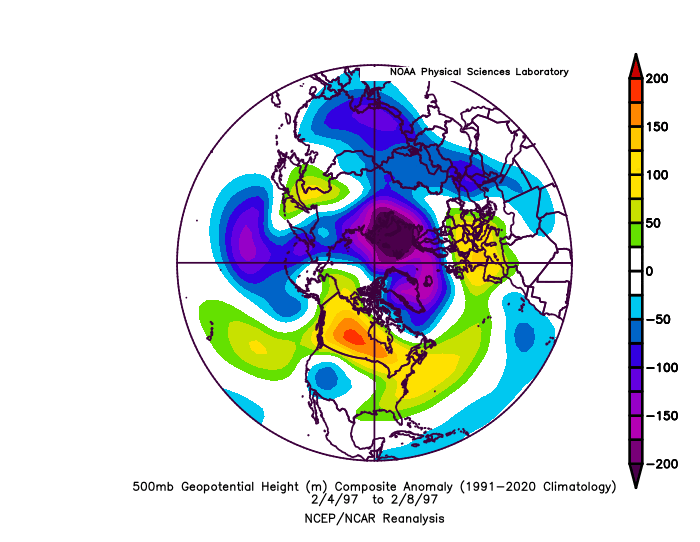
-
Late Feb/March Medium/Long Range Discussion
psuhoffman replied to WinterWxLuvr's topic in Mid Atlantic
another perfect track rainstorm is the perfect way to end this winter though -
Thunder snow!!! I mean it’s more like thunder slushbombs with some rain but I think for about 1 min it was enough slush to make it official. psuhoffman storm verified! lol
- 374 replies
-
- 11
-

-


