psuhoffman
-
Posts
27,419 -
Joined
-
Last visited
Content Type
Profiles
Blogs
Forums
American Weather
Media Demo
Store
Gallery
Everything posted by psuhoffman
-

Feb 22nd/23rd "There's no way..." Storm Thread
psuhoffman replied to Maestrobjwa's topic in Mid Atlantic
Just post some ensemble means eta I’m currently medicated for reasons I won’t go into so maybe I’m impaired BUT I stand by what I said even if the delivery is off -
Feb 22nd/23rd "There's no way..." Storm Thread
psuhoffman replied to Maestrobjwa's topic in Mid Atlantic
It’s the fooking GFS. I want a HECS as bad as everyone else but I give the gfs about as much credence as the JMA. It doesn’t even deserve play by play anymore. It’s not a major player anymore it’s just not. How many times has it failed in the last 2 years. Maybe not THIS bad but every fooking time we say “it can’t be this bad every time” Ya it is. We’d be better off ignoring it! I’m paying attention to the thing that might actually be real and is on all the better guidance. This isn’t to say there is 0 chance. Sure once in a blue moon some crazy freak solution can happen. There are a couple members within the better ensembles like that. It’s within the scope of what’s possible. But it’s a crazy long shot and I’m not getting excited until something better shows it. Until then I’m focused on the IVT which I think is real and they can sometimes put down a lot of snow. At least by our pittance standards. -
Feb 22nd/23rd "There's no way..." Storm Thread
psuhoffman replied to Maestrobjwa's topic in Mid Atlantic
This is another case where it’s showing degradation of snowfall we don’t even think about. The track of the 6z run reminded me a lot of a storm in the 60s that gave the Delmarva 20-28” but also have my area 20” and I was wondering why that run only had 10” here. Ya know how. I went back and looked at the coop data from the past storm. Delmarva got 24” from 2.5qpf. My area got 20” from 1.2 qpf. The gfs run was showing me getting 10” from 1.2qpf. Because it was so damn warm at the surface! 2 degrees colder (which is about what it was then) and it would have been 15-20” here from ratios! Usually further west makes up for less QPF with ratios but not if it’s 33 degrees! -
Feb 22nd/23rd "There's no way..." Storm Thread
psuhoffman replied to Maestrobjwa's topic in Mid Atlantic
I’m not a met but imo it’s a relatively delicate and not even that major of an interaction that have a huge impact down the road. Yea we notice it because we’re looking for it but if this interplay between those two SW wasn’t directly causing this dichotomy with a possible HECS we would never notice! If we simplify it it’s putting more energy into the lead wave in a two wave interaction and it’s a delicate balance where just enough tips the scale and you get a cascading effect later. That said it’s obviously still likely the GFS is the wrong one. However it does handle NS features a bit better. When it does rarely beat the euro it’s in situations like this. But I can’t remember a single example when it was totally all alone like this at this range and won. That said some stuff did make mini step towards it so I guess anything’s possible. But I wouldn’t bet anything I care about on it. -
Feb 22nd/23rd "There's no way..." Storm Thread
psuhoffman replied to Maestrobjwa's topic in Mid Atlantic
It always backs west. Thats how they can sometimes put down crazy totals. They form and slowly rotate west or stall and train. Westminsters biggest snow on record was an IVT. Lancaster area got a shock 13” from one in 2009 I think. They can be fun. Super rare down here. But once it ignites the IVT will slowly rotate west as the trough axis shifts in relation to the coastal low. Fujiwara! The issue is the axis was starting west of us and now it’s starting east. Ya it could stop. Hope it does. But I’ve seen these things do this up until game time. That 2009 one originally was supposed to be in VA. Then for a day about 48 hours out it looked like 6” here and I got excited and it ended up a Philly thing! Too many times I’ve seen these trend northeast. It’s a model bias. @CAPE @Terpeast I think you’ve both noticed this tendency also. Tell me I’m not crazy. Well I am, but not because is this. Plenty of other reasons. -
Feb 22nd/23rd "There's no way..." Storm Thread
psuhoffman replied to Maestrobjwa's topic in Mid Atlantic
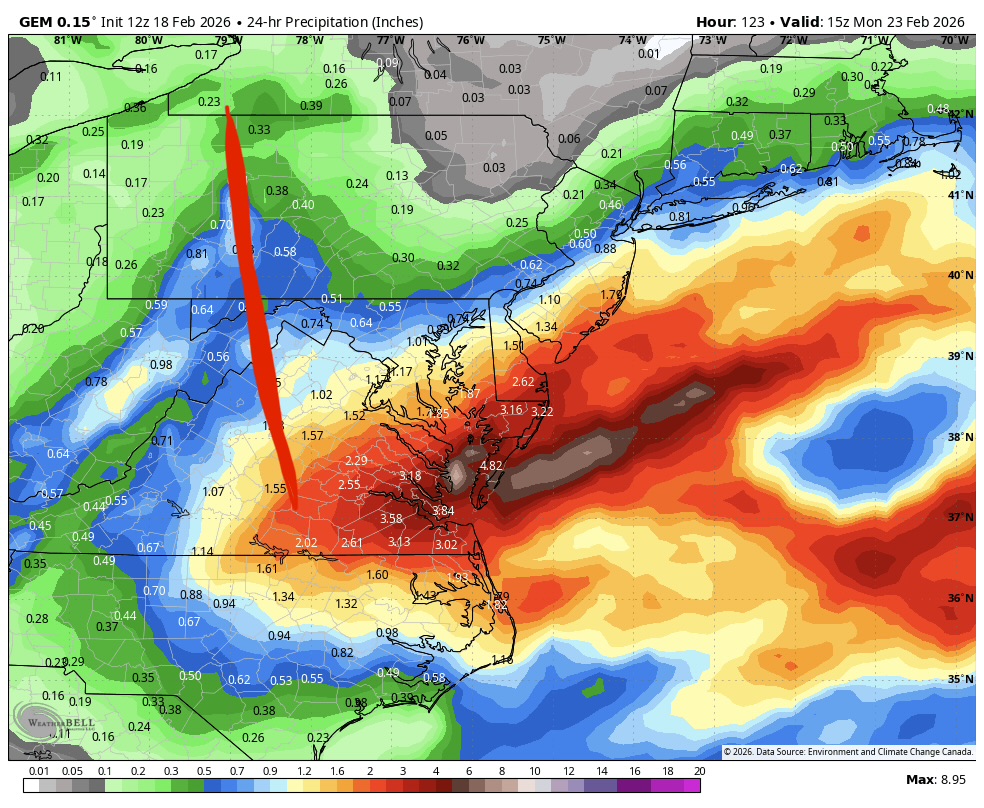
Ggem Am I blind? The IVT is trending east on everything I see
-
Feb 22nd/23rd "There's no way..." Storm Thread
psuhoffman replied to Maestrobjwa's topic in Mid Atlantic
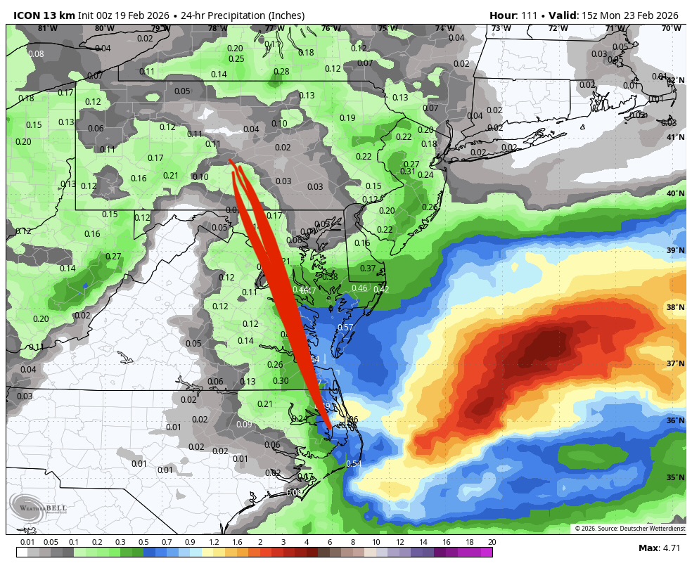
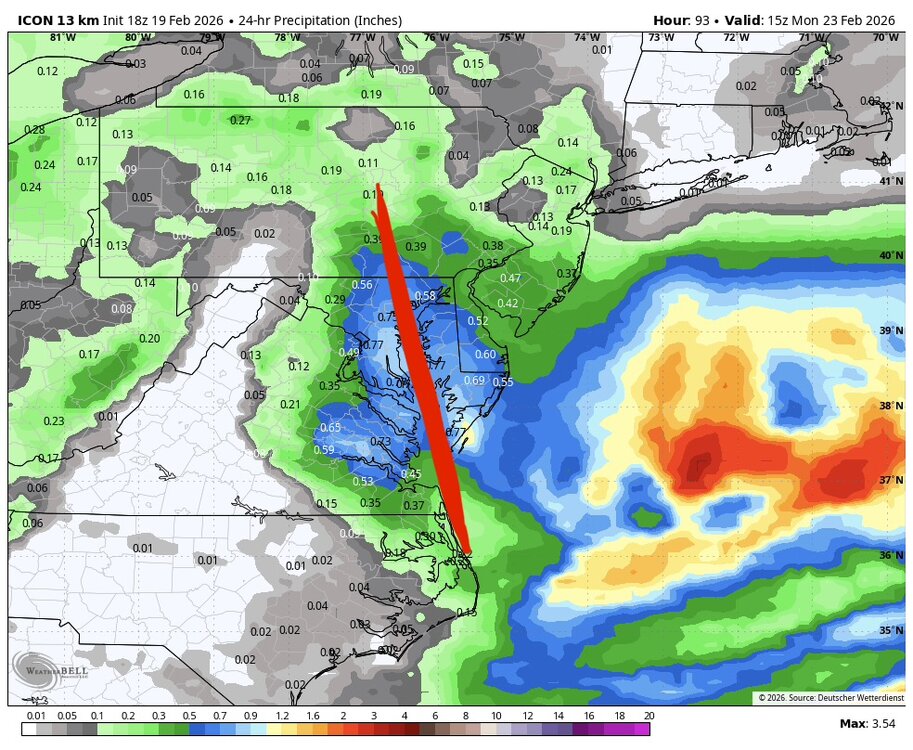
Icon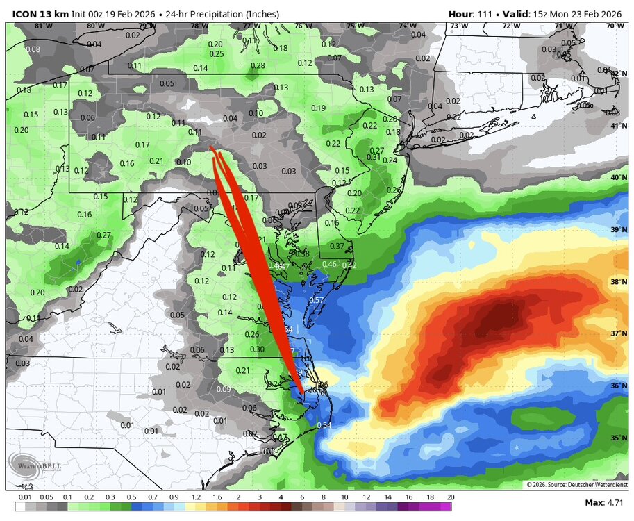
-
Feb 22nd/23rd "There's no way..." Storm Thread
psuhoffman replied to Maestrobjwa's topic in Mid Atlantic
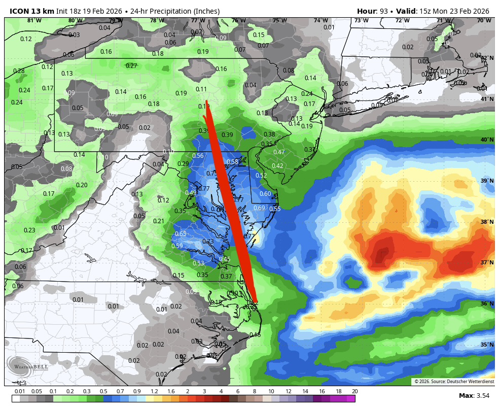
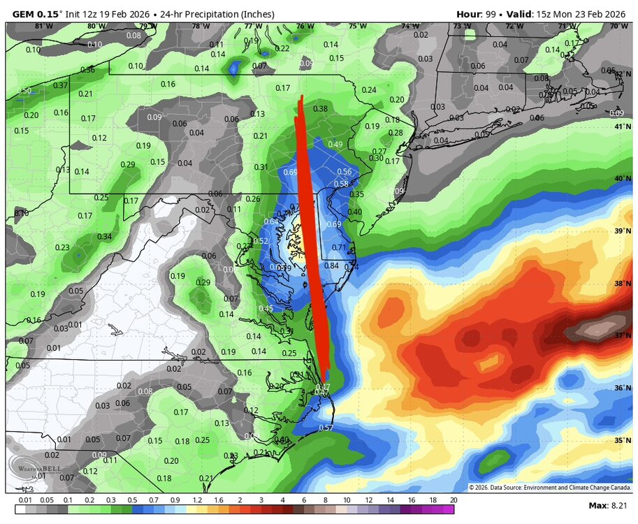
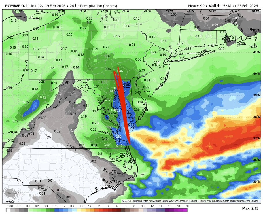
sorry please tell me what I’m missing IVT yesterday v now Euro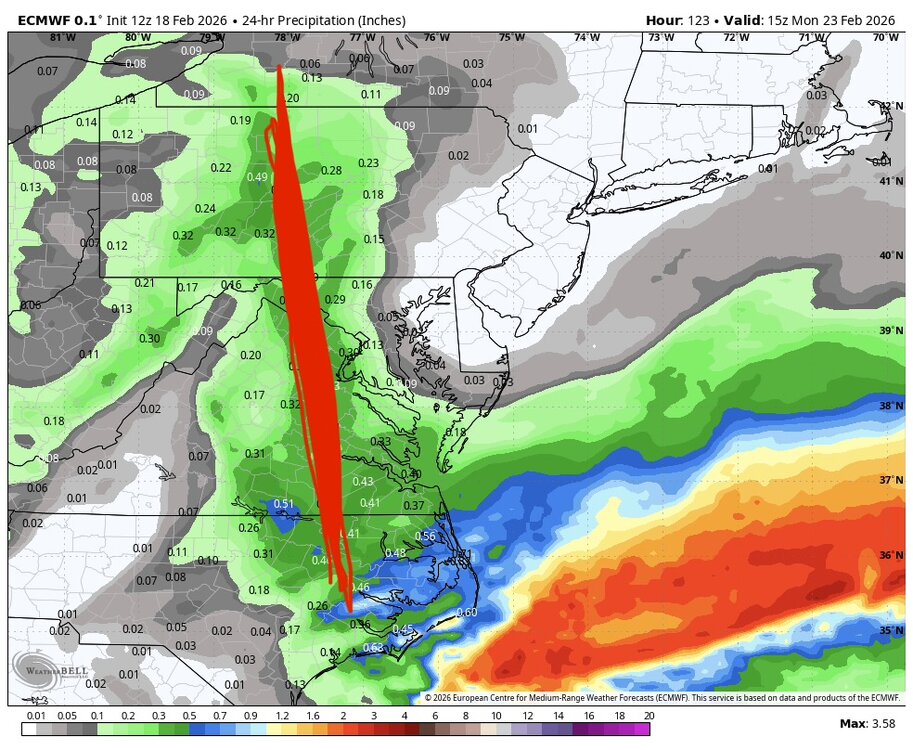
-
Feb 22nd/23rd "There's no way..." Storm Thread
psuhoffman replied to Maestrobjwa's topic in Mid Atlantic
It’s jumpy. But if you go back and put a line through the axis of the IVT 24 hours ago and average all the models together the mean was somewhere through west of DC up to like Frederick. Remember we were east of the heaviest qpf. Now we’re on the western edge. -
Feb 22nd/23rd "There's no way..." Storm Thread
psuhoffman replied to Maestrobjwa's topic in Mid Atlantic
Likely the meet in the middle with a 70/30 or 60/40 lean towards the other globals. Issue is that’s no good for us. A compromise is a miss. Just a closer miss. Could help the Delmarva. -
Feb 22nd/23rd "There's no way..." Storm Thread
psuhoffman replied to Maestrobjwa's topic in Mid Atlantic
It’s not it’s shifted the axis of the IVT slightly east AGAIN! -
Feb 22nd/23rd "There's no way..." Storm Thread
psuhoffman replied to Maestrobjwa's topic in Mid Atlantic
I need someone to stop the slow bleed of the IVT northeast every damn run. Y’all are focused on the lost cause coastal but that IVT is realistically our only shot and has no one else noticed it’s slowly bleeding like 10-20 miles northeast every run! If that keeps up it’s gonna end up congrats Philly or even NYC by the time this gets here. -
Feb 22nd/23rd "There's no way..." Storm Thread
psuhoffman replied to Maestrobjwa's topic in Mid Atlantic
He got jokes -
Feb 22nd/23rd "There's no way..." Storm Thread
psuhoffman replied to Maestrobjwa's topic in Mid Atlantic
@SnowenOutThere nice synopsis. People were saying it merges the two, Not really it just partially phases them early on enough that the main energy rounds the base and is focused on the lead SW. At 72hr you can see the trailing SW still there but unlike all other guidance because of what happened around hr24-36 the lead SW is the more amplified one and taken on a negative tilt. The trailing wave being the main one is useless because the timing is all wrong. The lead wave takes the surface low way OTS with it and there’s nothing for the trailing wave to amplify. It does activate the IVT connected to the departing coastal and we could score a consolation that way but unless the lead SW becomes the main player any surface wave will be long gone OTS. -
Feb 22nd/23rd "There's no way..." Storm Thread
psuhoffman replied to Maestrobjwa's topic in Mid Atlantic
The real skilled Mets here aren’t predicting a blizzard. No one is buying that crazy gfs run. -
Feb 22nd/23rd "There's no way..." Storm Thread
psuhoffman replied to Maestrobjwa's topic in Mid Atlantic
I think you have a misunderstanding. No one thinks the models are perfect and don’t need to continue to improve. But what’s the alternative? They’re just a tool. A good forecaster also factors in historical knowledge and sound meteorological principles. But they didn’t start using models because they’re lazy. They did because other methods are even worse! One day forecast used to bust horribly using pre model methodology. Forecasts and warning times have improved substantially because of the utilization of models. So while they are flawed what’s your method that would be better? Most non model methods wouldn’t even work beyond a couple days! -
Feb 22nd/23rd "There's no way..." Storm Thread
psuhoffman replied to Maestrobjwa's topic in Mid Atlantic
But what I don’t like is other than the gfs everything is IVT related and that feature is bleeding northeast across guidance which seems to be what usually happens. They are very rare down here. They more commonly end up impacting to our northeast. My fear is the coastal is a non thing and the IVT trends northeast and ends up a Philly thing and…well ya -
Feb 22nd/23rd "There's no way..." Storm Thread
psuhoffman replied to Maestrobjwa's topic in Mid Atlantic
If a low gets too intense and vertically stacks the moisture transport is cut off to its west and everything is focused on the intense but compact qpf field. We saw it somewhat with that coastal bomb in 2018 -
Feb 22nd/23rd "There's no way..." Storm Thread
psuhoffman replied to Maestrobjwa's topic in Mid Atlantic
Oh I know just pointing out how rare it is…also noting it because assuming we don’t get a gfs solution it shows how difficult it would be to win from the coastal here we need the low tracking up the bay basically. -
Feb 22nd/23rd "There's no way..." Storm Thread
psuhoffman replied to Maestrobjwa's topic in Mid Atlantic
It was off on its own 2-3 days before Jan 25 but not this far. This is odd. But it does suck. -
Feb 22nd/23rd "There's no way..." Storm Thread
psuhoffman replied to Maestrobjwa's topic in Mid Atlantic
Obviously this doesn’t matter but it took a track of the slp to the mouth of the Potomac to get the deform band back across our area. All the runs that have a bomb wind up the storm so tight it’s unusual. A track that close usually has precip type issues all the way to the blue ridge and heavy snow to state college. -
Feb 22nd/23rd "There's no way..." Storm Thread
psuhoffman replied to Maestrobjwa's topic in Mid Atlantic
It’s crap. Most of that snow is light and associated with the mid level instability. Look at the stuff to our south here. That’s the stuff that was back over KY when we were excited. That’s what will become the developing wave. Everything NW of that is just instability or INV trough related.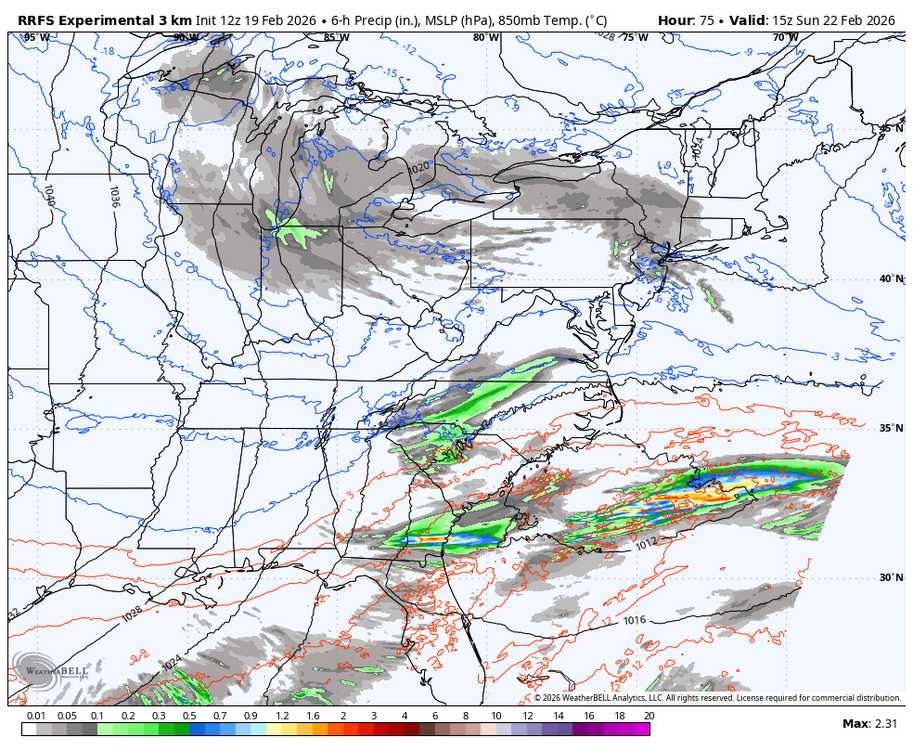
-
Feb 22nd/23rd "There's no way..." Storm Thread
psuhoffman replied to Maestrobjwa's topic in Mid Atlantic
For Bermuda? That thing is WAY easy -
Feb 22nd/23rd "There's no way..." Storm Thread
psuhoffman replied to Maestrobjwa's topic in Mid Atlantic
My fear is the inverted trough keeps trending east and we end up west of everything. That’s my “how we get screwed” vision. -
I nominated it for @Maestrobjwa since he is so interested in this week every year