

psuhoffman
-
Posts
27,419 -
Joined
-
Last visited
Content Type
Profiles
Blogs
Forums
American Weather
Media Demo
Store
Gallery
Everything posted by psuhoffman
-
Baltimore went over a decade without a 12" snowstorm twice, in the 40's and 50's and from 1968-1979. Baltimore went 8 years without a 12" snowstorm from 1988-1995. You were falling prey to recency bias in thinking a fluke of chance that recently there seemed to be a regularity or pattern to big snows in Baltimore was something that was likely to continue. The fact it had been a long time since we had a long extended run without a big snowstorm simply meant we were due for such a thing. I don't buy "were due" either but you could just as easily look at it that way as saying we are due for a snowstorm every 3/4 years! As for 2 foot storms... well Baltimore can go multiple decades without a storm like that! Again only recently have those occurred with such frequency and regularity. Longer term evidence suggests more randomness to our big snowstorms. Baltimore did have warning criteria snowstorms in March 18 and January 19 so it hasn't been that long since a "decent" snow event.
-
Baltimore’s new avg is 19.4 and median is 15.3 for 1991-2020. But I think CAPEs point with expectations is valid. Baltimore has beaten median 2 of the last 4 years and 5/7. If you used median as your goal/expectation for a “good” winter you will be satisfied more frequently. If you use avg you will be disappointed about 70% of the time. If median isn’t enough to be satisfied...well moving is the more realistic option vs expecting our climo to change.
-
When you just glance at it there does seem to be a lot of big winters near minimums. But there are several factors that make me question the correlation when you look closer. First is the lack of timeframe consistency Wrt the minimum. Sometimes the effect was the year of the minimum (1964). Sometimes the year after (1987/2010). Sometimes 2 years after???(1978). Sometimes the year before (1996). On top of that the way we got the “big winter” wasn’t always consistent. Sometimes it was a widespread cold snowy winter like 1978/1996. But 1987 wasn’t really a memorable winter anywhere except our local region. That lack of consistency suggests more randomness than I’m comfortable with when establishing clear causality. Third, if we’re going to stretch it to a 3 year window to make the correlation work you have to consider how much more often does a big winter occur than you would normally expect during a random 3 year window? Let’s look at that closer. More recently (last 40 years) the frequency of an above avg snow winter in Baltimore is more like 35%, but if we go back through the last 11 cycles it’s closer to 40%. During that time the avg frequency of an above avg winter is every 2.5 winters. That means most random 3 year periods would likely have one above avg winter just by random chance. Not every one but the majority. That makes this correlation potentially less impressive. Furthermore you have to adjust for averages during different periods. If we do that there was no big winter anywhere around the 1954 minimum. There was a 22” winter which was avg for that period and it was a generally crappy winter across the area but BWI was a local max. That seems a weak argument to count a year like that towards the correlation. There was no big winter near the 1902 or 1913 minimums either. The results leave us with slightly more above normal years than expected if random but only slightly. Not enough to suggest strong causality probabilities. All that said doesn’t mean we can’t get a big snow year simply from my favorite weather (and life) correlation... “shit happens”
-
But did it ever really work. It was too small a sample to really show true statistically significant causality correlation. Consider historically we tend to get a big winter every 3-5 years anyways. And I’ve seen winters on either side of past minimums attributed to that. So that’s like a 3 year window. Could easily have been only a very minor weak correlation and as much to do with random chance as a true strong causality. That said hope this year proves that wrong. It’s all we got.
-
You are actually in a better spot to try to luck into a warning level snow in a Nina without blocking. You can catch the west edge of some progressive late developing storms like are common in a Nina. DC is just too far west. Heck even with blocking they miss a lot but it at least gives them a chance. All the decent Nina snows in DC had blocking help. March 18, January 2011, March 2009, February 2006, Jan 2000, March 99, and all the 96 storms featured at least some blocking leading up to them.
-
@CAPE of course records are made to be broken. I’m sure there have been big snow in a Nina absent blocking if you go back far enough. I’m sure it’s possible. Just very unlikely. Kinda like 2010. But maybe this year is the 1/100 fluke. But if you told me today the NAO behaves like last winter and is wall to wall positive I would bet DC ends up under 5” snowfall!
-
I don’t disagree, just pointing out the fact that in a Nina DC really needs some HL blocking to get a decent snow. It was shocking how much so. In all other enso conditions DC can luck their way to a warning event without blocking. But in a Nina even cold periods absent blocking typically end up dry. No stj tends to be a big problem. Can’t luck into a progressive southern steam wave. Need a strong block to force the northern stream to dig under us and pick up some gulf moisture. I’m not saying we get blocking. And we don’t need long periods, we could cash in with transient blocking. Just saying the Nina’s that featured a raging +NAO wall to wall like last year...well they ended up like last year. We need to hope we get at least some favorable looks up top (even if only temporary) or the panic room will be very busy!
-
Keep this in mind though...going back 50 years DC hasn’t had a warning level snow during a Nina without some NAO blocking preceding the event. I went back and looked at EVERY Nina warning event a few years ago and found every one was set up by blocking. In some cases it was a bootleg block that didn’t necessarily tank the numerical NAO. But when I examined the h5 it was there. So absent any blocking kiss any chances of more than minor events in DC goodbye.
-
I’m sure there will be an effect due to the changing pac base state, but Im not sure what that will be. The warmer waters around enso could act to enhance the effect due to greater contrast and gradient. On the other hand the warmer profile could wash out the weak cold anomalies. Interestingly there gave only been 4 truly epic snowfall winters in the last 30 years. And 2 were in warm enso and 2 cold. So Im not sure the odds of a 30”+ DC winter is actually affected much by enso. But the odds of beating avg definitely are. Without the STJ we simply have less chances of getting lucky and any snow here is an anomaly and requires luck. To get the epic winters requires some version of amazing high latitude ridging (EPO/AO/NAO) and that can override enso when it happens. But it’s so rare and hard to predict ahead of time.
-
Thank you will definitely take a look!
-
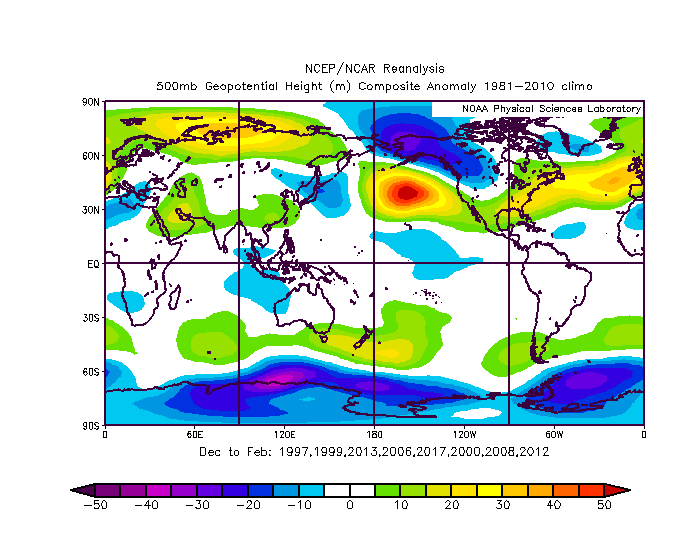
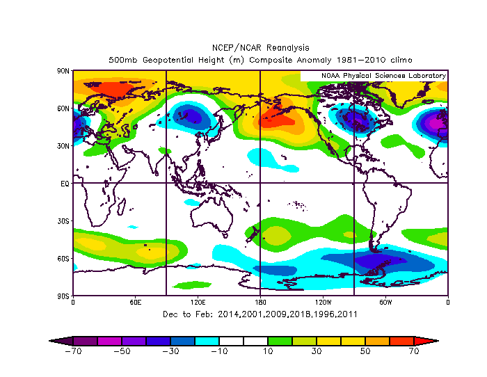
You can see the difference in the Pacific ridge between the colder years and warmer Colder Nina years Warmer Nina years
-
I am currently doing my work looking at winter stuff and getting some ideas...but its going slow because honestly I have better things to do right now. It's hard to get at some of that because simply using the monthly NAO numbers can hide the true pattern. For instance, January 2000 comes in with a +NAO because periods of extreme + anomalies hides the 10 day period of -NAO in the means and as that month proves we don't need the whole month to be -NAO to get snowfall. I am pretty sure everyone here remembers the snowy period that month more than the uneventful period that came before it. In some other instances...features that impact the way the NAO is calculated but has very little bearing on our snow prospects impacts the raw numbers. January and Feb 1996 come in near neutral on the NAO raw numbers...and just looking at that would not give you a good idea of what the true impact of blocking was that year. That said... going back to 1990 these are the splits Cold Neutral Winters: 96/97: Some blocking Dec and Jan but did us very little good in snowfall 2012/13 Blocking in Feb and Mar but did DC very little good in snowfall...did help places west and north of DC though 2013/14: very little NAO blocking but amazing EPO blocking that extended through the AO domain all winter, very odd for a cold enso winter Weak Nina 2000/01: some major blocking periods in Dec and March that did DC no good except for 2 painful close misses! 05/06: Blocking periods in Dec and Feb that did lead to snow in DC, one of our better snowfall Nina's, this was one of the few examples where an excellent NAO offset a crap PAC 08/09: There were a couple periods of good west based blocking in Jan and Feb but it did DC little good wrt snowfall, cold/dry periods 2016/17: no blocking until March 2017/18: no blocking until March Moderate Nina 1995/96 no need to explain 2011/12: no blocking dumpster fire winter start to finish Strong Nina 1998/99: great blocking in March that did lead to snow in DC 1999/2000: Blocking in January that did lead to snow in DC 2007/08: no blocking dumpster fire winter 2010/11: Great blocking in December and January that lead to "some" snow in DC but a mostly frustrating period watching Philly and NYC get record snowfalls Some observations so far...there is very little observable difference in our chances of a decent snowfall based on the strength of the Nina. First of there are 2 obvious outliers in 1996 and 2014. Each due to extreme high latitude ridging, one in the NAO domain and one in the EPO. One was a cold neutral and one a moderate nina. I think we can simply toss both as the obvious outliers. That doesn't mean they can't happen again, just that they are anomalies that shouldn't be "expected" in a cold enso winter and that skew the mean of all the other more typical years so it's better to just chalk them up to "bleep happens". But there are some decent and some awful snowfall years in each of the subsets of cold enso winters. Actually only 1 of the 4 strong nina's in the last 30 years was a really bad awful winter wrt snowfall in DC. The other 3 were all in the more "decent" nina snowfall outcome range (which is still probably way below the standards of some people in here, they know who they are, and they might want to just take a nap until 2022). There are 2 clear cold enso types that all the other years fall into. A warmer and a cold variety. Unfortunately the cold variety does NOT mean a lot of snow. They are typically mostly frustrating years like 2001/2009/2011/2018 where DC eeks its way to a slightly below avg (near median) snowfall winter with clippers and being on the fringe edge of northern stream storms and watches Philly and NYC get buried by miller b after miller b. However, they do not typically end up complete awful snow-less winters like last year. The warmer type opens the door to a complete crap winter in DC like 2008/2012/2017 where there is virtually no snow. But there were also some examples where a period of NAO blocking was able to provide either a period of snowfall or an anomalous storm (1999/2000/2006) within an overall warm nina winter. What differentiates the colder/warmer cold enso types seems to be a combination of the orientation of the pacific ridge in conjuncture with any AO/NAO blocking. If the PAC ridge orients itself further north and can encroach into AK and the northern EPO domain...then it can lead to a colder regime into the northeastern US. This type also seems to be in conjunction with a bit more propensity for NAO blocking. The warmer type seems to have a pac ridge centered further south (like last winter) which makes sense as that would act to enhance the jet to its north and speed up the polar vortex and...well we saw the results of that! So far being able to easily identify markers that would help predict ahead of time which type is coming (or the possibility we get one of the 96/2014 type anomalies) is not easy. From a pacific SST stand point there is definitely some tells that you do NOT want, like a very cold northeast pac sst profile...and we don't have that. But there are still a mix of good/bad results in the set without that marker. I think @Isotherm may have a much better methodology of using the actual atmospheric circulation patterns to predict these phases rather than the SST anomalies but I am just starting to dip my toe into that pond. Hopefully he will post some on that soon. I am not done analyzing things yet, and we are still super early so factors will change yet, but it's clear this coming winter will favor below avg snowfall simply from the cold enso factor. How much below avg depends on those other factors.
-
@CAPE the North Pacific sst profile is nothing close to the precursor to the worst Nina’s so that’s good. It’s not really all that close to the best either as it’s an anomalously warm profile for a developing Nina. So hard to say what that means. The odd thing is the best Nina’s tended to have warmer water encroaching closer to the EPO domain while the worst were an ice bath all across the north pac. Odd in that it’s the opposite of what you want the sst profile there ri be in a nino. The best overall pac sst match right now is actually late summer/fall of 2013 so that’s not all bad. But that was a weird year with an unexpected result so not sure rooting for a repeat of that is likely.
-
If we want to hold out hope the current global sst anomalies aren’t far off from this time in 2013. @Maestrobjwa if you want to know why 1996 was so good, the first half of that winter was dominated by a good Atlantic and pacific. A pronounced Aleutian low and west based NAO blocking. The second half was much more variable but with recurring periods of Enough blocking to score a few more snow events. If your asking for a predictive reason...I can’t say for sure. Even now looking at the sst anomalies leading into that winter I wouldn’t have expected that. Sometimes anomalies happen and we don’t fully understand why.
-
When you start parting into such specific criteria you end up with not enough samples to get any meaningful results. Even 15 isn’t really enough of a sample to say much other than generalities. But there seems to be an even mix of decent Nina’s and dreg ones in both the +/- QBO category.
-
@CAPE I’ll post the h5 composites later when I have time but looking at the last 15 Nina’s going back all the way to 1984 I see absolutely no significant correlation between the QBO and snowfall in our area. 1996 skews things horribly on those plots. Truth is 4 of the 5 worst Nina snowfall years in DC were negative QBO. 1989/2001/2008/2012. The one awful positive qbo winter was 2017. On the other hand if you take out 1996 the 2 next best snowfall Nina years at DC we’re 1986 and 2000 both +QBO. Truth is other than 1996 Nina’s all are a range between totally god awful and average wrt snowfall. With the stj absent in Nina’s getting above avg snow is just VERY unlikely. But the QBO does not seem to have any statistically significant predicting value on differentiating between the really awful Nina snowfall years and the decent ones. When I have time I will look at the enso profiles (East/West/basin wide Nina) and north pac SSTs to see if one of those is a better predictor if Nina outcomes. Hopefully not north pac sst as those look like hot garbage right now also.
-
14/15 and 15/16 went about what analogs would have suggested. 2019 wasn’t far off for a weak nino. They can go either way and usually end up near normal. It’s really moderate ninos that have tended to be the big years. That said all your criticisms of analog forecasts are true. Problem is with seasonal forecasts there isn’t much choice. You can’t really forecast pattern progression for months out in time. So we’re left looking at past progressions for clues. “Analogs”. Now I think SST analogs are becoming problematic given the changing base state of the pacific right now. Isotherm might be into something with using other factors to predict global patterns. But it’s still the same principle. That’s why seasonal is such low skill.
-
But there is always a positive. JB didn’t have last winter as the primary analog. Only the second. The first analog was 2017 and that year DC had 3.4”. Thats 500% more than last year!!!!! Boom.
-
Like I said above it’s way too early to say anything is a lock so maybe the winter turns out ok. But you are looking at this wrong. It doesn’t matter how often people who have a cold/snow bias bust when they predict cold/snow. What you need to look at is what is their track record when they go warm. Because in JBs case it’s pretty damn good. Now that’s not a compliment to him. It’s not a fair metric because he only forecasts a below avg snowfall winter in the mid Atlantic like 2 times a decade (ridiculous considering that’s about how often we get above avg snow) when it’s so obvious that it’s probably going to be a dud winter that he gives up the hype and uses those years as a chance to save some cred. But still when the pattern drivers are lined up so god awful that even the most epic snow hype weenies are saying it’s not going to snow that is not a good thing! Surprises happen. Maybe things flip by December. Or maybe we get lucky in an otherwise crap pattern a couple times and that’s all it really takes to salvage a decent winter by our standards. But let’s stop pretending seeing all the typically snowy forecasters saying a snowless torch winter is coming is a good thing. Sorry I’m not a “denial” kind of person.
-
We very well could have a snowy winter. Sometimes the weather just does what it wants. But just because a forecast busts when it went cold doesn’t mean we want to see everyone going warm either! Fact is a cold snowy forecast is way more likely to bust just because our climo is skewed that way. We typically get 2-3 really good winters a decade and the rest are petty meh. Those 2/3 good winters inflate our average and our expectation. But the majority (even before global warming) are warm and every flake is a battle. And when even reliably cold biased outlets are going warm there is a legit reason. But every once in a while we do get a pleasant surprise. I’m not saying there is no hope or give up. But pure odds say we are very likely headed towards one of the “meh” years. Even so that doesn’t mean it has to be as bad as last year. Many of those years at least feature one or two fluke snowstorms. So even if the year as a whole goes poorly we will still likely get at least some opportunities and tracking. Just keeping my expectations pretty low for now.
-
I’ve gone through the records back to the 1800s and other than in the 1960s that was never a common thing.
-
Its all crap. Sst in the mjo domain is opposite what we want . Pdo. Enso. Atlantic everything isn’t right. I’m not wasting time debating which awful is most awful.
-
My scientific analysis of that sst chart
-
About once every decade JB does go warm/snowless and it’s usually when it’s so obvious he might as well use those years to save some modicum of dignity.
-
I think you should go investigate


