uofmiami
-
Posts
2,279 -
Joined
-
Last visited
Content Type
Profiles
Blogs
Forums
American Weather
Media Demo
Store
Gallery
Everything posted by uofmiami
-
Downtown Miami is night and day difference compared to now with the amount of high rises. Also, the wind radius was so tight on the storm as it came ashore that 10 miles made all the difference between 80 mph winds and those gusting to 200 mph. Once N of Coral Gables the impacts lessened, while it got worse heading S to Homestead, which looked like a nuke went off. I know at RSMAS on Virginia Key the storm surge was only 5 feet compared to 17 feet down by Homestead. https://hurricanes.earth.miami.edu/stormtide/
-
I don't doubt that one bit. The inflow of new residents is still outpacing those moving out, but some are moving out after having settled in FL for a year or so.
-
They already are, there's been articles in the NYT & WSJ about it. Many are moving to GA & NC it seems. Some are moving back to the NYC area as well.
-
It’s those warm overnight lows you’ve posted maps on. Seems to be a common theme. I’m sure we’ll have more record high minimums this summer again too.
-
67 at both my stations, forecast was for 59. Nice bust!
-
Good agreement with GEFS and EPS for that period before ridge goes away after the 20th. Hope the signal stays as we get closer to the period.
-
74 in Syosset & 75 in Muttontown for the high.
-
Ouch, glad I left Woodstock, VT at 5:30pm to head home after seeing eclipse and getting late lunch. 13 hours is brutal.
-
71.9 in Syosset & 71.5 in Muttontown currently.
-
There was snow on the ground yesterday in VT. Should have taken a drive up for the eclipse.
-
I know taking I-91 S there was a bad accident S of Brattleboro, but Waze routed us around it, once past that it was smooth sailing until Cross Island Pkwy got knocked down to 1 lane for paving around 10pm. Should have taken Clearview to LIE instead of listening to Waze at that point but was exhausted from driving up that morning and back that evening/night.
-
I'm 61 in Muttontown and 59 in Syosset currently. You are off to the races like EWR!
-
My little ones had enough of the car, this is good enough
-
Made it to Woodstock VT with the kids. 99% is good enough. Surprised we made it with time to spare. Enjoy the eclipse all.
-
It was brutal yesterday evening and this morning for it. My son’s team as least won one game. Tomorrow morning is 3rd game of weekend tournament at 8:45. Going to be another miserable day for baseball.
-
Nanny state!
-
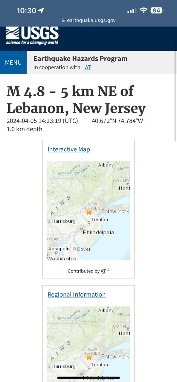
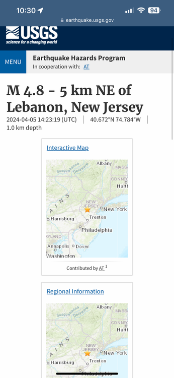
https://earthquake.usgs.gov/earthquakes/eventpage/at00sbh3yv/executive
-
Overall departure not one of warmth, have to head to WV!
-
Extended summer stormlover74 future snow hole banter thread 23
uofmiami replied to BxEngine's topic in New York City Metro
Looks like CSU is all in for a very active hurricane season: -
Not surprised, two weeks ago I posted a sustained warm pattern would wait until mid April. Hope that doesn’t get pushed off further, as this isn’t great spring weather currently.
-
Seems it. I’m at 2.22” in Syosset & 2” in Muttontown so far.
-
Only 33mph so far at both my stations. Wind advisory would have been fine.
-
Maybe for inland locations perhaps, otherwise 60s it seems.