wthrmn654
-
Posts
3,953 -
Joined
-
Last visited
Content Type
Profiles
Blogs
Forums
American Weather
Media Demo
Store
Gallery
Everything posted by wthrmn654
-

Extreme Cold, Snow & Sleet: SECS 1/24 - 1/26
wthrmn654 replied to TriPol's topic in New York City Metro
I can't find the post I saw on Facebook but here's.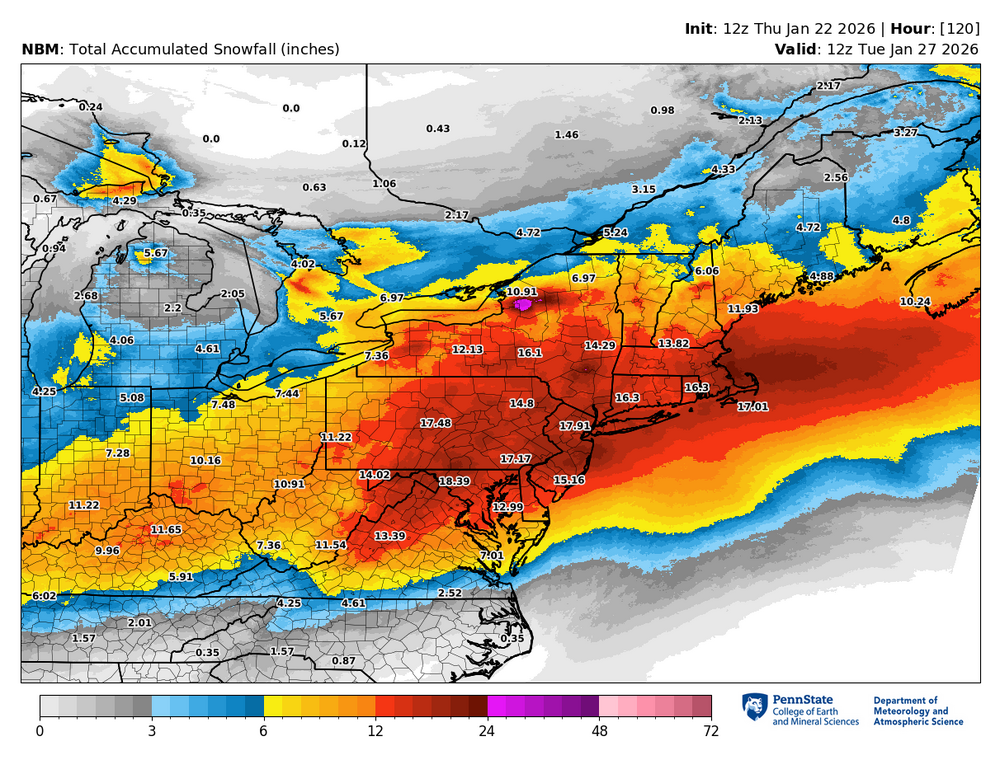
-
Extreme Cold, Snow & Sleet: SECS 1/24 - 1/26
wthrmn654 replied to TriPol's topic in New York City Metro
Upton -
Extreme Cold, Snow & Sleet: SECS 1/24 - 1/26
wthrmn654 replied to TriPol's topic in New York City Metro
My sister near Nashville is going get F up big time with ice -
Extreme Cold, Snow & Sleet: SECS 1/24 - 1/26
wthrmn654 replied to TriPol's topic in New York City Metro
Yeah i know. the map was still showing the old total map. Thought he was on the NWS slack page to -
Extreme Cold, Snow & Sleet: SECS 1/24 - 1/26
wthrmn654 replied to TriPol's topic in New York City Metro
Just saw latest nbm totals have gone up a few inches, they see a slightly cooler storm Matches there forecast map. Very well -
Extreme Cold, Snow & Sleet: SECS 1/24 - 1/26
wthrmn654 replied to TriPol's topic in New York City Metro
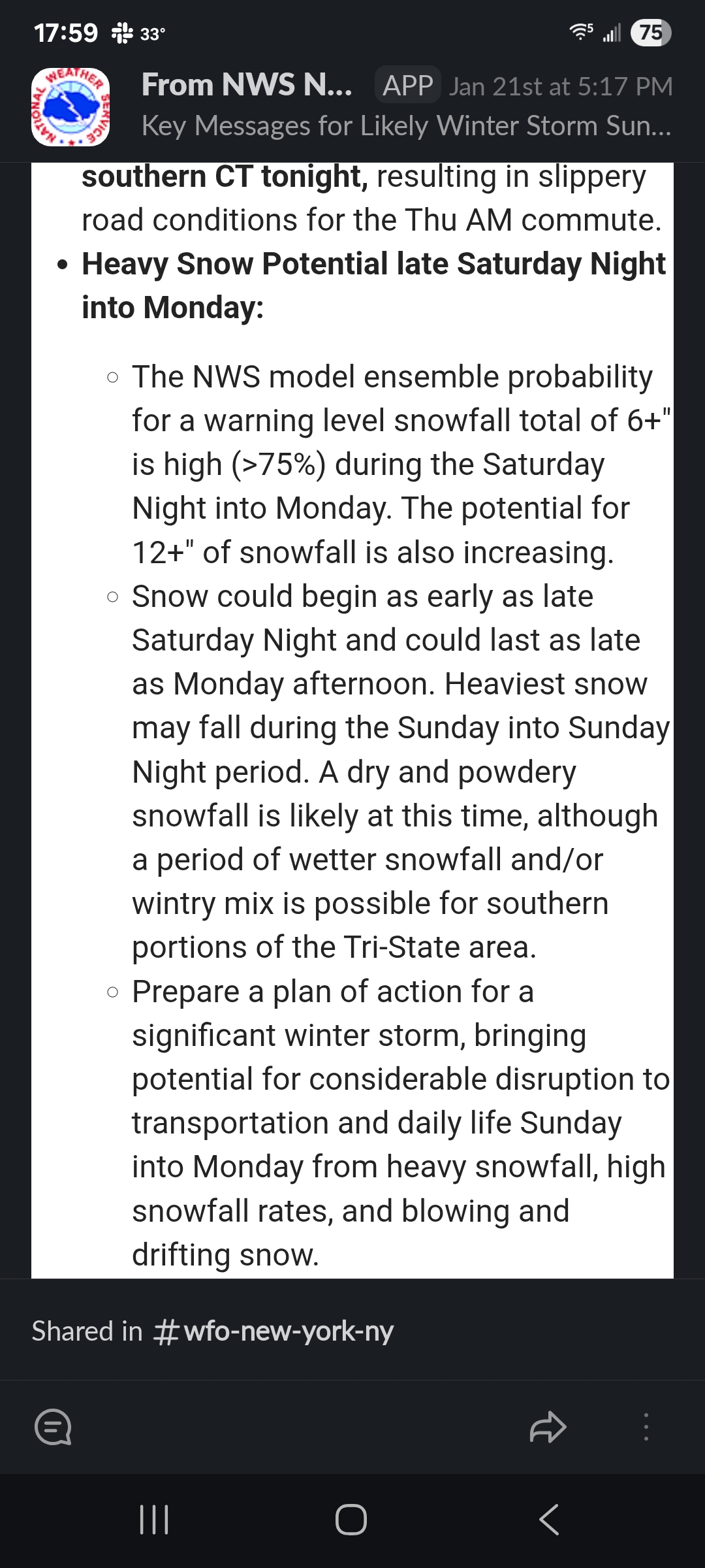
As strong high pressure retreats to the NE late Sat night into Sunday, an expansive winter storm will impact the area from then into Mon. Primary low pressure moving into the TN valley on Sunday should dissipate while a secondary low forms near Cape Hatteras and the VA capes, and then moves to a position just inside the 40N/70W benchmark. Snow should begin in the NYC metro area after midnight Sat night and spread NE to the rest of the CWA by daybreak, with some accumulation of 1-2 inches possible by daybreak for the NYC metro area. Heavy snow is then likely daytime Sunday into Sunday evening via strong front-end H7-8 frontogenetic and thermal forcing aided by an anticyclonic upper jet to the north. Given the cold air mass in place, snow ratios look to be on the high side (15:1) at the onset, and then settle down a little closer to 12:1 as heavier precip arrives and the low to mid levels slowly warm. Depending on the ultimate track of the system, it remains possible enough warm air could intrude aloft to force a brief mix with sleet and/or freezing rain Sunday night, especially for NYC and Long Island. Have only mentioned a slight chance of this occurring, and at any rate the damage will have been done well before then as far as meeting 6+ inch snowfall amounts. Total QPF for the event should be roughly between 1.0-1.5 inches. Watch mentions a boilerplate 6-12 inches likely with localized accumulations over 12 inches, but the above QPF with higher snow ratios could yield widespread potential accumulations of over a foot. -
Extreme Cold, Snow & Sleet: SECS 1/24 - 1/26
wthrmn654 replied to TriPol's topic in New York City Metro
It updated looked like but not on the other section. -
Extreme Cold, Snow & Sleet: SECS 1/24 - 1/26
wthrmn654 replied to TriPol's topic in New York City Metro
Mine shows the other amount -
Extreme Cold, Snow & Sleet: SECS 1/24 - 1/26
wthrmn654 replied to TriPol's topic in New York City Metro
How did you get that lol -
Extreme Cold, Snow & Sleet: SECS 1/24 - 1/26
wthrmn654 replied to TriPol's topic in New York City Metro
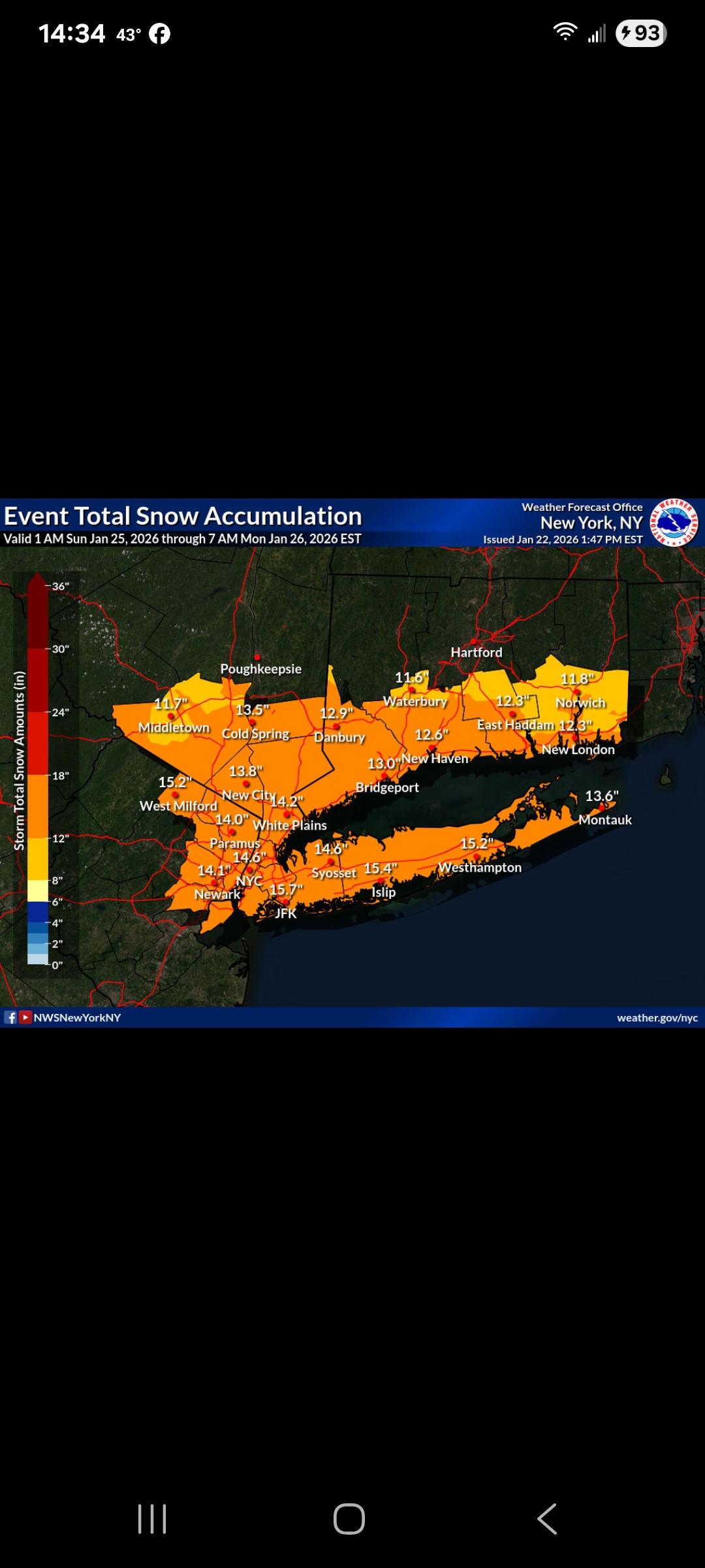
Here you go Upton map.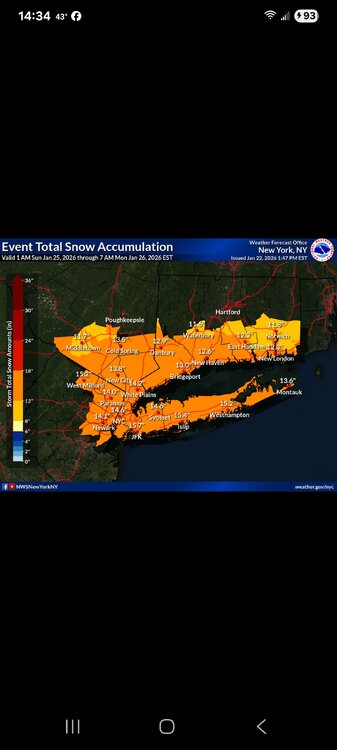
-
Extreme Cold, Snow & Sleet: SECS 1/24 - 1/26
wthrmn654 replied to TriPol's topic in New York City Metro
I'll ask them and look at they're storm briefing on slack in a mintue. Total QPF for the event should be roughly between 1.0-1.5 inches. Watch mentions a boilerplate 6-12 inches likely with localized accumulations over 12 inches, but the above QPF with higher snow ratios could yield widespread potential accumulations of over a foot -
Extreme Cold, Snow & Sleet: SECS 1/24 - 1/26
wthrmn654 replied to TriPol's topic in New York City Metro
Why is there event total 1 am Sunday to 7 pm Sunday... that isn't even the total event? Or am I missing something -
Extreme Cold, Snow & Sleet: SECS 1/24 - 1/26
wthrmn654 replied to TriPol's topic in New York City Metro
So is euro trending slowly to the gfs idea? Guess time will only tell now. -
Extreme Cold, Snow & Sleet: SECS 1/24 - 1/26
wthrmn654 replied to TriPol's topic in New York City Metro
Winds? Are we looking at crazy winds? Drifting will be a biotch -
Extreme Cold, Snow & Sleet: SECS 1/24 - 1/26
wthrmn654 replied to TriPol's topic in New York City Metro
All i know is it happened after sandy cause we were closed for 6 months and when it hit it was bad with snow rain to heavy snow, with so much icy mess buried. -
Extreme Cold, Snow & Sleet: SECS 1/24 - 1/26
wthrmn654 replied to TriPol's topic in New York City Metro
Or Juno idk which storm it was -
Extreme Cold, Snow & Sleet: SECS 1/24 - 1/26
wthrmn654 replied to TriPol's topic in New York City Metro
No, it was about a foot of snow then rain at midnight then back to snow and temperatures dropping like a rock. Cars stranded on 347. Bulldozers and anything that could be used was used. -
Extreme Cold, Snow & Sleet: SECS 1/24 - 1/26
wthrmn654 replied to TriPol's topic in New York City Metro
2014 was Nemo? -
Extreme Cold, Snow & Sleet: SECS 1/24 - 1/26
wthrmn654 replied to TriPol's topic in New York City Metro
Upton also all in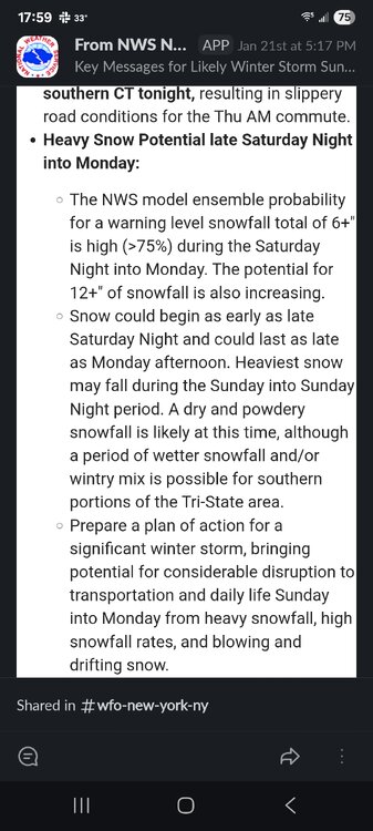
-
Extreme Cold, Snow & Sleet: SECS 1/24 - 1/26
wthrmn654 replied to TriPol's topic in New York City Metro
By Chance was Any data at 12z from recon planes today yet? -
Extreme Cold, Snow & Sleet: SECS 1/24 - 1/26
wthrmn654 replied to TriPol's topic in New York City Metro
Good God, calm down people... everyone needs to take a 15 mintue break from here..... -
Extreme Cold, Snow & Sleet: SECS 1/24 - 1/26
wthrmn654 replied to TriPol's topic in New York City Metro
Good! Finally a big storm coming but no more big shifts north pretty please -
2nd day in a row it barely got cold wtf! I got down to 14 in November with no snow cover and I can only get to 18 last night?! Only 20 day before that......
-
Extreme Cold, Snow & Sleet: SECS 1/24 - 1/26
wthrmn654 replied to TriPol's topic in New York City Metro
It clearly will miss, missing us -
Only got to 20 last night.