wthrmn654
-
Posts
3,953 -
Joined
-
Last visited
Content Type
Profiles
Blogs
Forums
American Weather
Media Demo
Store
Gallery
Everything posted by wthrmn654
-

Extreme Cold, Snow & Sleet: SECS 1/24 - 1/26
wthrmn654 replied to TriPol's topic in New York City Metro
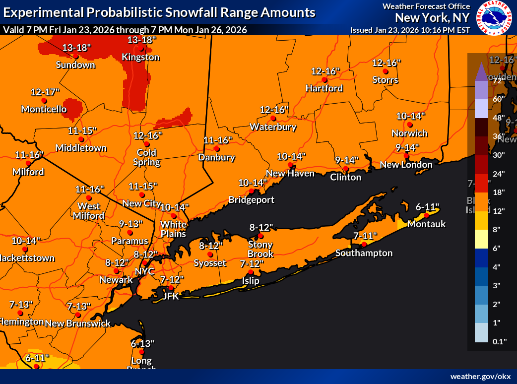
Range versus pinpoint #s i like because it gives a better idea if the variables in the forecast where mix leads to lower end but more snow means higher end. I believe that's the expected # for select locations. -
Extreme Cold, Snow & Sleet: SECS 1/24 - 1/26
wthrmn654 replied to TriPol's topic in New York City Metro
Should use the more accurate version of there forecast then pinpoint amounts. This looks like a good snow forecast map. -
Extreme Cold, Snow & Sleet: SECS 1/24 - 1/26
wthrmn654 replied to TriPol's topic in New York City Metro
That has me in the 12-15 range along with north shore of Long Island. -
Extreme Cold, Snow & Sleet: SECS 1/24 - 1/26
wthrmn654 replied to TriPol's topic in New York City Metro
My sister is in spring hill south of Nashville is snowing there already. Best real time updates possible. -
Extreme Cold, Snow & Sleet: SECS 1/24 - 1/26
wthrmn654 replied to TriPol's topic in New York City Metro
Wtf The wtf was for the post that's gone that showed half a page of gibberish lol -
Extreme Cold, Snow & Sleet: SECS 1/24 - 1/26
wthrmn654 replied to TriPol's topic in New York City Metro
15.5 -
Extreme Cold, Snow & Sleet: SECS 1/24 - 1/26
wthrmn654 replied to TriPol's topic in New York City Metro
Good God is getting windy out. -
Extreme Cold, Snow & Sleet: SECS 1/24 - 1/26
wthrmn654 replied to TriPol's topic in New York City Metro
Fun fact Jan 23,2025 the low temperature was 13... crazy nearly sand a year later -
Extreme Cold, Snow & Sleet: SECS 1/24 - 1/26
wthrmn654 replied to TriPol's topic in New York City Metro
Can't remember the last time I saw such a wild range of snow amounts lol -
Extreme Cold, Snow & Sleet: SECS 1/24 - 1/26
wthrmn654 replied to TriPol's topic in New York City Metro

-
Extreme Cold, Snow & Sleet: SECS 1/24 - 1/26
wthrmn654 replied to TriPol's topic in New York City Metro
You posted precip twice -
Extreme Cold, Snow & Sleet: SECS 1/24 - 1/26
wthrmn654 replied to TriPol's topic in New York City Metro
Anything that does fall liquid wise well become frozen........ very bad -
Extreme Cold, Snow & Sleet: SECS 1/24 - 1/26
wthrmn654 replied to TriPol's topic in New York City Metro
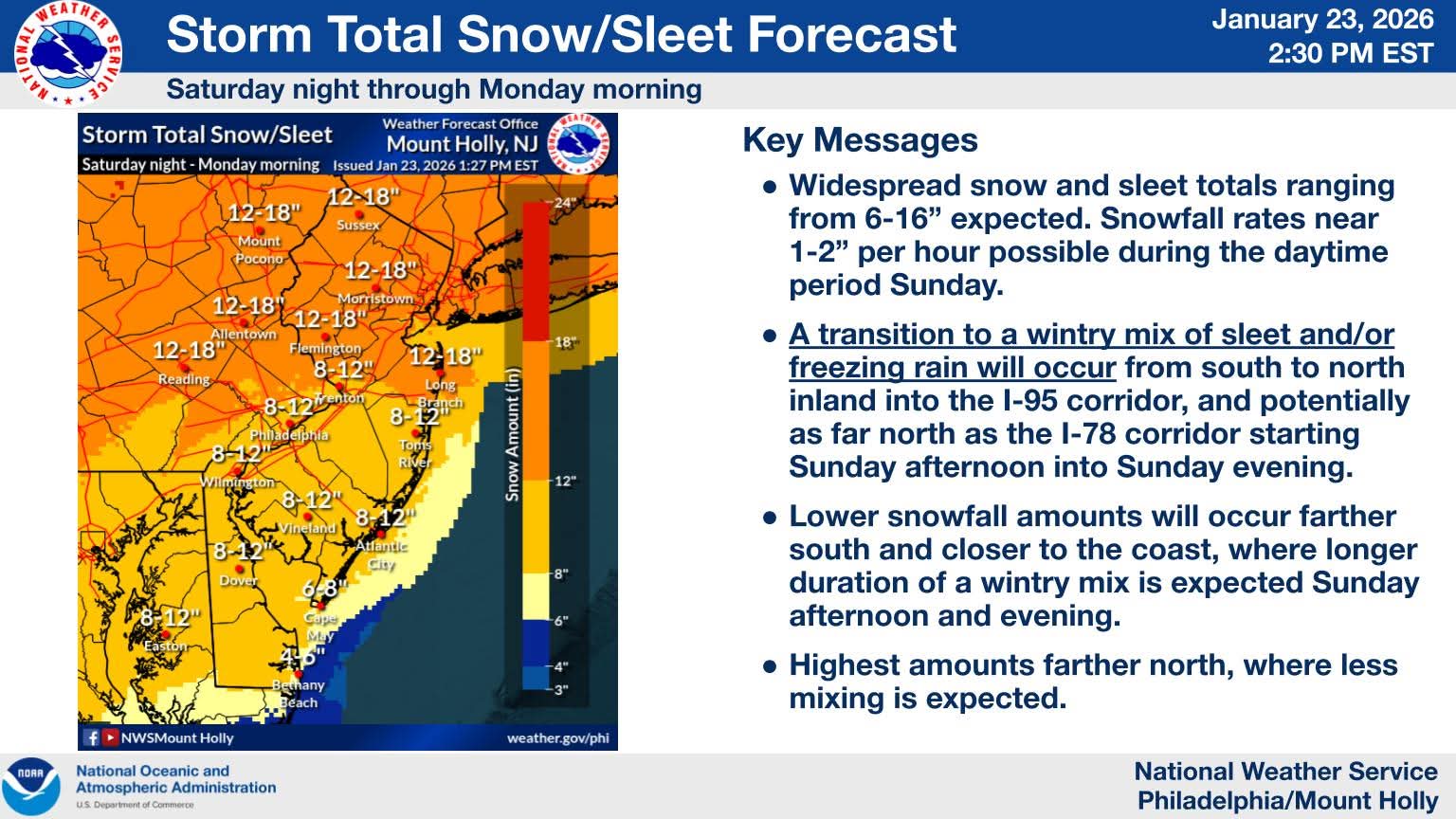
⚠️ The forecast for Sunday's winter storm has been updated. Snowfall amounts have trended down slightly, but ice amounts have trended up slightly for some areas. Regardless of exactly The forecast for Sunday's winter storm has been updated. Snowfall amounts have trended down slightly, but ice amounts have trended up slightly for some areas. Regardless of exactly how much snow falls, our message is the same: Significant impacts are expected for our entire area! Snow will begin after midnight late Saturday night into early Sunday morning. The peak of the storm and heaviest precip will occur during the daytime Sunday into Sunday evening, then wind down into Monday morning. A Winter Storm Warning is now in effect for our entire region. Very cold conditions expected through next weekend. Updated briefing here: https://www.weather.gov/media/phi/current_briefing.pdf
-
Extreme Cold, Snow & Sleet: SECS 1/24 - 1/26
wthrmn654 replied to TriPol's topic in New York City Metro
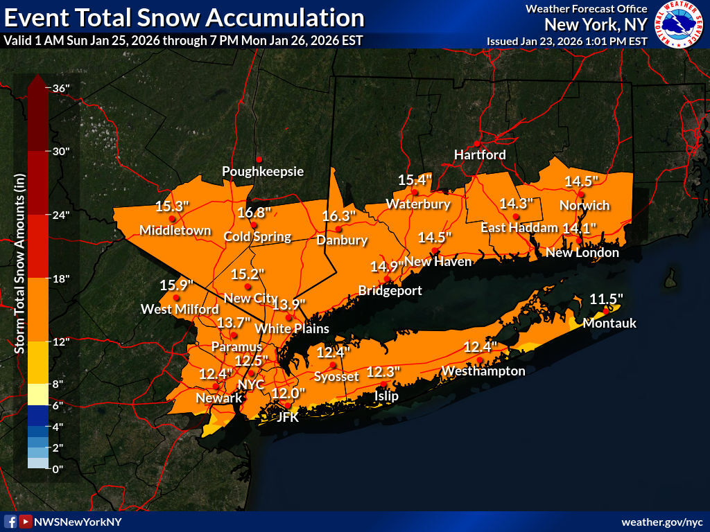
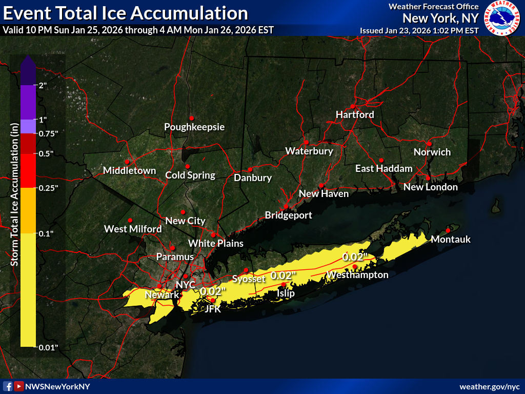
Latest snowfall forecast updated below, along with upgrades to winter storm warnings for the entire area from early Sunday through much of Monday. Totals have increased a bit across the interior and decreased slightly southeast portions of the area. We've also introduced some light ice accumulation for LI and southern parts of NYC for the potential mixing late Sunday/early Monday. Full briefing out in a bit. For those looking for weather information adjacent to our area of coverage, check out the latest winter weather forecasts from our colleagues at Boston/Norton, Philadelphia/Mt Holly, Albany, and Binghamton.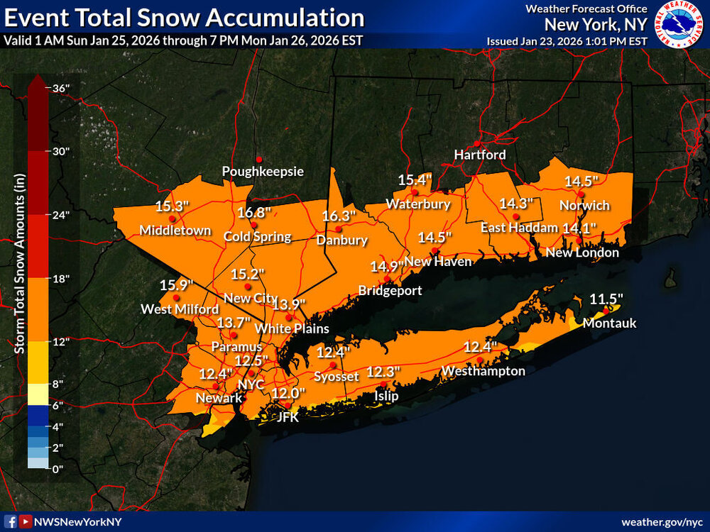

-
Extreme Cold, Snow & Sleet: SECS 1/24 - 1/26
wthrmn654 replied to TriPol's topic in New York City Metro
No lol -
Extreme Cold, Snow & Sleet: SECS 1/24 - 1/26
wthrmn654 replied to TriPol's topic in New York City Metro
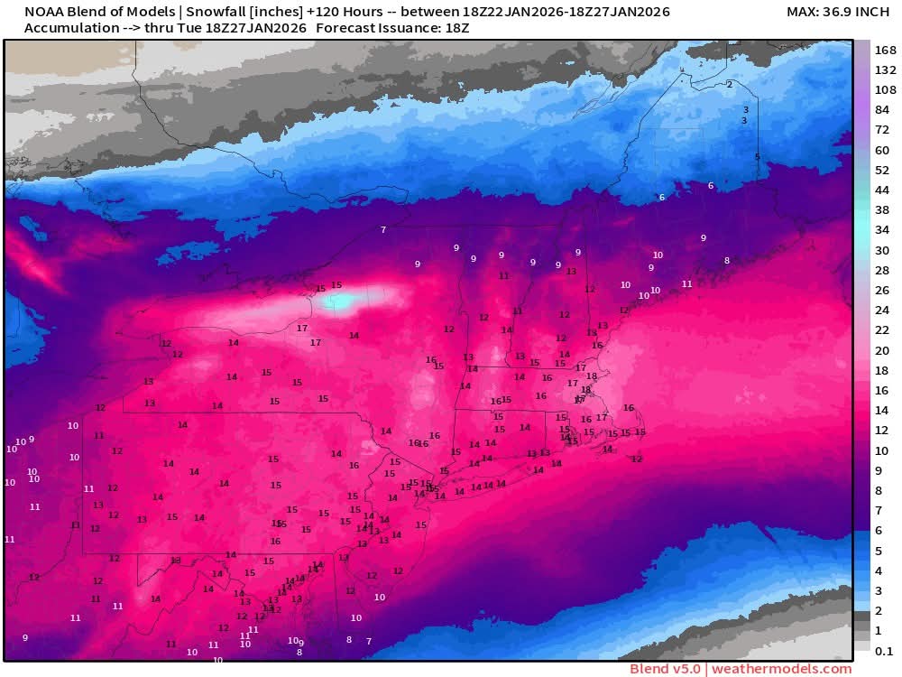
Can you show the rest of the forum area please? Thanks -
Extreme Cold, Snow & Sleet: SECS 1/24 - 1/26
wthrmn654 replied to TriPol's topic in New York City Metro
My sister's who's pregnant in spring hill just south of Nashville is in for a icy disaster -
Extreme Cold, Snow & Sleet: SECS 1/24 - 1/26
wthrmn654 replied to TriPol's topic in New York City Metro
They said start at 15:1 then go to 12:1 in heavier bands -
Extreme Cold, Snow & Sleet: SECS 1/24 - 1/26
wthrmn654 replied to TriPol's topic in New York City Metro
I thought more then 6 would hurt -
Extreme Cold, Snow & Sleet: SECS 1/24 - 1/26
wthrmn654 replied to TriPol's topic in New York City Metro
There going with 15:1 snow ratios and high snowfall rates mostly. -
Extreme Cold, Snow & Sleet: SECS 1/24 - 1/26
wthrmn654 replied to TriPol's topic in New York City Metro
Mount Holly giving some more details on there maps.
-
Extreme Cold, Snow & Sleet: SECS 1/24 - 1/26
wthrmn654 replied to TriPol's topic in New York City Metro
How he worded it was confusing.... made it sound like started at 7 pm ended at 10. -
Extreme Cold, Snow & Sleet: SECS 1/24 - 1/26
wthrmn654 replied to TriPol's topic in New York City Metro
Gfs leading the pack for once? -
Extreme Cold, Snow & Sleet: SECS 1/24 - 1/26
wthrmn654 replied to TriPol's topic in New York City Metro
-
Extreme Cold, Snow & Sleet: SECS 1/24 - 1/26
wthrmn654 replied to TriPol's topic in New York City Metro
Can you include the other half of the forum area please?