
.jpeg.ee54af147b498e279581e1a7251c11d3.jpeg)
Baum
-
Posts
4,014 -
Joined
-
Last visited
Content Type
Profiles
Blogs
Forums
American Weather
Media Demo
Store
Gallery
Posts posted by Baum
-
-
-
On 2/10/2019 at 10:16 AM, SchaumburgStormer said:
GFS goes BOOM for N IL. Widespread 14”+
remember when?

-
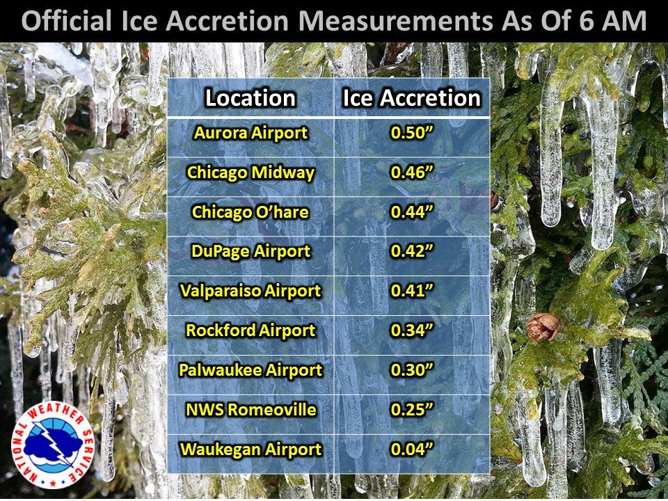
Not terrible out. Coating of snow providing traction on most surfaces plus temps aiding in melting. LOT calling for 1-2 inches of snow with high winds later today after a .25 of ice put us in a wind advisory after the ice storm warning expires. Hopefully some melting before the wind kicks in.
-
^
yup. I'm thinking we might get the ice we didn't get last week. With that wind could be in for more tree damage.
-
 1
1
-
-
9 minutes ago, ConvectiveIA said:
Hmm. No backside heavy snow before it ends?
potential for an inch or two as it pulls out.
-
 1
1
-
-
starting as sleet. Not a good sign, as I'm guessing we go to freezing rain next....
-
 1
1
-
-
5 minutes ago, ILSNOW said:
Good LOT update 3-6 from I-88 north with additional 1-2 tomorrow from wrap around snows.
to me, if the weather discussed in the AFD comes to fruition we'll have an upgrade to a warning in these parts by the late evening update if trends play out. Of course, advisory vs. warning is all just wording to me. Though I suppose the designation is important in communicating to the general public. Just read the updated forecast for Dupage (which is mostly north of I-88)and it differs somewhat from the AFD: 1-3" with .10 of ice. No anticipated trowal accumulations tomorrow despite the AFD stating concens for a couple of additional inches. Little bit of disconnect between the actual zone forecast and the AFD...but I'm sure it's hectic.
-
16 minutes ago, weatherbo said:
For anyone curious
.thumb.png.6584d9da578f788a747d278b621a758e.png)
.thumb.png.43bc89a2a9cd6db8f6408a7928feafcd.png)
snowier this way than other models...3-4". Wonder how much Ice to go with that?
-
wow. gone in the span of 24 hours.
-
1
-
-
12Z NAM sure looks icy around here.
-
7 minutes ago, Cary67 said:
Not a good look for Chicago area.
it's exactly what the forecast is. 1" south with Freezing rain to 6" up your way. Looks fine.
-
1
-
-
11 minutes ago, HillsdaleMIWeather said:
18Z GFS is a touch north
looks snowier in these parts
-
^
looks like that map was created at 2:41 am. Not sure if any changes are necessary.
-
Looks to me like both the 6Z NAM and GFS went south as well.
-
4 minutes ago, Hoosier said:
GFS has a secondary deformation feature. Doesn't produce much verbatim but keep an eye on it I guess if you're looking for flakes farther south.
am i correct in being somewhat disappointed in tonight's early runs?
-
Trends are weak,south, progressive tonight via models. Looks like another nuisance event.
-
^ I'm riding that and the Canadian for this one.
-
20 minutes ago, Maneee said:
Yeah really starting to wonder if we will get a large snowfall, the good news is if we don’t it won’t be for a lack of good systems. Strong winds on the backside will be fun either way.
never been a big wind guy myself.....

-
2
-
1
-
-
49 minutes ago, Cary67 said:

Your plots make it look more normal. On Pivotal's map it appeared to from E/Central Ill due north. Yep, another consistent track over us. Not good for a decent snow.
-
^
Bizzarre. If I'm seeing things correct comes E/SE into central Il. and than heads due north?
-
^
The trend has been for all of these storms to track over or just north of Chicago. Until you see a marked change in the pattern that's probably the way to go. Hope here is there is enough residual cold air to get some front end WAA snows prior to the change to Ice/Rain. And than a change that starts to get these storms tracking through the O/V from mid February-Mid March.
-
1
-
-
1 hour ago, whoosh said:
Monday ... evening rush ... that truck stop on I-80
best post of the new year. No surprise.
-
1
-
-
9 minutes ago, Hoosier said:
Surface low goes over Chicago on 12z Euro.
haven't seen a precip plot, but thinking that's still a decent hit for us given the movement of the low pressure E/SE out of the plains into W/C Illinois and than heading NE
-
Canadian is my model of choice here.
.png.b11c7dcc390962428efb30ec99154b11.png)
.png.109f0d4595448b4d16ea6144c826593e.png)

Winter Storm - February 11-13, 2019
in Lakes/Ohio Valley
Posted
They were both right. There should be much appreciation. The forecast was clearly wrong, and it should have been clear by 7:30 PM that freezing rain in a good chunk of the area was going to be the predominant precip. type. Odd thing is as I pointed out yesterday there discussion points hit on the potential hazards but didn't translate to the actual forecast. Granted, it was a complicated call for sure. But even today, a wind advisory when they are calling for 1-2 " of afternoon/PM snowfall with 35 mph wind gusts/blowing snow with minimum .25 ice on trees maybe underdoing the potential hazards.