

Baum
-
Posts
4,187 -
Joined
-
Last visited
Content Type
Profiles
Blogs
Forums
American Weather
Media Demo
Store
Gallery
Posts posted by Baum
-
-
there is an 8"-12" storm lurking....even in the worst of winters............
-
if it's the 18Z NAM that's exactly what you want to see.
-
 2
2
-
 4
4
-
-
14 minutes ago, A-L-E-K said:
DAB+
isn't that a can't miss?
-
^
at some point you would think this two year pattern of weak sheared events that fade as they get near would end........maybe this is the pattern breaker. Got to end at some point.
-
1
-
 1
1
-
-
legit heavy snow....
-
3
-
-
coming down nicely again...wind has been a non factor.
-
Decent rates. Quick ground cover. Looks like it will play out as called.
-
12 minutes ago, hawkeye_wx said:
A ridiculous band of snow pushed through SD/MN overnight, producing up to 3"/hr. There are totals of 12" in a narrow band through Minnesota, including Mankato, while across the border in South Dakota up to 16" fell. Why can stuff like this never happen here?
We are getting rain/sleet this morning.
karma. I fully expect this to happen IMBY today.

-
1
-
-
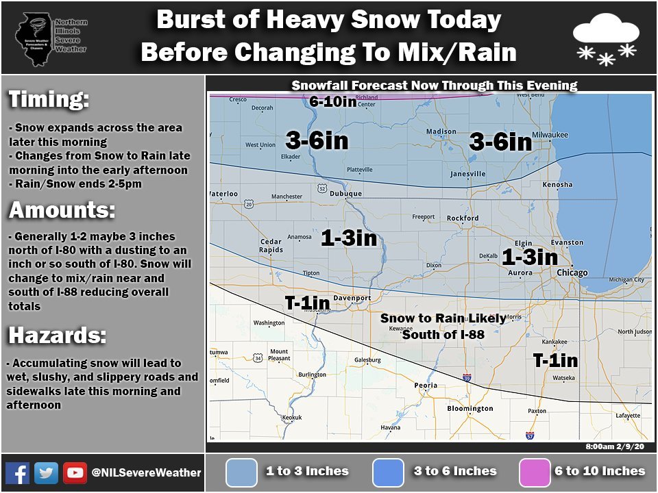
LOT in subtle walk back mode:...WINTER WEATHER ADVISORY IN EFFECT UNTIL 3 PM CST THIS
AFTERNOON...
REST OF TODAY
SNOW LATE IN THE MORNING, THEN SNOW AND DRIZZLE
IN THE AFTERNOON. PATCHY FOG IN THE AFTERNOON. SNOW MAY BE HEAVY
AT TIMES. NEW SNOW ACCUMULATION OF 1 TO 3 INCHES. TOTAL SNOW
ACCUMULATION 1 TO 5 INCHES. HIGHS IN THE MID 30S. SOUTH WINDS
10 TO 20 MPH WITH GUSTS UP TO 30 MPH. CHANCE OF MEASURABLE
PRECIPITATION 100 PERCENT.......
-
12 minutes ago, StormChaser4Life said:
Punt. Next. There's the midweek system at least. Going to forecast a dab at this time
according to this you really weren't in line for much....
-
AREA FORECAST DISCUSSION
NATIONAL WEATHER SERVICE QUAD CITIES IA IL
811 AM CST SUN FEB 9 2020
UPDATE
ISSUED AT 805 AM CST SUN FEB 9 2020
SATURATION HAS NOT YET RESULTED IN A WIDESPREAD SNOW EVENT, AND
TEMPERATURES ARE IN FACT WARMING ALOFT, QUICKLY. THE SURFACE
WETBULB 32 IS ALREADY FOUND ALONG AN AXIS FROM NEWTON IA, TO
MUSCATINE TO MACOMB. SOUTHWEST OF THIS LINE, WINTER IMPACTS WILL
BE EITHER NON EXISTENT, OR VERY SHORT TERM. FATHER NORTH, ALONG
I-80, WE ARE SEEING NARROW F-GEN BANDS OF MODERATE MIXED SNOW AND
SLEET, WITH SOME RAIN AND DRIZZLE IN BETWEEN. THAT SHOULD
TEMPORARILY SWITCH TO MODERATE TO HEAVY SNOW, AS THE COLUMN COOLS
DUE TO EVAPORATION AND DYNAMIC LIFT. HOWEVER, THE INTENSE WAA WILL
WIN OUT BY LATE MORNING, RESULTING IN A SWITCH TO RAIN AND
DRIZZLE. OUR HEADLINES CERTAINLY REPRESENT THE AREA MOST LIKELY TO
SEE MORE THAN ONE OUR OF ACCUMULATING SNOW IN THIS PROCESS, AND
WILL KEEP THEM IN PLACE UNTIL +32 WETBULB TEMP AND SNOW LIFT
NORTH OF OUR AREA TODAY
-
place under a WWA. LOT with a great write up this AM....just a sampling:HAVE SEEN PERIODIC GLM LIGHTNING FLASHES AND EVEN
A FEW CLOUD-TO-GROUND LIGHTNING STRIKES DETECTED, SIGNS OF THE
IMPRESSIVE DYNAMICS ASSOCIATED WITH THIS ROBUST HYBRID CLIPPER
SYSTEM.-
1
-
-
THE ECMWF SUITE OF GUIDANCE HAS BEEN THE MOST
CONSISTENT WITH THIS THREAT, WHICH CONTINUED ON THE 00Z CYCLE,
INCLUDING GOOD ENSEMBLE SUPPORT. PREVIOUS HOLDOUT GFS SUITE
TRENDED STRONGLY TOWARD THE ECMWF WITH THE 00Z CYCLE. THE MEAN
SOLUTION OF THE GFS AND ECMWF ENSEMBLES BRINGS ITS BROAD SNOW
SWATH OVER THE CWA, WITH THIS LIKELY BEING FROM A DEVELOPING
DEFORMATION AREA BASED ON THE GENERAL ENSEMBLE MEMBER SURFACE LOW
PLACEMENT. ....LOT AM AFD on the potential. If 12Z holds might be thread time.
-
35 minutes ago, CheeselandSkies said:
After hemming and hawing for several days due to model variability...SPC went ahead and dropped a big old Day 4 30% for Dixie Alley...and it wasn't Broyles!
huh?
-
glad I checked in. Let's get this done, and I'll take the early spring. Euro stays on course...who starts the thread?
-
2
-
-
SUNDAY
SNOW IN THE MORNING, THEN SNOW OR LIGHT RAIN OR DRIZZLE
LIKELY IN THE AFTERNOON. PATCHY FOG IN THE AFTERNOON. SNOW MAY BE
HEAVY AT TIMES IN THE AFTERNOON. SNOW ACCUMULATION OF 1 TO
2 INCHES. BLUSTERY. HIGHS IN THE MID 30S. SOUTH WINDS 15 TO
25 MPH WITH GUSTS UP TO 30 MPH. CHANCE OF MEASURABLE
PRECIPITATION 100 PERCENT. ..... TYPO ..happens-
3
-
-
"THE HIGHEST SURFACE WINDS OVERLAP THE PERIOD MOST FAVORED FOR
EFFICIENT SNOWFALL RATES. THESE ELEMENTS COMBINED ARE WHY
CONFIDENCE IS HIGH ENOUGH ALREADY TO INCLUDE 1/2SM SN MENTION IN
THE TAF."...LOT 18Z Aviation discussion-
2
-
-
23 minutes ago, Hoosier said:
I would take RC's post farther and say that I wouldn't be surprised to see a period of blizzard/near blizzard conditions in the LOT cwa. You need 3 hours of meeting the visibility and gust criteria which may be tough to do at any given location, but nonetheless it should be pretty intense for a while. There is tremendous low level wind in the waa regime, a lot of which should have trouble mixing down but still enough for some 35+ mph gusts I think. Also will be curious to see what happens with the winds if that heavy burst of snow materializes... whether it enhances the gusts or not.
if this were the case LOT would have to consider a WWA, although I guess RC mentioned the rare SSA(snow squall advisory
") )...looks like Izzi is in the house. If anybody would pull the trigger on that it'd be him.
)...looks like Izzi is in the house. If anybody would pull the trigger on that it'd be him.
-
^
no use bellyaching about a 2-3" potential in a winter like this
-
22 minutes ago, RCNYILWX said:
Top 5 most interesting event of the winter if it pans out lol
Sent from my SM-G965U using Tapatalk

-
41 minutes ago, Cary67 said:
Not sure systems in December were weak fades.Seems we had several decently strong rainers come through
December was dry as a bone...minus the system that scooted through St. Loius and Indy. In my mind, we have not had a true amped storm that wraps up in the winter season in almost two seasons. NAM looks better on this event it seems. Hoping for a 2-4" event...pipe dream I'm sure...
-
2
-
-
4 minutes ago, RogueWaves said:
^ last minute N bump in a mild winter. Shocking!
reality....the usual trends have been weak fades to the south...not saying that would be the case here.
-
1
-
-
^
i have no issue with an ealry spring meaning consistent 50's and 60's beginning in March. But it never works out that way...climo, I guess.
-
1
-
-
6 minutes ago, michsnowfreak said:
Ill take the 00z nam.
your in SE Michigan....does nothing for me. Though, I'm good for anyone else scoring.
-
2
-
1
-
Feb 12-13 Snowstorm
in Lakes/Ohio Valley
Posted
There ya go!