stormy
-
Posts
1,994 -
Joined
-
Last visited
Content Type
Profiles
Blogs
Forums
American Weather
Media Demo
Store
Gallery
Everything posted by stormy
-
18z GFS doubles my snow from 5 to 10 inches. The front end thump is intense with the 18z.
-
If the trailing wave becomes the storm would that push the height of the storm into Sunday?
-
I smelled a rat 24 hours ago when I said the GEM was beginning to focus on what the EURO was only sniffing at. Now, the GFS, GEM aand ECM all sense potential significant flaws with the idea of a major winter storm. Thermals are a problem and this system seems to be losing the ability to really crank! The GFS has cut the qp in half for my area and dropped the snow from 14 to 5" in one run. The ECM drops from 12 to 8 ", but the GEM increases from 2 - 8". This can still be a beast if the coastal bombs over Va. Beach and additional cold air is wrapped in from the north. I believe the models will hone in on a solution by Thursday afternoon.
-
Jan Medium/Long Range Disco: Winter is coming
stormy replied to stormtracker's topic in Mid Atlantic
This is a classic track from the 60's!! -
Jan Medium/Long Range Disco: Winter is coming
stormy replied to stormtracker's topic in Mid Atlantic
1028 HP north of Superior is diving S.E. faster. -
Jan Medium/Long Range Disco: Winter is coming
stormy replied to stormtracker's topic in Mid Atlantic
12 z GEM warms the 850 temp. from minus 5 to plus 1 from 00z to 12z over Augusta, Sat. 7 pm. 24 hr. qp drops from 1.28 to .81. A little concerning but an outlier at this juncture. The 12z Euro keeps us in pay dirt but the margin of safety is shrinking as the 850 & 925 warms a few degrees on the 12z compared to 00z early Saturday night. Is the GEM focused on a trend that the EURO is only beginning to sniff. The 18z GFS may be important. -
Jan Medium/Long Range Disco: Winter is coming
stormy replied to stormtracker's topic in Mid Atlantic
Amen -
Jan Medium/Long Range Disco: Winter is coming
stormy replied to stormtracker's topic in Mid Atlantic
Out here in the Valley, that has been my observations since the 60's. The first killing frost in the fall is now often 3 - 4 weeks later than the 60's. Late October compared to late Sept. In the spring the last killing frost is often 3 - 4 weeks later than the 60's. Mid May compared to late April. -
Best spot for snow vacation home within 4 hours of NOVA
stormy replied to SnowenOutThere's topic in Mid Atlantic
This is a no brainer! Anywhere west of the Allegheny Front in West Virginia is great. NOAA says snow falls in Elkins more days of the year than any other reporting station east of the Mississippi. Stay away from those Ski Resorts unless you have a couple million to throw away. Always keep in mind elevation. -
Jan Medium/Long Range Disco: Winter is coming
stormy replied to stormtracker's topic in Mid Atlantic
They usually have a much sharper perception than humans. Humans are too consumed in knowing when the next 384 hour ensemble or 7 month model is coming in. -
Jan Medium/Long Range Disco: Winter is coming
stormy replied to stormtracker's topic in Mid Atlantic
Whether its the 4th or 7th or the 13th. The amount of gloom is amazing. 50 years ago before all the nonsense with models, folks didn't worry about all of this crap, and it occasionally snowed. The historical sweet time has always been Jan. 15 to Mar. 15. Considering all the possibilities I don't believe we will be disappointed. Many will be hilariously happy with 5". We don't need 18 inches. -
I was disappointed to receive only .52". A definite underperformer from the modeled 1.60" on Monday.. But, happy that December produced 189% of normal at 4.91". Hopefully the STJ will stay active the rest of the winter and continue delivering above normal precip. Our water table has came up around 5 feet, still 17 ft. below April.
-
Jan Medium/Long Range Disco: Winter is coming
stormy replied to stormtracker's topic in Mid Atlantic
Comparing modern times to the 60's can be risky. My detailed records reveal a high of 65 for Christmas day of 1964 and 63 for Christmas day of 1965. January of 1966 began with a cloudy, showery Jan 1 with a high of 56. -
Jan Medium/Long Range Disco: Winter is coming
stormy replied to stormtracker's topic in Mid Atlantic
The historic Jan. 66 blast didn't begin until Jan. 22. During the next 2 weeks we had nearly 40 inches of snow. Everybody needs to settle down and be patient! -
Jan Medium/Long Range Disco: Winter is coming
stormy replied to stormtracker's topic in Mid Atlantic
You are 100% correct!!!!!!! -
Jan Medium/Long Range Disco: Winter is coming
stormy replied to stormtracker's topic in Mid Atlantic
I'm fine with you Cape. I believe you are 20/20. -
Jan Medium/Long Range Disco: Winter is coming
stormy replied to stormtracker's topic in Mid Atlantic
The main reason "this place needs a lift' is because it is almost incessantly told how bad everything is. -
Jan Medium/Long Range Disco: Winter is coming
stormy replied to stormtracker's topic in Mid Atlantic
Historically, Jan. 15 - March 15 for my area. I don't consider the snow season over until April 10. Several 6+" snows in early April last 50+ years. -
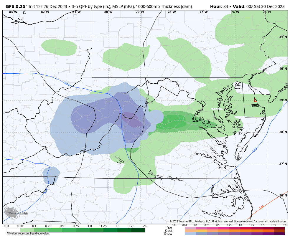
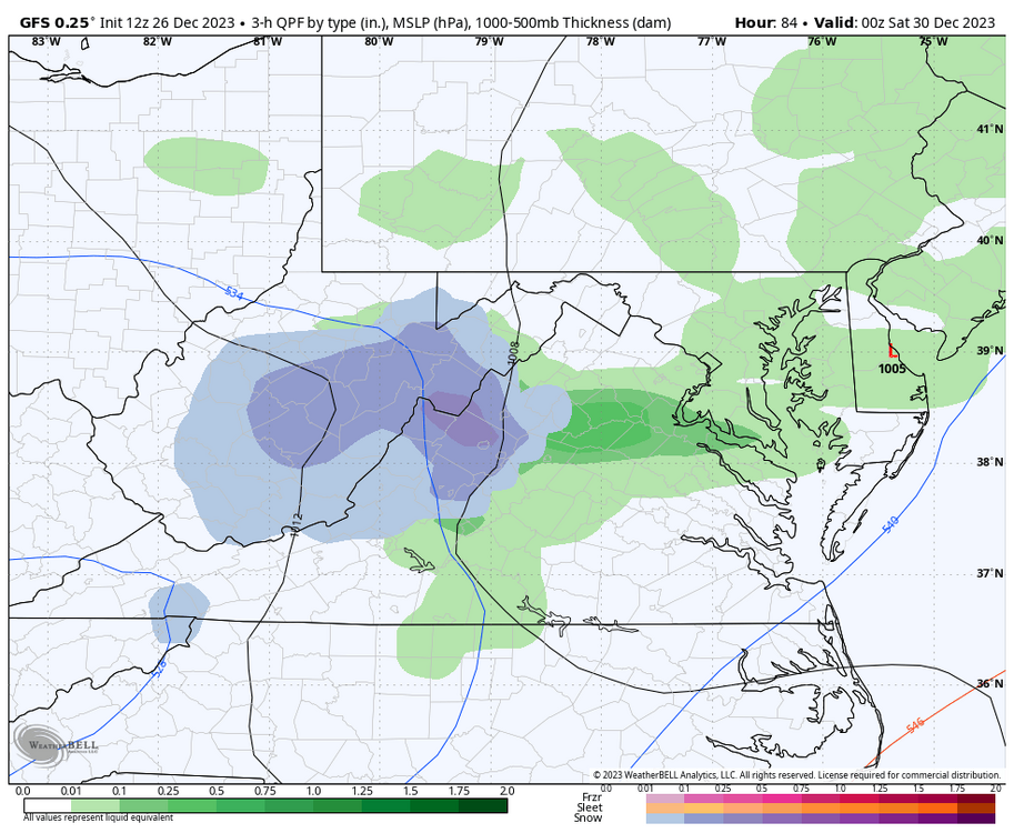
As modeled by the GFS, the Jan. 2 system only degrades for wintry potential with the 12z run. Pre-storm east and southeast surface winds bring in mild air off the Atlantic. Surface temps. are too warm for snow nearly everywhere below 3000 ft.. Even the 81-corridor where snow is painted would more likely be a sloshy mix. The winners would be the western mountains above 2000 ft. This is only my opinion based on the 12z run.
-
On Sunday afternoon I said, "Don't be too quick to give up on Friday". The 12z GFS now agrees: Only a snapshot in time, but we'll see.
-
At 192 that low is at least 75 miles too far north/northwest for D.C..... It should be closer to Cape Charles.. That type of track would be ok for west of the Blue Ridge.
-
Merry Christmas!!!!!!
-
Don't be too quick to give up on Friday. The Midwest gyre gives many of us soaking rain on Tuesday and Wednesday. As the upper level energy moves across Virginia on Friday, timing and a little more consolidation could give some areas a snowfall similar to Dec. 11. Only a weak surface reflection offshore and no real source of cold air to draw from tend to stack the deck, but this system carries adequate cold air. Slow it down and add a little more juice could turn the trick, something like planting surface LP over Norfolk at 10 pm Friday.
-
Wow!! Both the ECM and GEM give much of Augusta County 2 inches of rain during the next 168 hrs.. This Nino is producing. Many Valley folks have been praying for a wet Winter. December is making a solid contribution.
-
Yesterday afternoon, the 18z GFS op. made some flawed assumptions IMO that culminated in a major snowstorm for our region around Jan. 6 - 7. IMO, a very erratic track would not survive the test of time and I so stated my opinion. It did not survive the test of time. Period, Stop The period between Dec. 28 - Jan. 10 should be active and produce some snow for most of us. I believe most of us agree or at least hope for this reality. Accurate details are not available at this early date. Early speculation will likely change, but that is ok for those who wish to speculate. I will not criticize those who throw cold water on my ideas. Everyone is entitled to an opinion. Enjoy your life and now I begin a busy day.