PhiEaglesfan712
-
Posts
1,326 -
Joined
-
Last visited
Content Type
Profiles
Blogs
Forums
American Weather
Media Demo
Store
Gallery
Everything posted by PhiEaglesfan712
-
Blizzard of 2026 Storm Thread/OBS
PhiEaglesfan712 replied to Mikeymac5306's topic in Philadelphia Region
2009-10 was technically a strong el nino, as it went above 1.5 on both the ONI and RONI. So our last moderate el nino was 2002-03. -
Blizzard of 2026 Storm Thread/OBS
PhiEaglesfan712 replied to Mikeymac5306's topic in Philadelphia Region
Can see that happening. If that does happen, I could see 12-20 inches as far west as the I-95 metro area. -
Blizzard of 2026 Storm Thread/OBS
PhiEaglesfan712 replied to Mikeymac5306's topic in Philadelphia Region
Can definitely understand. Until there is actually snow on the ground, there is always bust potential. (March 2001 should have taught us that.) I just learned over time to be grateful for all types of weather as they come to you because you just never know when that's going to come again. Sorry if I do come across the wrong way. I kind of feel like an outsider, if anything, as I'm not a meteorologist or anything. I hold a full time job, and do this just for a hobby/interest. I don't get anything extra if my forecast verifies. -
Blizzard of 2026 Storm Thread/OBS
PhiEaglesfan712 replied to Mikeymac5306's topic in Philadelphia Region
He's trying to say I was debbing, but there is no proof of it. I said this looks a coastal storm, with those on the coast getting the most accumulation. I don't know why @The Iceman is disagreeing. -
These people have to be under adult age. I can understand if our last snowiest winter was some time during the 20th century, but who could forget about 2009-10, 2010-11, 2013-14, or 2014-15? Those were at least recent enough that people should remember how cold and snowy they were.
-
Blizzard of 2026 Storm Thread/OBS
PhiEaglesfan712 replied to Mikeymac5306's topic in Philadelphia Region
Sounds about right, but of course this isn't the popular opinion on this board. It seems like everyone wants to hear 10+ throughout the region. -
Blizzard of 2026 Storm Thread/OBS
PhiEaglesfan712 replied to Mikeymac5306's topic in Philadelphia Region
A cross between 12/26/2010 and 1/28-29/2022 seems the most likely solution. -
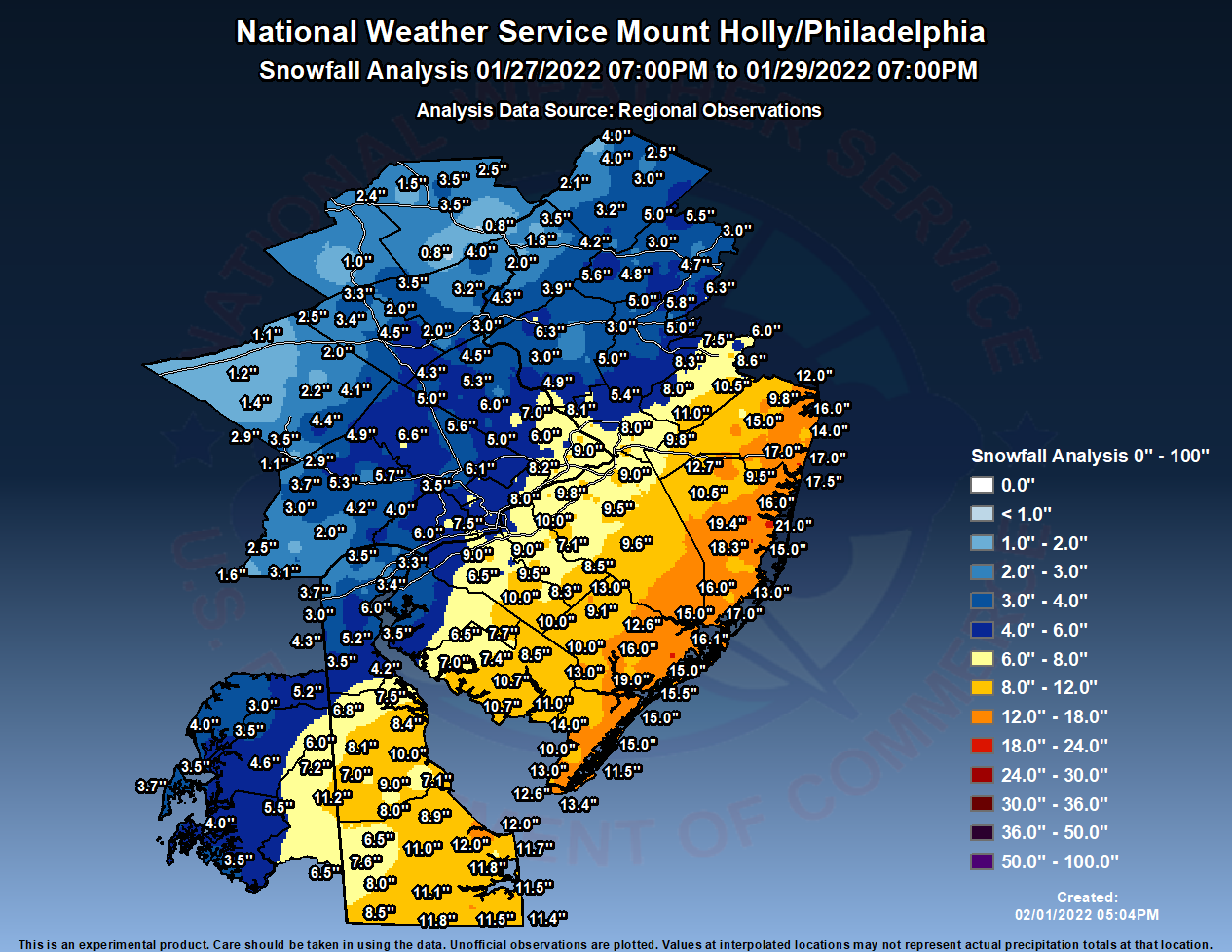
I think a cross between this one and the January 28-29, 2022 snowstorm.
-
E PA/NJ/DE Winter 2025-26 Obs/Discussion
PhiEaglesfan712 replied to LVblizzard's topic in Philadelphia Region
Are you sure there's still slush, or is it mud? I was in a winery at Voorhees, and can confirm that the snow on the grass is gone, and it is just mud now. -
Blizzard of 2026 Storm Thread/OBS
PhiEaglesfan712 replied to Mikeymac5306's topic in Philadelphia Region
I caught, in passing, 101.5 saying 12-20 inches in some parts on NJ. -
Blizzard of 2026 Storm Thread/OBS
PhiEaglesfan712 replied to Mikeymac5306's topic in Philadelphia Region
I see a coastal storm, with the higher amounts towards the coast. It looks really close, almost to the amounts.
-
Blizzard of 2026 Storm Thread/OBS
PhiEaglesfan712 replied to Mikeymac5306's topic in Philadelphia Region
Looks like January 28-29, 2022 all over again. -
E PA/NJ/DE Spring 2026 Obs/Discussion
PhiEaglesfan712 replied to PhiEaglesfan712's topic in Philadelphia Region
I'm tracking it. I was just answering that person's question. I was just in the office yesterday because I actually have to do work, so I didn't have time to post on the Blizzard thread. I have posted on there in previous days, like Monday, Tuesday, and Thursday. Nope, it's going the way I had predicted it. I did say there was a possibility of one big snowstorm during the final week of February, before the winter went away for good in the last days of February/first days of March. I always prefer 80 and sunny, like 3/29/2025. I realize it's just not going to happen all the time. Some days it's going to be hotter, and some days it's going to be colder. But some months have an obvious cold signal and you know are going to be cold heading into it, like this month or March 2015. But just be aware that things do eventually swing the other way. Some of our coldest winters, like 2010, 2011, and 2015, had torch months during the spring. March 2010, April 2010, May 2010, April 2011, May 2011, and May 2015 are all Top 10 warmest months. Do not be surprised if one of this spring's months turn out very warm. -
E PA/NJ/DE Spring 2026 Obs/Discussion
PhiEaglesfan712 replied to PhiEaglesfan712's topic in Philadelphia Region
Probably not, but temps should be in the 40s or 50s during that week, maybe even a 60. We should see a 70 at some point in the middle third of the month. -
E PA/NJ/DE Spring 2026 Obs/Discussion
PhiEaglesfan712 replied to PhiEaglesfan712's topic in Philadelphia Region
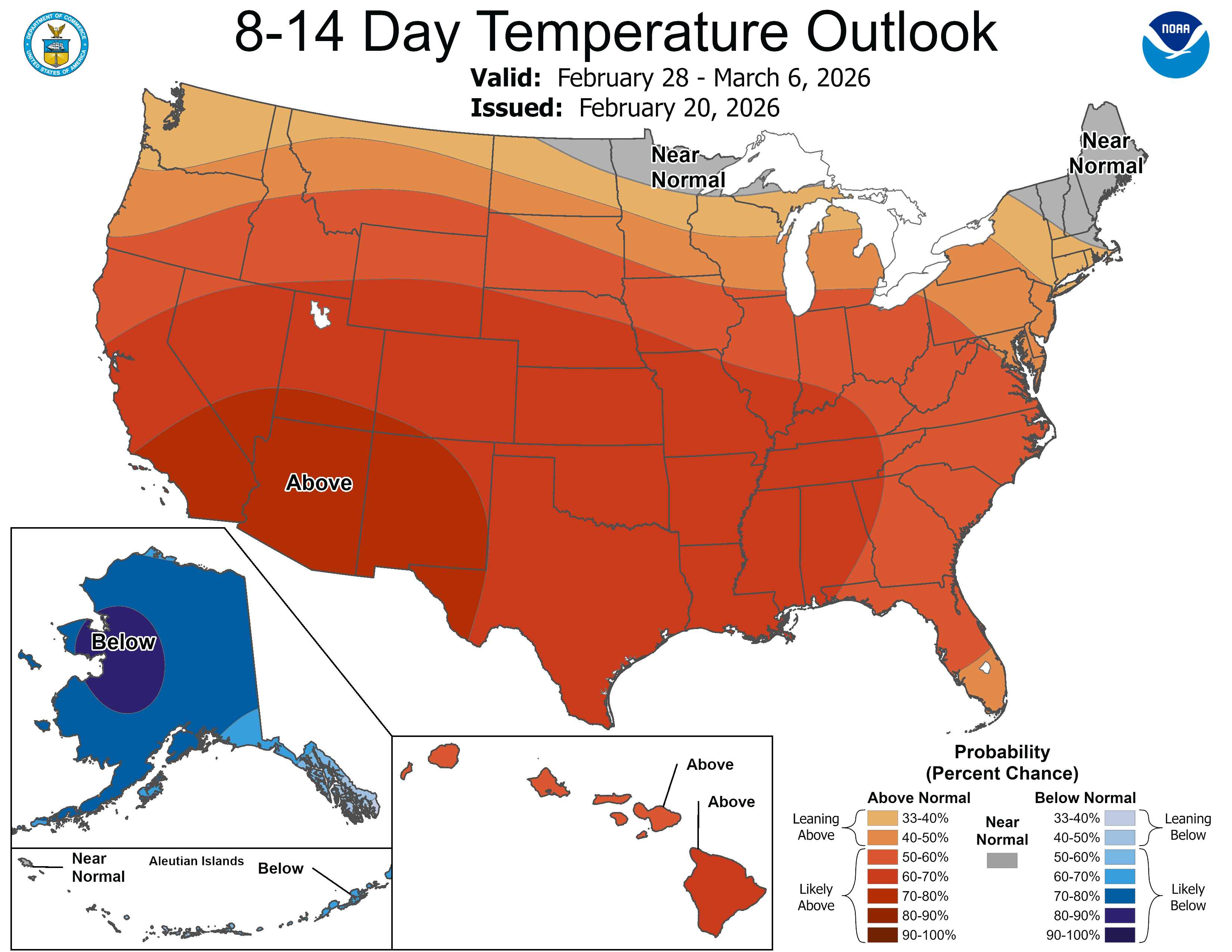
New maps show first two-thirds of March warm: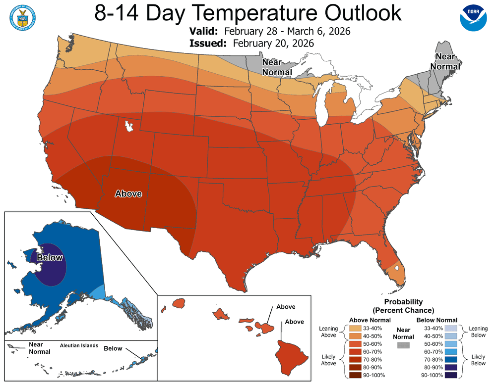
-
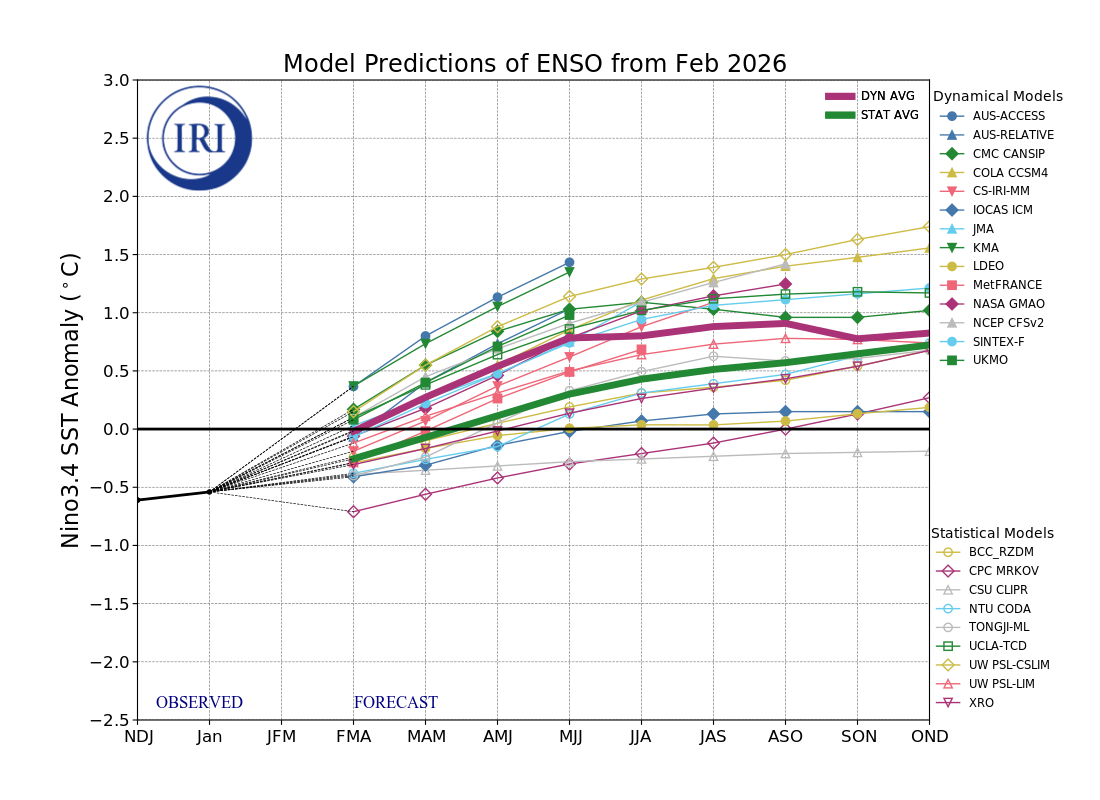
2026-2027 El Nino
PhiEaglesfan712 replied to Stormchaserchuck1's topic in Weather Forecasting and Discussion
-
February 2026 OBS & Discussion
PhiEaglesfan712 replied to Stormlover74's topic in New York City Metro
Above temperature departure seems like a lock. We're in a dissipating la nina, and headed into MJO Phase 4 after this weekend's event. Plus, there is very little cold air to work with. These ingredients set the stage for a warm first half of March at least. -
Late February/early March 2015 comes to mind. Although, things turned warmer as the spring went on. May 2015 was near record warm. NYC Feb 2015: 23.9 -12.0 Mar 2015: 38.1 -4.7 Apr 2015: 54.3 +0.6 May 2015: 68.5 +5.3 I won't be surprised if one of the spring months was near record warm.
-
E PA/NJ/DE Spring 2026 Obs/Discussion
PhiEaglesfan712 replied to PhiEaglesfan712's topic in Philadelphia Region
No, that was just the snow getting slushy and melting. My sister and I went for a walk on Monday afternoon. Someone didn't clean their pathway, so my sister walked slowly and carefully on it because she didn't want to get her sneakers dirty. -
Blizzard of 2026 Storm Thread/OBS
PhiEaglesfan712 replied to Mikeymac5306's topic in Philadelphia Region
I'm starting to think February 23, 1987 is a good analog for this storm. -
E PA/NJ/DE Winter 2025-26 Obs/Discussion
PhiEaglesfan712 replied to LVblizzard's topic in Philadelphia Region
The problem with this is that there is limited cold air and the sun angle. It will likely be all rain, that is if we even have precipitation. -
There's always next winter. I just hope the PDO turns positive, more so than an el nino.
-
E PA/NJ/DE Winter 2025-26 Obs/Discussion
PhiEaglesfan712 replied to LVblizzard's topic in Philadelphia Region
It feels like curtains on the winter. With the sun angle increasing, it's only going to get tougher to get the cold air necessary for a snowstorm. -
E PA/NJ/DE Spring 2026 Obs/Discussion
PhiEaglesfan712 replied to PhiEaglesfan712's topic in Philadelphia Region
These will not verify. The problem is that there is limited cold air, and the increasing sun angle. I guarantee there will be more >60 highs than <40 highs during the first week of March. No way we see a temp of 25 at 1 pm on March 3 in NYC. That's like record low territory. -
E PA/NJ/DE Spring 2026 Obs/Discussion
PhiEaglesfan712 replied to PhiEaglesfan712's topic in Philadelphia Region
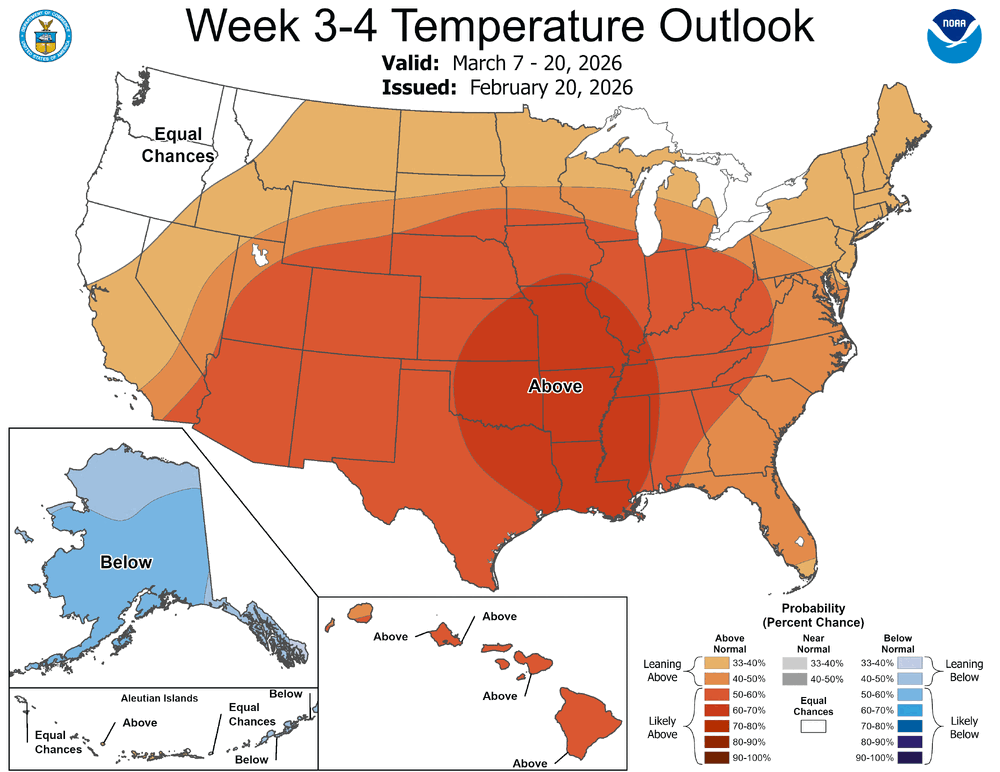
That's the most recent one. The 3-4 week gets updated weekly (on Fridays), so the next update is on Feb 20 (for March 7-20).