

09-10 analogy
-
Posts
1,215 -
Joined
Content Type
Profiles
Blogs
Forums
American Weather
Media Demo
Store
Gallery
Posts posted by 09-10 analogy
-
-
Seems like a little lull in at least the rain coming up, but it's action-packed back to the SW along and south of I-64.
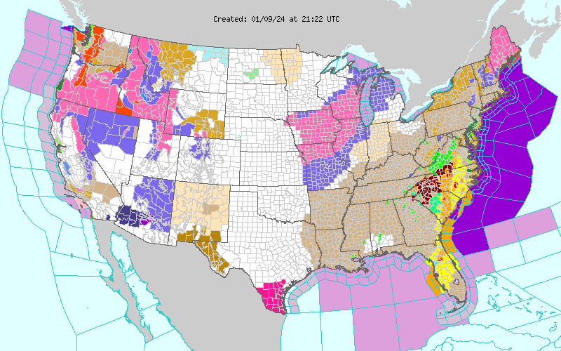
EDIT: Speaking of action-packed, quite a little severe outbreak going on in the Carolinas now. More or less unbroken line of STWs straight down from east of Charlottesville, down to Hilton Head and out to sea, then regaining land in Florida and stretching to Tampa Bay.
This is really a rather magnificent weather system.
-
 5
5
-
-
5 minutes ago, Eskimo Joe said:
For some reason that MDs citation of the "Sargasso Sea," with its reputation as being a mystically inescapable area, seems proper beyond the geospatial accuracy, for a day like today, with conditions right out of Shutter Island.
-
4 minutes ago, PrinceFrederickWx said:7 minutes ago, PrinceFrederickWx said:
I think the last time I saw this particular combination of advisories, watches and warnings was during Superstorm Sandy.
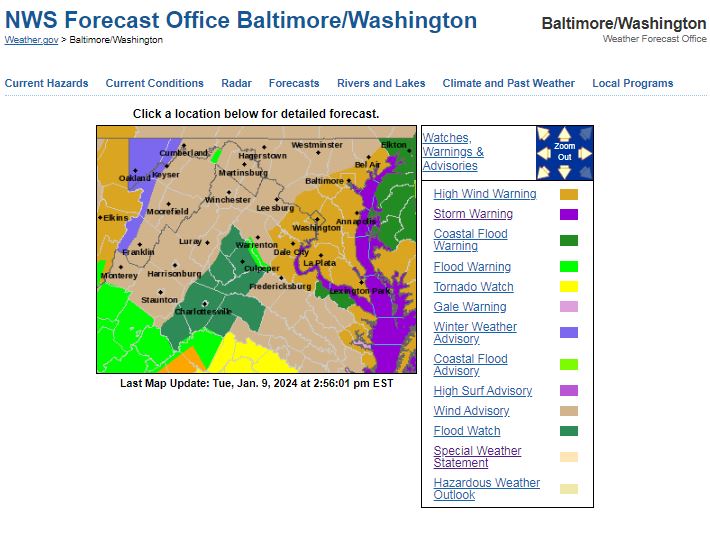
NW DC current has six hazardous weather statements: Coastal Flood Warning (not really applicable at 380' but what the hell, it's the same jurisdiction as Hains Point); Hazardous Weather Outlook; Special Weather Statement; High Wind Warning; Flood Watch; Coastal Flood Advisory (again, 380' and Hains Point).
This SWS is kinda cool, though:
...HAZARDOUS WEATHER CONDITIONS FOR BALTIMORE/WASHINGTON
REGION TODAY BETWEEN 500 PM AND 1000 PM EST...

Weather conditions will deteriorate as a strong frontal system
approaches this afternoon, then passes through the greater
Baltimore/Washington region this evening. This will result high
winds capable of downing trees and powerlines, tidal flooding, and
the potential for flooding of small streams and creeks. This
will create hazardous travel conditions late this afternoon
through late evening across the region.

Light-to-moderate rain will continue early this afternoon, then
increase in intensity late this afternoon, with a several hour
period of heavy, intense rainfall expected between 6 PM and 10 PM.
This heavy rainfall, coupled with already saturated soils from
recent rainfall, will cause flooding of small streams and creeks.
Do not attempt to drive across flooded roadways; additionally,
flooding at night increases the risk for motorists not being able
to quickly identify the water hazards due to decreased
visibilities by the heavy rain and darkness.

Easterly winds will increase in intensity as well this afternoon
across the region, with gusts to 50 MPH expected late this
afternoon through mid-evening. Locations closer to the Chesapeake
Bay will see higher wind gusts of 60-70 MPH. Strong winds will
increase the risk of falling trees and downed powerlines. Again,
the risk of poor outcomes resulting from high winds is increased
during nighttime. Winds will decrease after midnight tonight.

Finally, areas along the tidal Potomac River and western shore of
the Chesapeake Bay north of Smith Point VA should prepare for
moderate-to-major tidal flooding. The cities of Baltimore, Annapolis
MD, and Alexandria VA are most prone to tidal flooding, and the
coupling of heavy rainfall and strong onshore winds of 50-60 MPH
in these locations will work together to create moderate-to-major
tidal impacts.

Repeating, a strong frontal system will approach and pass through
the greater Baltimore/Washington region late this afternoon into
this evening. Small stream and creek flooding, tidal flooding,
and high winds will create hazardous conditions late this
afternoon through late evening. Motorists should expect hazardous
conditions in their evening commute, and should avoid unnecessary
travel. Prepare for the potential for power outages.
-
2 minutes ago, MN Transplant said:
Far more puddles than the previous storms over the past month. We really are saturated now in the top levels of the soil. Over an inch and plenty more on the way.
Yep, plenty of ponding action. And now the wires are beginning to sway in the wind.
Worst case scenario on the way: lose power while the basement gets standing water, so that I can't use the sump pump or water vac to try and stay ahead of it. Well, not worst case; that would be if I slip in my dark basement and hit my head and off myself. At least then I wouldn't have to have an extended date with my water vac.
-
 1
1
-
-
Definitely getting "stormier" now. Took a (wet) walk outside down to where the TV tower along Wisconsin Ave. is, and I can hear the dull roar of the wind as it passes through the top (around 700 feet up). But not really that windy at the surface (yet?). Always a good way to guesstimate what kind of wind energy is above ground level, I suppose.
-
2
-
-
3 minutes ago, yoda said:
Yup,.. damn
Strong Winds: An unprecedented LLJ is likely to develop over the
eastern half of the CWA Tuesday afternoon into Tuesday night as the
main surface low moves through. Current soundings from the GFS,
ECMWF, and NAM12 all have 50-70KT at 925mb, and 70-90KT at 850mb.
The evening sounding on Tuesday at IAD could break observed wind
records at 925mb, 850mb, and 700mb.
Pity this isn’t May with a 75/68 spread
-
5 minutes ago, Jebman said:
Mobile office writeup personnel were likely pretty groggy from watching models. Other than that, I am most assuredly JEALOUS AS ALL HELL!!!!!!!
Yeah the severe threat down there seems mostly mitigated to a certain degree by modest thermodynamics. But if that insanely powerful LLJ can push the warm front north far enough, it could be a real nasty outbreak in the New Orleans to Tallahassee area. And then the next day, the coastal Carolinas are under the gun, as well as Florida. This on top of the Gulf of Mexico acting like the North Atlantic during the The Perfect Storm.
I mean, hell, we're just getting another wind and rainstorm around here, so might as well live vicariously in other regions.
-
1
-
-
11 hours ago, Scarlet Pimpernel said:
I'd rather have a bottle in front'o'me than a frontal lobotomy! (Can't remember where I heard that from, but always thought it was funny!)
Tom Waits.
On another note, the Gulf is evidently going to be blasted by this storm. Maybe the worst non-tropical event in a long time. This AFD from the Mobile office is energetic reading:
-
2
-
1
-
-
Sheer genius.
Maybe we need a STEINER! model.
-
1 hour ago, Terpeast said:
I love Spain. Where did you go? I've been to Seville and Bilbao. Both cities are a total contrast from each other, really interesting. And during the afternoon siestas, entire cities go really quiet and almost nothing is open.
When I was at the Madrid airport about to leave, it started snowing. It was March.
Madrid then Seville and now Barcelona. Flying back tomorrow. Seville was charming but it was a bit like a theme park for Spanish culture and history lovers. The Moors and Magellan and orange trees. Madrid is huge and we were there over Xmas so prolly didn’t get the city’s normal vibe, but you can get Campari as easily as you can catch a cold in kindergarten. Royal Palace was pretty cool and reminded me that monarchies are only worthwhile in retrospect. *Barcelona is just fantastic but the Familia cathedral, one of the big sites (it’s never been finished), is, to me, an architectural schizophrenic: a gothic cathedral with eagles and fruit topping some of the spires. No can comprehende. But the city is glorious and can hold its own, IMHO, with some of the other big name European urbans that I’ve been to and loved . The Baleric/Mediterranean really adds cachet.
only regret was not seeing the Prada or “Gunerica” in Madrid, or the Picasso museum here. Holidays and long waits kibboshed those plans. Needed to get tickets in advance but didn’t. Another reason to always heed my wife’s advice.
jeez this post was long, particularly with the first real winter threat in two years looming. So apologies and if this needs to be deleted, understandable. At least it’s in banter.
*edit: Spain is still a constitutional monarchy I suppose, but it’s like the 384 hour GFS: not taken real seriously
-
1
-
-
Coming back from Spain Wednesday and will be depressed after a great trip. But the chance (emphasis) of a MECS over the weekend will help take the sting out. Doesn’t snow much in Barcelona. But what a great city!
-
3
-
-
Here we come Spain! 12 days in Madrid, Seville, and Barcelona. I was gonna rent a car in the latter and drive to Andorra and the Pyrenees -- I'd certainly see snow there -- but it's just not feasible. 3 hour drive each way and nowhere to park once you get to the postage stamp capital of the multiverse. But still playing with the idea of renting a car in Seville and going to Gibraltar. I want to see the coast of Africa and the only place in Europe they have monkeys (other than zoos, of course).
And, yes, we'll be on the lookout for Barcelona's notorious pickpockets.
-
5
-
-
I propose that slipping in the basement, as I just did, from standing water resulting from a near 3" rainstorm, should warrant an LSR to Sterling. After all, I could have landed on my head instead of my butt (since I was half asleep) and killed myself, and that would have had a direct cause-and-effect relationship with the elements.
-
2
-
-
3 hours ago, jacindc said:
I was in it on 95 in South Carolina and bailed over to a US highway. Between the deluge, the standing water, the stiff wind, and the idiots going 80, I opted for a slower-but-safer route. Finally started letting up around Brunswick, GA. Southern NC also has all that construction now. Ugly.
Sent from my Pixel 8 using Tapatalk
95 thru the Carolina is as dreadful a stretch of interstate there is. No scenery, lots more traffic than you would think. Done it many times and hate it evermore. Rt. 1 is (or was) somewhat nicer.
Meanwhile, rain. Almost carbon copy of last Sunday night except we won't get a surprise dusting around 3 this morning.
-
1
-
-
10 minutes ago, CAPE said:
You can feel the juice in this airmass. Ground, roads, cars all wet despite no precip falling.
50/48 currently.
When the word "damp" was first coined, it was on a day like today.
-
9 hours ago, pazzo83 said:
this is a triple phaser right?
Found a nice site on phasing storms (although I'm sure it's been posted before):
https://www.greatlakes.salsite.com/Phasing_Storms.html
-
1
-
 2
2
-
-
My wife's picking up my daughter at uni. Central NY was predicted 4-7". Hamilton got about the same kind of dusting I did.
Ha.
-
Did not expect this. Grass mostly covered, moderate snow (although lightening up now), some slight glazing on neighborhood streets.
-
1
-
-
Lots of folks might have seen this already, but here's a clip from one of last night's Tennessee tornadoes. 0:19 to 0:25 or so is not something you see everyday:
(Alert for a bit of *colorful* language; flagged because I'm not sure what this site's policy is on that.)
-
16 hours ago, Maestrobjwa said:
Where the frickle did this news pop up from? Oh shoot
 (And he's a Baltimore native too...hmmm!)
Well Rubenstein -- as noted -- was born in Baltimore so I imagine he wouldn't try to move them. From the admittedly threadbare article -- although Bloomberg is a very legit source -- I get the vibe he's just another filthy-rich guy (although is $4.6 billion even considered "filthy rich" these days?) who wants a plaything. But if he's hands-off and willing to spend to, say, extend Henderson and some of the other burgeoning stars, that's not so bad. Certainly better than John Angelos, whose tenure as O's all-but-in-name owner can't be terminated quickly enough.
-
Good to see we still do fog well around here.
-
1
-
-
BWI: 27.2"
DCA: 17.2"
IAD: 31.2"
RIC: 15.2"
Tiebreaker -- SBY: 9.2"
My front yard: 365.22" (actually 26.2")
-
1
-
-
3 hours ago, mappy said:
I am not sure if they will have a summary, here is their website: https://www.midatlsevere.com/
It is open to the public, tickets were reasonably priced. They will have it next year, trying to align it with AMS Severe Conference that is happening in VA Beach at the end of October, so their thought is to hold the event in Richmond following that AMS Conference nearby. I think October 26th 2024 was the date I saw, but that could change.
Thanks
-
On 11/4/2023 at 9:45 PM, mappy said:
Spent the day in Richmond attending the mid Atlantic severe weather conference. So much good weather research going on these days, and got to meet a lot of folks I’ve known from Twitter in broadcast meteorology and emergency management.
Sounds great, do you know if they will be posting a summary of proceedings?Can anyone attend, if they hold it next year?
Tuesday, January 9 Rain and Wind Storm
in Mid Atlantic
Posted
Some sun, some sun, my kingdom for some destabilizing sun.