

09-10 analogy
-
Posts
1,224 -
Joined
Content Type
Profiles
Blogs
Forums
American Weather
Media Demo
Store
Gallery
Posts posted by 09-10 analogy
-
-
Really good rates now. 5.5". 6" seems a lock. Can the ULL pass later get me over 8"?
-
4.75", with some pingering.
-
Legit rates back again. How long it will sustain, though?
-
Rates have definitely dropped off and a little sleet may be mixing. Hard to tell, if there is, it's lighter than a Zippo WW2 artifact. Eyeballing 4.5" plus or minus infinity.
-
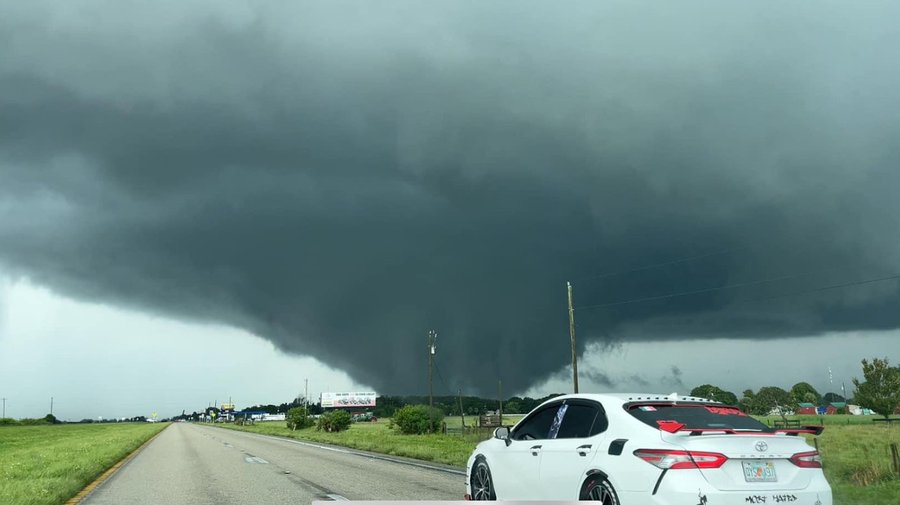
Several wedge tornadoes being reported in the vicinity of Lake Okeechobee. Lke this one
-
 1
1
-
-
After the Orioles' dreadful performance, another dank and dreary day would kinda fit my mood this morning.
-
14 minutes ago, clskinsfan said:
Hugo was a baby compared to this. Tiny little bitch
Hugo was 937 mb when it hit SC. Helene as of 5 pm was 951. It may surpass Hugo. But, still, comparable.
-
The comparisons to Hugo are pretty apt I think. Strengthening on the way in, booking along, and liable to hit a major metro area far inland hard.
EDIT: One thing I just thought of, Hugo didn't seem to have a big affect on the southern Appalachians? I mean, like Helene is gonna blast them with.
-
22 minutes ago, franklin NCwx said:
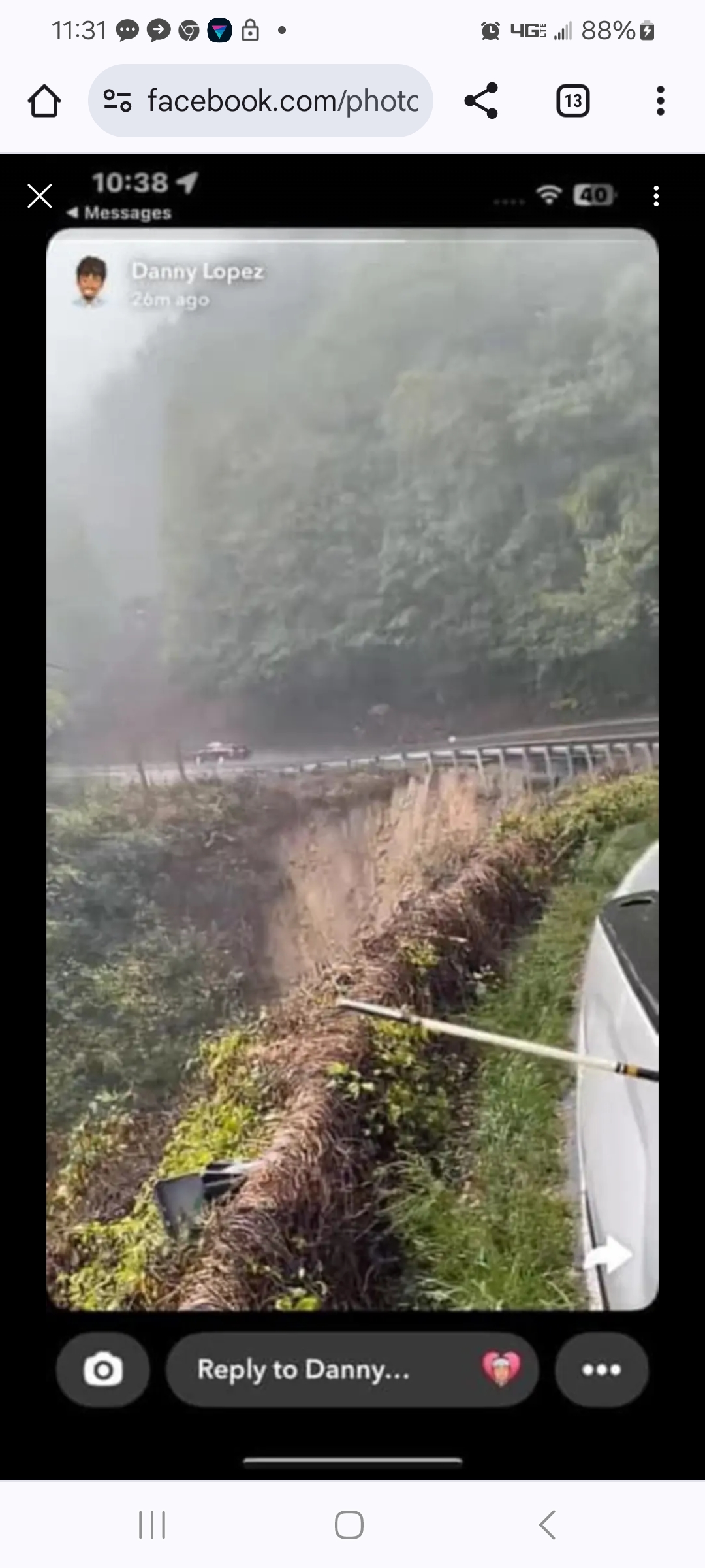
Hwy 106 between Dillard and Highlands is about to washout

If that's the road I'm thinking of, it's dicey in the best of circumstances. Couldn't pay me enough to travel on it now.
(I used to co-own some property in Highlands so I'm a bit familiar with the area.)
-
2 minutes ago, Kmlwx said:
Seems a little less dramatic than it looked earlier. But it was still coming down pretty hard on my morning Dunkin run.
I have an issue with water seepage in my basement, and am a firm believer in the superstition that if you mention something unpleasant enough, it won't happen, so every time there's a heavy rain, then like Pavlov's dogs, I drool "June 2006."
-
 1
1
-
-
36 minutes ago, Kmlwx said:
Hate to say it...but the radar this morning is giving me June 2006 vibes with the linear and look. It is POURING here right now. If there's not some dissipation or movement of the firehose - there's going to be issues this morning....
Yeah, usually this kind of overnight activity is one and done. This is the third period of heavy rain in an hour or so. I think this is related to the PRE to our south that's setting the table for the dangerous flooding in the southern Apps from the tropical system. I'd call it a PRE here but it seems decidedly uncertain at this point just how much of Helene's remnants affect the *immediate* DC weather.
-
Pretty heavy nocturnal rain shower in up nw. In fact, very heavy. Saw some flashes of lightning earlier but didn't hear thunder.
Used to own some property in Western NC, near Highlands. I would not want to be there for the next 48 hours. There are some rather hairy mountain roads around there; I can't imagine trying to negotiate them in the kind of conditions they're forecasting. And it's not too often you see Eastern WFOs talk about the possibilities of landslides.
-
11 hours ago, Scraff said:
Eflin looking great tonight. Offense looks good. D is solid. Liking it all this evening! Let’s Go Os!!!
He pitched an eflin good game.
-
9 minutes ago, nw baltimore wx said:
Good stuff, though I’d like to see some better defense rather than the recent sloppy infield play.
And I'd like to see the pitcher attrition rate diminish somewhat from that seen on the Western Front of WW1.
-
1
-
-
For all the dismay about the O's rather mediocre last month, according to Statcast, the 2024 O's rank number 8 in team offense *of all time*, according to the adjusted OPS+ metric.
https://stathead.com/tiny/ssGZd
Right there with the Big Red Machine from the 70s. Anthony is a big part of that.
-
2
-
-
Lots of small branches and leaf debris littering the streets around here. I guess those winds touching 40 mph earlier this morning made their mark.
-
1
-
-
Whiteout rain in up nw. Winds were gustier earlier this morning, though, around sunrise, when there was little rain to speak of.
-
1
-
-
Getting pretty ominous looking in up nw. I'd go out and try to find something, but a rainy rush hour in the midst of a major metro area isn't real condusive to chasing. And I don't want to get drenched going over to Fort Reno Park. Did that for Isaias and was decidedly underwhelmed.
-
1
-
-
BULLETIN - EAS ACTIVATION REQUESTED Tornado Warning National Weather Service Baltimore MD/Washington DC 748 AM EDT Fri Aug 9 2024 The National Weather Service in Sterling Virginia has issued a * Tornado Warning for... Southwestern Prince Georges County in central Maryland... North central Charles County in southern Maryland... Southeastern Fairfax County in northern Virginia... * Until 815 AM EDT. * At 748 AM EDT, a severe thunderstorm capable of producing a tornado was located 7 miles northwest of La Plata, moving north at 40 mph. HAZARD...Tornado. SOURCE...Radar indicated rotation. IMPACT...For those in the direct path of a tornado touchdown, flying debris will be dangerous to those caught without shelter. Damage to roofs, siding, and windows may occur. Mobile homes may be damaged or destroyed. Tree damage is likely. * This dangerous storm will be near... Fort Washington, Fort Hunt, Groveton, Fort Belvoir, and Hybla Valley around 755 AM EDT. Other locations impacted by this tornadic thunderstorm include Bryans Road, Mount Vernon, Hayfield, Potomac Heights, and Accokeek.-
1
-
 1
1
-
-
Just now, Kmlwx said:
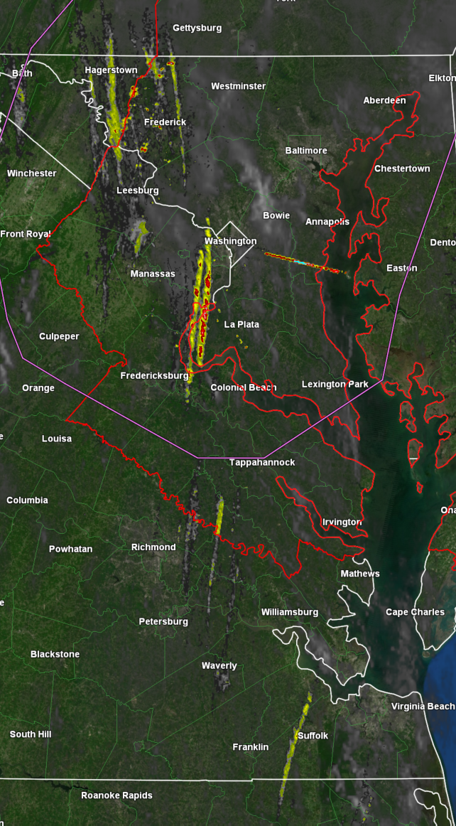
1hr rotation tracks

Nice ... where do you get that?
-
Still a good bit of SRH out there: patch of 300 0-3km right over DC, according to SPC hourly meso.
https://www.spc.noaa.gov/exper/mesoanalysis/new/viewsector.php?sector=17#
-
DCA gusted to 40 in the past hour and it's been similar here. Debby's remnants are windier than I thought they'd be.
-
Tornado-warned banding moving up 95 toward DC. (Well, warnings were around Richmond.)
Severe Weather Statement
National Weather Service Wakefield VA
449 AM EDT Fri Aug 9 2024

VAC033-090900-
/O.CON.KAKQ.TO.W.0030.000000T0000Z-240809T0900Z/
Caroline VA-
449 AM EDT Fri Aug 9 2024

...A TORNADO WARNING REMAINS IN EFFECT UNTIL 500 AM EDT FOR NORTH
CENTRAL CAROLINE COUNTY...

At 449 AM EDT, a severe thunderstorm capable of producing a tornado
was located near Port Royal, or near King George, moving north at 40
mph.

HAZARD...Tornado.

SOURCE...Radar indicated rotation.

IMPACT...Flying debris will be dangerous to those caught without
         shelter. Mobile homes will be damaged or destroyed. Damage
         to roofs, windows, and vehicles will occur.  Tree damage is
         likely.

This tornadic thunderstorm will remain over mainly rural areas of
north central Caroline County.


LAT...LON 3812 7722 3813 7730 3824 7730 3824 7729
      3823 7729 3822 7728 3825 7728 3825 7725
      3824 7723 3823 7725 3821 7724 3819 7725
      3819 7723 3820 7722
TIME...MOT...LOC 0849Z 185DEG 36KT 3819 7724

TORNADO...RADAR INDICATED
MAX HAIL SIZE...0.00 IN

$$

Miller
Tornado Warning VAC033-057-085-087-097-101-090915- /O.NEW.KAKQ.TO.W.0031.240809T0847Z-240809T0915Z/ BULLETIN - EAS ACTIVATION REQUESTED Tornado Warning National Weather Service Wakefield VA 447 AM EDT Fri Aug 9 2024 The National Weather Service in Wakefield has issued a * Tornado Warning for... Northwestern King and Queen County in east central Virginia... Southeastern Caroline County in north central Virginia... East central Henrico County in central Virginia... Northwestern King William County in east central Virginia... Southeastern Hanover County in central Virginia... West central Essex County in east central Virginia... * Until 515 AM EDT. * At 447 AM EDT, a severe thunderstorm capable of producing a tornado was located over Highland Springs, moving north at 60 mph. HAZARD...Tornado. SOURCE...Radar indicated rotation. IMPACT...Flying debris will be dangerous to those caught without shelter. Mobile homes will be damaged or destroyed. Damage to roofs, windows, and vehicles will occur. Tree damage is likely. * This dangerous storm will be near... Mechanicsville, Highland Springs, and East Highland Park around 450 AM EDT. Studley around 455 AM EDT. Mangohick around 500 AM EDT. Other locations impacted by this tornadic thunderstorm include Enfield, Central Garage, Owenton, Upshaw, Etna Mills, Penola, Sandston, Epworth, Richmond International, and Fair Oaks.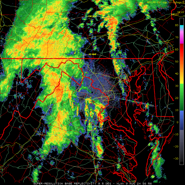
-
28 minutes ago, 87storms said:
Pretty healthy cg lightning nearby.
Just had the first real light-tower action in up nw.
Some gusty winds as an overture, but the T&L didn't start kicking in until 15 minutes or so after the heavy rain commenced.
-
1
-
January 5-6 Thing Storm Obs
in Mid Atlantic
Posted
This little band going over northern DC is rocking. May be letting up a wee bit now. Went out to shovel. Shoveling is much more enthralling when the snow is coming down legitimately.