

09-10 analogy
-
Posts
1,215 -
Joined
Content Type
Profiles
Blogs
Forums
American Weather
Media Demo
Store
Gallery
Posts posted by 09-10 analogy
-
-
What happens when that east-moving cell in MOCO/Howard merges with the NE-moving cells north of College Park?
-
1 minute ago, MN Transplant said:
DCA to 69!
Well I usually get 30% more snow than them, so it all evens out in the end, I suppose.
Kidding aside, that's pretty impressive.
-
 1
1
-
-
Textbook split over MBY. We do quotidian outflow well in my immediate vicinity. Oh, well, maybe the overnight will produce.
Oh, well now there's a bit of ant-sized hail coming down. Hope it stays that size. I like Gotterdammerung T&L and wind. If a tree falls on my car, I get a new car. Hail, I get an estimate for 3k to fix the indentations.
-
That southern MOCO cell looks like it's gonna just clip me to the north. Thunder from it is getting a bit more persistent.
-
4 minutes ago, WxUSAF said:
Father in law reporting a funnel cloud in Harford county.
Which probably is a shelf cloud…
A shelf cloud is just a wall cloud with no ambition.
-
 1
1
-
-
Three flashes, two rumbles. Kind of a kayfabe thunderstorm.
-
20 hours ago, yoda said:
I think the NE part was more for NE of us?
   Day 3 Convective Outlook
   NWS Storm Prediction Center Norman OK
   0225 PM CDT Fri Mar 14 2025

   Valid 161200Z - 171200Z

   ...THERE IS A SLIGHT RISK OF SEVERE THUNDERSTORMS IN THE SOUTHEAST
   TO LOWER MID-ATLANTIC STATES...

   ...SUMMARY...
   A few tornadoes, scattered damaging winds, and isolated, small to
   marginal severe hail are possible Sunday across parts of the East.

   ...Southeast...
   A broken to linear band of thunderstorms should be ongoing at 12Z
   Sunday from parts of north FL to at least the Savannah Valley. This
   activity should be in an overall weakening state, but to what degree
   has above-average uncertainty. It is plausible that this activity
   will have outpaced/overturned the central Gulf Coast/Deep South
   instability plume with weaker downstream mid-level lapse rates
   towards the South Atlantic Coast. Still, strong low-level shear will
   remain coincident with at least mid 60s surface dew points to
   warrant a downstream tornado/wind threat through late morning into
   the afternoon. The southern portion of the convective band will
   encounter diminishing/more veered low-level flow with time, deeper
   in the FL Peninsula. This should result in a predominantly isolated
   damaging wind threat by late afternoon.

   ...Mid-Atlantic States...
   Low-topped convection, that may not be producing much lightning,
   should be ongoing across parts of the central/southern Appalachians
   vicinity at 12Z Sunday. Destabilization ahead of this activity will
   likely be muted by poor mid-level lapse rates and substantially
   weaker boundary-layer heating relative to the FL Peninsula. But with
   very strong low-level shear/winds, some risk for damaging winds and
   a couple tornadoes may be realized. The deep-layer meridional wind
   profile may tend to be mostly parallel to what convection attempts
   to intensify, which may temper a more widespread severe damaging
   wind threat. With northeast extent, surface-based instability should
   become minimal and weak convection should remain/become elevated,
   limiting severe potential.

   ...Alleghany/Cumberland Plateau...
   The level 1-MRGL risk has been expanded westward to account for
   signals of a separate corridor of late morning to afternoon
   convection. This may form along/ahead of the north/south-oriented
   cold front trailing from the primary surface cyclone advancing from
   the central Great Lakes to Quebec. This scenario will be predicated
   on sufficient boundary-layer heating, as the bulk of guidance
   suggests that low-level winds will become veered ahead of the front
   and yield some boundary-layer drying. This should substantially
   curtail low-level shear compared to early morning, but strong
   deep-layer shear could foster locally strong gusts and small to
   marginally severe hail.
Just doesn't sound like the thermos are gonna be there.
Meanwhile, this is the kind of MD you'll never see written for this area:
https://www.spc.noaa.gov/products/md/md0199.html
-
On 3/12/2025 at 11:38 AM, Kmlwx said:
All downhill from here for all of us

I'm prepared to accept my fate as forum severe-jinx if this blanket leads to the most dud Mid-Atlantic season ever.There are so many ways we fail at severe weather around here that that basket couldn't be fuller. So I'm confident your blanket will ensure a memorable season. It'll start off Sunday with widespread 70+ gusts and a couple of QLCS tornadoes for seasoning.
-
1
-
-
Just shoveled so I don't have to deal with mini-cordilleras of ice post-pedestrian beatdown. Eyeballing under an inch but prolly more than a half-inch. But I suck at judging things like that so who knows.
-
24 straight hours of this and we'd be HECSing. Nice breeze. Snow swirls inside snow swirls.
-
Streets caving. Moderate++ snow but brightening skies. Snow on slop. A bird flying around wondering why the hell it didn't head south this winter. Of course they're gonna get it down there too.
-
Flurry or four in up nw
-
1
-
-
On 1/8/2025 at 8:07 AM, Interstate said:
It is sad news to see that Brian Matusz died yesterday morning.
That's awful. Guy was so young. Had some good moments with the Orioles. He absolutely owned Ortiz. RIP.
-
Shoveled and cleaned off the cars and 40 minutes later, snow resumes. Just how it's supposed to work.
-
1
-
-
Let's see what this little glub of enhancement crossing over the Cabin John Bridge does IMBY shortly. If anything.
-
This little band going over northern DC is rocking. May be letting up a wee bit now. Went out to shovel. Shoveling is much more enthralling when the snow is coming down legitimately.
-
2
-
-
Really good rates now. 5.5". 6" seems a lock. Can the ULL pass later get me over 8"?
-
4.75", with some pingering.
-
Legit rates back again. How long it will sustain, though?
-
Rates have definitely dropped off and a little sleet may be mixing. Hard to tell, if there is, it's lighter than a Zippo WW2 artifact. Eyeballing 4.5" plus or minus infinity.
-
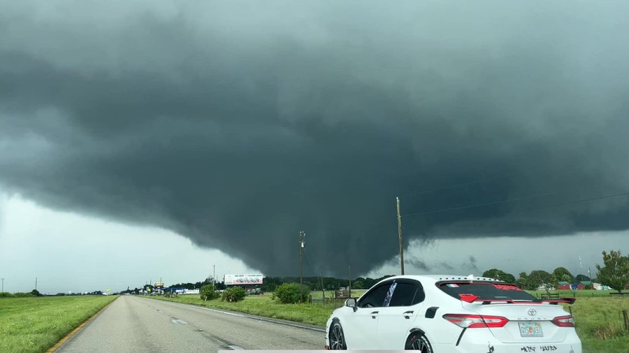
Several wedge tornadoes being reported in the vicinity of Lake Okeechobee. Lke this one
-
 1
1
-
-
After the Orioles' dreadful performance, another dank and dreary day would kinda fit my mood this morning.
-
14 minutes ago, clskinsfan said:
Hugo was a baby compared to this. Tiny little bitch
Hugo was 937 mb when it hit SC. Helene as of 5 pm was 951. It may surpass Hugo. But, still, comparable.
-
The comparisons to Hugo are pretty apt I think. Strengthening on the way in, booking along, and liable to hit a major metro area far inland hard.
EDIT: One thing I just thought of, Hugo didn't seem to have a big affect on the southern Appalachians? I mean, like Helene is gonna blast them with.
May Discobs 2025
in Mid Atlantic
Posted
Small hail in upper NW. Pretty gusty too.