

09-10 analogy
-
Posts
1,144 -
Joined
-
Last visited
Content Type
Profiles
Blogs
Forums
American Weather
Media Demo
Store
Gallery
Posts posted by 09-10 analogy
-
-
It's like the severe weather expy of Boxing Day. Not as traumatic, maybe, but ...

-
 1
1
-
-
The 2012 derecho -- I know, it's annoying that gets brought up every time there's a severe threat, but there's a reason here -- wasn't, IIRC, supposed to be the main event. That was supposed to be the next day. Well, this is the reverse. The main event will be tomorrow for immediate metros, not today as was thought.
That's sound meteorological reasoning for you there.
-
1
-
 1
1
-
-
Trees do fall around here during severe weather and people have been killed. I'd WAG more people have died from straight line winds around here than from tornadoes, for instance. So it's not totally unwarranted to warn people of powerful thunderstorms ... probably has as much to do with how many trees we have (well, in NW DC at least, I'm as parochial as ever) than with the strength of the winds.
Is today hype-worthy? Probably not, but we'll see. That question can only be answered in retrospect anyway.
Anyway, plenty of sun right now. What I don't want is hail. Last time I went to the local auto body shop, I asked an innocuous question, and the p***k running the joint snapped at me for no discernable reason.
-
Moderate rain a hour or so ago, now nothing, but distant rolling thunder when it's cloudy, which for some reason I love. Seems like the goods might be on my doorstep but I'm used to the LWX radar and it's down and I'm not rich like the rest of you folks to be able to afford the fancy stuff.
If it was a killer band of snow just off to my north and west with me getting nothing, I'd be tearing my hair out (of course I shave my head so that's kinda irrelevant) but with convection, I can still hear the thunder and like I said, distant thunder with cloudy, humid weather is a nice vibe for me.
-
Hard to get robust lapse rates and shear, and timing, all aligned together around here.
But we don't get day 4 outlooked by SPC too often around here, either (not that northern parts of the sub are).
EDIT: Not that it means anything, but this has been an aberrant June, what with all the tornadoes in the South (when their peak is usually well over by now) and then the tornadoes in Texas the other day. (I read somewhere that Texas hadn't had an (E)F4 after June 10th until this year, with Matador almost certainly being (E)F4 at least.)
-
1
-
-
25 minutes ago, MN Transplant said:
Brushed by that cell in McLean. 0.04”
Yeah looks like that one's wide left for me. Hearing the rolling thunder from it, though. Loud booms with CG close strikes are great, but sometimes just that low rumbling is soothing ... at least to me. And since it's a holiday, and cloudy and muggy out, there's not much activity -- vehicle or pedestrian -- on the streets, so it's quieter than a normal summer evening here. Relative silence a nice aural-point to the thunder.
-
Two rarities for this season today: humidity and the distant sound of thunder.
-
21 minutes ago, yoda said:
Confirmed TOR in SE VA right now
BULLETIN - EAS ACTIVATION REQUESTED
Tornado Warning
National Weather Service Wakefield VA
456 PM EDT Fri Jun 16 2023

The National Weather Service in Wakefield has issued a

* Tornado Warning for...
  The western City of Norfolk in southeastern Virginia...
  The northern City of Portsmouth in southeastern Virginia...
  Northeastern Isle of Wight County in southeastern Virginia...
  The northeastern City of Suffolk in southeastern Virginia...

* Until 530 PM EDT.

* At 455 PM EDT, a confirmed tornado was located over Crittenden, or
  near Carrolton, moving east at 25 mph.

  HAZARD...Damaging tornado and quarter size hail.

  SOURCE...Public confirmed tornado.

  IMPACT...Flying debris will be dangerous to those caught without
           shelter. Mobile homes will be damaged or destroyed.
           Damage to roofs, windows, and vehicles will occur.  Tree
           damage is likely.

* The tornado will be near...
  Crittenden around 500 PM EDT.
  Churchland around 515 PM EDT.
  Portsmouth around 520 PM EDT.
  Old Dominion University and Norfolk NAS around 525 PM EDT.
  Norfolk and Ghent around 530 PM EDT.

Other locations impacted by this tornadic thunderstorm include
Huntersville, Hobson and Carrollton.

PRECAUTIONARY/PREPAREDNESS ACTIONS...

To repeat, a tornado is on the ground. TAKE COVER NOW! Move to a
basement or an interior room on the lowest floor of a sturdy
building. Avoid windows. If you are outdoors, in a mobile home, or in
a vehicle, move to the closest substantial shelter and protect
yourself from flying debris.

Please report severe weather by calling 757-899-2415, posting to the
NWS Wakefield Facebook page, or using Twitter @NWSWAKEFIELDVA.

&&

LAT...LON 3683 7632 3685 7639 3687 7640 3687 7642
      3686 7643 3690 7657 3699 7656 3698 7647
      3695 7643 3697 7639 3696 7628 3688 7628
TIME...MOT...LOC 2055Z 285DEG 22KT 3694 7653

TORNADO...OBSERVED
MAX HAIL SIZE...1.00 IN
Not good, right into the urban area. And during rush hour and holiday weekend traffic.
-
28 minutes ago, Eskimo Joe said:
I'm actually happyO with that. It's a great way to understand the thinking behind SPC's outlook and watch decision making.
Oh I have no problem with it at all, I find them informative reading too. It just struck me as unusual. But maybe it happens more than I think.
-
There seems to be an awful lot of MDs out given there's no widespread severe outbreak going on.
-
3 minutes ago, 09-10 analogy said:
Maybe this detritus to our west will lay down some of those elusive “outflow boundaries” that could kick start whatever comes thru later.
That’s severe season equivalent of “backbuilding.”
Edit: I should note there seem to be some decent activity up by the Mason/Dixon ( or as my friend calls it, the Manson/Nixon) line.
-
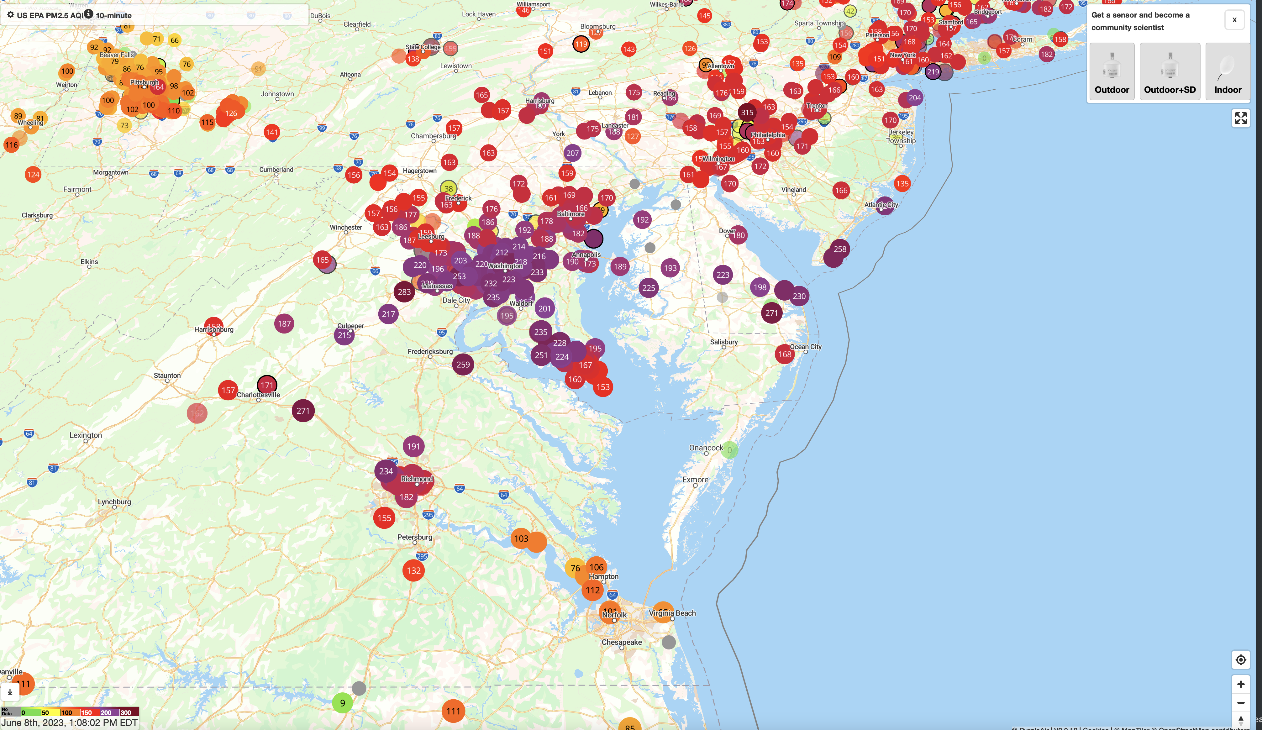
6 hours ago, high risk said:
Consistent with reports in this thread, low-level smoke concentrations are dropping in areas north and northwest of DC. Still lousy air but some modest improvement:
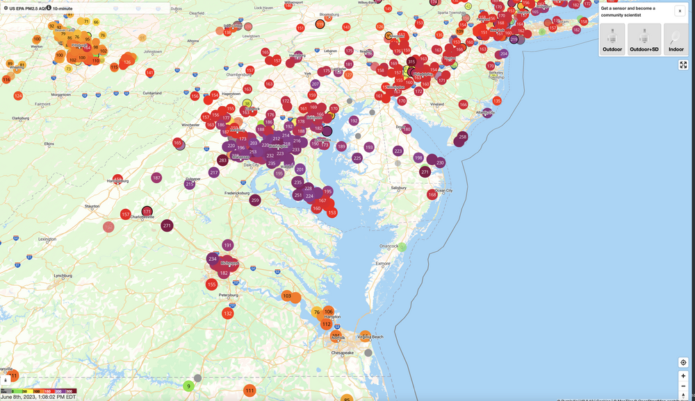
The HRRR smoke products have been consistently showing this scenario. Here is the latest run's forecast for low-level smoke later this afternoon.
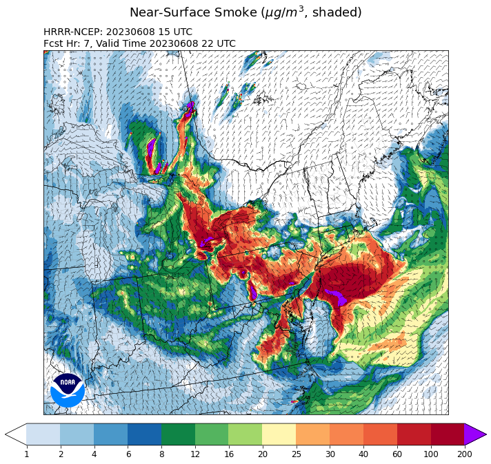
Tomorrow, unfortunately, looks worse again:
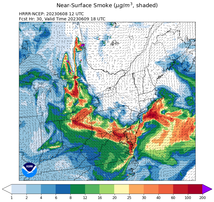
An MSS (mesoscale smoke system)? I mean, it's not convection, but it's horizontal dimension seems > 50 miles, and it sure is persistent.
-
51 minutes ago, NorthArlington101 said:
Feels like things have gotten worse again in the last 90 based on visibility out my window in Courthouse.
This has to be the current front runner for Weather Event of the Year (WEY) in these parts, right? Decent duration, high unusuality score, top story everywhere….
edit: maybe the darkness is more this than the smoke
I'd say so. Even if there was some competition (which I can't think of, 2023 has to be the most boring year in recent memory up to this point), this is historically noxious air. (Even the fleeting Xmas cold wave was 2022.) Shame that's it coincided with such (otherwise) conventionally beautiful weather.
This isn't exactly fun, but I'll probably remember it more than some 4-8" snowstorms (not that those occur anymore around here.) Kind of like the March 2018 long-term wind event: just very unique.
-
32 minutes ago, Stormfly said:
Have to wonder how this affects wildlife. Birds are still very chirpy here.
I was wondering about that too. Birds this morning were singing away as usual. Still, it's significantly better (at least in T-town) than it was earlier today.
-
1 minute ago, George BM said:
I wonder when the last time a Code Purple for air quality was issued for DC.
There's your next month's chat opener.
-
 1
1
-
-
"I love the smell of burning Canadian forests in the morning ... that burnt grilled food in a trash bag smell ... it smells of ... victory ... someday these forest fires will end, son."
-
2
-
3
-
-
Yeah, the smell doesn't really bring out the marshmallows over the old campfire vibe.
Maybe we need a new thread: "The Great Haze Event of June 2023."
-
2
-
-
Add haze to fog, nonconvective wind, and heat to things we do well around here.
Though I have to admit, the heat has been a welcome absence so far. I usually associate poor air quality with heat, so this little episode of Canadian Wildfire Visitation is somewhat dissociative, especially reading the 32 degree ob from West Va.
EDIT: Opened my window and within 15 minutes my throat started feeling scratchy. I really need to go up to Fort Reno and see if I can see the skyline of Tysons like is normally visible.
-
10 hours ago, George BM said:
Hurricane Idalia Advisory Number 32
11AM EDT Friday, August 25, 2023
Max Sustained Winds: 230mph, Gusts: 280mph
Moving: NNW(345*) at 29mph
Min Sea-Level Pressure: 832mb
Idalia has taken advantage of the 35-36C SSTs off the southeastern US w/ limited shear and a moist environment available and has become an unprecedently catastrophic category 5. Idalia will race inland over the Carolinas and northwards over the Mid-Atlantic region through the day ahead of an advancing through coming out of the west and will blast into the interior northeast and southeastern Canada by late this evening. An unfathomable storm surge of upwards of 50 feet is expected along the North Carolina coast from Wilmington to Morehead City with a catastrophic surge up the Chesapeake Bay all the way up through Long Island, NY. Hurricane Warnings extend north through the Carolinas, Mid-Atlantic, northeast and into southeastern Canada and the Great Lakes.
Rainfall will easily total 1 to 2 feet in these areas w/ localized amounts upwards of 3 feet in the Appalachians. Widespread hurricane-force winds will cause extreme wind damage through the warned area with extreme (115+mph winds) extending as far inland as places such as Toronto, Canada and Syracuse, NY.
Satellite Image: 10:50AM EDT August 25, 2023
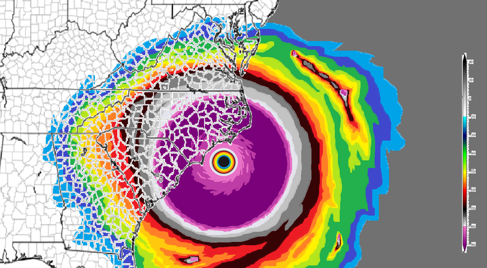
Them dastardly underwater volcanoes at it again.

Shouldn't be much of an impact locally. After all, there's no trees left and most of the construction in the DMV ought to be able to handle 140 mph straight-line winds.

Outer Banks are gone for good, but, hey, things happen.
-
4
-
-
Some pretty heavy rain at times. Distant thunder
-
On 5/17/2023 at 12:04 PM, WxWatcher007 said:
Increasing odds of the cat 5 up the bay scenario becoming a reality?
Mawar’s eastern sibling loves it some Chesapeake.
I see they’ve got Ophelia lined up as a name for the Atlantic. So because they’re running short of “I” names (I mean, rilly, “Idalia”?), they ought to go full Bard and put “Iago” into the rotation.
-
2
-
-
10 hours ago, MillvilleWx said:
Hey everyone! Just letting y'all know that my wife and I will be in the area sometime in August until potentially forever because I got the job at the Weather Prediction Center!!!
I AM COMING HOME!!!

Wow! Great going and welcome back to the DMV! Hope u can work some magic at WPC to improve our winters.
-
1
-
-
Just got back from picking up my kid from uni {as the Brits say) in central NYS. Very cool seeing the green blush of spring in the trees get lighter and lighter as we drove north.
-
1
-
-
On 4/30/2023 at 10:57 PM, George BM said:
Forecast Discussion
Tuesday, June 20, 2023 10:58AM EDT
Flash Flood Watch in effect for the greater Washington/Baltimore Metro area until 5am EDT Wednesday, June 21, 2023.
Tropical Storm Warning in effect for the greater Washington/Baltimore Metro area until further notice.
Discussion:
Heavy rains will continue to overspread the region as the center of Tropical storm Bret moves up the Chesapeake Bay. Interaction with a shortwave trough to the west over the Ohio Valley will help enhance lift and, therefore, the rainfall in the area extending roughly 50-100mi west of the center. This, of course, will put these enhanced tropical rainbands over The DC metro and the western half of the Baltimore metro. With Pwats of around 2.5”, high freezing levels (~15-16kft) and strong forcing from the trough to the west a large 50+ mile wide band of 2-3”+/hr rainfall rates w/ even higher rates in embedded bands. This will allow much of the area between I-81 and the Chesapeake Bay to receive upwards of 12-18”+ of rain w/ local amounts eclipsing 2' possible. This will lead to catastrophic flooding not only in flood prone areas but also flooding in many areas that don’t normally flood or have NEVER flooded before. The heaviest rainfall rates will occur over the region between midday and 8pm this evening.
Another factor from Bret will be strong NE, northerly, then NW winds. The highest winds will occur between 2pm this afternoon and 9pm this evening when winds could gust 40 to 60mph. This may lead to scattered to numerous power outages from fallen trees especially when considering how wet it’s already been since the end of April.
…
Bottom line is that this is the beginning of a very high impact event for the region. Impacts from this will be felt for many weeks or even months.
Forecaster Wannabe: George BM
I guess what trees were left over from your May blizzard were removed by Bret. It's gonna look like eastern Colorado around here!
-
3
-

2023 Mid-Atlantic Severe Wx Thread (General Discussion)
in Mid Atlantic
Posted
Bears repeating ...