griteater
-
Posts
9,581 -
Joined
Content Type
Profiles
Blogs
Forums
American Weather
Media Demo
Store
Gallery
Everything posted by griteater
-
Since when did it become normal behavior to be disappointed when a model doesn't show snow in Orangeburg?
-
and the 12z GFS is quite wintry in NC next Monday
-
12z CMC has some wintry precip in western NC next Sat night into Sunday, then has 2 additional weak systems that are close calls for wintry precip on the following Mon and Wed
-
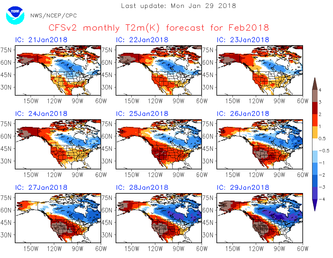
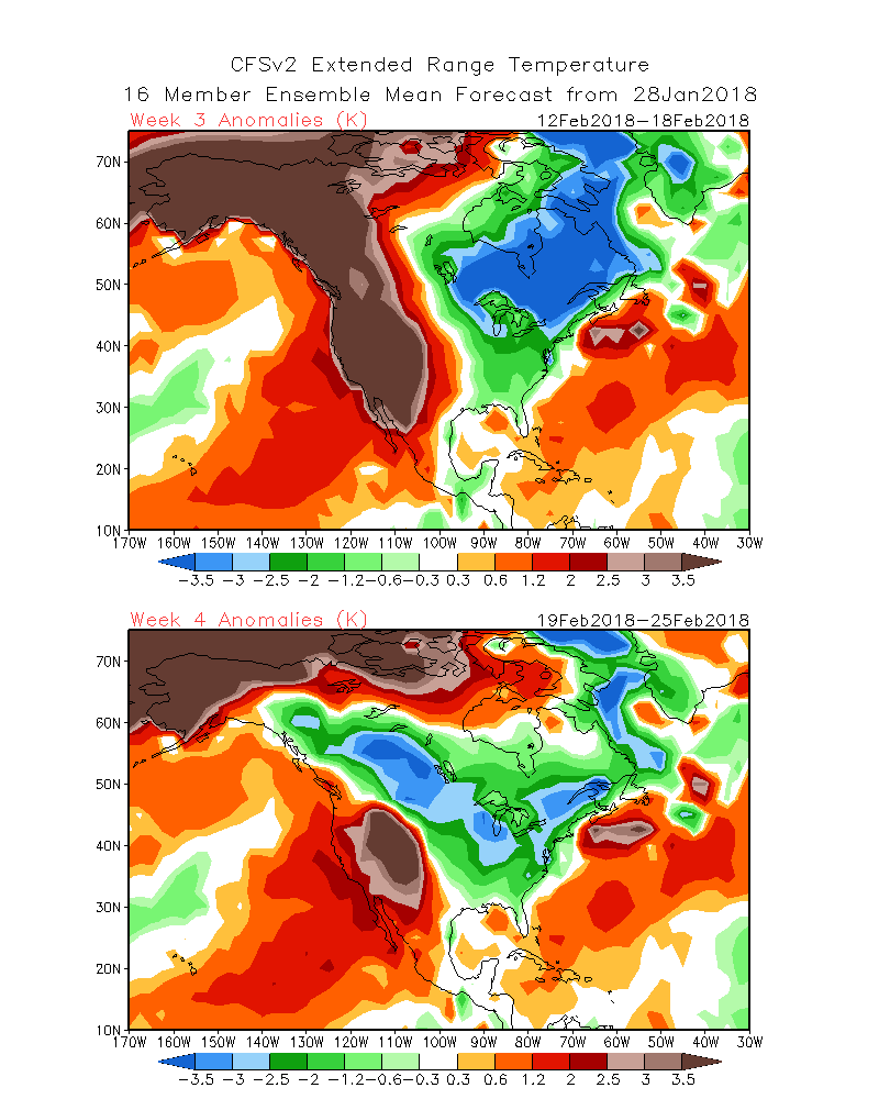
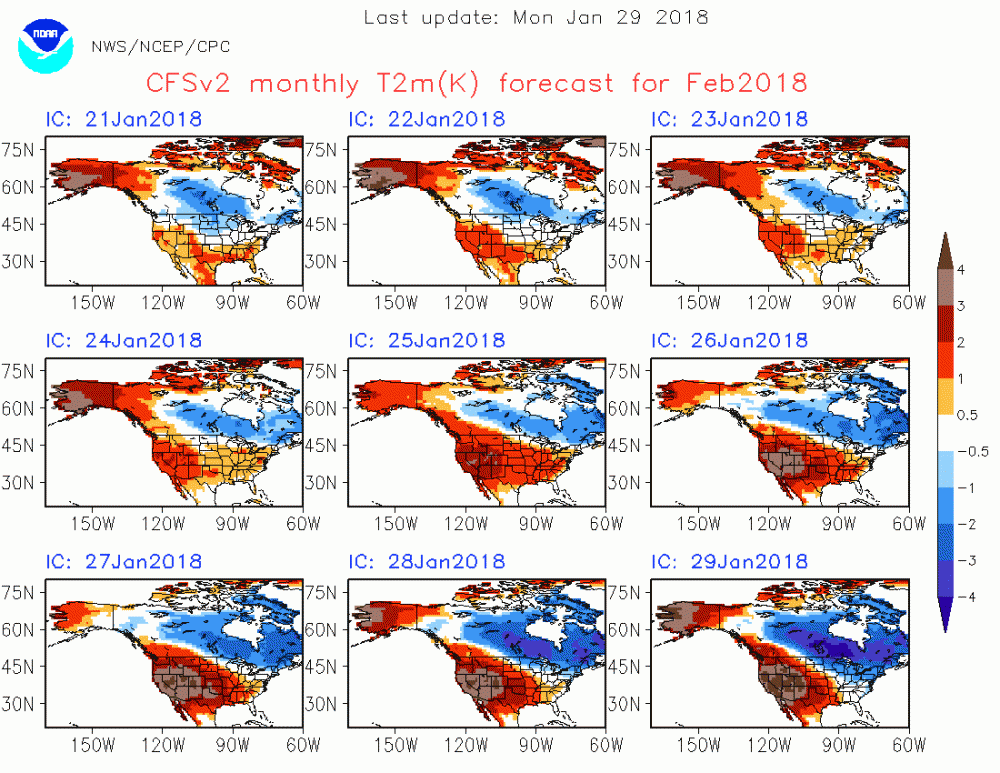
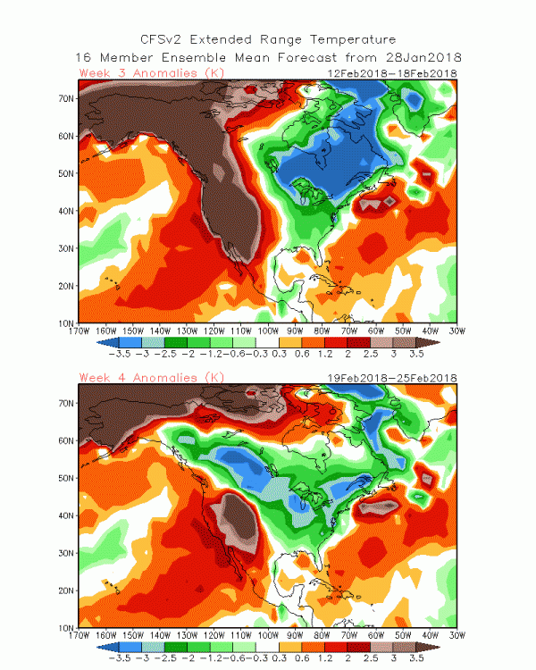
Looking at the latest on the much ballyhooed MJO, I noticed that the Euro, JMA, and CFS all move the MJO east into Phase 8 quicker than the GFS. When viewing the -VP anomaly movement associated with the MJO over the past few weeks and projecting that forward (along with forecasts), it looks to me that we are on track for the MJO to begin being in a favorable location in mid-Feb, with the -VP anomalies moving into the Eastern Pacific during that timeframe. Here are the February monthly and Week 3 & 4 temperature forecasts from the latest CFS. The monthly has continued to trend cooler in the east and warmer in the west.
-
That's fine, but no one wants to hear mumbling and grumbling and whining in this thread. There are other threads specifically for that. Plus we hear enough of that at home.
-
GFS says why wait til mid Feb for cold and active weather
-
I hear ya, it IS speculation, but I just think there are times that we can have some success with forecasting the large scale pattern using educated guesses
-
Hmm, surprised you would say that. Should be able to take ENSO + MJO and some model weeklies (EURO/CFS/JMA) to pump out large scale pattern ideas for weeks 3-4
-
It's rare to see Mike Ventrice give a forecast like that on a public forum. His thoughts match up with what we've been saying on here, increased chances for cold intrusions from mid Feb into early March
-
Y'all crazy, especially you Mack! I'm pretty optimistic for mid-Feb on into March. The -EPO that develops in early Feb should deposit the bulk of the Northern Hemisphere cold into North America. As the MJO progresses east into mid-Feb, we should be in better position to receive more of that cold air with better western ridge positioning. The one fly in the ointment to me could be if the stratospheric PV strengthens and gets wound up tight where the cold air wants to stay bottled up to our north (in Canada).
-
New Euro Weeklies keep the -EPO pattern with SE ridging and core of the cold to our NW (over the north central states and Canada) thru week 3 (Feb 8-15), then the Aleutian low and western ridge move east so it's more of a +PNA look for mid Feb into early March, however, it's +NAO and the core of the cold stays over the NE and E Canada verbatim on the model in mid-Feb, before cold anomalies work in toward the last 1/3 of Feb and early Mar.
-
I predicted we would have a few quality blocking episodes this winter (AO/NAO combo)....lol
-
^ Euro weeklies come out tonight based off that 00z run above, so we'll see what it thinks rolling forward into mid and late Feb
-
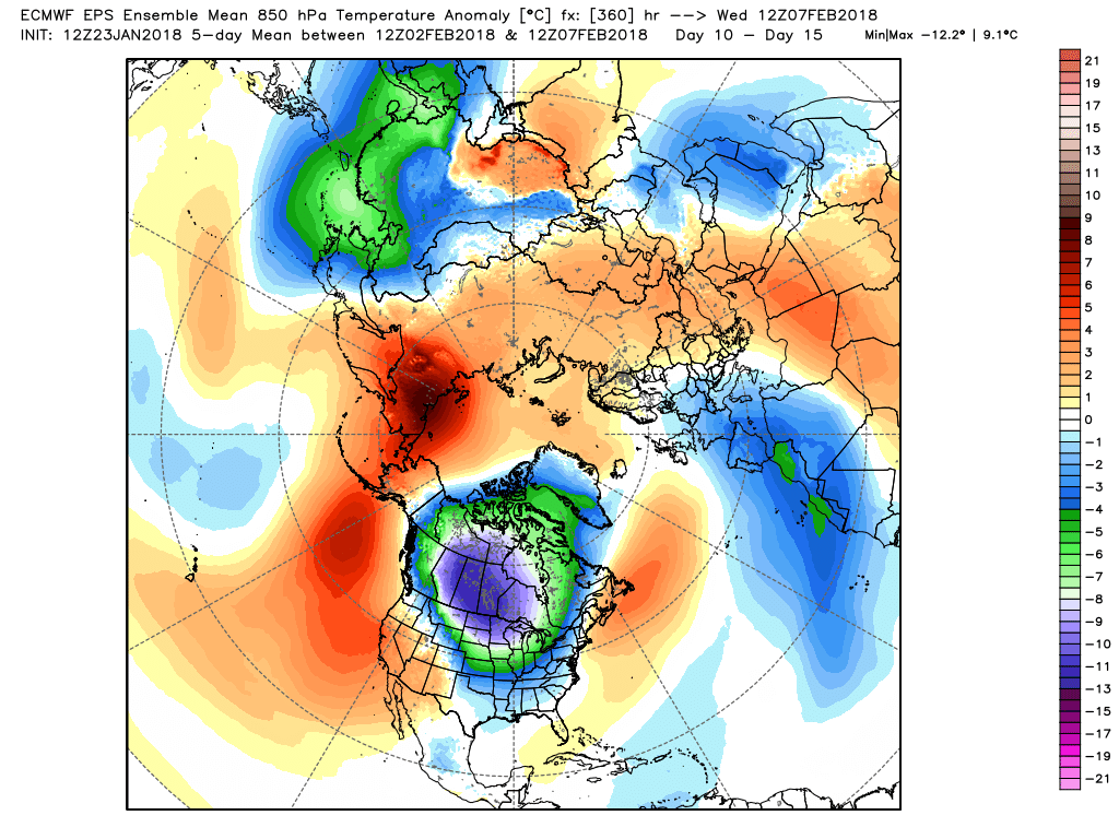
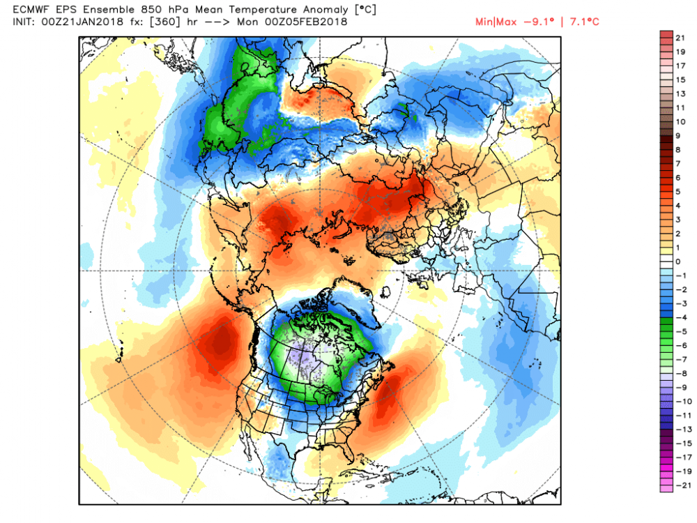
Thanks, below is the EPS for days 10-15. Control run is actually quite warm in the SE during that timeframe (snow in the Rockies with SE ridge).
-
My latest thoughts are that early Feb will favor a more traditional -EPO pattern where the core of the cold is to our NW, transitioning to a colder mean pattern for us in the mid Feb timeframe. Here's the GEFS on Feb 5. We do better cold-wise when the mean western ridge is in E Alaska / W Canada as opposed to straight thru Alaska like this image. We currently have the most coherent MJO event of the winter ongoing, but it's going to take some time for it to propagate east out of the Maritime Continent / Western Pacific into the Eastern Pacific. The bad news is that a stronger MJO event means slower propagation, with the good news (for cold lovers) being that a slower propagation may keep the MJO in the cold phases longer. The weekly NOAA MJO Updates have good info related to the MJO (http://www.cpc.ncep.noaa.gov/products/precip/CWlink/MJO/mjoupdate.pdf). Here are a few snippets from the latest version... "The MJO remains active, with the enhanced phase over the Maritime Continent and the suppressed phase over the Pacific. A robust Wave-1 asymmetry remains very apparent in the upper-level circulation pattern, reflecting an organized MJO event. Dynamical and statistical models strongly support continued MJO activity, with the enhanced phase propagating from the Maritime Continent to the West Pacific over the next two weeks. Recent MJO activity teleconnects well with the current extratropical pattern over the CONUS. If a robust West Pacific MJO event occurs, the extratropical response may favor a transition to a colder pattern for the central and eastern U.S. during mid-February" We shall see...these are just some long range thoughts that are inherently less reliable than short range.
-
Kind of amazing though that the GFS wipes out a lot of the January cold anomalies by the end of the month. 1st image is the 7 day GFS forecast. 2nd image is January to date plus the 7 day GFS forecast (to Jan 30).
-
I'd say it's unlikely statistically...but it's just long range projection stuff at this time
-
?? Do you mean the fact that the cold is too far to the northwest? Agree with Mack, those are some impressive cold numbers showing up for a long range ensemble mean, and it's trending colder at the moment at the end of the run. I wouldn't be surprised to see the cold correct more to the south and east in time on the ensembles, especially given the eastward progression of the MJO. Sometimes -EPO cold can get hung up too far to our northwest, but the MJO should help to move the mean western ridge eastward in time through February, with some retrogression back west toward the end of Feb into early March...we'll see. Also, if those blues were right on top of us, we'd have some playing the suppression card (I don't even have the suppression card in my card deck, ever...bring on the cold, and let's go from there) The Northern Hemisphere 5 day view shows that look again where the coldest air is in North America...that's a good sign for subsequent cold plunges

-
Euro has a nice cross polar flow look to it at the end of the run
-
Do we trust the weeklies? They haven't been that great this winter. They've been fine from what I've seen. They were too quick to warm things up in Jan, but we're in it now
-
Euro Weeklies come in pretty much as expected. Has western ridge / eastern trough pattern beginning in week 3 (Feb 5-12) and continues through early March. +NAO. Looks northern stream dominant like we've had most of the winter. Precip is below normal weeks 3 to 4...near normal thereafter thru week 6
-
The MJO has received a lot of attention lately with respect to the upcoming pattern, and rightfully so. The active MJO phase is currently located over the eastern Maritime Continent and Western Pacific (seen here via -VP anomalies in blue & purple; -VP measures upper level divergence associated with tropical convection). Source for this loop: http://www.atmos.albany.edu/student/ventrice/real_time/maps/mjo/global_analyses.html The strongest tropical forcing (-VP forcing) of this winter was recorded in that region just last week: https://twitter.com/MJVentrice/status/955430819581059072 MJO > Mid-Latitude Circulation theory suggests that the potential for western ridging and eastern troughing will go up once these -VP anomalies move east into the Eastern Pacific and continue east thru Africa. See Mike Ventrice's AMS Conf Presentation for more info: https://ams.confex.com/ams/95Annual/videogateway.cgi/id/29036?recordingid=29036 The CFS forecast moves the -VP anomalies into the eastern Pacific in the Feb 5-11 timeframe. From there, the MJO would support, say, a 3-4 week window where periods of western ridge / eastern trough are likely. Source: https://ncics.org/portfolio/monitor/mjo/ (the term "CHI" here = VP Anomalies; green is -VP) Today's EPS Mean has a western ridge / eastern trough at day 15 (Feb 6) The pattern of northern stream dominance, typical of La Ninas, and especially 2nd year La Ninas, could continue as the subtropical jet has been notably absent thus far this winter. Note the blue shading along 20N - 30N just NE of Hawaii and extending east into the Gulf of Mexico, indicating zonal westerly winds at 250mb that have been weaker than normal so far this winter.
-
^ That would plop the coldest anomalies over the Northern Hemisphere in North America for the 3rd time this winter. Let's get greedy
-
Temperature Departures for Dec and Jan to date
-
Winter to date...