The Waterboy
-
Posts
1,008 -
Joined
-
Last visited
Content Type
Profiles
Blogs
Forums
American Weather
Media Demo
Store
Gallery
Everything posted by The Waterboy
-
MO/KS/AR/OK 2020-2021 "Winter" Discussion
The Waterboy replied to JoMo's topic in Central/Western States
Little Rock 3am discussion mentions 20:1 ratios here. Observed snow:liquid ratios by midnight have ranged from 10:1 to nearly 20:1 across the central into NWRN AR...with a bit lower ratios further south due to the added sleet. -
MO/KS/AR/OK 2020-2021 "Winter" Discussion
The Waterboy replied to JoMo's topic in Central/Western States
5” measured about an hour ago. Maybe this last burst will push us to 6. We’ll see. -
MO/KS/AR/OK 2020-2021 "Winter" Discussion
The Waterboy replied to JoMo's topic in Central/Western States
Looks like we’re about to get a heavier band for the next hour or so. -
MO/KS/AR/OK 2020-2021 "Winter" Discussion
The Waterboy replied to JoMo's topic in Central/Western States
Measure 5” In multiple spots of the year. -
MO/KS/AR/OK 2020-2021 "Winter" Discussion
The Waterboy replied to JoMo's topic in Central/Western States
Awesome storm overall! Even if it didn’t drop huge amounts (8-12+) it was impressive for a few reasons: 1. Snow falling with it absolutely stupid cold. So much for the old saying, “It’s too cold to snow”. 2. Three different waves hit most of us. 3. As far as I can remember I’ve never been in a WS Warning while also having a WS Watch for another storm right behind it. This is VERY rare. The only “negatives” I can think of are we didn’t get a foot and no blizzard warning. That 8 year drought will continue, but who cares. Onto the next storm. As JoMo (or someone) mentioned yesterday the NAM and RAP seemed to handle this best. The HRRR not so much. We’ll see what round 2 (or is it round 4?) says. -
MO/KS/AR/OK 2020-2021 "Winter" Discussion
The Waterboy replied to JoMo's topic in Central/Western States
Better late than never! Let’s get this going!!! -
MO/KS/AR/OK 2020-2021 "Winter" Discussion
The Waterboy replied to JoMo's topic in Central/Western States
I know it’s jumping ahead but the 21z RAP has storm 2 further north. Looks good for most of us. Plenty of time to worry about that later but interesting to watch since the RAP has performed well so far. -
MO/KS/AR/OK 2020-2021 "Winter" Discussion
The Waterboy replied to JoMo's topic in Central/Western States
In not loving the current look of the radar as it moves our way. As JoMo said, it’s narrowing and potentially weakening some. It’s going to be hard to see 4-6” more unless it wraps up and we see more on the very backside as well. -
MO/KS/AR/OK 2020-2021 "Winter" Discussion
The Waterboy replied to JoMo's topic in Central/Western States
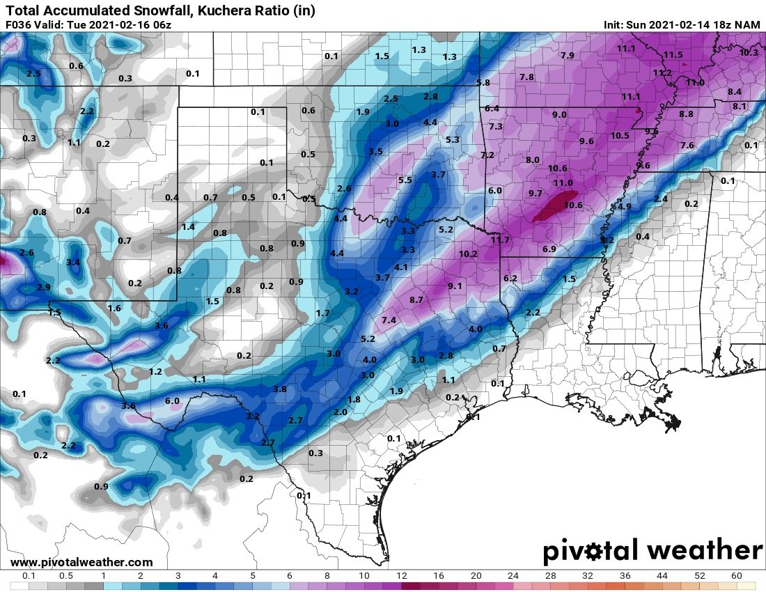
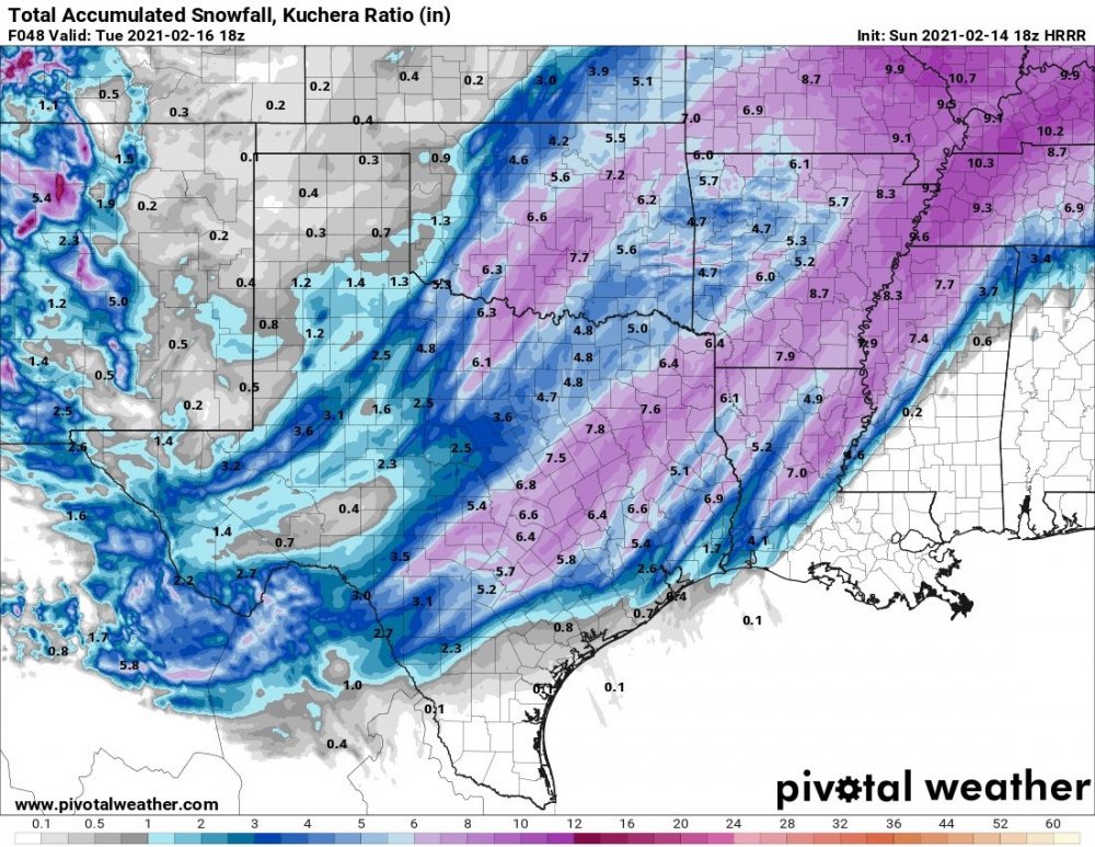
Using the Kuchera maps the 18z RAP, HRRR, and NAM all continue to show 3-8” additional through tomorrow.
-
MO/KS/AR/OK 2020-2021 "Winter" Discussion
The Waterboy replied to JoMo's topic in Central/Western States
Anyone have any live updates from the OKC area? -
MO/KS/AR/OK 2020-2021 "Winter" Discussion
The Waterboy replied to JoMo's topic in Central/Western States
^ I suspect we’re all too focused waiting anxiously on round 2 today. But good to see those maps. Looks like storm 2 continues to track a bit more SE each run. -
MO/KS/AR/OK 2020-2021 "Winter" Discussion
The Waterboy replied to JoMo's topic in Central/Western States
Last few HRRR runs hinting at wrapping the storm. Still snowing at 6 am tomorrow. -
MO/KS/AR/OK 2020-2021 "Winter" Discussion
The Waterboy replied to JoMo's topic in Central/Western States
I really wasn’t expecting much out of this first wave. The HRRR runs last night had these bands further west. So I’m considering this first part some bonus snow. Around an inch here so far but hard to tell for sure. -
MO/KS/AR/OK 2020-2021 "Winter" Discussion
The Waterboy replied to JoMo's topic in Central/Western States
Does the 12z GFS try to wrap it as well? Hard for me to tell. -
MO/KS/AR/OK 2020-2021 "Winter" Discussion
The Waterboy replied to JoMo's topic in Central/Western States
This is a perfect day!!!! NWS Tulsa increased amounts for us NWA folks just a bit. 5-9” for Bentonville in the written forecast details. -
MO/KS/AR/OK 2020-2021 "Winter" Discussion
The Waterboy replied to JoMo's topic in Central/Western States
That update is from 4:12 this afternoon. All they updated at 10:59 was the aviation. -
MO/KS/AR/OK 2020-2021 "Winter" Discussion
The Waterboy replied to JoMo's topic in Central/Western States
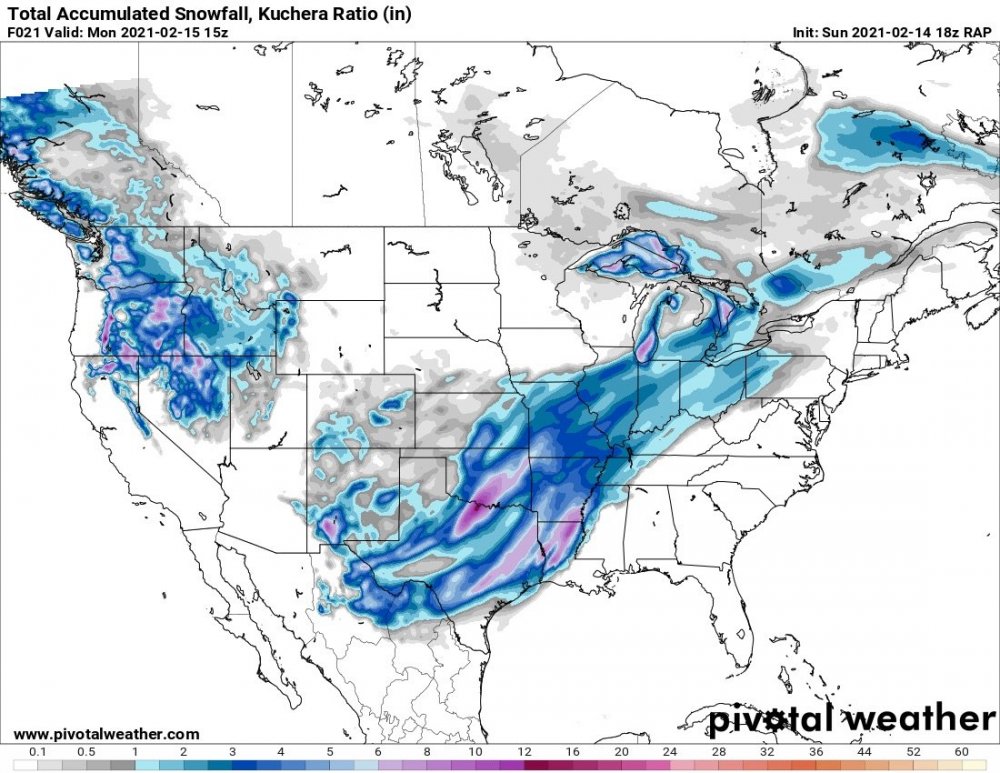
03z RAP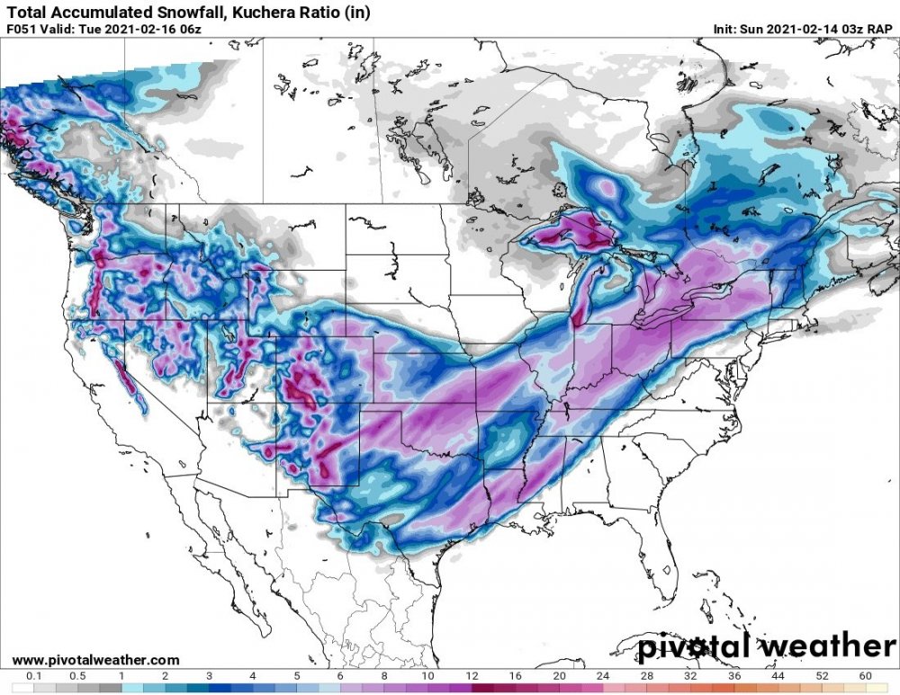
-
MO/KS/AR/OK 2020-2021 "Winter" Discussion
The Waterboy replied to JoMo's topic in Central/Western States
These radar returns in SW OK and Tulsa are very intriguing. That is at least 4-5 hours ahead of what the HRRR is showing. -
MO/KS/AR/OK 2020-2021 "Winter" Discussion
The Waterboy replied to JoMo's topic in Central/Western States
^ That’s a good thing, correct? It also seems to be a tick SE again. -
MO/KS/AR/OK 2020-2021 "Winter" Discussion
The Waterboy replied to JoMo's topic in Central/Western States
Thanks! Does the 18z keep the 2nd storm way south or did it come north closer to the GFS? -
MO/KS/AR/OK 2020-2021 "Winter" Discussion
The Waterboy replied to JoMo's topic in Central/Western States
Their comments about the heaviest amounts in SW OK don’t match the 18z GFS at all. It’s actually the exact opposite. Lowest amounts were in that area. -
MO/KS/AR/OK 2020-2021 "Winter" Discussion
The Waterboy replied to JoMo's topic in Central/Western States
Interesting that the GFS Kuchera ratios continue to be in the 15-18:1 range for storm 2. -
MO/KS/AR/OK 2020-2021 "Winter" Discussion
The Waterboy replied to JoMo's topic in Central/Western States
I think we’re going to be good. 4+ inches looks pretty solid. Especially if one of the bands shifts SE just a few miles. The RAP has it just trying to get into Benton Co. -
MO/KS/AR/OK 2020-2021 "Winter" Discussion
The Waterboy replied to JoMo's topic in Central/Western States
V16 continues to drop heavier amounts compared to the main run. -
MO/KS/AR/OK 2020-2021 "Winter" Discussion
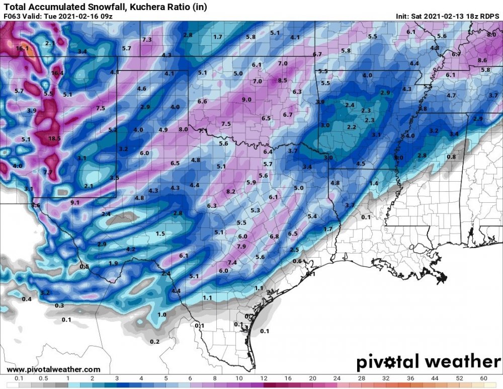
The Waterboy replied to JoMo's topic in Central/Western States
18z RDPS stayed pretty steady to 12z. Continues to slide the heavier bands just a tick SE especially if you compare the 06, 12, and 18z. 18z below...