

The Waterboy
-
Posts
1,008 -
Joined
-
Last visited
Content Type
Profiles
Blogs
Forums
American Weather
Media Demo
Store
Gallery
Everything posted by The Waterboy
-
MO/KS/AR/OK 2025-2026 Winter Discussion
The Waterboy replied to stormdragonwx's topic in Central/Western States
You and I switched over to snow around 8:30 and it’s been steady since then. That doesn’t really match up with saying primarily sleet south of I-44. -
MO/KS/AR/OK 2025-2026 Winter Discussion
The Waterboy replied to stormdragonwx's topic in Central/Western States
Bentonville/most of Benton County is under a heavier band on the radar right now, yet it’s barely spitting flurries. That makes zero sense whatsoever. Even when we get a decent band it’s a big nada. Edit: That’s because it’s sleet pellets. Ugh… -
MO/KS/AR/OK 2025-2026 Winter Discussion
The Waterboy replied to stormdragonwx's topic in Central/Western States
That makes sense. I’m starting to get more nervous and frustrated. Unfortunately we are fully at the mercy of Mother Nature. And often times she’s not very good to us around here. -
MO/KS/AR/OK 2025-2026 Winter Discussion
The Waterboy replied to stormdragonwx's topic in Central/Western States
The 18 and 19z HRRR fill in nicely around 03z (10 pm). What am I missing on the posts about a lot of dry air?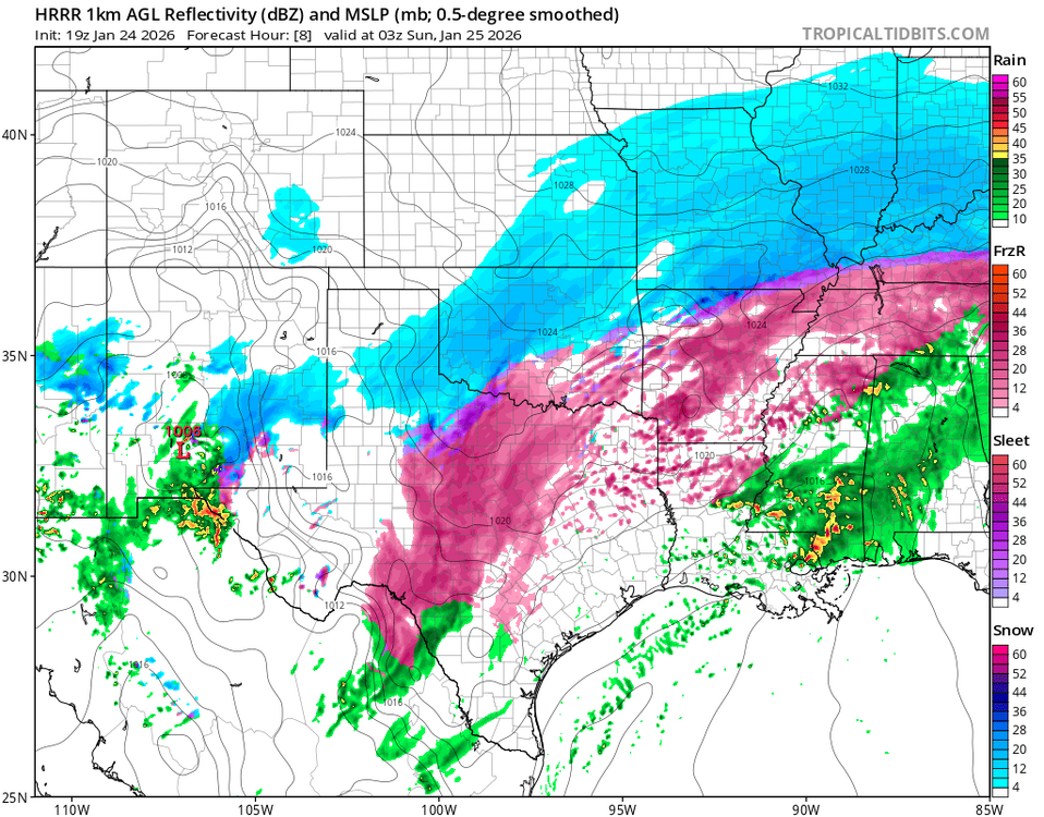
-
MO/KS/AR/OK 2025-2026 Winter Discussion
The Waterboy replied to stormdragonwx's topic in Central/Western States
Light snow has been consistent in Bentonville yet the radar shows nothing. Not sure if that’s a sign of the atmosphere squeezing out any moisture because it’s so cold or if lift is increasing quickly. -
MO/KS/AR/OK 2025-2026 Winter Discussion
The Waterboy replied to stormdragonwx's topic in Central/Western States
Mesoscale Discussion 0044 NWS Storm Prediction Center Norman OK 1034 AM CST Sat Jan 24 2026 Areas affected...Portions of West Texas into central Oklahoma Concerning...Winter mixed precipitation Valid 241634Z - 242030Z SUMMARY...An expanding area of mostly sleet will continue northeast through the afternoon. DISCUSSION...An area of showery precipitation continues to expand from West Texas into southwest Oklahoma this morning. The precipitation coverage is already more expansive than shown by any 12Z guidance and it continues to expand. -
MO/KS/AR/OK 2025-2026 Winter Discussion
The Waterboy replied to stormdragonwx's topic in Central/Western States
Let’s just all agree the HRRR sucks until it shows the solution we like. -
MO/KS/AR/OK 2025-2026 Winter Discussion
The Waterboy replied to stormdragonwx's topic in Central/Western States
Not sure what to make of it, if anything, but the 12z Euro and 18z Ukie don’t have the 6-8 hour dry break between the two systems. Also, the 21z RAP has wave 1 heavier amounts in S. KS and the very heavy amounts in West Central AR/Eastern OK. 5-6” from Bentonville to Joplin with much higher amounts from Fayetteville south. -
MO/KS/AR/OK 2025-2026 Winter Discussion
The Waterboy replied to stormdragonwx's topic in Central/Western States
18z Ukie stayed pretty steady. Pivotal Weather snow map is only at 10:1 ratio with 12+” throughout a large area of OK/AR. It would be very impressive if we had the Kuchera. -
MO/KS/AR/OK 2025-2026 Winter Discussion
The Waterboy replied to stormdragonwx's topic in Central/Western States
Even the 10:1 ratio map looks awesome! -
MO/KS/AR/OK 2025-2026 Winter Discussion
The Waterboy replied to stormdragonwx's topic in Central/Western States
If the NAM is right… Sorry, couldn’t resist. At least the NAM is the only model showing that much of a warm nose. I think most of us here just need it to stay south of 412. -
MO/KS/AR/OK 2025-2026 Winter Discussion
The Waterboy replied to stormdragonwx's topic in Central/Western States
I was just thinking the same thing. The NAM has spit out some stupid stuff throughout the years but this is a whole new level. A foot in many places seems quite feasible. -
MO/KS/AR/OK 2025-2026 Winter Discussion
The Waterboy replied to stormdragonwx's topic in Central/Western States
GFS just said Hold my beer… -
MO/KS/AR/OK 2025-2026 Winter Discussion
The Waterboy replied to stormdragonwx's topic in Central/Western States
Had the NAM gone out 6-12 more hours most of us would have ended with 15-18”. -
MO/KS/AR/OK 2025-2026 Winter Discussion
The Waterboy replied to stormdragonwx's topic in Central/Western States
Does anyone have the 18z Euro map? -
MO/KS/AR/OK 2025-2026 Winter Discussion
The Waterboy replied to stormdragonwx's topic in Central/Western States
Hot pink is my favorite color the rest of this week! Those maps are almost unbelievable. -
MO/KS/AR/OK 2025-2026 Winter Discussion
The Waterboy replied to stormdragonwx's topic in Central/Western States
We’re starting to cut it real close from OKC to Tulsa to Bentonville. That run gives me 11” but 50 miles south is 6” of sleet. Can’t recall ever seeing that much sleet modeled. JoMo is in the bullseye now and looking good. Now we just need it to settle in and not continue the NW jog. -
MO/KS/AR/OK 2025-2026 Winter Discussion
The Waterboy replied to stormdragonwx's topic in Central/Western States
GFS and GFSAI both trended upward in total QPF from 12z to 18z. Here’s the change on the GFS for Tulsa, Bentonville, and Joplin. Joplin - .05 to .17 Bentonville - .08 to .35 Tulsa - .18 to .55 GFSAI were even higher than the Ops run. With high snow ratios that small amount of increase in QPF has a sizable change in snow amounts. Definitely looks like the GFS caved towards the other models. 18z ICON was a tad further SE than 12z. We were in the sweet spot at 12z. And I personally thought the 18z NAM looked solid at 84. -
MO/KS/AR/OK 2025-2026 Winter Discussion
The Waterboy replied to stormdragonwx's topic in Central/Western States
12 Euro ticked NW with the heavier snow. Solid run. -
MO/KS/AR/OK 2024-2025 Winter Discussion
The Waterboy replied to JoMo's topic in Central/Western States
Wondering how you all feel about these: 1. I’ll take a wet snow over a dry, blowing snow pretty much every time. 2. I much prefer models showing a few inches and the storm over performing vs this nonsense of 12” turning into way less. -
MO/KS/AR/OK 2024-2025 Winter Discussion
The Waterboy replied to JoMo's topic in Central/Western States
You jinxed it! And we’re all blaming you!!! -
MO/KS/AR/OK 2024-2025 Winter Discussion
The Waterboy replied to JoMo's topic in Central/Western States
Finally started coming down heavier in Bentonville. Road/driveway coated in 30 mins or less. We’re going to need these heavy bands to continue for a few hours straight in order to get 6+. -
MO/KS/AR/OK 2024-2025 Winter Discussion
The Waterboy replied to JoMo's topic in Central/Western States
All snow here in NWA. Decent sized flakes. Roads are primarily wet even at 23°. Happy to see we escaped the sleet/fz rain. Hopefully everybody transitions quickly. -
MO/KS/AR/OK 2024-2025 Winter Discussion
The Waterboy replied to JoMo's topic in Central/Western States
Fair enough. That makes sense. Now it’s time to have fun and see what happens! -
MO/KS/AR/OK 2024-2025 Winter Discussion
The Waterboy replied to JoMo's topic in Central/Western States
The mood here soured quickly…. what happened??? Edit: 03z RAP only shows 13” for me versus the 18” on the 21z. Let’s not throw out the baby with the bath water.


