The Waterboy
-
Posts
1,008 -
Joined
-
Last visited
Content Type
Profiles
Blogs
Forums
American Weather
Media Demo
Store
Gallery
Everything posted by The Waterboy
-
MO/KS/AR/OK 2023-2024 Winter Discussion
The Waterboy replied to JoMo's topic in Central/Western States
NAM going to come in further south. Ugh. -
MO/KS/AR/OK 2023-2024 Winter Discussion
The Waterboy replied to JoMo's topic in Central/Western States
18z HRRR looks solid. Decent uptick around Tulsa compared to 12z run. -
MO/KS/AR/OK 2023-2024 Winter Discussion
The Waterboy replied to JoMo's topic in Central/Western States
Thanks for the info! What do the Ensembles show for the Friday storm? -
MO/KS/AR/OK 2023-2024 Winter Discussion
The Waterboy replied to JoMo's topic in Central/Western States
For what it’s worth (which might not be much) the RGEM, RAP, and HRRR have 1-2” for NWAR and Missouri. Lesser amounts further west. Cue the “So you’re saying there’s a chance” GIF. -
MO/KS/AR/OK 2023-2024 Winter Discussion
The Waterboy replied to JoMo's topic in Central/Western States
Over the last few runs most of the models continue to speed up the cold front on Friday. Typing this on my phone so the formatting could be wonky when I post this. HR 72 temp for Bentonville ICON - 48 GFS - 25 CMC - 44 NAM - 42 RGEM - 45 Euro - 47 (06 run) HR 78 temp ICON - 24 GFS - 20 CMC - 21 NAM - 29 RGEM - 18 Euro - 44 (06 run) By hr 84 all models (except NAM) are in the mid teens to lower 20’s. RECAP: GFS is much faster with the front. Euro much slower. NAM is pretty much non-existent with the front at all. Temps on the ICON after hour 84 are stupid cold. 5 straight days below zero. There should be a quick changeover to snow. We need to continue to see the trend of a faster solution. One additional note regarding faster push from GFS: Tulsa’s temp at 06z Friday: 18z run yesterday - 50 00z run - 49 06z run - 31 12z run - 27 -
MO/KS/AR/OK 2023-2024 Winter Discussion
The Waterboy replied to JoMo's topic in Central/Western States
It has been an interesting trend for sure. You guys in Wichita might get 4+ out of it. Hoping we can see that same trend as it gets into NWAR/SWMO tomorrow morning. -
MO/KS/AR/OK 2023-2024 Winter Discussion
The Waterboy replied to JoMo's topic in Central/Western States
18z NAM trended towards HRRR for tomorrow. Still nothing to get too excited about but maybe we can eke out an inch or two. -
MO/KS/AR/OK 2023-2024 Winter Discussion
The Waterboy replied to JoMo's topic in Central/Western States
Well that’s new. Not surprising though. Hopefully it’s a blip. -
MO/KS/AR/OK 2023-2024 Winter Discussion
The Waterboy replied to JoMo's topic in Central/Western States
Significant differences at hour 84 with the NAM versus GFS/GEM. NAM seems to be the outlier as of now which is in our favor. I’m pretty sure the NAM typically sucks that far out. Hoping the Euro is in our favor. -
MO/KS/AR/OK 2023-2024 Winter Discussion
The Waterboy replied to JoMo's topic in Central/Western States
Probably an inch or so here in Bentonville. In the words of Billy Madison, not too shabby. Let’s hope this is the appetizer to next week’s main course. -
MO/KS/AR/OK 2023-2024 Winter Discussion
The Waterboy replied to JoMo's topic in Central/Western States
Interesting info in the Springfield NWS write-up overnight: Attention then turns to the next large storm system that will come through Monday through Tuesday. It is quite impressive how much agreement there has been between the GFS/ECMWF/Canadian deterministic models (and even ensembles to some degree) for such a dynamic system. A very potent deep trough will scoop through the central CONUS, forcing a deep surface low that will create moderate to heavy precipitation for much of the central and eastern US. For starters, the NAEFS/ENS ESATs prog this trough/low pair as the lowest pressure they have modeled in the last 30 years for our area at this time of year. With such a storm system, we will likely see at least minor impacts (currently 30-50% chance from the Probabilistic Winter Storm Severity Index). There is still uncertainty in exact track which could determine whether our impacts are mainly rain-based or snow-based. Nevertheless, the synoptic setup is continuing to match well with our Heavy Snow Climatology: ENS and GEFS member surface low locations are clustered within northern AR, the 850 mb low moves through south-central MO, and the 500 mb low is closing and extends into OK; all which match with heavy snow climatology for our area. The only difference is that we would like to see a more negatively tilted trough versus the positive tilt that is shown in many ENS/GEPS members, which may struggle to force colder air into the region for snow. At this point in time, the most likely scenario looks to be moderate rain initially within the warm-air advection regime ahead of the low, then potentially some moderate snow on the backside of the low for at least some of our CWA (more likely toward the north). Finer details will be ironed out in subsequent forecasts -
MO/KS/AR/OK 2023-2024 Winter Discussion
The Waterboy replied to JoMo's topic in Central/Western States
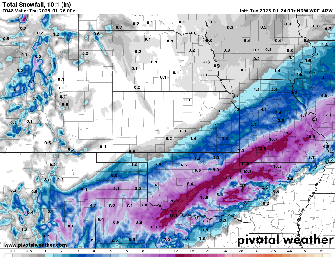
18z HRRR was pretty juicy. 1-3” inches through OK into Western/NW AR. -
MO/KS/AR/OK 2022-2023 Winter Discussion
The Waterboy replied to JoMo's topic in Central/Western States
Bentonville/Bella Vista getting hammered right now with heavy sleet. -
MO/KS/AR/OK 2022-2023 Winter Discussion
The Waterboy replied to JoMo's topic in Central/Western States
Measured 5” in Bentonville. Also have one minor tree limb that snapped. -
MO/KS/AR/OK 2022-2023 Winter Discussion
The Waterboy replied to JoMo's topic in Central/Western States
How is The Great Tulsa Donut Hole of 2023 even possible? That’s just stupid and really sucks. Especially for all the hype this storm had over the past week. -
MO/KS/AR/OK 2022-2023 Winter Discussion
The Waterboy replied to JoMo's topic in Central/Western States
It seems like every hourly run of the RAP and HRRR continue to shift to the SE. Pretty soon Little Rock’s going to be in the sweet spot. LOL. -
MO/KS/AR/OK 2022-2023 Winter Discussion
The Waterboy replied to JoMo's topic in Central/Western States
Meaning the current actual temp is 2-3 colder than what the HRRR shows? -
MO/KS/AR/OK 2022-2023 Winter Discussion
The Waterboy replied to JoMo's topic in Central/Western States
Then I’ll take this one please!!!
-
MO/KS/AR/OK 2022-2023 Winter Discussion
The Waterboy replied to JoMo's topic in Central/Western States
18z NAM shifted NW a tad. -
MO/KS/AR/OK 2022-2023 Winter Discussion
The Waterboy replied to JoMo's topic in Central/Western States
The HRRR and RAP continue to be a bit further SE from the SREF, NAM, and most others. This definitely feels like a thread-the-needle event as far as temps go. Everything else sets us perfectly. Dynamic cooing, wet bulb temp, precip rate, and time of day will make a lot of difference in any given location. -
MO/KS/AR/OK 2022-2023 Winter Discussion
The Waterboy replied to JoMo's topic in Central/Western States
NWS Springfield had an excellent and thorough write-up overnight. It’s too much to post all of it here. But here are a couple of paragraphs that highlight the strength of the storm. This is a great setup for some of us to cash in on a big one (if temps cooperate). FROM NWS SPRINGFIELD: When comparing this system to the local heavy snow climatology, there continues to be several potential matches: Upper level jet structure would support strong lift for precipitation/potential snowfall. A pivot of the closed 500mb low near/just southeast of the area could lead to TROWAL development (currently this looks most likely across south central Missouri). The current mean 850mb low track from southwest to northeast through Arkansas is also favorable along with the aforementioned 700mb low track over the area. Night time snowfall accumulation is typically efficient, especially in any mesoscale/heavier bands. At this time surface temps appear to remain near freezing which would support a heavy, wet snow. Current snow to liquid ratios of 10-12: 1 are supported by most guidance with the colder SLR`s expected as the precip comes to an end Wednesday morning. CIPS historical analogs also highlight similarities with the setup of this system with past heavy snowfalls, including the 12/24/2002 and 1/31/1982 systems. Forecast trends over the last 24 hours: 1. Guidance has come in slightly higher with overall qpf amounts with anywhere from 0.75-1.00 total qpf with this system along and south of I-44. This is a significant amount of qpf to be dealing with a winter event. 2. A slight shift north in the overall track of the system (very subtle but important). 3. Given the increase in qpf, snowfall amounts in general have increased for areas along and south of I-44. Here are the latest NBM snow probs: >2 inch snow: 60-90% in the Winter Storm Watch area. >4 inch snow: 50-80% in the Winter Storm Watch area with highest probs along the higher terrain of the Ozark Plateau. >6 inch snow: 40-60% in the Winter Storm Watch area with highest probs along the higher terrain of the Ozark Plateau. >8 inch snow: 20-40% in the higher terrain of the Ozark Plateau. -
MO/KS/AR/OK 2022-2023 Winter Discussion
The Waterboy replied to JoMo's topic in Central/Western States
18z NAM looks solid and still snowing at hr84 -
MO/KS/AR/OK 2022-2023 Winter Discussion
The Waterboy replied to JoMo's topic in Central/Western States
Looks like the 12z GFS Ensembles were solid as well. -
MO/KS/AR/OK 2022-2023 Winter Discussion
The Waterboy replied to JoMo's topic in Central/Western States
Any chance the current snow in Tulsa is lake effect off of Lake Oolagah? Kinda looks like that on radar. -
MO/KS/AR/OK 2022-2023 Winter Discussion
The Waterboy replied to JoMo's topic in Central/Western States
This is probably more banter than anything but just saw this from NWS Cheyenne. Mentions a flash freeze and heavy burst of snow: 153 PM MST WED DEC 21 2022 Carbon County- The National Weather Service in Cheyenne has issued a * Snow Squall Warning for... Central Carbon County in south central Wyoming... * Until 245 PM MST. * At 151 PM MST, a dangerous snow squall was located 15 miles northeast of Creston Junction, or 22 miles northwest of Rawlins, moving east at 55 mph. HAZARD...Flash freeze on roads. Intense bursts of heavy snow and gusty winds leading to blowing snow and rapidly falling visibility. Wind gusts greater than 50 mph could knock down tree limbs and blow around unsecured objects. SOURCE...Radar indicated. IMPACT...Travel will become difficult and potentially dangerous within minutes. This includes Interstate 80 near Rawlins and roadways north of Rawlins. Locations impacted include... Rawlins, Sinclair and Separation Lake.