

The Waterboy
-
Posts
1,008 -
Joined
-
Last visited
Content Type
Profiles
Blogs
Forums
American Weather
Media Demo
Store
Gallery
Everything posted by The Waterboy
-
MO/KS/AR/OK 2019-2020 Winter Wonderland Discussion
The Waterboy replied to JoMo's topic in Central/Western States
I almost posted that same thing yesterday! Perfect storm track with post frontal precip. Hopefully Heady’s pattern is legit and that comes back around in 45-60 days. -
MO/KS/AR/OK 2019-2020 Winter Wonderland Discussion
The Waterboy replied to JoMo's topic in Central/Western States
Pretty crazy. The FV3 GFS has been showing that since yesterday. Hold your breath... -
MO/KS/AR/OK 2019-2020 Winter Wonderland Discussion
The Waterboy replied to JoMo's topic in Central/Western States
Raindance, Can you clarify what you mean by “pretty severe”. Are you talking about in terms of cold/snow or severe thunderstorms? -
MO/KS/AR/OK 2019-2020 Winter Wonderland Discussion
The Waterboy replied to JoMo's topic in Central/Western States
I have zero confidence that any of these storms coming from the NW actually materialize. We've seen quite a few of these 5-7 days out and then they vanish. Surely we hit one at some point, right? -
MO/KS/AR/OK 2019-2020 Winter Wonderland Discussion
The Waterboy replied to JoMo's topic in Central/Western States
Totally agree with your assessment regarding March. I've been in this area a long time and some of the more memorable storms have been in early/mid March. The difference is the snow doesn't usually stick around as long. Temps usually warm fairly quick after the storm moves east and the sun angle isn't in our favor. Plus, days start getting longer. All of that leads to more melting much faster. So it's a trade-off. We may get 6 inches + but it's here and gone within a few days. I guess it depends on your preference. Do you want snow on the ground for longer periods of time or a big dump (and who doesn't love a big dump! )that doesn't stick around as long. Thanks for the research and insight. Let's all keep our fingers crossed that we have a 45 day period from Feb 1 to March 15 that could pay off. We only need one monster storm to make us all feel better about life! Climo is in our favor. Dilly Dilly! -
MO/KS/AR/OK 2019-2020 Winter Wonderland Discussion
The Waterboy replied to JoMo's topic in Central/Western States
Huge temp differences between the 12z GFS, Euro, and Canadian, at hour 240 (12z Friday, Jan 26). Bentonville, AR temp: GFS - 43 Euro - 34 Canadian -12 Joplin temp: GFS - 47 Euro - 32 Canadian - 8 Only a 35-40 degree spread. -
MO/KS/AR/OK 2019-2020 Winter Wonderland Discussion
The Waterboy replied to JoMo's topic in Central/Western States
This is a terrible hobby/obsession. I'm much more sane from April through October when I don't give a crap about the weather. -
MO/KS/AR/OK 2019-2020 Winter Wonderland Discussion
The Waterboy replied to JoMo's topic in Central/Western States
Heavier snow now in Bentonville. Covering everything quickly. -
MO/KS/AR/OK 2019-2020 Winter Wonderland Discussion
The Waterboy replied to JoMo's topic in Central/Western States
Latest from NWS Tulsa Area Forecast Discussion National Weather Service Tulsa OK 839 PM CST Sun Jan 14 2018 .DISCUSSION... Latest data continue to suggest the next surge of arctic air will move into northeastern Oklahoma late tonight and spread across remainder of area on Monday. Isentropic upglide over the cold air and some frontogentical forcing will result in a band of snow behind the front developing into far nern OK after 3 am and then gradually spreading southward across much of nern OK and nwrn AR Monday morning. Last several runs of various rapid refresh models suggest accmulations may be a little heavier than earlier expected with some guidance showing as much as 3" totals across far nern OK near the KS border. Temps falling into the low/mid 20s during the day tomorrow will result in bigger impacts on the roads than we normally see with even light snow accumulations. The advisory we issued is for the area we have the most confidence in seeing greater than 1" snow accumulations by tomorrow afternoon and/or the area most likely to see icy roads with slightly lesser amounts. Advisory area may be adjusted in later forecasts. -
MO/KS/AR/OK 2019-2020 Winter Wonderland Discussion
The Waterboy replied to JoMo's topic in Central/Western States
Bentonville had just enough to cover the roads and the rooftops. It was the true definition of a dusting. -
MO/KS/AR/OK 2019-2020 Winter Wonderland Discussion
The Waterboy replied to JoMo's topic in Central/Western States
Seems like we can't catch a break. Had a great setup this past weekend with .50 to .75 QPF amounts and all it amounted to was a stupid cold rain. Surely it has to go our way sooner or later. EDIT: Maybe the 18z GFS was an ever-so-slight tick in the right direction. Still not holding my breath. -
MO/KS/AR/OK 2019-2020 Winter Wonderland Discussion
The Waterboy replied to JoMo's topic in Central/Western States
The intriguing part of the GFS is it has consistently shown these bitter cold temps for the last 9 runs now. It doesn't seem to be wavering. The Jan. 2nd 12z temps in our area have been in the teens to well below zero over those 9 runs. The Canadian has also been cold albeit not near as severe. I'm not suggesting the GFS is correct, just noting that there seems to be a pattern. It's sticking to its guns for now. The million dollar question is if it caves on future runs or holds steady. -
MO/KS/AR/OK 2019-2020 Winter Wonderland Discussion
The Waterboy replied to JoMo's topic in Central/Western States
12z GFS looks awesome for the weekend. But the Canadian lost the storm. Still plenty of time. EDIT: GFS temps are absolutely insane. At least 24 hours below zero. I can't even imagine. -
MO/KS/AR/OK 2019-2020 Winter Wonderland Discussion
The Waterboy replied to JoMo's topic in Central/Western States
We really need to cash in next weekend before the pattern flips. If JB is correct we may have a break until Feb then the cold comes back until sometime in March. -
MO/KS/AR/OK 2019-2020 Winter Wonderland Discussion
The Waterboy replied to JoMo's topic in Central/Western States
Tulsa not throwing in the towel yet. .DISCUSSION... A little bit of everything going on this evening...with exiting thunderstorms across far southeast OK and a wide variety of rain/freezing rain/sleet and snow across much of the remainder of the forecast area. 00Z OUN sounding showed an impressive warm layer from 900-700mb ensuring that much of the precip was falling as sleet this evening (with some freezing rain mixed in) over most of northeast OK. Radar suggests that we`ll see a brief lull in precipitation later this evening before another area of mostly snow associated with the upper low lifts into the region. The last several runs of the HRRR seem to have a reasonable handle on the situation...with the deformation zone setting up across northeast OK into northwest AR/southwest MO later tonight. Highest snow totals look to set up from near Tulsa and points east-northeast (also supported by recent SREF plumes)...with 1-2 inches possible although there could be isolated spots that get 3-4 inches. Lowered PoPs some across southeast OK where the dry slot is working in...and also kept a mention of freezing rain for northeast OK the remainder of the evening hours. -
MO/KS/AR/OK 2019-2020 Winter Wonderland Discussion
The Waterboy replied to JoMo's topic in Central/Western States
I'm not super impressed with the radar at this point. Big break in the action around OKC with not much back in Texas. Hopefully I'm wrong. -
MO/KS/AR/OK 2019-2020 Winter Wonderland Discussion
The Waterboy replied to JoMo's topic in Central/Western States
Where are you located? -
MO/KS/AR/OK 2019-2020 Winter Wonderland Discussion
The Waterboy replied to JoMo's topic in Central/Western States
NWS Tulsa updated the graphic. Looks more realistic now. Fayetteville is 1.2 inches. -
MO/KS/AR/OK 2019-2020 Winter Wonderland Discussion
The Waterboy replied to JoMo's topic in Central/Western States
Will also be interesting to see how much wet bulbing occurs once precip starts. -
MO/KS/AR/OK 2019-2020 Winter Wonderland Discussion
The Waterboy replied to JoMo's topic in Central/Western States
Tulsa AFD not biting on the 18z NAM. Would love for them to be wrong. A brief window of wintry precip remains likely late Friday night through early Saturday along the western periphery of the precip shield. Sfc temps will not be overly cold behind this initial frontal passage and precip intensity will be diminishing with time. Also precip type will likely be highly variable with the expectation that sleet or light snow will dominate the longest. Both icing and sleet / snow accumulations are forecast to remain light and any impacts likely confined to elevated road surfaces. The 18z NAM may receive some attention for those hoping for more snow however it remains a large outlier and related SREF trends are not optimistic for such a large forecast adjustment. -
MO/KS/AR/OK 2019-2020 Winter Wonderland Discussion
The Waterboy replied to JoMo's topic in Central/Western States
Are we throwing in the towel for seeing anything substantial tomorrow night/Saturday morning? Canadian seems to be the only model still giving us any hope. -
MO/KS/AR/OK 2019-2020 Winter Wonderland Discussion
The Waterboy replied to JoMo's topic in Central/Western States
00z NAM came in a bit colder for what it's worth...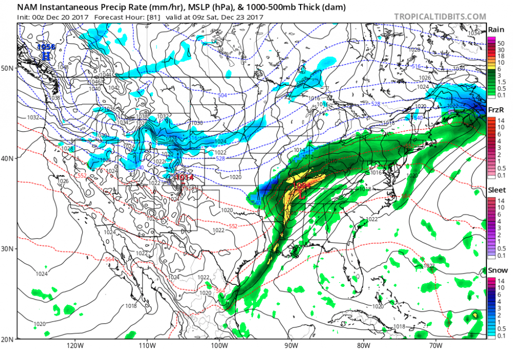
-
MO/KS/AR/OK 2019-2020 Winter Wonderland Discussion
The Waterboy replied to JoMo's topic in Central/Western States
The 12z Canadian also looks very similar. Very positive trend. Models typically don't handle Arctic air masses all that well either. -
MO/KS/AR/OK 2019-2020 Winter Wonderland Discussion
The Waterboy replied to JoMo's topic in Central/Western States
Loving the name change to GSwizzle! Welcome back. You're either our good luck or kiss of death! We shall see. Either way I'm giving you the credit/blame. -
MO/KS/AR/OK 2019-2020 Winter Wonderland Discussion
The Waterboy replied to JoMo's topic in Central/Western States
I prefer the GFS being a little bit south of us this far out. If history repeats itself we will no doubt have the NW shift a few hundred miles. Normally when I'm in the bullseye this far out it shifts to an I-44 storm. Temps on the Canadian look meh but a better track. Lets see what the Euro shows shortly. Hopefully it's better then the 00z run. Still plenty of options on the table.

