The Waterboy
-
Posts
1,008 -
Joined
-
Last visited
Content Type
Profiles
Blogs
Forums
American Weather
Media Demo
Store
Gallery
Everything posted by The Waterboy
-
MO/KS/AR/OK 2019-2020 Winter Wonderland Discussion
The Waterboy replied to JoMo's topic in Central/Western States
Canadian looks solid. -
MO/KS/AR/OK 2019-2020 Winter Wonderland Discussion
The Waterboy replied to JoMo's topic in Central/Western States
Here’s a temp comparison between the 06 GFS and the 12 NAM: Hour. GFS. NAM 60. 38. 35 66. 35. 30 72. 36. 29 78. 39. 31 84. 37. 32 sorry for the ugly format Typing on my phone. -
MO/KS/AR/OK 2019-2020 Winter Wonderland Discussion
The Waterboy replied to JoMo's topic in Central/Western States
I couldn’t agree more. Feb 2011 is a great example of that. Models and NWS were calling for 2-4 inches. I ended up with 17 after being under a heavy band for about 3 hours. I prefer under estimating and then hitting the jackpot. Although that is rare.
-
MO/KS/AR/OK 2019-2020 Winter Wonderland Discussion
The Waterboy replied to JoMo's topic in Central/Western States
Will be interesting to see the next few NAM runs as it gets more into range. Temps are 3-5 degrees colder then the 00z GFS @84. If I recall correctly the NAM tends the handle the cold, shallow air better. Is that right or did I make that up? -
MO/KS/AR/OK 2019-2020 Winter Wonderland Discussion
The Waterboy replied to JoMo's topic in Central/Western States
Welcome aboard. This is the only board I follow. Lots of great people here. GFS run was great. Canadian cuts up to the NE. Couldn’t be more polar opposite from each other. Nothing else that I see supports the Canadian track at this time. -
MO/KS/AR/OK 2019-2020 Winter Wonderland Discussion
The Waterboy replied to JoMo's topic in Central/Western States
Also, anyone have any thoughts on the 18z NAM at 84 hrs vs the 12z GFS/FV3 at 90? LP looks more juiced based on precip and further east but still in northern MX (On the NAM). I know it’s the NAM at 84 which sucks but maybe it’s worth some banter. -
MO/KS/AR/OK 2019-2020 Winter Wonderland Discussion
The Waterboy replied to JoMo's topic in Central/Western States
It’s updated now. I just looked at Bentonville/Rogers, AR (selfishly since that’s where I am) and 23 members have 6 inches or more. A lot of those are over a foot. Anything is still on the table. -
MO/KS/AR/OK 2019-2020 Winter Wonderland Discussion
The Waterboy replied to JoMo's topic in Central/Western States
Is this based on 00z or 12z? Weather.us didn’t have the 12z ensembles updated yet because I wanted to look at the same thing. Still sounds like 50% ish are good. About all we can ask for right now. Survive and advance. -
MO/KS/AR/OK 2019-2020 Winter Wonderland Discussion
The Waterboy replied to JoMo's topic in Central/Western States
Will also be curious to see what the Euro ensembles so show. Hopefully this is a blip and not a trend. If it’s a trend let’s know sooner rather then later so we can focus on something else the next few days! -
MO/KS/AR/OK 2019-2020 Winter Wonderland Discussion
The Waterboy replied to JoMo's topic in Central/Western States
Track still looks solid even though a slight bump north again. Temps were a bit warmer. Hopefully nothing to worry about at this point. Doesn’t the GFS have a warm bias? Hopefully we get a benefit from the snowpack to our north. Canadian wasn’t terrible either. The north shift is slightly concerning. If this continues it’s back to the usual I-44 jackpot. -
MO/KS/AR/OK 2019-2020 Winter Wonderland Discussion
The Waterboy replied to JoMo's topic in Central/Western States
Some of the Euro Ens members are nuts with amounts. Quite a few showing over 8 inches with a handful pushing 12-18. Of course there are also a few showing zero which I willfully choose to ignore. -
MO/KS/AR/OK 2019-2020 Winter Wonderland Discussion
The Waterboy replied to JoMo's topic in Central/Western States
Here’s what NWS Tulsa had to say: While there are still differences in the details, which is expected in the day 6-7 time frame, the GFS and ECMWF both suggest increasing chances for precipitation across the region late next week in advance of a decent southern stream wave. The EC, however, is also more aggressive with the southward push of cold air down the Plains as it has a much more pronounced northern stream wave. This is that dreaded one-two punch that is often seen during big winter storms. While I`m not going to go full boar on this solution, it is prudent to at least introduce the potential for winter weather by day 7 (next Friday). -
MO/KS/AR/OK 2019-2020 Winter Wonderland Discussion
The Waterboy replied to JoMo's topic in Central/Western States
As StormChazer pointed out earlier the GFS solutions over the last few runs seems extremely wonky. Especially the 12z run. Shows snow on the east side with rain further west. That doesn’t seem very plausible outside of an ice storm with a lot of WAA. Althiugh I don’t have the specifics I think the FV3 has been more accurate than the GFS. 7 days out there seems to be good agreement amongst all models and many ensemble members that there will be something to watch. Personally, I prefer when the models don’t pick up on something until 4-5 days out. Tracking this for 8-10 days is maddening. We still have a week to go. -
MO/KS/AR/OK 2019-2020 Winter Wonderland Discussion
The Waterboy replied to JoMo's topic in Central/Western States
Euro looks good. Last 3 runs continue to increase amounts. As usual, I-44 and north is the current bullseye. -
MO/KS/AR/OK 2019-2020 Winter Wonderland Discussion
The Waterboy replied to JoMo's topic in Central/Western States
We’re the Cleveland Browns of WSW’s! They finally got a win this year so hopefully we can too. Even South Texas and North FL have had one in the last year. Not sure if we should laugh, cry, or move. -
MO/KS/AR/OK 2019-2020 Winter Wonderland Discussion
The Waterboy replied to JoMo's topic in Central/Western States
That is some serious blocking. Pretty much the same that Joe Bastardi/Weatherbell’s model has been showing for the winter. -
MO/KS/AR/OK 2019-2020 Winter Wonderland Discussion
The Waterboy replied to JoMo's topic in Central/Western States
It was nice to see snow in November. Temps needed to be a few degrees colder (good call JoMo). But not a bad start. We need the Thursday storm to shift NW by a couple hundred miles. STL may get whacked per the 12z Euro. Any chance of a shift with it coming up out of the gulf/ArkLaTex area? -
MO/KS/AR/OK 2019-2020 Winter Wonderland Discussion
The Waterboy replied to JoMo's topic in Central/Western States
And so it begins. Jeez... Area Forecast Discussion National Weather Service Tulsa OK 927 PM CST Sun Nov 11 2018 ...UPDATE... .DISCUSSION... Precipitation continues to expand from eastern NM through the TX Panhandle and extending across southern KS. A notable uptick in precipitation intensity has been observed across the TX Panhandle with recent reports of thundersnow, and this band of associated forcing will begin to extend eastward overnight with an expected increase in precip into NE OK late tonight. Additionally, the widespread ongoing convection over E TX will gradually lift northward into SE OK later tonight before spreading more east of the forecast area early Monday. Regarding the winter weather potential, the recent operational HRRR runs have verified well with the sfc freezing line, where as the recent 00z NAM showed considerable error across western KS with its 3HR fcst. This trend will be closely followed as the aforementioned NAM run is more aggressive with the freezing line south of I-44 during the the period of strongest lift around mid morning Monday. Also, data trends have been more northward with the mid level dry intrusion which, if verified, would quickly limit the snow potential southeast of Interstate 44 during the day Monday. In typical fashion, Southern Plains winter event are seldom straight forward. The updated forecast will adjust for precip coverage trends through the early morning hours otherwise the overnight forecast remains on track. -
MO/KS/AR/OK 2019-2020 Winter Wonderland Discussion
The Waterboy replied to JoMo's topic in Central/Western States

-
MO/KS/AR/OK 2019-2020 Winter Wonderland Discussion
The Waterboy replied to JoMo's topic in Central/Western States
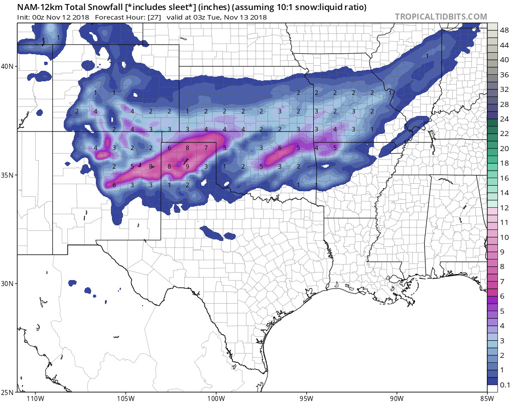
00z NAM looks very similar to 18z. Heaviest band in SW MO/NW AR.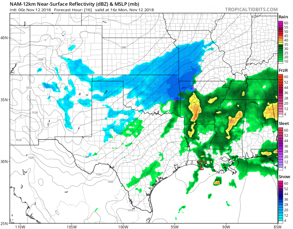
-
MO/KS/AR/OK 2019-2020 Winter Wonderland Discussion
The Waterboy replied to JoMo's topic in Central/Western States
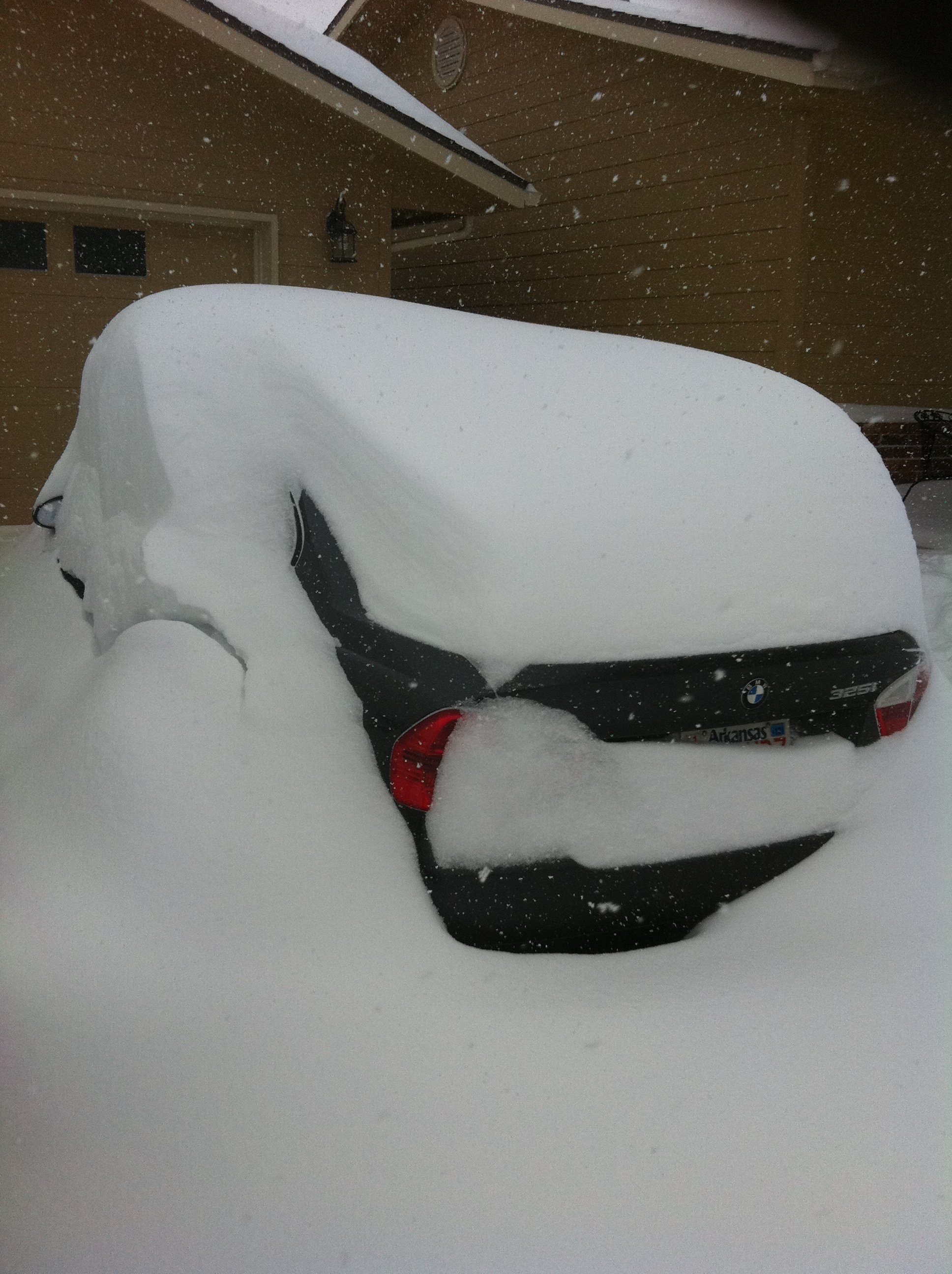
One other thing I left out. Last November snow in Fayetteville was 1996 so we can break a 22 year drought. -
MO/KS/AR/OK 2019-2020 Winter Wonderland Discussion
The Waterboy replied to JoMo's topic in Central/Western States
Here’s is my 2 cents based on 43 years of history living in this area. Nothing earth-shattering here but thought I’d weigh in since you asked. First, some facts: 1. November snowfall in NWAR is very unusual. Since 1949, when NWS started keeping records, measureable snow has fallen only 13 times. 2. 2.0 inches on Monday would put Fay in the top 7 snowiest Nov’s on record. 4 inches would be top 3. Number one is 8 inches back in 1976 so that record should be safe. Historically, our better snowfalls (2+ inches) come in a setup such as this one. Storm track is solid (for now), airmass isn’t super shallow where fz rain is the primary precip type, although thermal profiles are iffy the further south you go, and QPF is decent (0.2-0.4). NWS SGF disco does have some concern over fz drizzle which would suck. It also doesn’t appear like this is cold air chasing precip which is often a problem (cold rain). Models do often tend to underestimate the cold air and how quickly it pushes in. We have continued to see most models uptick in amounts the last 36-48 hours. The ‘ol fly in the ointment is that the storm arrives during the daytime hours. At least we’ll get to see it falling but that may cut down on totals some. Finally, where banding sets up is also a key factor. I would not be surprised to see some area between NE OK, NWAR, SW MO pick up 4 inches. I have had a new snow shovel for 2+ years now and I’ve still not gotten to use it. I finally took the plastic wrap off of it hoping that was the good luck charm we needed. We shall see! WB -
MO/KS/AR/OK 2019-2020 Winter Wonderland Discussion
The Waterboy replied to JoMo's topic in Central/Western States
00z NAM looks great for what it’s worth. -
MO/KS/AR/OK 2019-2020 Winter Wonderland Discussion
The Waterboy replied to JoMo's topic in Central/Western States
12z Canadian for the win again. Looks like a trend! -
MO/KS/AR/OK 2019-2020 Winter Wonderland Discussion
The Waterboy replied to JoMo's topic in Central/Western States
Looks like the 12z CMC has this as well. And the 06z FV3 to a lesser degree. Maybe something to watch. Im sure you’ll update us again after the 12z Euro.