The Waterboy
-
Posts
1,008 -
Joined
-
Last visited
Content Type
Profiles
Blogs
Forums
American Weather
Media Demo
Store
Gallery
Everything posted by The Waterboy
-
MO/KS/AR/OK 2022-2023 Winter Discussion
The Waterboy replied to JoMo's topic in Central/Western States
If the uptick in the Globals turns out to come to fruition I’d give two thumbs up to the ICON who has held steady with that solution for the last few days. -
MO/KS/AR/OK 2022-2023 Winter Discussion
The Waterboy replied to JoMo's topic in Central/Western States
I think we’re all too nervous! Regardless of the total amount of snow this storm will be crazy with the winds and temps. Will definitely be one to remember. My hope is that we are issued a blizzard warning. Pretty sure I’ve never been under one of those before in all my years. Keep the updates coming!!! -
MO/KS/AR/OK 2022-2023 Winter Discussion
The Waterboy replied to JoMo's topic in Central/Western States
18z RGEM is slightly improved further south as well. We need that trend to continue. Right now I would say Wichita to Joplin look to be in decent shape. NW AR and Tulsa are borderline. Anything further south and west of that is suspect at best. -
MO/KS/AR/OK 2022-2023 Winter Discussion
The Waterboy replied to JoMo's topic in Central/Western States
For what it’s worth (which may not be much) the ICON has continued to trend more in our favor over the last 5 runs. The 18z was actually pretty solid. -
MO/KS/AR/OK 2022-2023 Winter Discussion
The Waterboy replied to JoMo's topic in Central/Western States
The CMC wasn’t terrible. It actually shifted SW a bit. -
MO/KS/AR/OK 2022-2023 Winter Discussion
The Waterboy replied to JoMo's topic in Central/Western States
Agreed, especially for you in LR. That type of track could doom some to the dreaded dry slot. -
MO/KS/AR/OK 2022-2023 Winter Discussion
The Waterboy replied to JoMo's topic in Central/Western States
I know we’re all going to laugh hysterically at what I’m about to say, but the 18z NAM at 84 looks juicy. Snow already breaking out across a lot of OK. -
MO/KS/AR/OK 2022-2023 Winter Discussion
The Waterboy replied to JoMo's topic in Central/Western States
Welcome to the forum!!! Hopefully this one will be a nice “Welcome to the Midwest” for you. -
MO/KS/AR/OK 2022-2023 Winter Discussion
The Waterboy replied to JoMo's topic in Central/Western States
12z GFS looks great! As JoMo said last night, the Kuchera looks solid and can’t be ruled out due to such cold temps. Now we need the Euro to continue to trend in our favor. -
MO/KS/AR/OK 2022-2023 Winter Discussion
The Waterboy replied to JoMo's topic in Central/Western States
00z GFS looks like an unorganized hot mess. -
MO/KS/AR/OK 2022-2023 Winter Discussion
The Waterboy replied to JoMo's topic in Central/Western States
I was texting with Dan Skoff about this exact thing yesterday. He thinks the deterministic runs struggle that far out with the details. Does anyone still have access to the ensembles? The system on the 23rd looks interesting. 12z GFS was more robust with the wave and explodes it just east of us in to the SE. Should be a fun ride. -
MO/KS/AR/OK 2022-2023 Winter Discussion
The Waterboy replied to JoMo's topic in Central/Western States
00z GFS run has stupid cold on Christmas!!!! Brrrrr. That would be festive for sure. -
MO/KS/AR/OK 2022-2023 Winter Discussion
The Waterboy replied to JoMo's topic in Central/Western States
Same here in Bentonville. Maybe an inch. Big flakes at times. Decent amount of melting along the way. Definitely unexpected for mid-November. Would have been probably 2-4” in mid-January. Hopefully this is a great sign for the rest of winter. -
MO/KS/AR/OK 2022-2023 Winter Discussion
The Waterboy replied to JoMo's topic in Central/Western States
Decent sized flakes reported falling in Fayetteville with a dusting already on cars/elevated surfaces. -
MO/KS/AR/OK 2021-2022 Winter Discussion
The Waterboy replied to JoMo's topic in Central/Western States
3 1/2” on a plastic table.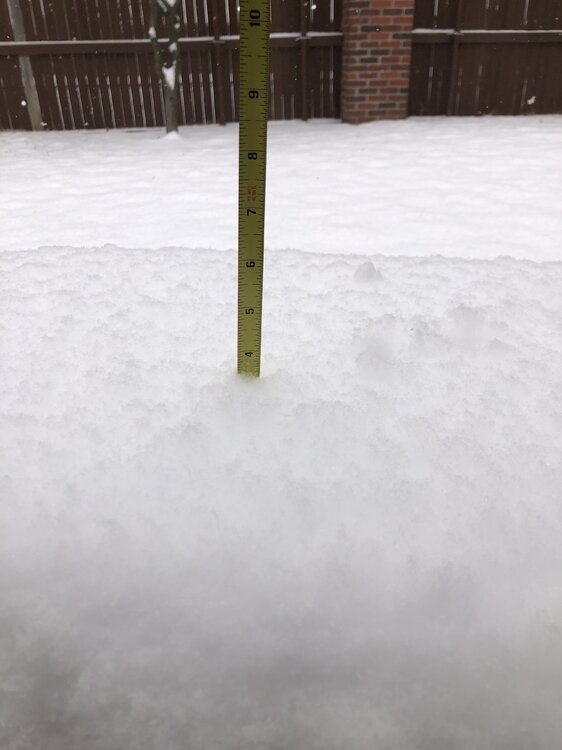
-
MO/KS/AR/OK 2021-2022 Winter Discussion
The Waterboy replied to JoMo's topic in Central/Western States
Decent mid-March snow here. Very heavy, wet flakes. Probably 1-1 1/2 inches so far in Bentonville/Bella Vista. Hard to say for sure with the sun angle/melting. -
MO/KS/AR/OK 2021-2022 Winter Discussion
The Waterboy replied to JoMo's topic in Central/Western States
18z GFS was a big hit for some. -
MO/KS/AR/OK 2021-2022 Winter Discussion
The Waterboy replied to JoMo's topic in Central/Western States
It will be interesting to see if the Super Bowl Sunday wave can turn into anything. The 12z ICON is the strongest. Euro/CMC show it too. 12z GFS didn’t but the 18z does. Maybe something to watch while things are boring for the next week. -
MO/KS/AR/OK 2021-2022 Winter Discussion
The Waterboy replied to JoMo's topic in Central/Western States
The latest RAP and HRRR both show the wave doesn’t get into NWA until 10 or 11 tonight. The next 2-3 hours should be pretty light if anything for us. -
MO/KS/AR/OK 2021-2022 Winter Discussion
The Waterboy replied to JoMo's topic in Central/Western States
Still sleet here. It’s been snowing 10 miles north and 10 miles west of me for the last hour. This is a game of inches. -
MO/KS/AR/OK 2021-2022 Winter Discussion
The Waterboy replied to JoMo's topic in Central/Western States
Same in Bentonville. Radar shows heavy snow just south and west of Tulsa. -
MO/KS/AR/OK 2021-2022 Winter Discussion
The Waterboy replied to JoMo's topic in Central/Western States
I didn’t see it on the radar either which was very odd. It was just enough to make some of the corners of rooftops white. -
MO/KS/AR/OK 2021-2022 Winter Discussion
The Waterboy replied to JoMo's topic in Central/Western States
MoWeatherGuy, similar to what StormDragon said above we just had short “burst” of snow showers within the last half hour. Hopefully that’s a positive sign that 850 temps are cold enough for all snow. We shall see… -
MO/KS/AR/OK 2021-2022 Winter Discussion
The Waterboy replied to JoMo's topic in Central/Western States
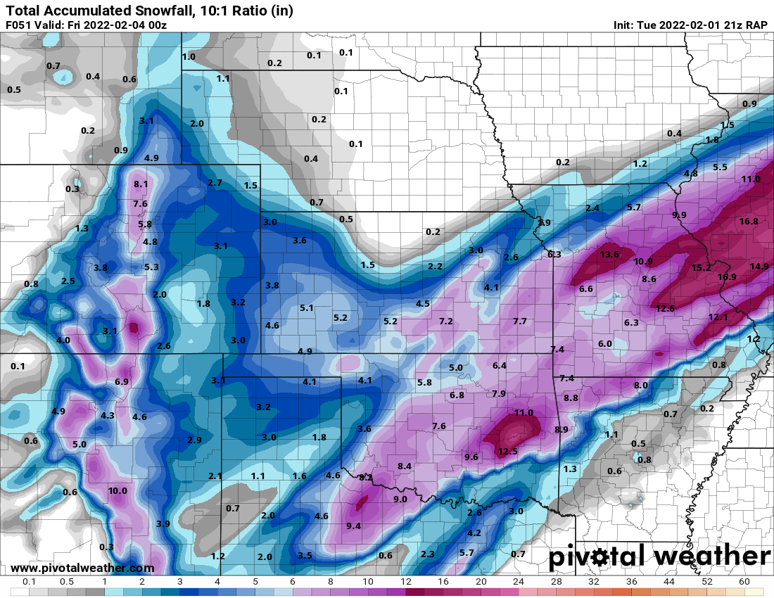
I’ll take the 03z RAP. -
MO/KS/AR/OK 2021-2022 Winter Discussion
The Waterboy replied to JoMo's topic in Central/Western States
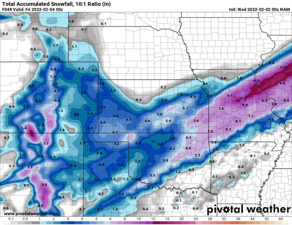
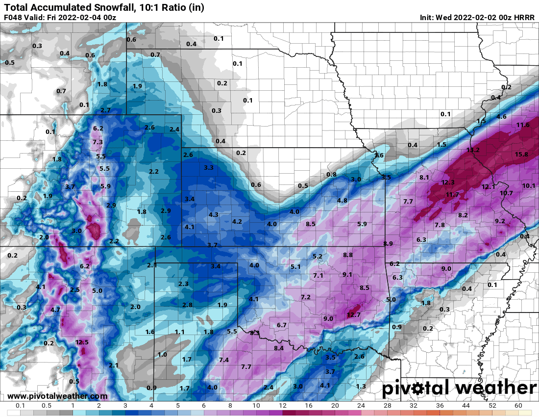
Still significant differences between the NAM, HRRR, and RAP for Eastern/SE OK and Western AR.