The Waterboy
-
Posts
1,008 -
Joined
-
Last visited
Content Type
Profiles
Blogs
Forums
American Weather
Media Demo
Store
Gallery
Everything posted by The Waterboy
-
MO/KS/AR/OK 2020-2021 "Winter" Discussion
The Waterboy replied to JoMo's topic in Central/Western States
For sure! -
MO/KS/AR/OK 2020-2021 "Winter" Discussion
The Waterboy replied to JoMo's topic in Central/Western States
^ YES!!! -
MO/KS/AR/OK 2020-2021 "Winter" Discussion
The Waterboy replied to JoMo's topic in Central/Western States
That’s right! Totally forgot that. No, I don’t have a subscription. That explains a majority of it. I like the WB map much better anyway! -
MO/KS/AR/OK 2020-2021 "Winter" Discussion
The Waterboy replied to JoMo's topic in Central/Western States
This map looks completely different than the Pivotal Kuchera map. And by a lot. Pivotal shows the heaviest amounts up through Central Ark and 10” for OKC. How are the two off by so much? -
MO/KS/AR/OK 2020-2021 "Winter" Discussion
The Waterboy replied to JoMo's topic in Central/Western States
I don’t fundamentally disagree with your statement. However, this will be happening with very cold temps so I would say it’s more plausible than normal. In a typical situation I don’t look at Kuchera ever. -
MO/KS/AR/OK 2020-2021 "Winter" Discussion
The Waterboy replied to JoMo's topic in Central/Western States
Can someone post the 06 v16 clown map? It’s insanity but fun to look at. 3 feet for Tulsa. -
MO/KS/AR/OK 2020-2021 "Winter" Discussion
The Waterboy replied to JoMo's topic in Central/Western States
It’s hard not to already be excited about the possibilities even though there are plenty of opportunities to screw us over. The GFS has stood its ground since at least Monday. Maybe we can all breathe a bit easier in about 48 hours once this gets sampled. I’ll admit it, I’m giddy... -
MO/KS/AR/OK 2020-2021 "Winter" Discussion
The Waterboy replied to JoMo's topic in Central/Western States
06 GFSv16 through 168 went bonkers! -
MO/KS/AR/OK 2020-2021 "Winter" Discussion
The Waterboy replied to JoMo's topic in Central/Western States
06z GFSv16 finally out to be 108 on Pivotal. Still looks solid. Looks better than the 06z GFS. The storm is just getting to AR/MO at 96. Having issues on my phone posting the map. -
MO/KS/AR/OK 2020-2021 "Winter" Discussion
The Waterboy replied to JoMo's topic in Central/Western States
Looks like the GFSv16 is having issues running again. It’s been stuck on hr90 for a while now. -
MO/KS/AR/OK 2020-2021 "Winter" Discussion
The Waterboy replied to JoMo's topic in Central/Western States
I wonder if this takes into consideration the higher 15-20:1 ratios. Any idea since it’s a blend? -
MO/KS/AR/OK 2020-2021 "Winter" Discussion
The Waterboy replied to JoMo's topic in Central/Western States
GFS has the Wed/Thurs storm too. -
MO/KS/AR/OK 2020-2021 "Winter" Discussion
The Waterboy replied to JoMo's topic in Central/Western States
I’m right there with you. Optimism is the name of the game for now. Plenty of time to be pissed later if this all falls apart. -
MO/KS/AR/OK 2020-2021 "Winter" Discussion
The Waterboy replied to JoMo's topic in Central/Western States
I was just thinking that too but then I told myself it’s the NAM at 84. Ha! Regardless, very good look if we extrapolate it out the next 3 or 4 frames. -
MO/KS/AR/OK 2020-2021 "Winter" Discussion
The Waterboy replied to JoMo's topic in Central/Western States
18z GFS going to be insane again -
MO/KS/AR/OK 2020-2021 "Winter" Discussion
The Waterboy replied to JoMo's topic in Central/Western States
I’m nervous every time a new run starts... -
MO/KS/AR/OK 2020-2021 "Winter" Discussion
The Waterboy replied to JoMo's topic in Central/Western States
This is just through 150. More falls after that. I’m sure you’ll repost the update once it finishing running. -
MO/KS/AR/OK 2020-2021 "Winter" Discussion
The Waterboy replied to JoMo's topic in Central/Western States
And the Canadian explodes for the Wed/Thurs system. Wow!!!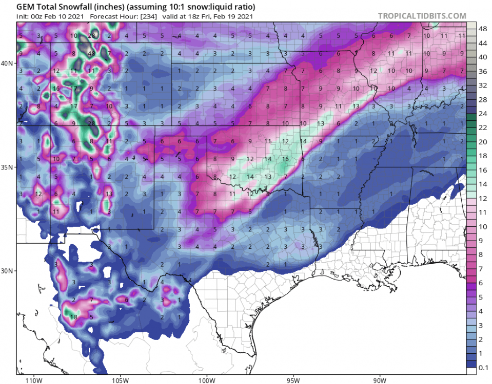
-
MO/KS/AR/OK 2020-2021 "Winter" Discussion
The Waterboy replied to JoMo's topic in Central/Western States
In my opinion things still look good for all of us. The GFS has been the most consistent run to run by far and the V16 is still a crush for all. The Canadian is all over the place but at least it has the Mon/Tues storm now. Even the NAM at 78-84 (Ha!!!) even took a step in the right direction. That’s all the optimism I have for now! -
MO/KS/AR/OK 2020-2021 "Winter" Discussion
The Waterboy replied to JoMo's topic in Central/Western States
Pivotal Weather -
MO/KS/AR/OK 2020-2021 "Winter" Discussion
The Waterboy replied to JoMo's topic in Central/Western States
GFSv16 still looks solid for Sat/Sun -
MO/KS/AR/OK 2020-2021 "Winter" Discussion
The Waterboy replied to JoMo's topic in Central/Western States
I heard this on the news at 6. I was in Springdale for a high school basketball game until about 5:45. It was only drizzle then so I must have just missed it. -
MO/KS/AR/OK 2020-2021 "Winter" Discussion
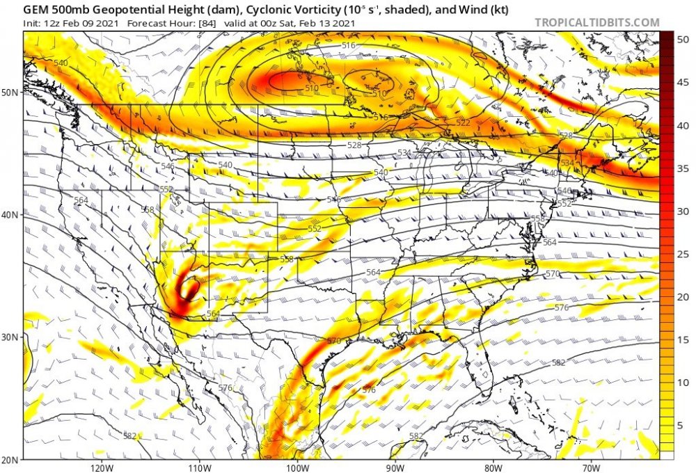
The Waterboy replied to JoMo's topic in Central/Western States
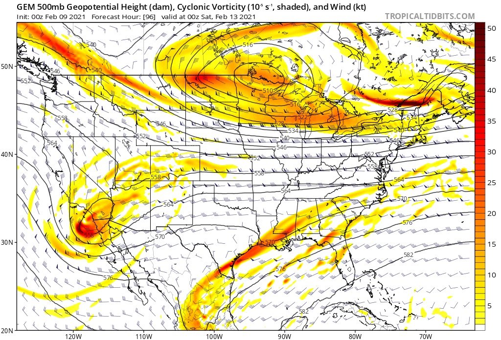
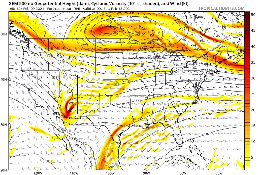
500mb on the Canadian is definitely an improvement towards the GFS. Very similar through 96 then it starts to differ. I’d call it a step in the right direction especially when comparing the Canadian12z vs the 00z. 00z with wave near San Diego 12z in AZ.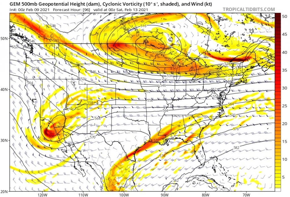
-
MO/KS/AR/OK 2020-2021 "Winter" Discussion
The Waterboy replied to JoMo's topic in Central/Western States
GFS out to 96 isn’t backing down on the cold. We’ll see shortly if the weekend storm is still there. -
MO/KS/AR/OK 2020-2021 "Winter" Discussion
The Waterboy replied to JoMo's topic in Central/Western States
Looks like the front cuts just north of you and those of us in NW AR. The shallow cold air always has such a hard time pushing over the mountains so we’ll stay between 30-34ish while others a few miles north are in the 20’s. Per the HRRR, Bentonville isn’t below 32 for 12 more hours.