Violentweatherfan
-
Posts
3,677 -
Joined
-
Last visited
Content Type
Profiles
Blogs
Forums
American Weather
Media Demo
Store
Gallery
Everything posted by Violentweatherfan
-

January 25-26 Winter Storm Potential
Violentweatherfan replied to Ralph Wiggum's topic in Philadelphia Region
NYC forum posted this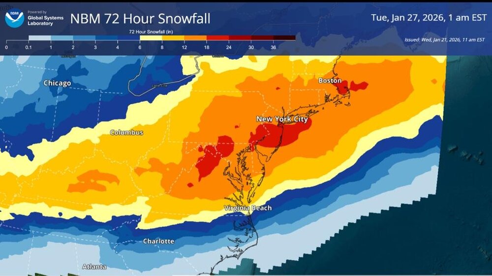
-
January 25-26 Winter Storm Potential
Violentweatherfan replied to Ralph Wiggum's topic in Philadelphia Region
Anyone remember a SWFE with redevelopment off the coast? PPDII is as close as you are gonna get but there was no coastal redevelopment -
January 25-26 Winter Storm Potential
Violentweatherfan replied to Ralph Wiggum's topic in Philadelphia Region
Per WPC the northern shift could be a mirage. Due to the intensity of the phasing of the northern jet and the sub tropical jet. WPC is confident that the interaction between streams is slightly over amplified and the trend won’t be so northern and will adjust with better sampling as the week progresses -
January 25-26 Winter Storm Potential
Violentweatherfan replied to Ralph Wiggum's topic in Philadelphia Region
It can happen, PDII had mixing issues. Actually cut accumulations by a couple of inches -
January 25-26 Winter Storm Potential
Violentweatherfan replied to Ralph Wiggum's topic in Philadelphia Region
Temps are all over the place. On the way home from work my temperature reading in my vehicle bounced around several times by 3°
-
January 25-26 Winter Storm Potential
Violentweatherfan replied to Ralph Wiggum's topic in Philadelphia Region
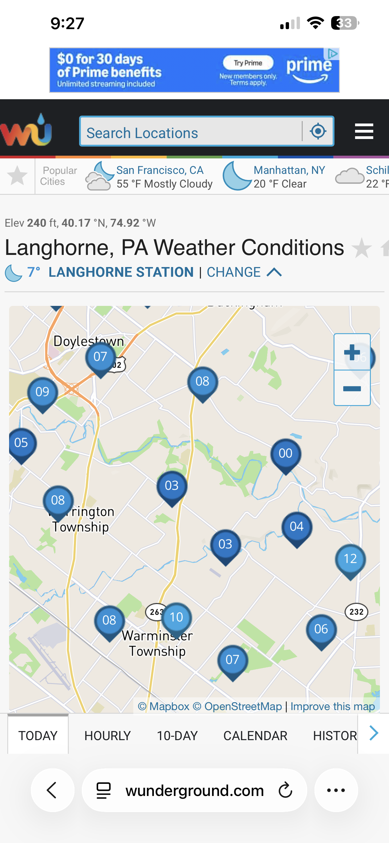
Yeah, when I posted that I saw what 6° then it dropped to five and then I looked at Langhorne and they were at 9°. Maybe a different station. -
January 25-26 Winter Storm Potential
Violentweatherfan replied to Ralph Wiggum's topic in Philadelphia Region
I know all of our focus has been on tracking this event, but does everyone realize it’s only 5 degrees outside right now -
January 25-26 Winter Storm Potential
Violentweatherfan replied to Ralph Wiggum's topic in Philadelphia Region
Nice to see you stop by Roger -
January 25-26 Winter Storm Potential
Violentweatherfan replied to Ralph Wiggum's topic in Philadelphia Region
Actually weak La Niña winters are great for big winter snows -
January 25-26 Winter Storm Potential
Violentweatherfan replied to Ralph Wiggum's topic in Philadelphia Region
I think the GFS is what it is because of how it’s handling the cold air. Therefore suppressed, how often do these super cold temps verify. Rarely, so I think the GFS will come north -
E PA/NJ/DE Winter 2025-26 Obs/Discussion
Violentweatherfan replied to LVblizzard's topic in Philadelphia Region
Wanted feedback, it’s all good -
E PA/NJ/DE Winter 2025-26 Obs/Discussion
Violentweatherfan replied to LVblizzard's topic in Philadelphia Region
How is this for a title, SWFE[southwest flow event] or WHIFF event January 24/24 2026 -
E PA/NJ/DE Winter 2025-26 Obs/Discussion
Violentweatherfan replied to LVblizzard's topic in Philadelphia Region
I think it’s time for a thread, I’ll start it once I think of a nice title -
E PA/NJ/DE Winter 2025-26 Obs/Discussion
Violentweatherfan replied to LVblizzard's topic in Philadelphia Region
I-95 dry slotted in 2016 as well. Lost quite a bit of accumulation -
E PA/NJ/DE Winter 2025-26 Obs/Discussion
Violentweatherfan replied to LVblizzard's topic in Philadelphia Region
Can you check the Skew T and see what the temps are for the Dendritic Growth Zone. From what I understand too cold can impact accumulation -
E PA/NJ/DE Winter 2025-26 Obs/Discussion
Violentweatherfan replied to LVblizzard's topic in Philadelphia Region
This would be an overrunning event, as of now there doesn’t appear to be any redevelopment off the coast. Most Miller B storms are from clippers that redeveloped off the Carolinas. The concern is the cold air mass will keep the moisture flow south. Storms follow the path of least resistance. I do believe the cold is overdone and the models are keeping most of the precip south of us -
E PA/NJ/DE Winter 2025-26 Obs/Discussion
Violentweatherfan replied to LVblizzard's topic in Philadelphia Region
I the cold is overdone and the model runs today are reacting to it -
E PA/NJ/DE Winter 2025-26 Obs/Discussion
Violentweatherfan replied to LVblizzard's topic in Philadelphia Region
It’s only Monday, I like the set up. We’re getting snow, it will only be a matter of how much -
E PA/NJ/DE Winter 2025-26 Obs/Discussion
Violentweatherfan replied to LVblizzard's topic in Philadelphia Region
Maybe we should make a thread, all other sub forums did -
E PA/NJ/DE Winter 2025-26 Obs/Discussion
Violentweatherfan replied to LVblizzard's topic in Philadelphia Region
PDII was forecast to be a hit by five days out. Anyway, the MJO will be moving into phase 7 and the NAO will be somewhat negative. I don’t see any blocking. I’d like to see the the cold air mass dig a little deeper and we’d be in business -
E PA/NJ/DE Winter 2025-26 Obs/Discussion
Violentweatherfan replied to LVblizzard's topic in Philadelphia Region
MJO is moving into a more favorable phase 7/8 which also is good for significant snowstorms -
Storm potential January 17th-18th
Violentweatherfan replied to WeatherGeek2025's topic in New York City Metro
The MJO will be in a more favorable phase by then -
Storm potential January 17th-18th
Violentweatherfan replied to WeatherGeek2025's topic in New York City Metro
Also the MJO will be in phase 6 which does not favor snow for the east coast -
E PA/NJ/DE Winter 2025-26 Obs/Discussion
Violentweatherfan replied to LVblizzard's topic in Philadelphia Region
MJO forecast was forecast for this time period to be in phase six, and is. It won’t be any where near phase eight until the end of this month -
On the way home from work back to Jamison it’s snowing too