LakePaste25
-
Posts
1,120 -
Joined
-
Last visited
Content Type
Profiles
Blogs
Forums
American Weather
Media Demo
Store
Gallery
Everything posted by LakePaste25
-

2026-2027 Super El Nino
LakePaste25 replied to Stormchaserchuck1's topic in Weather Forecasting and Discussion
Agreed. La Nina’s generally being drier east of the appalachians would probably be a true statement however. Northern stream dominated systems that get shredded by the mountains. -
Correct, March 2012 probably becomes a once per generation event at most under 2C. Would need way more warming for that to even get a return interval of once per decade. Unfortunately for winter weenies, December 2015 style winter warm events do become far more frequent under 2C. Once per decade at least.
-
2026-2027 Super El Nino
LakePaste25 replied to Stormchaserchuck1's topic in Weather Forecasting and Discussion
The reverse of this also exists. A nino-style pacific jet extension that blasts warm air into Canada and the E US typically correlates to a weak +PNA. -
i’ll just agree to disagree that the weak nino classification itself matters more than the SSTAs. 18-19, 19-20 were also weak ninos. yea, i agree that weak ninos, on average, tend to have the favorable central pacific SSTAs that produces good winters for boston. also when i say “traditional standards” i’m referring to canonical east based.
-
14-15 was hardly a nino and didn’t really fit the traditional standards of one (if it did then DCA would have had a far better season than BOS). the reason it was less of an analog IMO was because it had a warm pool spanning into Nino 4 and Nino 3.4 which really helps with late winter -epo development. just how i look at it, people can disagree here.
-
one thing i learned is that every springlike warm pattern is just like Feb 2018 and March 2012. Every Nina is just like 1995-1996, and every Nino will be like 1976-1977, 2004-2005, and 2014-2015
-
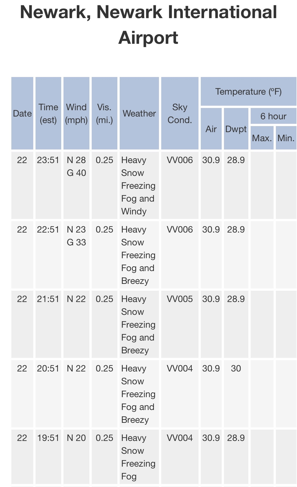
Sustained blizzard conditions (so far) at EWR.

-
Who is ready for more winter at the end of March?
-
cold arctic/warm mid latitudes pattern we saw back in 2020.
-
yeah i agree with this. i might have recency bias but getting a somewhat cold and snowy march here tends to correlate to a warm april, and the other way around: 2025: torch in march, cold rainy april 2024: very late season cold/snowy after mid march, record warm april 2023: SSW leading to cold and snowy march, a stretch of very nice weather (including 80+ days) in april 2022: little snow in march, cool and rainy april the all-timer was of course the historic march 2012 warmth which caused record earliest leaf-out, then lead to multiple freezes in april that damages a lot of plants and other crops. i’d be happy with a repeat of spring 2024, but that was a strong nino.
-
i’m fine with spring warmth. 40s feel like heaven here after that cold snap. obviously can’t really say i am done with snow here though because march can be quite wintery here in the great lakes.
-
That baja ridging is going to be key if we are getting any help with blocking on the atlantic side.
-
May be lingering effects, but it’s safe to say that La niña is done for.
-
What??
-
All 2m temp forecasts are the same though. It’s just how the anomalies are interpreted. Would agree that EPS are running slightly cold of GEFS/GEPS suites.
-
Happy to dig deeper into this. I always thought actual 2m temps were universal vs. the differing anomaly datasets.
-
Who said there was going to be a torch in Feb? Seems like a straw man.
-
I believe the ECMWF native site is still using 1981-2010 climate normals, while the wxbell site is using the warmer 1991-2020 normals. The actual 2m temps should be the same, but the newer 1991-2020 normals will appear colder because the baseline is warmer, which is what we should expect in a warmer climate. Raw 2m temps are produced by the models themselves. It’s up to what dataset you want to use for the anomalies.
-
I highlighted a colder risk for the last third of february this morning and gave reasons…low-medium confidence for now. I’m also a little too regionally biased/focused with this because even if the blocking pattern breaks down and a cutter pattern develops, i tend to be in a better spot being 300-400 miles west of I-95 in the eastern great lakes.
-
More serviceable after mid month due to it flipping from a -WPO induced -PNA rather than a +WPO jet extension induced -PNA. Restores true cold into Canada. It won’t be like December where the -WPO alone will be enough due to shorter wavelengths, but if other factors align such as better angle of -PNA troughing and atlantic/arctic blocking, then it’s absolutely a decent pattern to work with for the northern tier. It’s why i put the last third of Feb as colder risks, but more TBD.
-
If I were to break Feb roughly into thirds, this is how I would lay it out: First third (1-10th): Very cold/well below normal Second third: (11-20th): Milder risks, but not well above normal. -PNA Third (21-28th): Potentially return to colder than normal with established -WPO + blocking (this period more TBD). Not nearly as cold as the first third. Still -PNA
-
Feb 2020 had above average snowfall here (24.9”, Feb average is 20”). The worst Feb here was 2024 (strong nino), which featured a paltry 0.8”
-
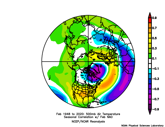
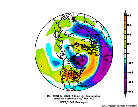
I do think an ENSO Feb mismatch in the NE is plausible when it comes to the surface temps vs. H5. Nina-like aloft at 500mb, but Nino-like below normal surface temps.
-
I haven’t seen any +PNA Feb predictions on twitter, even from BAM. Seeing a ton of “look, it’s not a torch posts” which is weird because I also can’t find any reputable post that predicted a torch.
-
Feb Nina -PNA is serviceable here. Averages around 50% of normal (10”). Would say that weak-warm +ENSO Feb performs the best here, however. Such as in 2020, 2019, 2015, 2007.