LakePaste25
-
Posts
1,120 -
Joined
-
Last visited
Content Type
Profiles
Blogs
Forums
American Weather
Media Demo
Store
Gallery
Everything posted by LakePaste25
-

2026-2027 Super El Nino
LakePaste25 replied to Stormchaserchuck1's topic in Weather Forecasting and Discussion
Your chart actually shows the flaws of MEI quite well. It’s only looking for one type/configuration of Nino. You can see how it significantly lagged the 2023-2024 Nino because of this. It may very well be true that the MEI will rate higher this time due to the +PMM, but you still have the -PDO working against it. -
2026-2027 Super El Nino
LakePaste25 replied to Stormchaserchuck1's topic in Weather Forecasting and Discussion
beware of using the MEI. During Super Nino events, it tends to be a weenie index and is biased towards central pacific events. RONI vs. ONI are the bread and butter for this IMO. -
2026-2027 Super El Nino
LakePaste25 replied to Stormchaserchuck1's topic in Weather Forecasting and Discussion
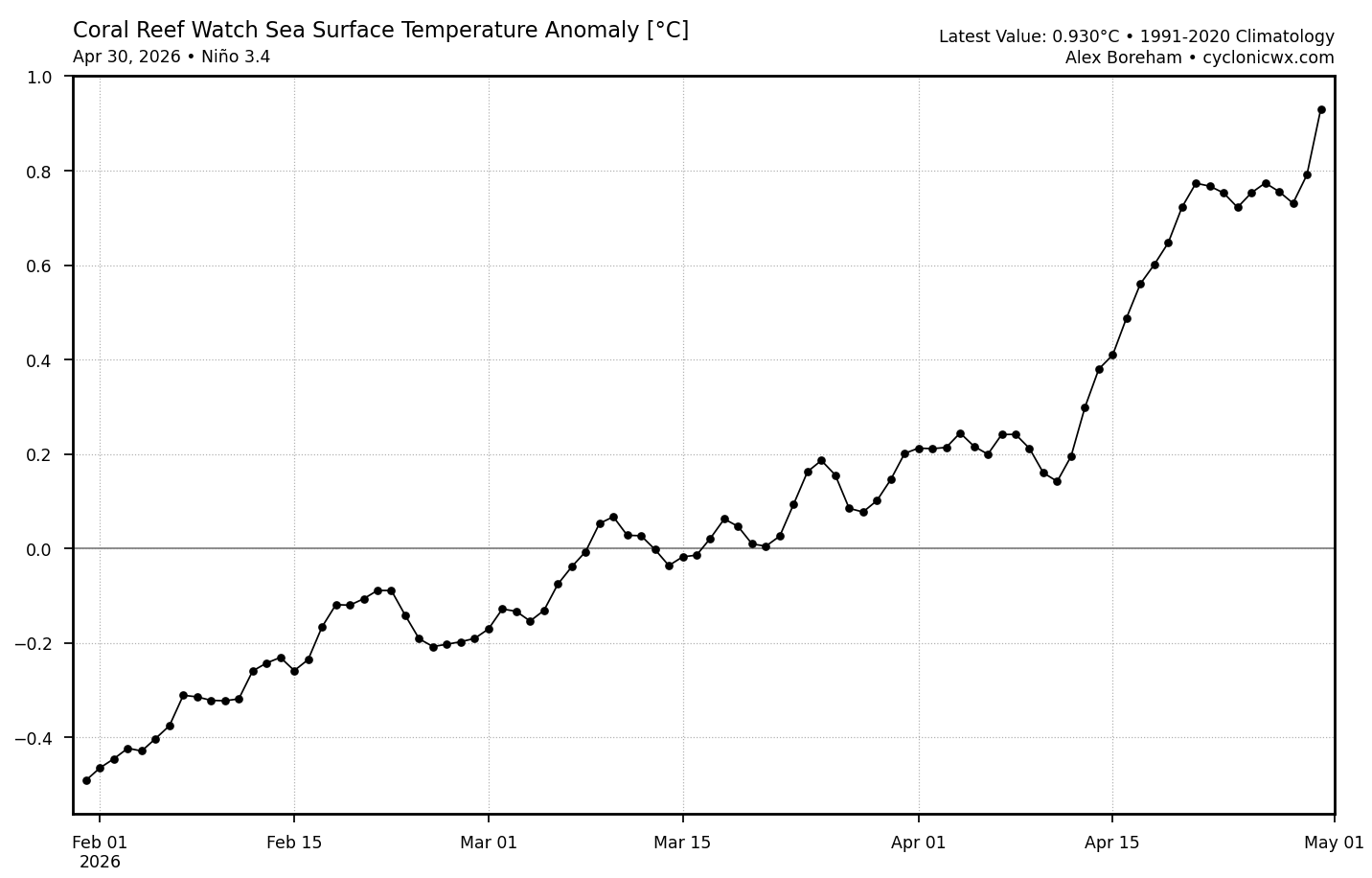
Not a huge lag between ONI and RONI at the moment (roughly 0.3C):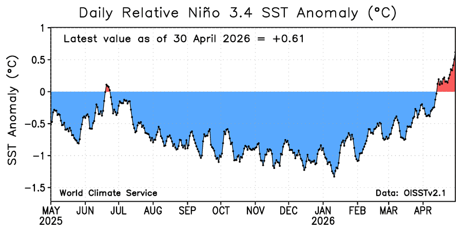

-
2026-2027 Super El Nino
LakePaste25 replied to Stormchaserchuck1's topic in Weather Forecasting and Discussion
The reason many of the big mets on twitter are going with super and east based is because most Ninos that have started out the way this one is starting out have gone that way, so they’re not just doing it because they have some inherent warm bias - they have data to back it up. But the thing about meteorology (and the broader sciences) is that past data is only right until otherwise proven wrong. -
2026-2027 Super El Nino
LakePaste25 replied to Stormchaserchuck1's topic in Weather Forecasting and Discussion
This is where I’m at as well. Until I see a more supportive evidence in the SSTA/MJO/WWB evolution that supports a CANSIPS-like outcome, I’m taking it with a grain of salt. Modelology vs. Meteorology. -
2026-2027 Super El Nino
LakePaste25 replied to Stormchaserchuck1's topic in Weather Forecasting and Discussion
Even if a 97-98 SSTA replica was on the way, I would still predict a pacific jet dominated winter with potential for 1-2 big coastal or SE snowstorms later in the winter. These are individual big ticket events that cannot be predicted months, or even several weeks in advance. -
2026-2027 Super El Nino
LakePaste25 replied to Stormchaserchuck1's topic in Weather Forecasting and Discussion
I think when you look at December 2015 alone, it was an anomalous configuration for a super Nino. The lack of a strong southern stream in the SE US allowed storms to cut, so you had both this bad combo of a pac jet extension to the west coast combined with a Nina-like SE ridge configuration. Compare this to December 1997 where you have a strong southern stream extending all the way across the southern US, which is the more canonical Nino outcome. Just giving 1 example of how we can do better than 15-16.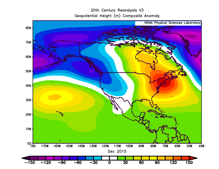
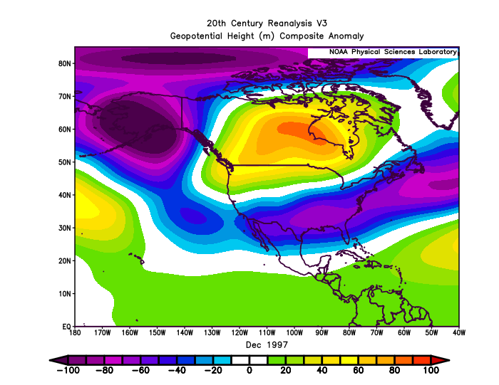
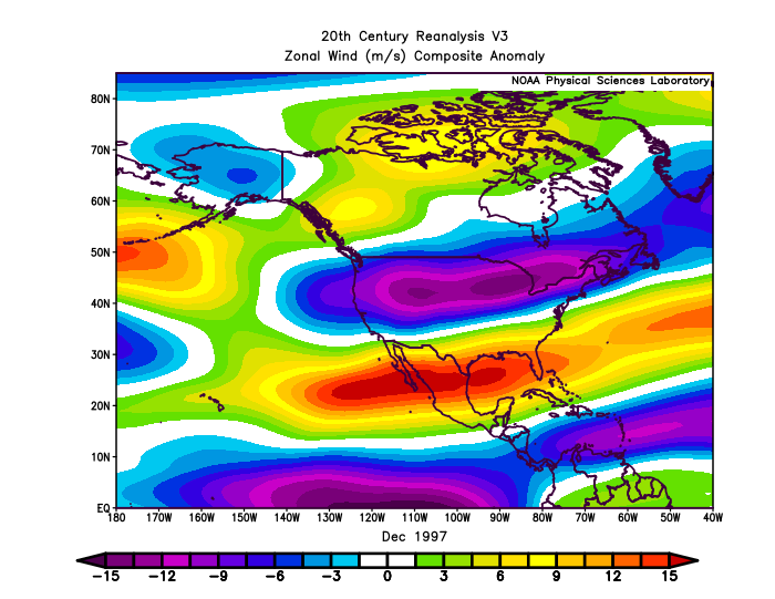
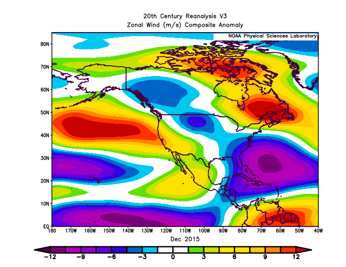
-
2026-2027 Super El Nino
LakePaste25 replied to Stormchaserchuck1's topic in Weather Forecasting and Discussion
If it is not going to snow in December then I hope we get a December 2015 type outcome so I can enjoy the nice weather outdoors. December 2023 was not ideal, because it was still hostile for snow but it was in the 30s most days. -
2026-2027 Super El Nino
LakePaste25 replied to Stormchaserchuck1's topic in Weather Forecasting and Discussion
All super ninos have featured below normal snowfall here - a 15-16 outcome vs 97-98 doesn’t make a difference for me as they both had roughly 60-80” on the season. There will always be brief cold shots on the backside of winter and sometimes even very short ones in december if we’re lucky, although december is typically the most hostile. -
2026-2027 Super El Nino
LakePaste25 replied to Stormchaserchuck1's topic in Weather Forecasting and Discussion
Yeah. I fully believe mostly warm temps and strong or super. I see the difference between basin wide vs EP as “do we get a couple of more cold intrusions on the back side of winter to try to get something to phase with that supercharged southern stream, or is it extremely limited like 97-98?” It’s really not a question that can answered by even the most skilled mets this early on IMO. -
2026-2027 Super El Nino
LakePaste25 replied to Stormchaserchuck1's topic in Weather Forecasting and Discussion
Yup. 15-16 is a good example of a super that starts out east-based before going basin wide approaching winter. -
Seriously, can we get out of the stone age and allow “x” links so we don’t need to change them to twitter for them to embed? I know this is possible because there are other invision forums that have updated to allow this.
-
2026-2027 Super El Nino
LakePaste25 replied to Stormchaserchuck1's topic in Weather Forecasting and Discussion
Anyone have any summer analogs for this (el nino standing wave competing with e atlantic/african standing wave)? -
2026-2027 Super El Nino
LakePaste25 replied to Stormchaserchuck1's topic in Weather Forecasting and Discussion
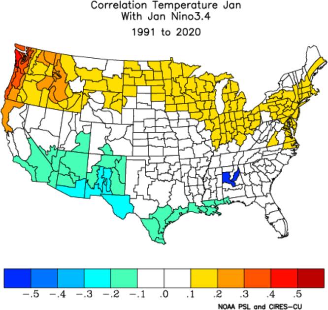
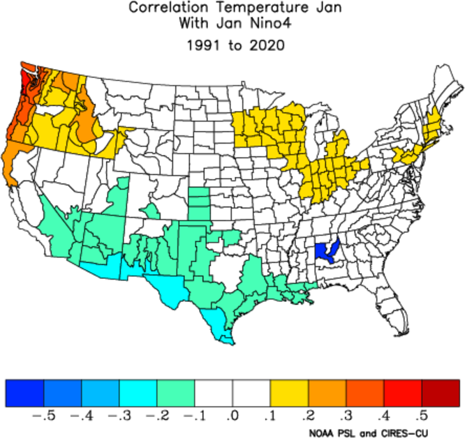
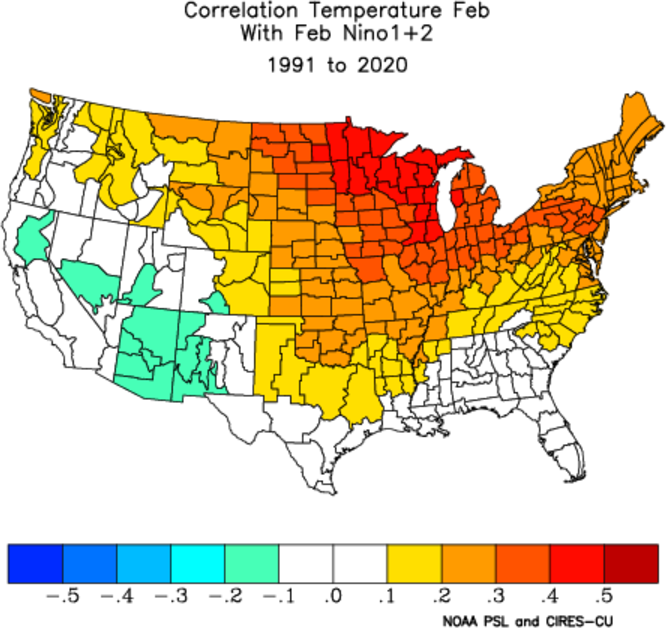
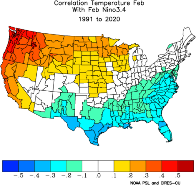
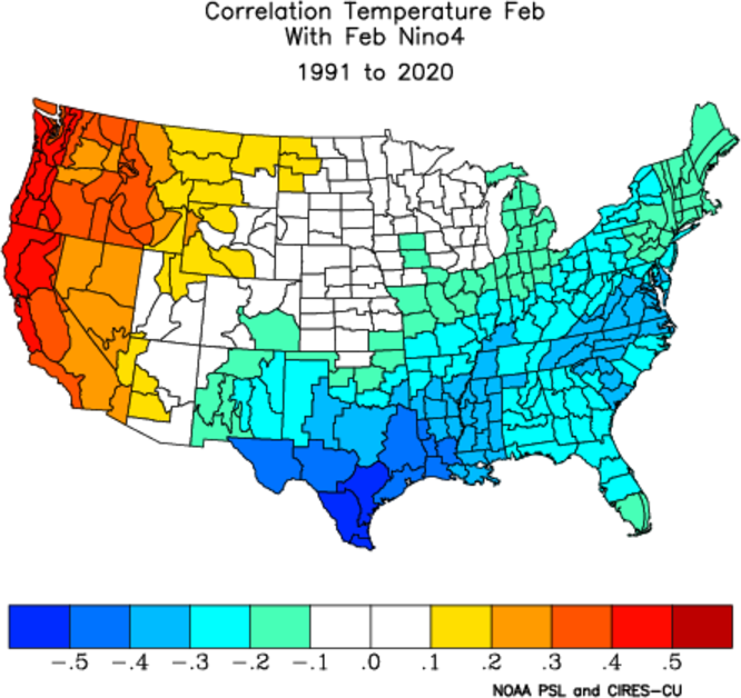
Can really see how things start to diverge in terms of position of the warmest SSTa’s after December. With Nino 1+2 warmth (east-based), Jan and Feb are also warm. With Nino 3.4, the correlation starts to break in Feb. With Nino 4 (central to west pacific), it actually correlated to a cold Feb. So while December is universally expected to be mild regardless, whether we get a backloaded winter or near wall to wall torch is based on whether the anomalies are focused on the Eastern Pacific vs Central.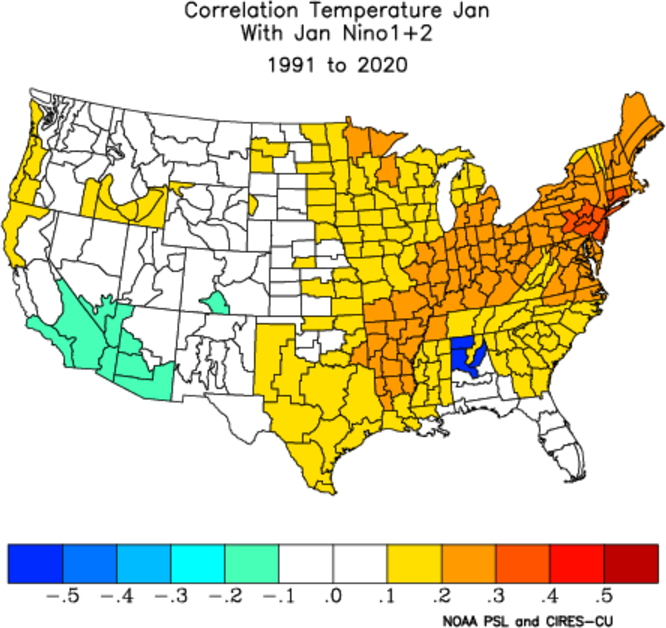
-
2026-2027 Super El Nino
LakePaste25 replied to Stormchaserchuck1's topic in Weather Forecasting and Discussion
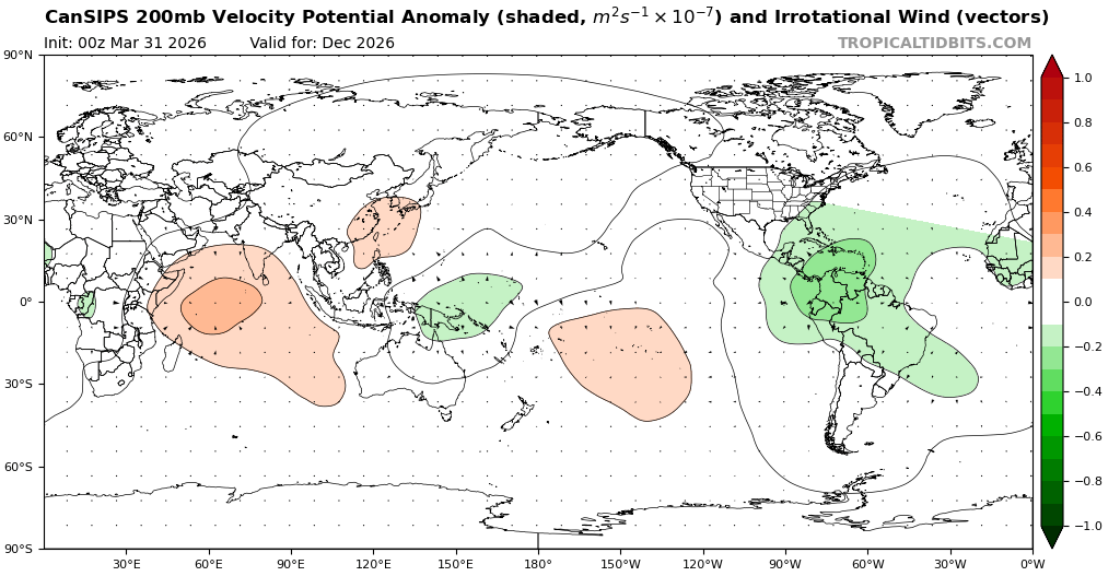
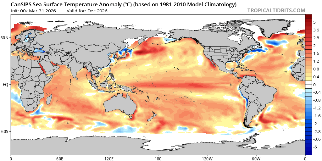
CANSIPs shows lingering nina-like convection in the maritime continent, while the CFS shows a classic nino response that slowly propagates eastward into winter.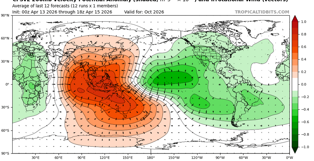
-
2026-2027 Super El Nino
LakePaste25 replied to Stormchaserchuck1's topic in Weather Forecasting and Discussion
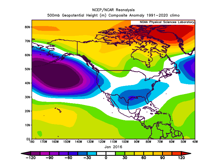
Incredible how different the Jan 2016 cold shots were vs. the Jan 2024. Jan 2024 was much more Nina-like, and probably why there wasn’t a big snowstorm in the mid atlantic or NE. They both had the roaring southern stream like you’d expect for a Nino but mismatched at 500 mb heights.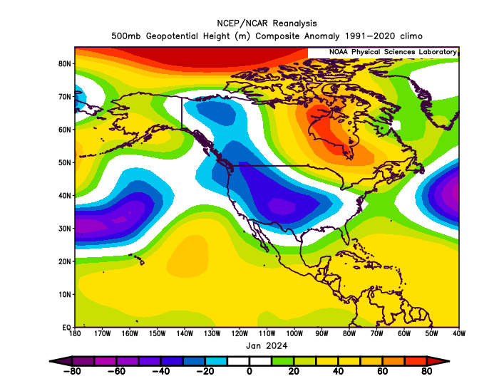
-
2026-2027 Super El Nino
LakePaste25 replied to Stormchaserchuck1's topic in Weather Forecasting and Discussion
Interesting. 1972 was one of the coolest summers on record here. -
2026-2027 Super El Nino
LakePaste25 replied to Stormchaserchuck1's topic in Weather Forecasting and Discussion
I imagine summer in the east will be on the milder, wetter, and more humid side -
2026-2027 Super El Nino
LakePaste25 replied to Stormchaserchuck1's topic in Weather Forecasting and Discussion
I see it has some split forcing showing up with some lingering convection in the west pacific. Also appears to be more basin-wide. I agree - i think a +TNH outcome like that is probably overkill even if there’s split forcing.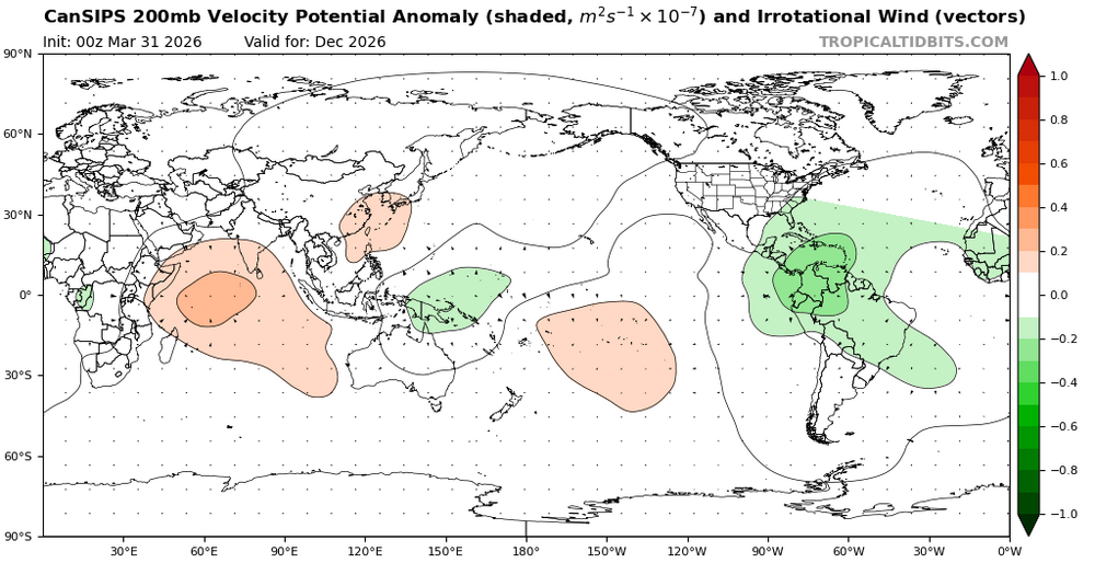

-
2026-2027 Super El Nino
LakePaste25 replied to Stormchaserchuck1's topic in Weather Forecasting and Discussion
Correct, nothing publicly available as far as I know -
2026-2027 Super El Nino
LakePaste25 replied to Stormchaserchuck1's topic in Weather Forecasting and Discussion
The new Conventional Observation Reanalysis that’s supposed to replace it only has the raw data available (https://nomads.ncep.noaa.gov/pub/data/nccf/com/core/) which is annoying since I haven’t found any custom built code that plots it yet -
2026-2027 Super El Nino
LakePaste25 replied to Stormchaserchuck1's topic in Weather Forecasting and Discussion
14-15. Models went strong or super to begin with. But that one hinged on strong WWBs in the summer and early autumn that never materialized. This one is building much earlier. -
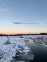
Crank up those lawnmowers
-
2026-2027 Super El Nino
LakePaste25 replied to Stormchaserchuck1's topic in Weather Forecasting and Discussion
One thing about using RONI vs. ONI is you have to be consistent. If you’re going to use RONI to say that the Nino isn’t going to be as strong, you also need to say that 24-25 and 25-26 were weak to moderate Nina’s, not neutral. -
2026-2027 Super El Nino
LakePaste25 replied to Stormchaserchuck1's topic in Weather Forecasting and Discussion
23-24 reached super criteria based off of traditional ONI, which peaked at +2.1C for NDJ. Using the new RONI however, it peaked at moderate to strong.