LakePaste25
-
Posts
1,120 -
Joined
-
Last visited
Content Type
Profiles
Blogs
Forums
American Weather
Media Demo
Store
Gallery
Everything posted by LakePaste25
-

2026-2027 Super El Nino
LakePaste25 replied to Stormchaserchuck1's topic in Weather Forecasting and Discussion
I mean aren’t mid latitude ridges expanding due to global warming regardless? The SE ridge is also getting stronger and more expansive despite La Nina’s being weaker on the absolute ONI scale…so I do not know if this is exclusive to RONI vs ONI. -
2026-2027 Super El Nino
LakePaste25 replied to Stormchaserchuck1's topic in Weather Forecasting and Discussion
There’s different uses for both. If you’re comparing the Nino 3.4 to historical rankings or you want to see how much heat is being released into the atmosphere then yes, the absolute ONI should be used. But if you’re trying to measure a sensible mid latitude response then you would use RONI. -
2026-2027 Super El Nino
LakePaste25 replied to Stormchaserchuck1's topic in Weather Forecasting and Discussion
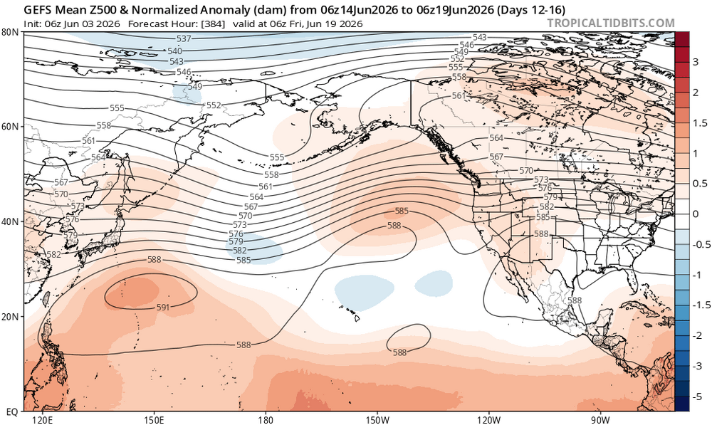
Why would I even look at what models are showing next winter with more than a grain of salt when it’s only June? I am focused on how this is developing and summer analogs. I will check on that in October. -
2026-2027 Super El Nino
LakePaste25 replied to Stormchaserchuck1's topic in Weather Forecasting and Discussion
Yeah but this shiny looking map says I’m going to have near normal temps 6 months from now in december in a record breaking super nino -
2026-2027 Super El Nino
LakePaste25 replied to Stormchaserchuck1's topic in Weather Forecasting and Discussion
I imagine most of that will be rain, but there’s always the chance for a big snow storm just like in 15-16, 82-83, etc -
2026-2027 Super El Nino
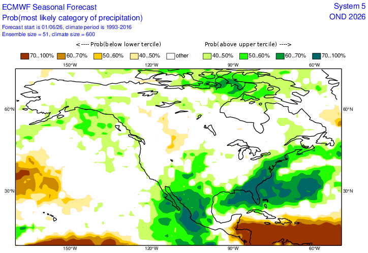
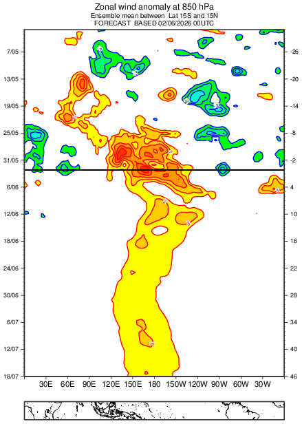
LakePaste25 replied to Stormchaserchuck1's topic in Weather Forecasting and Discussion
Looking at RONI, you can see a pretty clear and distinct El Niño and it’s only June!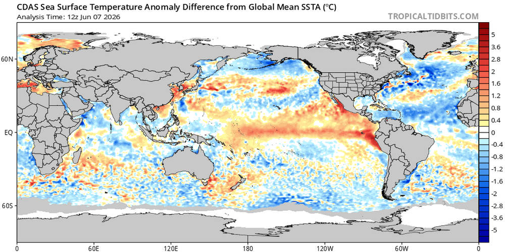
-
2026-2027 Super El Nino
LakePaste25 replied to Stormchaserchuck1's topic in Weather Forecasting and Discussion
Latest Euro seasonal gets the enhanced coastal precipitation going as early as September.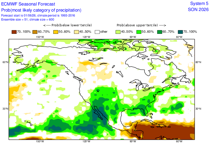
-
2026-2027 Super El Nino
LakePaste25 replied to Stormchaserchuck1's topic in Weather Forecasting and Discussion
We can probably assume that the W pac warm pool will finally slosh east if those model output verify. You don’t get a +4C ONI Nino without it doing so. -
2026-2027 Super El Nino
LakePaste25 replied to Stormchaserchuck1's topic in Weather Forecasting and Discussion
I agree, but verbatim the model run posted is not a classic +PNA/-EPO look that we tend to see in weaker Ninos. There may be periods of it, however which could be factored in the ensemble mean. I just wouldn’t take those blues in the South as “winter-like cold that supports snowfall most of the month.”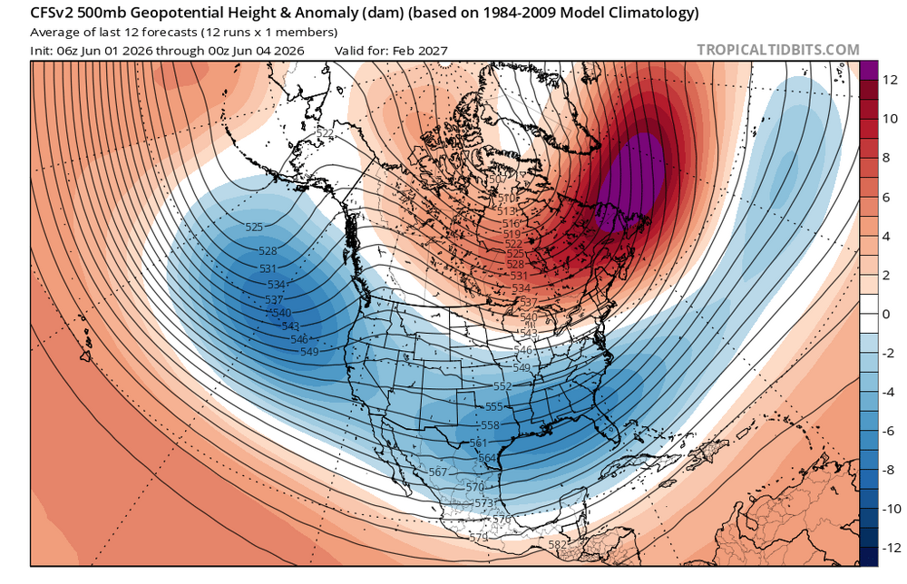
-
2026-2027 Super El Nino
LakePaste25 replied to Stormchaserchuck1's topic in Weather Forecasting and Discussion
Modelology vs meteorology. Where exactly is the cold air coming from if it’s all above normal north of Tennessee? It has to travel from somewhere on the way down right? Cold air can’t come from the pacific at California’s latitude. Which would mean at minimum, near or slightly below normal temps north of TN as it travels down? Yeah. i don’t buy wall to wall torch up here either. Maybe it’s 80/20, 70/30 or whatever. But the main reason that it’s blue in the South while dark red over the Great lakes is due to the uniformity of the airmass. 40s is well above normal for the Grest Lakes, but below normal for Louisiana.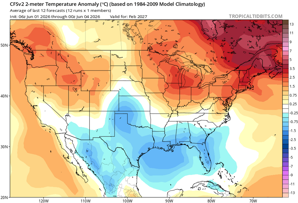
-
2026-2027 Super El Nino
LakePaste25 replied to Stormchaserchuck1's topic in Weather Forecasting and Discussion
Those blues in the South do not necessarily equate to winter-like cold that would be supportive of snow outside of the appalachians. The blues are also there because it’s very stormy with the strong extended pacific jet feeding into the active southern stream. -
2026-2027 Super El Nino
LakePaste25 replied to Stormchaserchuck1's topic in Weather Forecasting and Discussion
The issue I do have with 97-98 is a lot of these wintery stretches were so marginal with 30-35 degree days. Factor in 2-3 decades of warming and you get the idea. -
2026-2027 Super El Nino
LakePaste25 replied to Stormchaserchuck1's topic in Weather Forecasting and Discussion
Yeah I don’t expect a wall to wall pac jet extension the entire season, otherwise LAX might end up underwater. Looking at 97-98 here, there were a couple of 5-7 day wintery stretches in december, january maybe 1 week tops, and a couple more stretches in Feb and a couple more in March. Jan was the least snowiest at 9.5” while December had close to 30”. Feb/March 15-20” each. Below normal season but obviously not 0 or even top 10 lowest. -
2026-2027 Super El Nino
LakePaste25 replied to Stormchaserchuck1's topic in Weather Forecasting and Discussion
-
2026-2027 Super El Nino
LakePaste25 replied to Stormchaserchuck1's topic in Weather Forecasting and Discussion
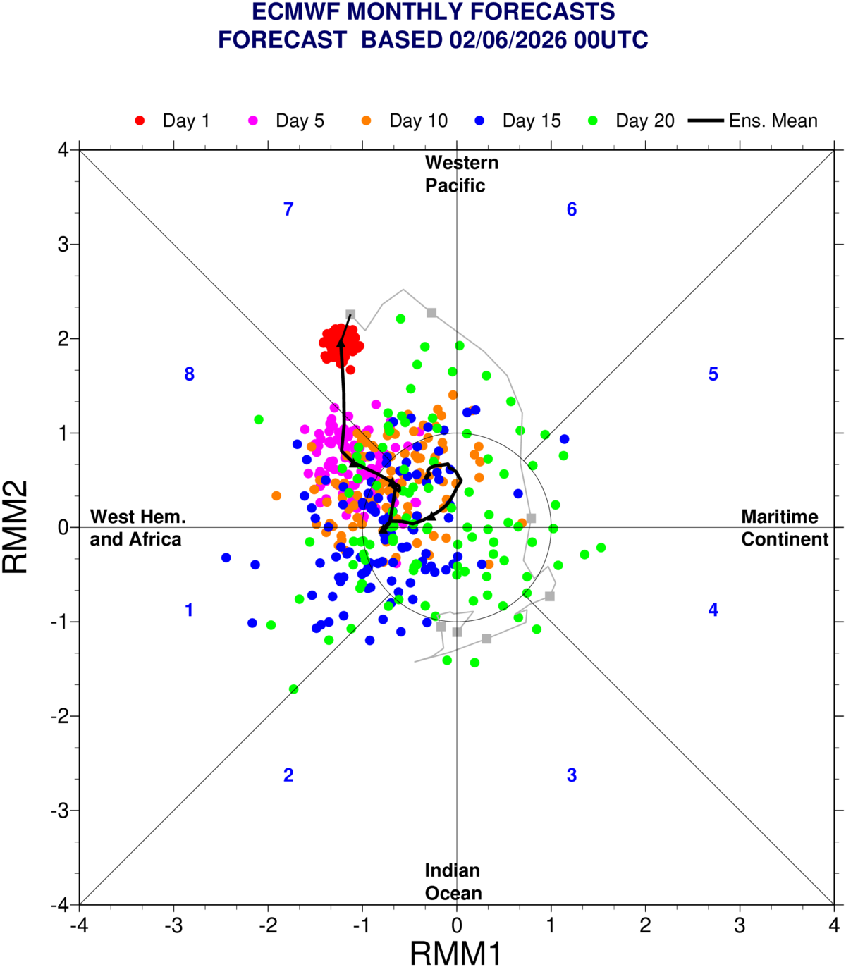
The EPS in particular seems to have a westward lean on the OLR map, which would push the RMM mean into the COD. I see less of a signal of this on the GEFS.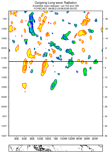

-
2026-2027 Super El Nino
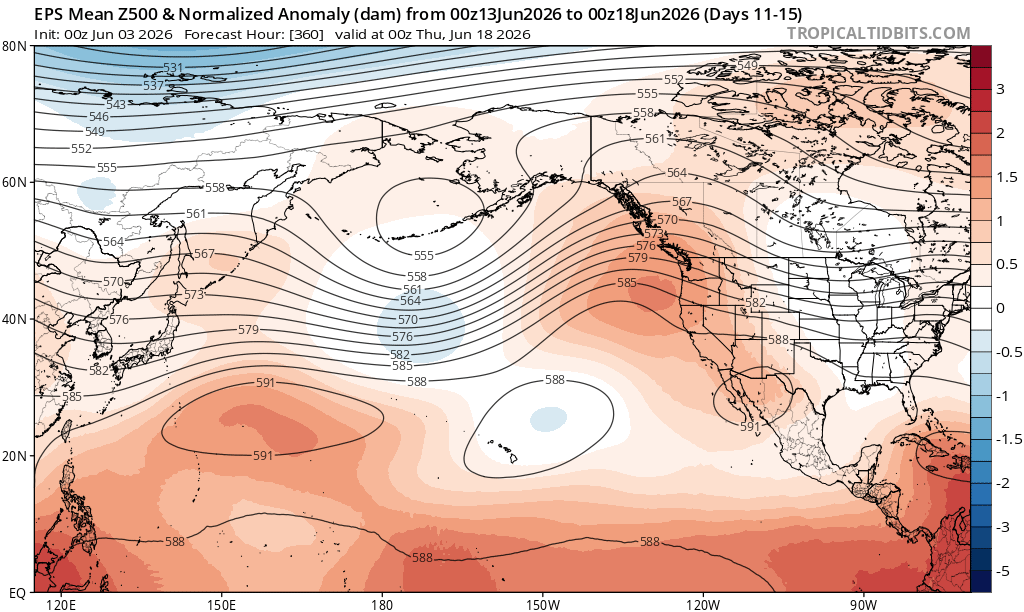
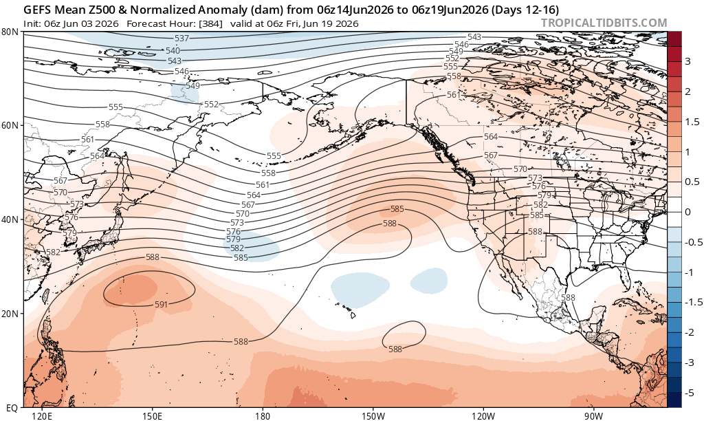
LakePaste25 replied to Stormchaserchuck1's topic in Weather Forecasting and Discussion
I think this is manifesting as a weakened mid latitude cell via destructive interference. The westward leaning convection results in downstream mid latitude trough, which then results in subsidence downstream of the trough. Where the subsidence is occurring, it competes with where we expect a mid latitude trough from Nino influenced convection over the equator. So the end result is generally a weakened aleutian low as it must compete from subsidence caused by upstream troughing. The long range GEFS starts to bring these troughs closer together, more of what we’d expect in a Nino with a broad mid latitude cell extending east of the dateline.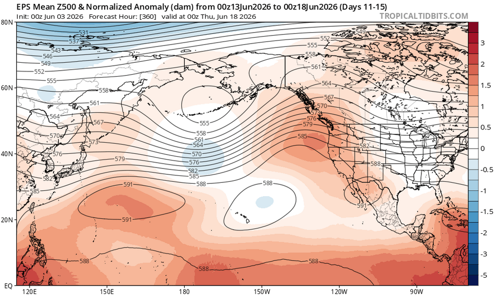
-
2026-2027 Super El Nino
LakePaste25 replied to Stormchaserchuck1's topic in Weather Forecasting and Discussion
I remember HM mentioning awhile ago that the 97-98 season came extremely close to a KU for the NE/Mid atlantic. I keep stressing that a 97-98 redux does not automatically mean “guaranteed low snow season” even for DC/PHL/NY. -
2026-2027 Super El Nino
LakePaste25 replied to Stormchaserchuck1's topic in Weather Forecasting and Discussion
My opinion is the east based nature of 97-98 did not prevent a big snowstorm from occurring. 82-83 was east based and produced a big snowstorm in the northeast and mid atlantic, and 72-73 produced a big snowstorm in the south. So whether it is east based or basin wide such as 15-16, there is still usually an opportunity or two. -
2026-2027 Super El Nino
LakePaste25 replied to Stormchaserchuck1's topic in Weather Forecasting and Discussion
Does the difference matter at that temp? 97-98 could’ve easily produced a blizzard just like 15-16. Maybe just less cold shots. -
2026-2027 Super El Nino
LakePaste25 replied to Stormchaserchuck1's topic in Weather Forecasting and Discussion
this gave me a good laugh: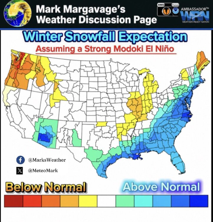
-
2026-2027 Super El Nino
LakePaste25 replied to Stormchaserchuck1's topic in Weather Forecasting and Discussion
It’s still notable that it could end up the warmest SST’s on record in that region. Maybe “strongest” is not the right word in terms of sensible atmospheric forcing. -
2026-2027 Super El Nino
LakePaste25 replied to Stormchaserchuck1's topic in Weather Forecasting and Discussion
I remember it doing pretty poorly early on before the 23-24 nino. If i remember it had a ‘09-‘10 redux with the canadian and -nao block and broad mid latitude troughing in CONUS. -
2026-2027 Super El Nino
LakePaste25 replied to Stormchaserchuck1's topic in Weather Forecasting and Discussion
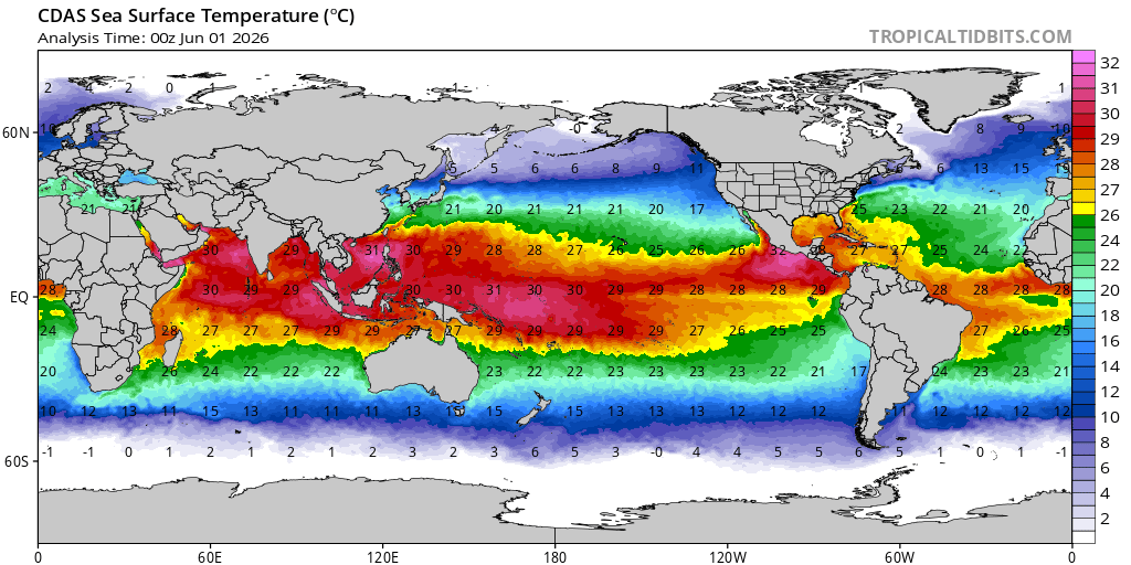
To be fair, we are also putting a major dent in the warm pool, and the warmest waters are now between 160-170E with plenty of westerlies remaining in the forecast.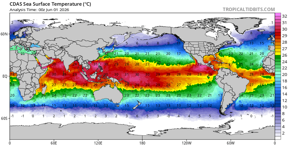
-
2026-2027 Super El Nino
LakePaste25 replied to Stormchaserchuck1's topic in Weather Forecasting and Discussion
Super Ninos aren’t always record warm for the NE unless you get that competing Nina forcing from the W pac warm pool. The typical way to get record warm temps here is via the SE ridge which ushers in subtropical air from the Gulf. Ninos don’t have this and instead typically usher in a pacific jet extension which floods the lower 48 with mild pacific air, and you have a raging southern stream bringing cool and stormy weather in the south. This pattern is usually record warm for the northern plains and Canada, but not the NE. -
can do these dumb warm vs cold wars in a banter thread? Seriously if you don’t like someone’s forecast or analysis you’re free to do your own and contribute to this thread.