LakePaste25
-
Posts
1,351 -
Joined
-
Last visited
Content Type
Profiles
Blogs
Forums
American Weather
Media Demo
Store
Gallery
Everything posted by LakePaste25
-

2026-2027 Record-breaking El Nino
LakePaste25 replied to Stormchaserchuck1's topic in Weather Forecasting and Discussion
The wave started near the Arabian Sea and has been slowly moving east into the MC. It has been destructively interfered with by the Nino and is only able to contribute when it reached the MC because the +AAM temporarily relaxed. Would the west pacific waters in 1997, 1982, 1972 have been cool enough at this point in the summer to stop this forcing? I disagree. -
2026-2027 Record-breaking El Nino
LakePaste25 replied to Stormchaserchuck1's topic in Weather Forecasting and Discussion
Where are you seeing an EWB? Do you have any charts showing it? -
2026-2027 Record-breaking El Nino
LakePaste25 replied to Stormchaserchuck1's topic in Weather Forecasting and Discussion
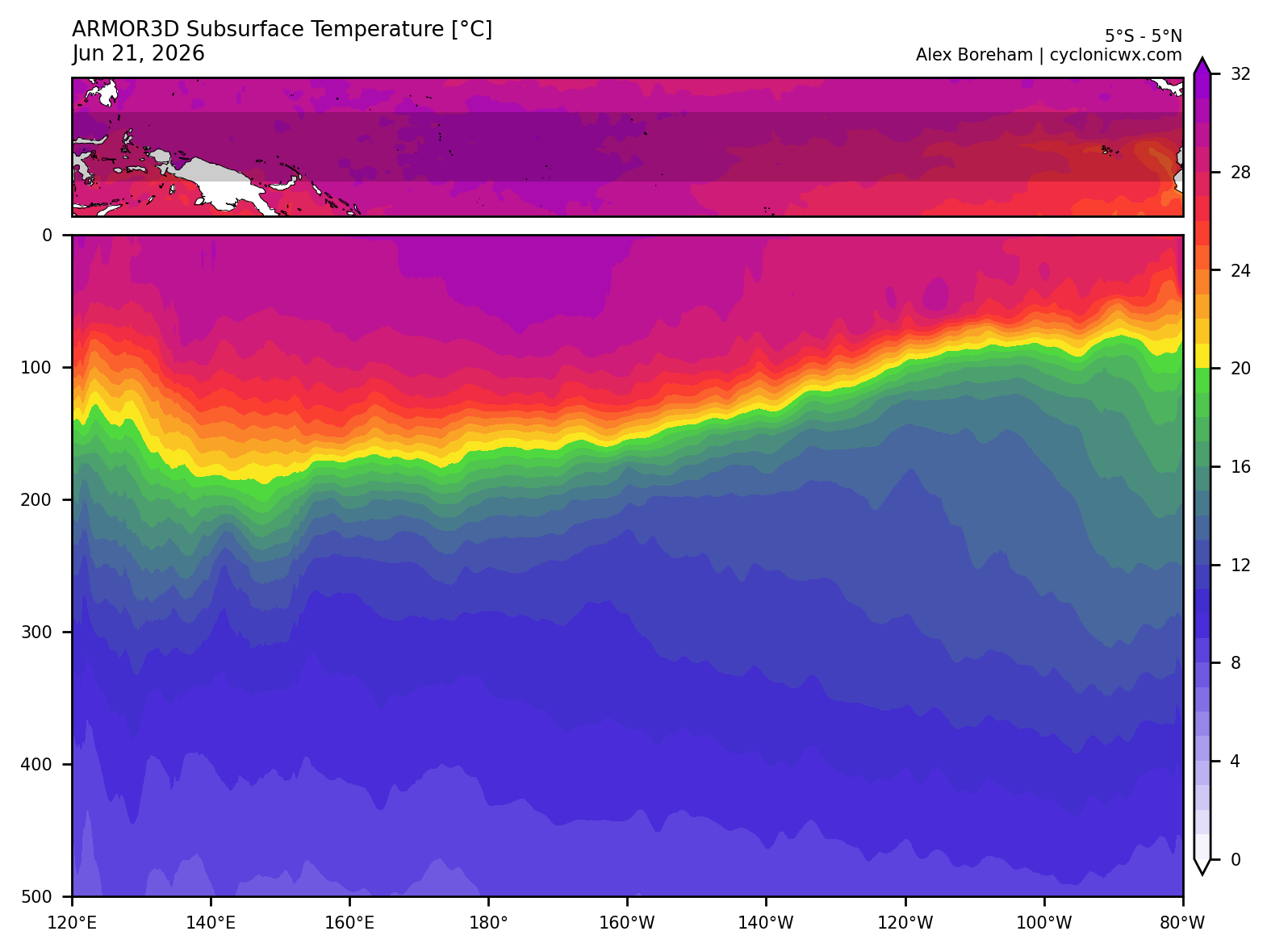
One key characteristic of an east based event is the thermocline has an even or even slightly downward slope from W to E which is what tends to shut down MC convection. Still sloping the other way although you can see may have turned the corner out near 120E. We will see if this propagates across or not. Even if this is east based, I am going to say the same thing which is mostly above normal winter with windows of opportunity for a KU event.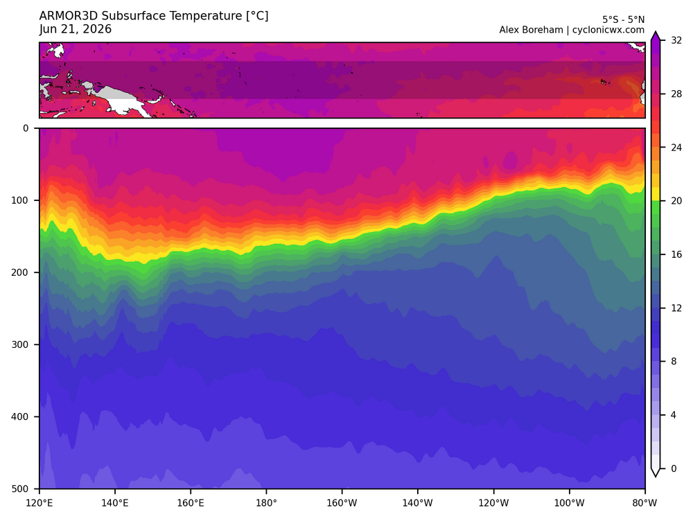
-
2026-2027 Record-breaking El Nino
LakePaste25 replied to Stormchaserchuck1's topic in Weather Forecasting and Discussion
That’s a good question. A warmer atmosphere can hold more water vapor (exponentially) but i’d think it also takes more to actually wring it out. The warmer SSTs certainly help with that. Intuitively i think the “magic number” would have to go up as it warms. -
2026-2027 Record-breaking El Nino
LakePaste25 replied to Stormchaserchuck1's topic in Weather Forecasting and Discussion
This is all true but in theory, if you get much warmer SSTs to the east, it can generate conditions suppress convection to the west regardless if the SSTs to the west are “warm enough” for convection. It likely just takes stronger +ENSO conditions than before to achieve. I’m increasingly convinced we will actually achieve this (suppressed MC) with this event. -
2026-2027 Record-breaking El Nino
LakePaste25 replied to Stormchaserchuck1's topic in Weather Forecasting and Discussion
-
2026-2027 Record-breaking El Nino
LakePaste25 replied to Stormchaserchuck1's topic in Weather Forecasting and Discussion
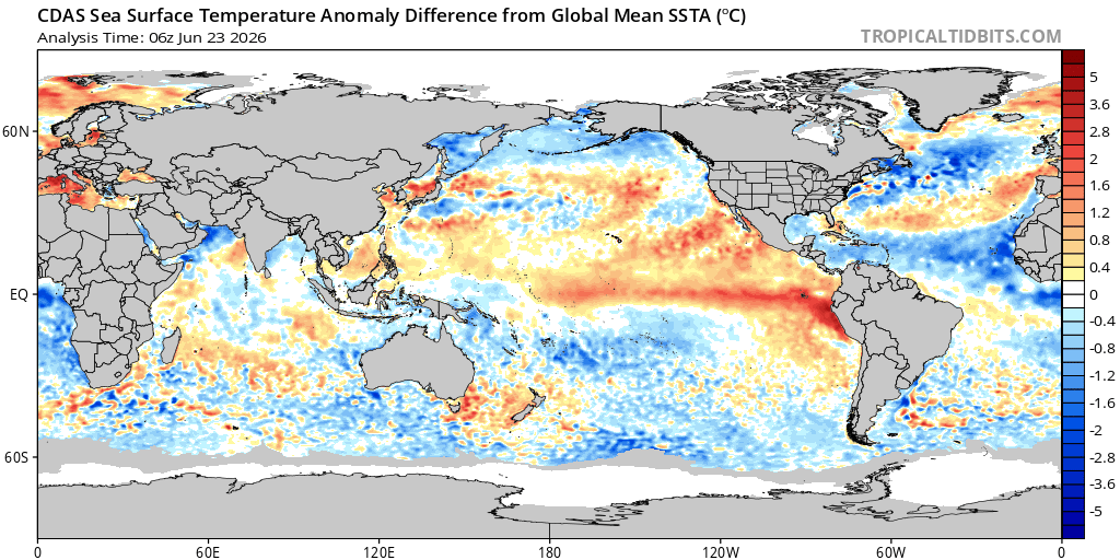
I do think RONI matters here when you’re looking at how the W pacific SSTS can destructively interfere with things. Mostly because warm SSTAs everywhere also raise the “floor” of 500 mb GPH, so a negative relative anomaly in the W pac is probably sufficient in preventing the W pac from contributing to a rossby wave response (floor is high enough it’s not a ridge relative to GPH). Hope I’m making any sense when I theorize this. tldr: W pac is already becoming negative in relative terms which i think is “good enough” since height anomalies are also relative in terms of rossby waves.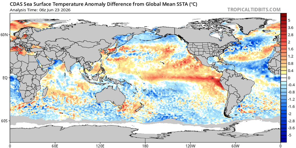
-
2026-2027 Record-breaking El Nino
LakePaste25 replied to Stormchaserchuck1's topic in Weather Forecasting and Discussion
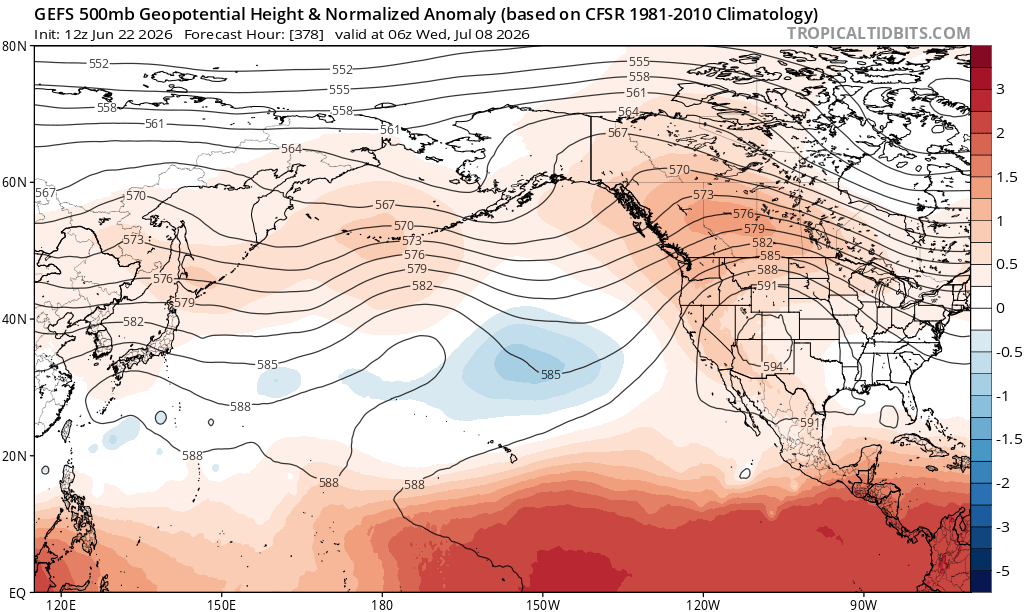
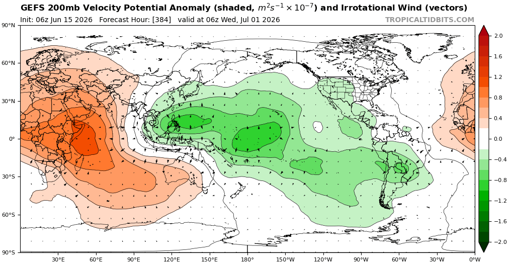
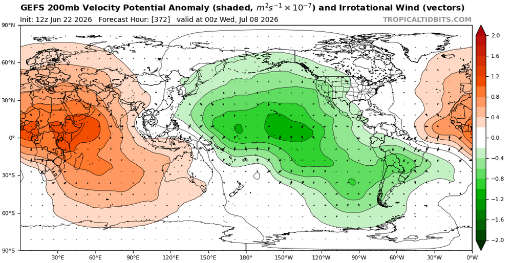
Healthy +ENSO coupled mid-latitude cell showing up in the central pacific on the GEFS. W pac forcing starting to diminish.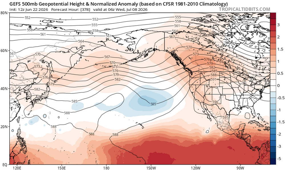
-
2026-2027 Record-breaking El Nino
LakePaste25 replied to Stormchaserchuck1's topic in Weather Forecasting and Discussion
it’s why i always laugh when I see agencies such as AccuWeather or twitter accounts deterministically forecast seasonal snow totals in ENSO years like this. Above normal temps in the northeast and great lakes that fade towards neutral as you go south is a sure bet, but nobody can predict whether places like DCA will get a single storm that produces 150% of their seasonal totals. -
2026-2027 Record-breaking El Nino
LakePaste25 replied to Stormchaserchuck1's topic in Weather Forecasting and Discussion
This morning it was in the 50s and was raining. Much more typical of what I’d expect for a pre-super Nino summer around here as 1972, 1982, and 1997 had a handful of these days in June and July. -
2026-2027 Record-breaking El Nino
LakePaste25 replied to Stormchaserchuck1's topic in Weather Forecasting and Discussion
It goes both ways. When some of us throw 97-98 into the mix, we aren’t saying the snow totals will repeat verbatim. Some of this is just random variability. 97-98 came extremely close to a producing KU’s a couple of times and could actually produce one if the general pattern repeated. So people shouldn’t freak out that their snow is being taken away when that year is mentioned. -
2026-2027 Record-breaking El Nino
LakePaste25 replied to Stormchaserchuck1's topic in Weather Forecasting and Discussion
What are the top analogs for this event? Let me guess: 09-10, 14-15, 04-05, 02-03, 76-77, and 77-78 -
2026-2027 Record-breaking El Nino
LakePaste25 replied to Stormchaserchuck1's topic in Weather Forecasting and Discussion
Not that unusual in super Nino events. I wouldn’t expect 24/7 +AAM and it’ll probably bounce back quickly. -
2026-2027 Record-breaking El Nino
LakePaste25 replied to Stormchaserchuck1's topic in Weather Forecasting and Discussion
I know @bluewave brings this up a lot, but I will forever be fascinated by the clean phase 8 pass through in January 2022. With all of the competing Nina forcing going on, I don’t know how we pulled that off especially during an actual Nina. -
2026-2027 Record-breaking El Nino
LakePaste25 replied to Stormchaserchuck1's topic in Weather Forecasting and Discussion
I consider 2021-2022 to be an east-based La Niña.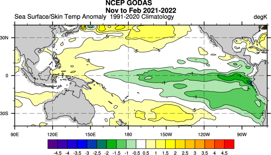
-
2026-2027 Record-breaking El Nino
LakePaste25 replied to Stormchaserchuck1's topic in Weather Forecasting and Discussion
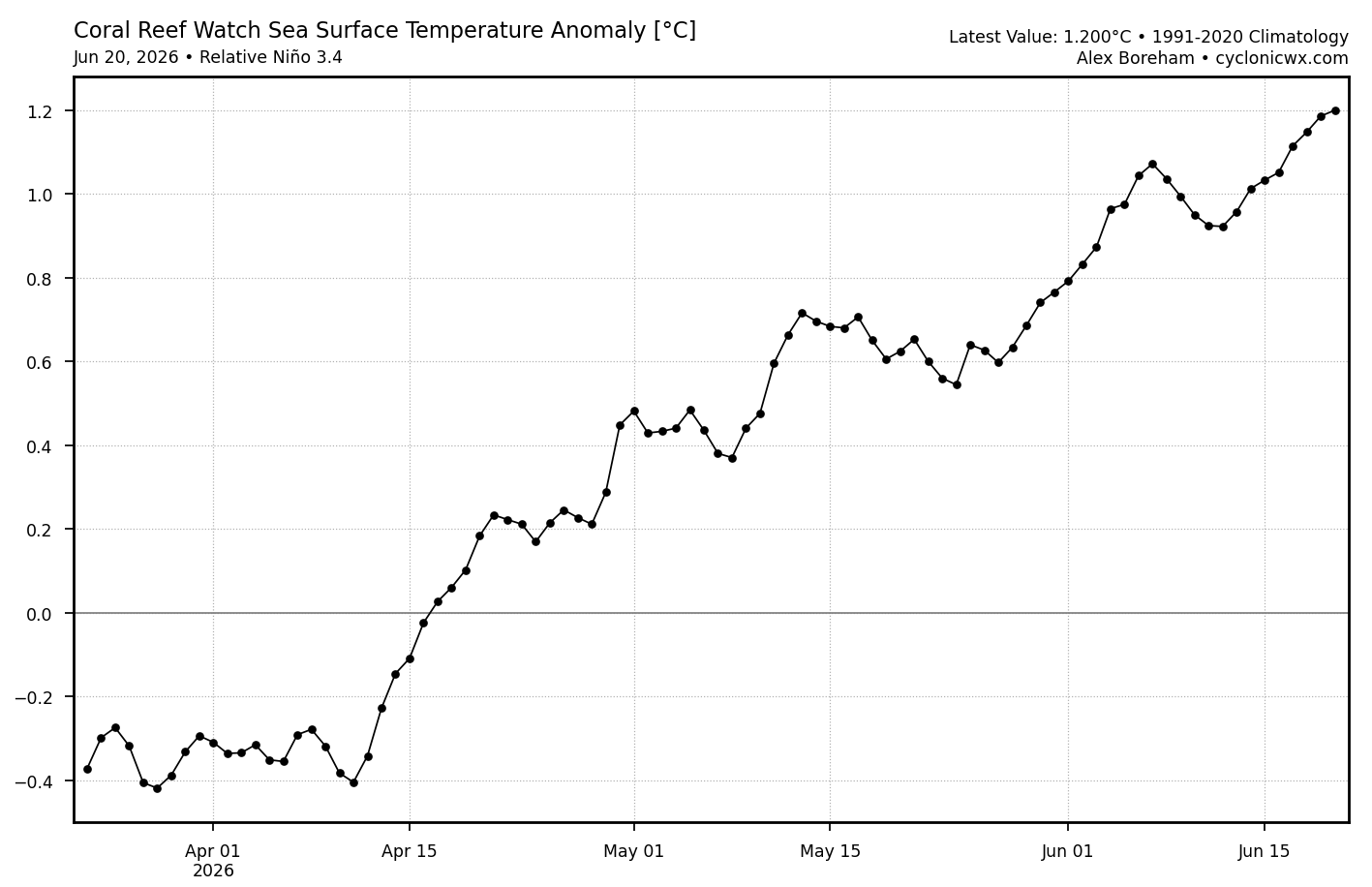
CRW is already at +1.2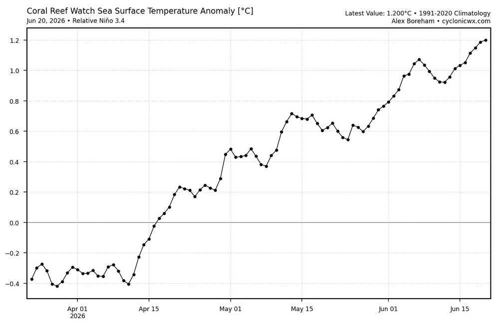
-
2026-2027 Record-breaking El Nino
LakePaste25 replied to Stormchaserchuck1's topic in Weather Forecasting and Discussion
PV aside, if we can shift that warm pool east it’ll allow for some brief periods of -EPO/+TNH during jet retractions. We missed out on that during ‘23-‘24 because W pac forcing instantly reverted us to the canonical Aleutian ridge La Niña pattern whenever the jet retracted. -
2026-2027 Record-breaking El Nino
LakePaste25 replied to Stormchaserchuck1's topic in Weather Forecasting and Discussion
-
2026-2027 Record-breaking El Nino
LakePaste25 replied to Stormchaserchuck1's topic in Weather Forecasting and Discussion
So far this is preventing us from having a cooler summer. The summers of 1997, 1982, 1972 were well below normal here. We will see if this competing forcing will continue into the fall. -
super el nino banter thread
LakePaste25 replied to forkyfork's topic in Weather Forecasting and Discussion
why is snowman 5 posted? i dont see how busted warm calls are any different than metfan’s busted april snow maps. Are people that sensitive they can’t handle someone making warm forecasts? -
2026-2027 Record-breaking El Nino
LakePaste25 replied to Stormchaserchuck1's topic in Weather Forecasting and Discussion
More like I want the W pac warm pool to completely shift east so we can have better synoptic snow the following winters. A mid +2c super nino that probably ends up with a warm winter anyway won’t do the job. Might as well go for the full historic, make this the sacrificial lamb and see if we can get good patterns the years after -
2026-2027 Record-breaking El Nino
LakePaste25 replied to Stormchaserchuck1's topic in Weather Forecasting and Discussion
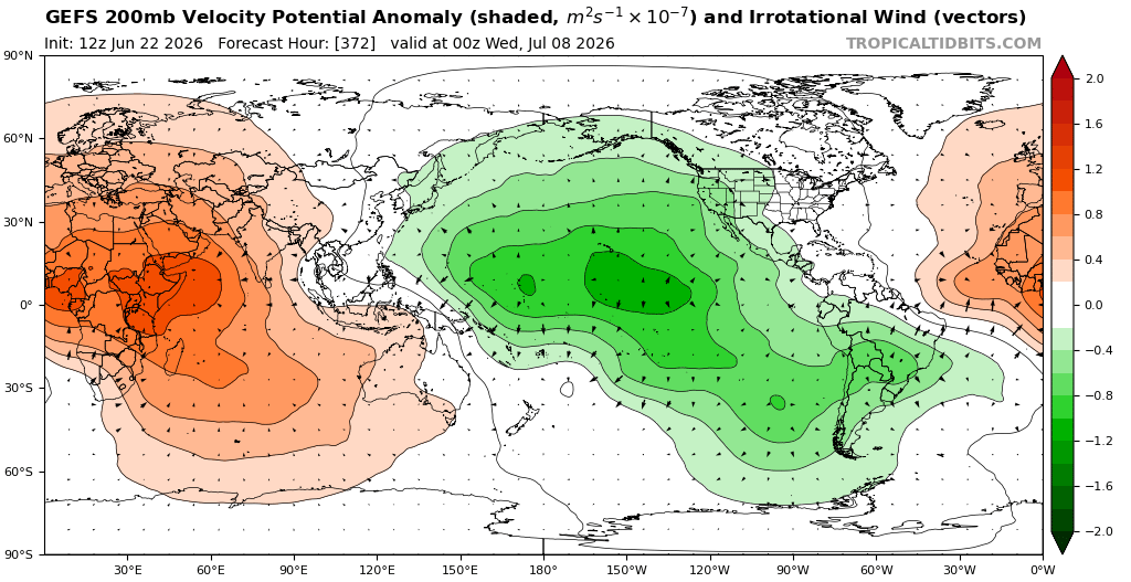
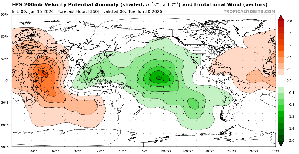
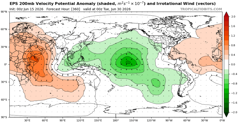
Ensembles really want to hang onto this W pac forcing too. Competing Nina influence for the foreseeable future.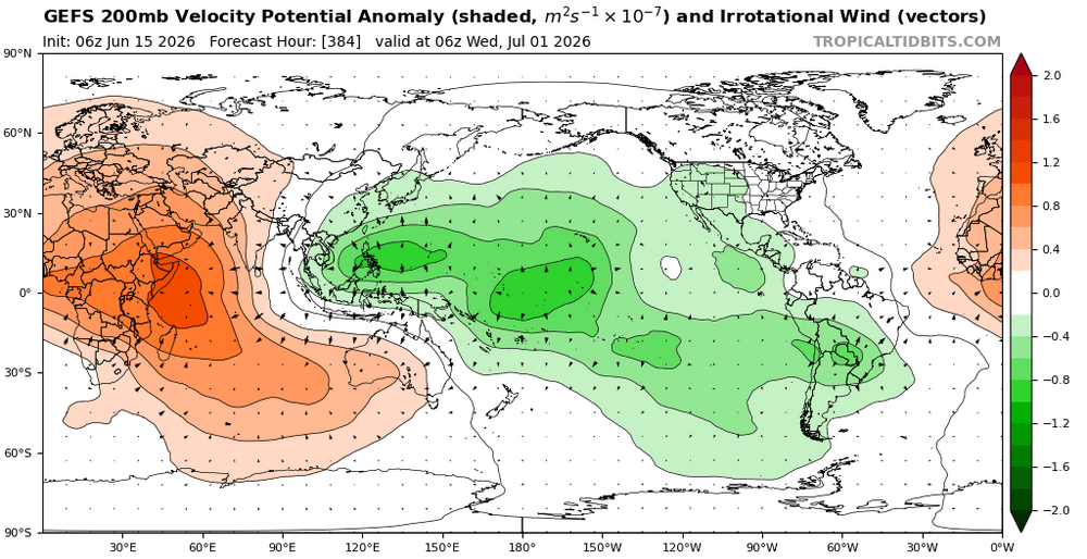
-
super el nino banter thread
LakePaste25 replied to forkyfork's topic in Weather Forecasting and Discussion
Hopefully CAD doesn’t ruin the Christmas torch. If its going to be mild or warm, I want BBQ and pool weather -
super el nino banter thread
LakePaste25 replied to forkyfork's topic in Weather Forecasting and Discussion
Good money if you can get it -
super el nino banter thread
LakePaste25 replied to forkyfork's topic in Weather Forecasting and Discussion
Can’t wait for the UAH spike. going to be a rough year for the deniers.