
LakePaste25
-
Posts
1,351 -
Joined
-
Last visited
Content Type
Profiles
Blogs
Forums
American Weather
Media Demo
Store
Gallery
Everything posted by LakePaste25
-

2026-2027 Record-breaking El Nino
LakePaste25 replied to Stormchaserchuck1's topic in Weather Forecasting and Discussion
Definitely true for temperature records too. There’s no possible way that Phoenixville, PA hit 111 in the early 1900s. Many of these should be tossed IMO. -
2026-2027 Record-breaking El Nino
LakePaste25 replied to Stormchaserchuck1's topic in Weather Forecasting and Discussion
During super ninos, the most favored Great Lakes areas are those that favor NW flow lake effect, e.g. Edinboro/Colt Station/Chautaqua Ridge/S Tug Hill/Syracuse. This is due to the sheer number of coastal storms and even if they are mostly rain, the N stream diving in after can result in NW flow lake enhanced/upslope snow. -
2026-2027 Record-breaking El Nino
LakePaste25 replied to Stormchaserchuck1's topic in Weather Forecasting and Discussion
i’m aware. It was a jab at people who downplay heatwaves when they say “it’s called summer, it’s supposed to be hot.” -
2026-2027 Record-breaking El Nino
LakePaste25 replied to Stormchaserchuck1's topic in Weather Forecasting and Discussion
i just thought the cold last winter was overhyped. It’s called winter it’s supposed to be cold. -
2026-2027 Record-breaking El Nino
LakePaste25 replied to Stormchaserchuck1's topic in Weather Forecasting and Discussion
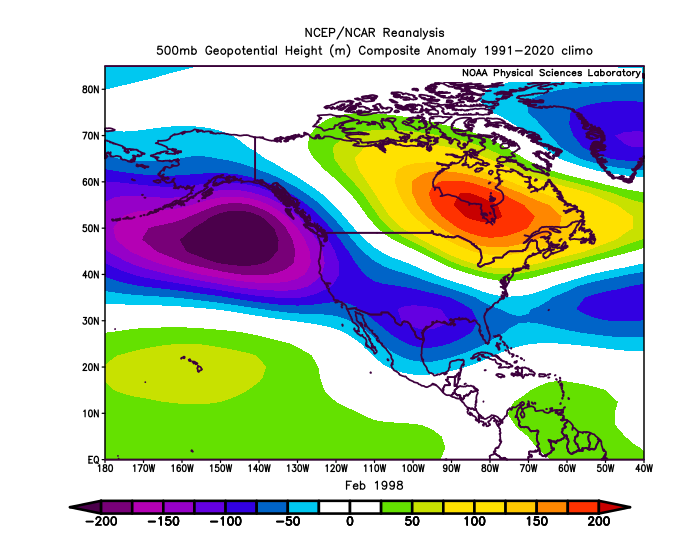
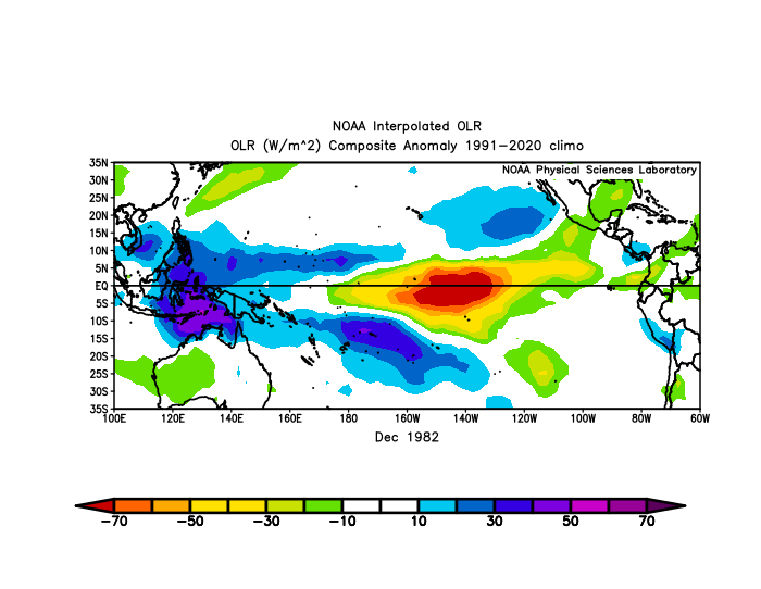
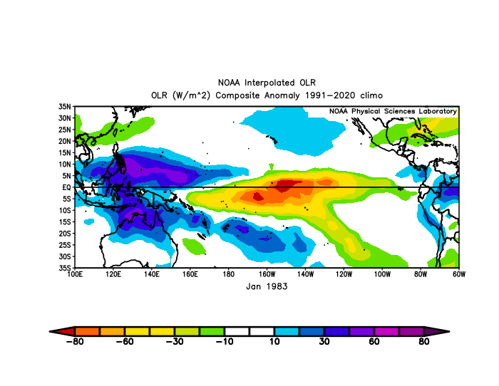
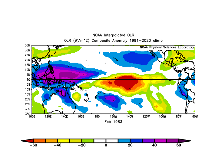
Very subtle but you can see how more dateline forcing shifts the Aleutian Low away from the PNA domain and more equatorward in 1983. Keep in mind it was a colder climate period despite showing a *weaker* low. Obviously the -NAO is a major help here.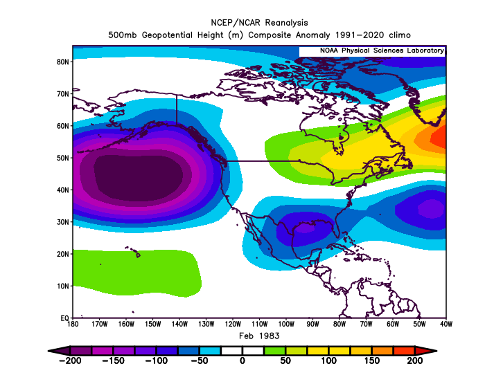
-
2026-2027 Record-breaking El Nino
LakePaste25 replied to Stormchaserchuck1's topic in Weather Forecasting and Discussion
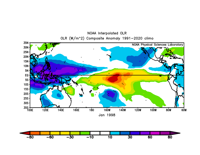
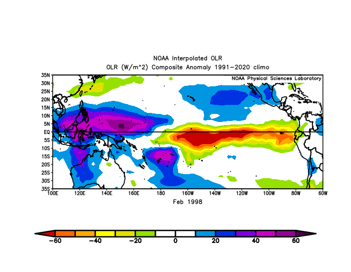
The forcing was similar but Feb 1983 was more confined to the dateline vs the EPac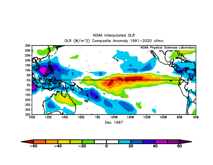
-
2026-2027 Record-breaking El Nino
LakePaste25 replied to Stormchaserchuck1's topic in Weather Forecasting and Discussion
Much of this depends on how much ocean heat is lost from the El Niño convection that’s occurring. In theory we run out of warm water to sustain El Niño in such conditions. It has to come from somewhere. -
2026-2027 Record-breaking El Nino
LakePaste25 replied to Stormchaserchuck1's topic in Weather Forecasting and Discussion
-
2026-2027 Record-breaking El Nino
LakePaste25 replied to Stormchaserchuck1's topic in Weather Forecasting and Discussion
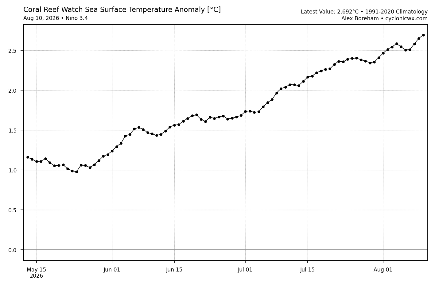
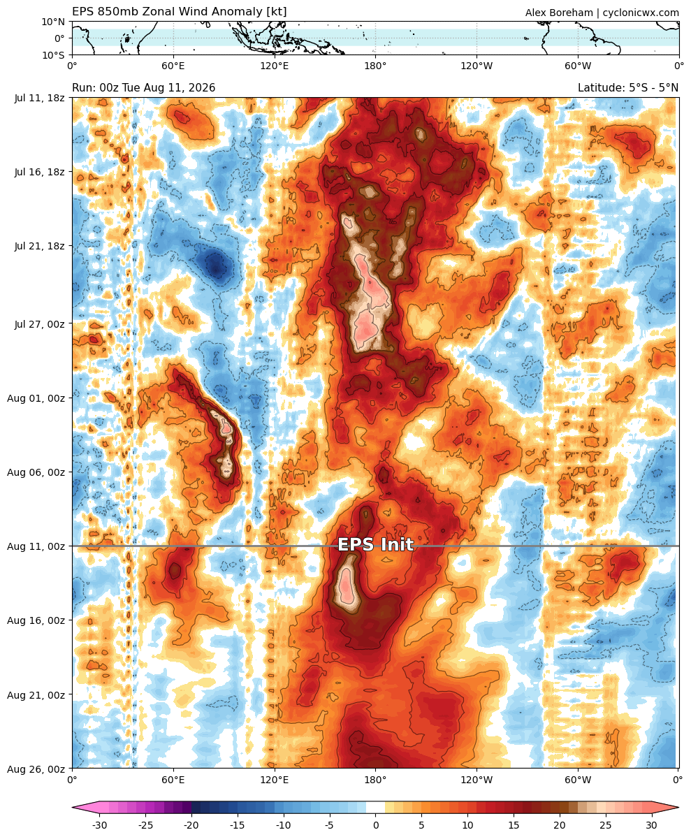
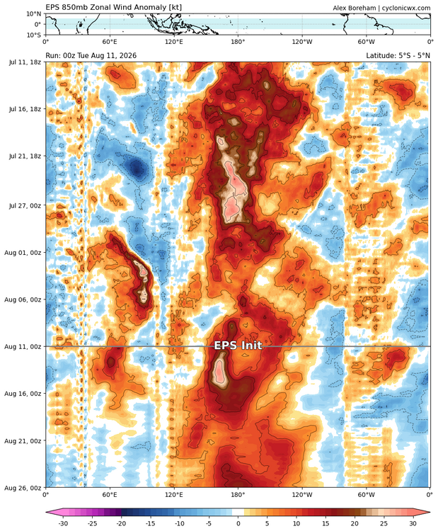
Time to dust off the key and open back up to OT? anyways, we are getting to about +2.7 WWBs will keep this going up through the end of the month.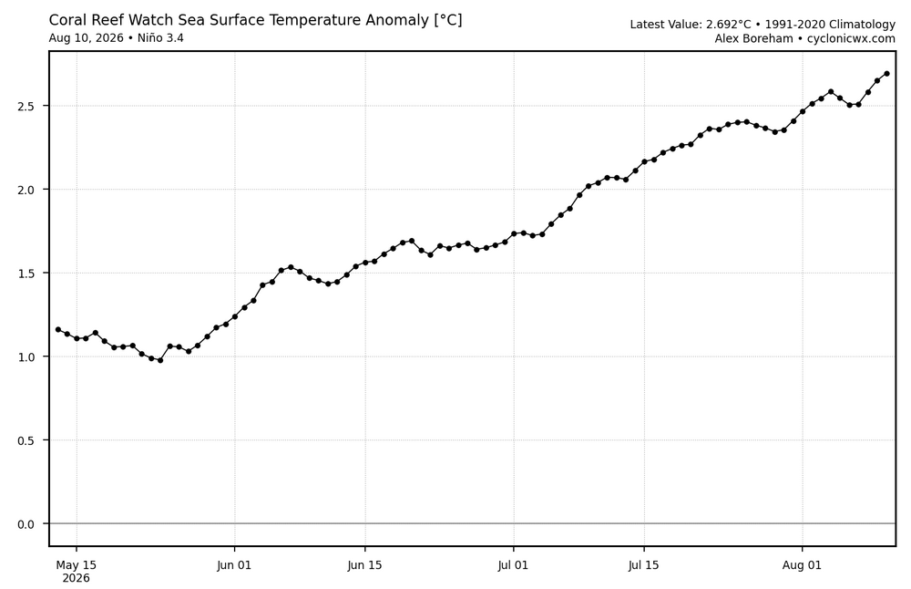
-
2026-2027 Record-breaking El Nino
LakePaste25 replied to Stormchaserchuck1's topic in Weather Forecasting and Discussion
I’ve been stressing that here nonstop (along with a few others) and even snowman agreed with me to some extent. If people are getting triggered over that, it’s mostly happening outside of this thread. -
2026-2027 Record-breaking El Nino
LakePaste25 replied to Stormchaserchuck1's topic in Weather Forecasting and Discussion
yeah he said he would delete his account. I reached out as a gesture and the message is still unread from last week. -
2026-2027 Record-breaking El Nino
LakePaste25 replied to Stormchaserchuck1's topic in Weather Forecasting and Discussion
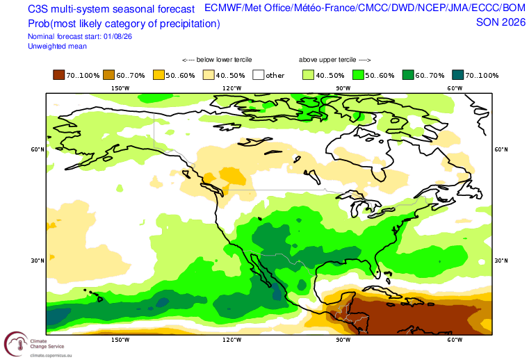
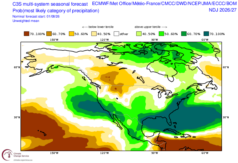
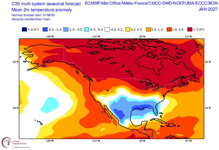
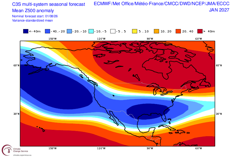
All things considered, the C3S isn’t terrible. It also tends to be one of the more correct seasonal blends that doesn’t overestimate the cold too much.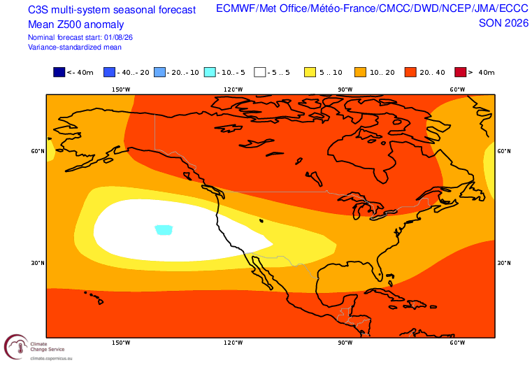

-
2026-2027 Record-breaking El Nino
LakePaste25 replied to Stormchaserchuck1's topic in Weather Forecasting and Discussion
I don’t believe it. I think there could be some opportunities but otherwise it’s way overdone. -
2026-2027 Record-breaking El Nino
LakePaste25 replied to Stormchaserchuck1's topic in Weather Forecasting and Discussion
Is it not reasonable to go warm in the GL/NE for a super Nino? That’s common knowledge. It will be above normal in the mean. Sure we can discuss how it might not be an all out torch (and I think it can be prevented given that we might shut down MC convection), but above normal is an easy call. -
2026-2027 Record-breaking El Nino
LakePaste25 replied to Stormchaserchuck1's topic in Weather Forecasting and Discussion
Yeah other than that 2 week stretch in late January/early February the cold wasn’t really that impressive. Same with 2024-25. Just normal cold that we used to get much more frequently. The snow was decent though. -
2026-2027 Record-breaking El Nino
LakePaste25 replied to Stormchaserchuck1's topic in Weather Forecasting and Discussion
I know NMME has an amplitude bias with ENSO but still…even if it were a half a degree cooler, that is still crazy. -
2026-2027 Record-breaking El Nino
LakePaste25 replied to Stormchaserchuck1's topic in Weather Forecasting and Discussion
agreed. We can only predict the aspects of El Niño that I like (such as the strong STJ), not the things I don’t like (the warmth). The warmth we will just have to wait and see. -
2026-2027 Record-breaking El Nino
LakePaste25 replied to Stormchaserchuck1's topic in Weather Forecasting and Discussion
Latest NMME mean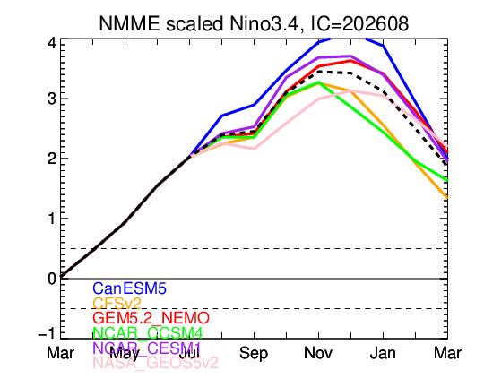
-
2026-2027 Record-breaking El Nino
LakePaste25 replied to Stormchaserchuck1's topic in Weather Forecasting and Discussion
I would expect lingering Nino 1+2 warmth well into next spring and summer. If I remember correctly, when 1+2 fails to cool down like that we usually get a weaker Nina rebound or just stay cold neutral. Would have to look more into the data. -
2026-2027 Record-breaking El Nino
LakePaste25 replied to Stormchaserchuck1's topic in Weather Forecasting and Discussion
Is there anything at this point between now and October that could stop this from becoming the Wilma of El Nino events? Seems like it’s becoming so well coupled in the tropics that that there really isn’t. -
super el nino banter thread
LakePaste25 replied to forkyfork's topic in Weather Forecasting and Discussion
snowman got too worked up over these people and let them get to him. It’s more fun to talk about warm anomalies and trigger them. Gotta roll with it. And the cool thing about it is we get brand new maps with red everywhere every other month, so I am constantly supplied with new material. -
2026-2027 Record-breaking El Nino
LakePaste25 replied to Stormchaserchuck1's topic in Weather Forecasting and Discussion
I’m actually not dismissing them anymore. I dismissed the CANSIPs early on because it derived the colder look from Modoki SSTAs in the tropical pacific, and Modoki isn’t happening so I tossed it. But the Euro looks better now *despite being even stronger and more east based*, so now we have to wonder if the a strongly suppressed cell over the W Pacific (due to extreme E based nature) will help. It makes sense to me in theory. -
2026-2027 Record-breaking El Nino
LakePaste25 replied to Stormchaserchuck1's topic in Weather Forecasting and Discussion
I can also see that it went warmer in Alaska/PNW. So, whenever the jet does retract, it could be modeling periods of -EPO/+TNH rather than an MC forcing induced Aleutian ridge. Notice that 850 Aleutian low actually got colder/stronger, not weaker as well. So it could just be forecasting more “all flavors of ENSO” rather than “La Niña like interferences.” -
2026-2027 Record-breaking El Nino
LakePaste25 replied to Stormchaserchuck1's topic in Weather Forecasting and Discussion
I don’t deny that it could verify warmer than what the Euro is showing. The Aleutian Low/SE trough are not as cold in those areas as pre-2000s Ninos, I get it. The point I’m making is due to the fact that it’s record breaking, the odds of seeing a Jan 2024 type pattern (arctic cold dumping from the NW US, a parade of Great Lakes cutters) and Dec 2015 (more cutters) are lower, because if any Nino event is going to shut down the forcing that caused these to happen, it will be this one. -
2026-2027 Record-breaking El Nino
LakePaste25 replied to Stormchaserchuck1's topic in Weather Forecasting and Discussion
Makes sense to me. A stronger Nino would theoretically result in a stronger correlation to the canonical pattern that goes with it. That 23-24 map looks like it was showing warmer in both the W and SE compared to now which makes sense.