
Stx_Thunder
-
Posts
409 -
Joined
Content Type
Profiles
Blogs
Forums
American Weather
Media Demo
Store
Gallery
Everything posted by Stx_Thunder
-

Texas 2024 Discussion/Observations
Stx_Thunder replied to Stx_Thunder's topic in Central/Western States
Getting more robust and sustained cluster development just northwest of San Antonio with a new severe warning there and new development ongoing now further southwest. All activity in the region is still progressing south fairly slow also since cells initiated about 3 hours ago now. -
Texas 2024 Discussion/Observations
Stx_Thunder replied to Stx_Thunder's topic in Central/Western States
Clearly seeing the robust ML Low spinning even on radar over NM (south of Albuquerque) and still edging south over the past several hours. Also seeing a few lightning strikes starting to show up now in the light precip shield around the center near Albuquerque. Del Rio 12z UA obs earlier this morning already has around 60 knots effective shear and WBZ height now under 10 kft. Fairly stout and typical, but definitely not un-breakable 850mb inversion. Especially with all the dynamics and front coming in later today or this evening. Definitely going to be interesting tonight even over the southern half and San Antonio area in the more robust thunder initiation zone. -
Texas 2024 Discussion/Observations
Stx_Thunder replied to Stx_Thunder's topic in Central/Western States
Still looks, and getting even more and more convectively interesting now (severe potential also) with each new Euro and GFS run, tomorrow night - Tuesday morning for pretty much all the eastern half. Even San Antonio area, and into deep STX. 'Not surprised at all SPC hasn't even pushed the marginal risk area on D2 outlook update earlier today over STX (typical of them). Incoming ML trough/H5 Low out west keeps trending further south in the state, speeding up the arrival of 40+ kt DL shear now and better dynamics toward the lower coast also (more in line now with the incoming frontal convective activity Monday night). CIN is already fairly weak on this evening 0Z soundings (noticing that down here today with bigger cumulus formation and storms last Friday morning that I didn't expect), and projected to rapidly erode tomorrow evening (if any by then). Bulk shear already around 50 knots and 40 at H5 on 0Z Del Rio sounding this evening. Moisture will likely be enough. Only thing possibly sig lacking is good enough ML lapse rates that are projected to lower as Monday night progresses.. Later this week into next week could also get interesting with trends. -
Texas 2024 Discussion/Observations
Stx_Thunder replied to Stx_Thunder's topic in Central/Western States
Both GFS and Euro starting to show a potentially robust cutoff H5 Low out west over Baja/W Mex around Nov 5. If that's the case, then we could have a more prolonged wet period over the state to start November (and possible severe). Ensembles have been outputting some fairly signficant rain amounts in early November for about a week now. Latest ECMWF run going up to 4 in. over the northern half. Given that LN still hasn't developed even officially into a weak state (like CPC insisted earlier this year, by August/September), the odds are decent for at least some actual rainfall over much of the state. And dynamical ENSO models now aren't showing much of any LN developing this winter. Which would be better overall for TX. -
Texas 2024 Discussion/Observations
Stx_Thunder replied to Stx_Thunder's topic in Central/Western States
Some decent convective cluster action starting to get going on the mid-coast now ahead of that front that’s to bring some fairly comfortable conditions across the state the next few days (definitely fall-like all things considered just coming out of summer & still September). Nothing powerful though so far on lightning strike analysis. The drier frontal airmass could get sustenance for several days with the northerly flow on the outer western circulation of hurricane Helene as it goes inland and north into the mid-south. - - - - - WBZ height is pretty low for the time of year on BRO and CRP soundings today. Right near 10,000’ now on special 18Z obs on CRP with a bit of a dry slot 700mb - 500mb layer which may enhance the severe wind gust and hail potential a little bit in the strongest cells earlier this evening over STX. SPC surprisingly has marginal risk area even down the lower coast on current D1 outlook through early tomorrow (despite the still quite meager shear values). -
Texas 2024 Discussion/Observations
Stx_Thunder replied to Stx_Thunder's topic in Central/Western States
https://www.wpc.ncep.noaa.gov/metwatch/metwatch_mpd_multi.php?md=0968&yr=2024 WPC now has a quite broad D1 ERO Slight risk area. The San Angelo area has close to 10 in. rainfall now just in the last 24 hours. - - - Had thunder going on during every hour around me for 12 hours or so yesterday which hasn’t happened in a good while with a tropical ML Low near the coast now. Heaviest rainfall the next few days looks to be around the mid-coast (especially PWs having already been around 2.5”), until a legit “Taste of Fall” front looks to actually move all the way through most if not entire state this weekend (way ahead of season at least over the southern half in early September). ETX surprisingly is looking to stay pretty dry this week despite front/troughing in state. Euro showing DPs dropping quite low into the 40s for a lot of the state (for this time of year), early next week. Which would yield some pretty effective nocturnal radiational cooling if so. Showing 50s air temp lows and even lower 80s for highs on the map Monday - Tuesday over a good part of the hill country region near San Antonio / Austin area too. Which both are definitely below normal in early-mid September. -
Texas 2024 Discussion/Observations
Stx_Thunder replied to Stx_Thunder's topic in Central/Western States
Can clearly see the non-trop mid-upper level Low that curved down the EC into the northern Gulf, NWS Brownsville was discussing now in this morning’s AFD. Circulation easily notable on WV with a decent amount of lightning ongoing right around it as of typing this. That Low explains why multi-model thunder output the past 2 days was showing enhanced prob areas Monday morning (tomorrow) when it comes onshore. - - - - - Euro & GFS, and ensembles starting to step up on rainfall amounts through next weekend as moisture looks to stick around & ridging influence looking more likely now to stay away for the most part (which typically starts to happen in late August). Showing some 3 - 4” areas now around the upper coast around SETX and going higher into first week of September. @Ed, snow and hurricane fan -
Texas 2024 Discussion/Observations
Stx_Thunder replied to Stx_Thunder's topic in Central/Western States
Decent convective action going on this afternoon despite broad influence of the furnace High over the state (which is fairly weak with H5 only around 595dm) & considering how dry it’s been lately. Must be a decent ML shortwave tracking southwestward on southeastern periphery of High edging north now. But ‘was nice to see a darker sky earlier today and a little thunder after a couple weeks of nothing around me. Multi-model output thunder probs starting to show some enhanced areas over mid-upper coast Monday morning. -
Texas 2024 Discussion/Observations
Stx_Thunder replied to Stx_Thunder's topic in Central/Western States
Looks like a more convectively active pattern will be returning this weekend into next week over the Coastal region (particularly mid/upper-coast into SETX), & start taking more of the edge off this mostly ‘been typical’ August furnace heat. This pattern change would be on-schedule around here for late August (regardless of any TC influence). Also been seeing a few thunder cells popping up near Galveston late last night & right now. Multi-model output thunder probs aren’t too high through next week, but are definitely there each day before higher & more widespread areas start showing up into next weekend. Odds of seeing any hurricane strike this year in STX is looking slim now coming into late August (is latest if it were to happen). Which is good. Overnight lows have been staying pretty high in the mid 80s around here this morning, likely due to LL thermal ridging overhead & 90 F coastal water temp. Though despite looking at SPC 0Z compiled obs UA data, 850Mb temps are definitely above 20 C over STX if sfc temps are still mid-80s near the coast right now (as of posting this). -
Texas 2024 Discussion/Observations
Stx_Thunder replied to Stx_Thunder's topic in Central/Western States
FWD & Del Rio (DRT), 12Z obs soundings this morning definitely confirming some steep ML lapse rates also (about 7.0 C/km). Which is pretty steep for this time of year. Already some more substantial cells starting to pop up just south of DFW (like CAMs were depicting on yesterday evening 0Z runs). -
Texas 2024 Discussion/Observations
Stx_Thunder replied to Stx_Thunder's topic in Central/Western States
Looks like some decent non-trop convective action popping up over CTX region this afternoon (south of DFW area) with another boundary backdooring into the state. Seeing lower 60 F DPs, and decent northerly surface flow and pressure rises in NTX now early this morning around Wichita Falls. SPC highlighting MRGL risk area on today’s D1 outlook for possible damaging wind gusts. All this summer TX heat (more 100s if front is in NTX) and some more decent ML shortwave energy rotating south (seeing evidence of that with storms ongoing over Panhandle and OK near the Red River early this morning), from the Plains around the furnace High off to the northwest will probably foster some decent overall instability around CTX at least till sundown today. So wouldn’t doubt at least a few pulse supercells (despite lack of DL shear this time of year). - Most CAM runs from yesterday evening are indeed showing initiation by late afternoon north/east of Austin then basically marching southwest as more of a linear cluster into San Antonio area (will likely be a substantial outflow if the storms happen), into the evening. -
Texas 2024 Discussion/Observations
Stx_Thunder replied to Stx_Thunder's topic in Central/Western States
Fairly large MCC popped up late last night (after 3 am) just east of Houston and made some decent southwestward progress down the coast before dissipating mid-morning. The ABC 13 east-facing tower cam had front row seat of the lightning show not far from the city before it got daylight this morning. But ‘did also get to see how it was like underneath it in a more modest intensity on an island surf cam around Bolivar Peninsula. -
Texas 2024 Discussion/Observations
Stx_Thunder replied to Stx_Thunder's topic in Central/Western States
Just saw that was a pretty strong little cluster in The Woodlands area a few hours ago (before dissipating), looking at lightning analysis data. Quite frequent & sig amount of positive CGs. There’s also a backdoor front in the state as DFW sounding has come in a lot drier compared to 12Z sounding Saturday morning. Mid-level RH is around 10% & near 30% low-level on 0Z SPC sounding tonight. Surface DP was near 50 F. There’s good evidence of the boundary’s presence with 700Mb moisture pooling swath in ETX on compiled 0Z obs sounding data. - The front could get some more southward progression assistance today & Monday with the northerly flow influence on outer western quadrant of TS Debby going into eastern Gulf coastal region. Especially if it gets stronger into hurricane as I’m seeing on NHC intensity forecast.
-
Texas 2024 Discussion/Observations
Stx_Thunder replied to Stx_Thunder's topic in Central/Western States
Seeing actual ongoing convective evidence of a fairly strong shortwave getting into NTX early this morning ahead of more troughing diving south into the Plains/mid-south with more established northerly M-UL flow. Most convective models did not have any good handle on the ongoing MCS in the DFW area early this morning (pushing steadily south), but all main global ensembles (GEFS, EPS, Canadian) do show decent coverage of some kind of QPF southward into the south-central part of the state San Angelo - Houston into Monday now, on very latest runs. They also seem to be trending toward lower than previously forecasted heights (less ridging, more troughing or shortwave influence) this upcoming week. So it doesn’t look to be as dry in the state now as previous runs had been showing for this new week. But most of the pattern so far this summer has already involved more troughing than ridging (way different from 2023 summer overall now), so not very surprising either way. - Convective pattern does look to definitely pick up again the following week (12th) for the eastern half. -
Texas 2024 Discussion/Observations
Stx_Thunder replied to Stx_Thunder's topic in Central/Western States
Been occupied with other things and forgot to include flood risk tag early this week. But have definitely been enjoying this wet pattern but especially with some storms in the mix at times too since late last week. WPC has been maintaining Moderate ERO risk over the mid-upper coast for today. It’s likely they’ll have to include at least more broad SLGT risk areas around the coast the next 2 days with all the new heavy rainfall tacked on this week now. Especially with the near 2.5” PW trop moisture environment at times (near record value maxes this time of year around the coast according to WPC) hanging around for a few more days on both Euro & GFS. Though another MDT risk area of some sort wouldn’t be out of question. Lift & support aloft should not be a problem especially as we remain well in between the Atlantic & Pacific Highs with a pronounced weakness pattern remaining aloft over the state until next week. - - - Seen 4 in. totals today (alone) looking at rainfall data now around the coastal bend, and heavy rainfall/flood threat still doesn’t look like it’s over by any means over the coastal region yet, at least through Saturday. But even Sunday still looks fairly active now around STX before things really shut off going into next week. The mosquitos and grass are basically gonna be hell next week around here. Especially being summer right now. - Edwards plateau just northwest of San Antonio, and Houston area - ETX region have seen about 10 in. Just within the last 7 days. -
Texas 2024 Discussion/Observations
Stx_Thunder replied to Stx_Thunder's topic in Central/Western States
Aside from the current troughing & frontal boundary in the eastern part of state, it’s looking quite active next week with a similar non-tropical M-UL pattern (esp. mid-week), at least over the southern half as more & more higher-end thunder probs have been showing up around here for pretty much the entire week now on multi-global model output. - PW as high as 2.5” (could be higher). So several inches of rainfall & a flood risk looks like a decent possibility also around the coastal region looking at most recent Euro and GFS runs. It was actually a fairly solid linear convective complex & outflow moving through C/ETX region (from late last night - mid morning hours). -
Texas 2024 Discussion/Observations
Stx_Thunder replied to Stx_Thunder's topic in Central/Western States
Been getting some decent convection (somewhat organized) going on for the past 2 days now with that troughing/boundary around STX. Good thunder Thursday morning for 2 hours but little/no rain where I was until this morning. The UL troughing is clearly more evident today with activity moving more northeastward. All the convective debris in the afternoons has been keeping temps down a good amount. Which is another great + this time of year and for the A/C. Even if it substantially dries out this weekend or early next week, it doesn’t look like it’s going to last long as there looks to be another UL trough digging pretty far south toward the state again later next week. Euro & GFS also showing some MCS scenarios into NTX/ETX later next week as well with more southward progression with each new run. More of a very late spring/early fall type pattern rather than summer or tropical one. Even more, H5 heights still don’t look to go up much over the state through next week with more attempted ridging that it would really be able crank up the heat on the drier days. -
Texas 2024 Discussion/Observations
Stx_Thunder replied to Stx_Thunder's topic in Central/Western States
Even though the hurricane warnings weren’t necessary at all right around the coastal bend, got some of the southward moving, outer western N-S oriented convective bands from TC Beryl during the afternoon. ‘Looked a lot like a convectively active cold front moving through with a more defined southward moving outflow boundary and gusty north winds. Seeing convection blowing up over TX Panhandle tonight from Plains troughing/front, it already looks like the TC has begun its right (north - northeastward) turn on latest satellite/radar imagery right now. So it looks like the “worse” may actually skoot around HOU area just off to the east tomorrow (after landfall). @Ed, snow and hurricane fan - - - It doesn’t necessarily look like things will dry out after TC Beryl moves out as next Plains front/trough looks to push into the state. It’ll likely move further south this time with deeper northerly flow assistance on outside western circulation of TC Beryl as it moves off to the northeast. -
Texas 2024 Discussion/Observations
Stx_Thunder replied to Stx_Thunder's topic in Central/Western States
Starting to see some kind of southwesterly shear impact on satellite alone to Beryl as the convective blowoff on the north side is moving more northeast now. Both Euro & GFS ensembles have sig started to trend East on track. At this rate now, and the more southwesterly UL flow/shear just ahead of the TC’s current/predicted track could turn this thing northward, faster over W Gulf. All of STX would definitely be left mainly dry if that’s the case. ‘Can’t complain too much though since it’s a TC entity. - LA landfall would not be out of the question now. Especially tracking more over northeast tip of Yucatán, as I’ve seen before. A more southern track through the inner part of the landmass & actually through BOC normally/historically brings a higher risk of hurricane landfall into STX. -
Texas 2024 Discussion/Observations
Stx_Thunder replied to Stx_Thunder's topic in Central/Western States
With TC Beryl (still likely to be mainly a rain/flood maker) coming around, things are definitely looking wet pretty much all of next week around the southern half. Even around San Antonio with that northward curve up there (after landfall near Brownsville), looking more likely now. The Atlantic/Bermuda ridge looks to setup shop around Florida & SEUS, which would definitely keep the pattern convectively active for a lot of the Eastern half of state through next week with all the trop moisture continuing to flow northwestward into W Gulf. There also looks to be a boundary in the state next week with the associated upper-trough north/east likely to cause some UL shear & inhibit Beryl’s intensity/organization. Which could sig increase totals for a good part of the CTX/ETX region with the added surface focus, UL support, and moisture pooling south of it. Along with all the Gulf moisture inflow still continuing. - - - Euro showing PW as high as 3.3 in. around the center. But very likely widespread 2.4 in. + areas north of it (on GFS also). 10” + area rainfall totals definitely not out of the question. Especially because of all this tropical stuff. Euro going 20+ in. areas near Rio Grande. GFS showing 12+ in. areas around most of STX. In any case, there’s likely to be flooding issues. Especially around Deep STX region because of TS Alberto rain dump just a few weeks ago. -
Texas 2024 Discussion/Observations
Stx_Thunder replied to Stx_Thunder's topic in Central/Western States
Not surprised at all about the hype on here/out there now with currently MH Beryl. Just because a few *outlier models show a northerly track into US coast territory.. It’s already been busier than normal since last Thursday at the stores because of upcoming ID holiday, but it’s very (irritatingly) likely going to stay like that around here through early next week with Beryl, now. It was even crazy at the stores with just a TS Alberto tracking well south a few weeks ago, like if it was a hurricane… - - - Aside from already fairly well-established track consensus, Euro & GFS and ensemble consensus have been going pretty weak the past several days by the time it makes a W Gulf landfall. Even the majority of hurricane models (especially TVCN) show it only at TS strength also by then. Canadian of course, is just going overboard (as per usual with these systems). The TC pattern into the Gulf early this season has been for more southerly tracks (just like both TS Alberto & Chris did). Seeing these things over years, TC Beryl is likely also going to do a similar track somewhere into MX. Not only that, it’s going to be fighting an already active SAL at least somewhat, as I’m seeing more plumes moving into the Caribbean and W Gulf this weekend on NASA/GMAO dust forecast model. ‘Already been seeing the haze effects of SAL around here since the past 2 days or so now. - - - - Overall, Beryl is looking to be mainly another tropical rainmaker for TX (at least the southern half). -
Texas 2024 Discussion/Observations
Stx_Thunder replied to Stx_Thunder's topic in Central/Western States
Wouldn't expect to see the totals TS Alberto brought. But wouldn’t expect it at all, to be dry this weekend either. Anything tropical (even just a popcorn shower) can actually have a downpour. Even today still getting some cells moving onshore about the region. Brownsville & Corpus VWP radars showing LL flow starting to tilt northeastward. So that next trop entity going into the SW Gulf is starting to gain cyclonic characteristics. - Can’t also forget back in May (especially the way things have gone since the past month), that the models/ensembles literally promised us the furnace High would’ve came in and just dominated this month in June. But…, that just didn’t happen. If PW stays 1.7” at least, around the coastal region through next week (after next SW Gulf entity) which is fairly probable all things considered now, can still get at least some cells popping up about the typical daily inland moving sea breeze front. Also still seeing notable thunder probs (at least 10 - 20% areas) on multi-global model consensus into next weekend (to end June). -
Texas 2024 Discussion/Observations
Stx_Thunder replied to Stx_Thunder's topic in Central/Western States
Even though Alberto is pretty much done, still getting TS force gusts around here this afternoon. Deep convective inflow feeder bands this morning were still quite heavy at times also (even though PW has sig dropped from yesterday evening). Definitely over 3”/hr rates, but could’ve easily been 4”/hr +. Rockport, has come in with right around 10 in. rainfall in that area. But not sure if that’s the entire total from TS Alberto this week on the storm report posted today. Especially this morning’s deep convective activity over the coastal bend region. - Still does not look like it’s going to dry out with another entity in the SW Gulf this weekend/early next week. So the flooding potential will still be in place around here. Especially with the low FFGs brought by TS Alberto now. Even through next weekend (end of June), both Euro & GFS still holding onto aoa 2” PWs at times over the Eastern half of the state (even in NTX). -
Texas 2024 Discussion/Observations
Stx_Thunder replied to Stx_Thunder's topic in Central/Western States
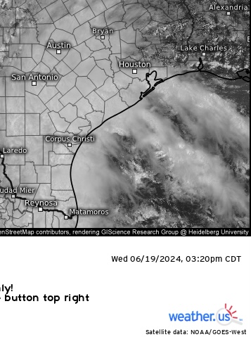
PW is now just under 3 in. on Corpus 0z obs upper-air sounding this evening (models had insisted 3 since the past week). 2.8 in. on Brownsville sounding. - VWP, on Corpus radar showing 40 kts easterly (tilting southeasterly ML) flow now this evening. But getting next to 50 kts now around 5 Kft on Brownsville radar. Wind has picked up again here on the ground also and been getting somewhat more sustained TS storm force winds in the bands moving ashore a few hours ago before dark. CAPE has picked up, as well as Effective & BRN shear values have sig picked up into supercell range now (both about 40). Tropical supercells are usually only transient with very brief & localized spin-ups (and obviously no hail due to very high FZL in these fully tropical environments). But SPC of course, has posted a tornado watch until 7 am tomorrow: https://www.spc.noaa.gov/products/watch/ww0437.html -
Texas 2024 Discussion/Observations
Stx_Thunder replied to Stx_Thunder's topic in Central/Western States
Likely so, which explains why there isn’t too much going on east, offshore right now. I’m even seeing some areas of ‘clear sky’ on vis satellite east of Brownsville. But also, seeing more deep convection starting to wrap around Alberto further southeast. The center of circulation is pretty evident on daytime satellite right now in the SW Gulf. I’m waiting to get on the ‘feeder side’ as there’s usually more persistent deep convection & thunder activity (obviously very high(est) rain rates) on the Eastern periphery of the circulation. All the very deep moist DL inflow coming from southeastern Gulf & Caribbean. ML lapse rates are typically more elevated in that region with these tropical systems (6 - 7 range). Can see 2 fairly notable feeder bands offshore to the east, with one starting to train into SETX. It should start to fill in again offshore in the next couple hours (but especially this evening).