-
Posts
385 -
Joined
Content Type
Profiles
Blogs
Forums
American Weather
Media Demo
Store
Gallery
Everything posted by Stx_Thunder
-

Texas 2024 Discussion/Observations
Stx_Thunder replied to Stx_Thunder's topic in Central/Western States
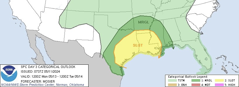
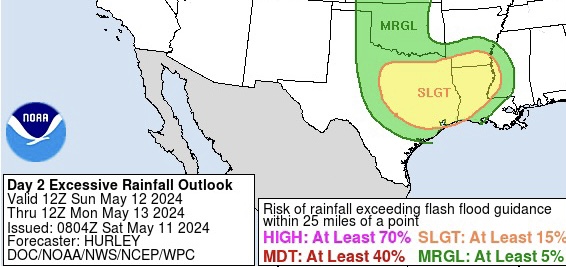
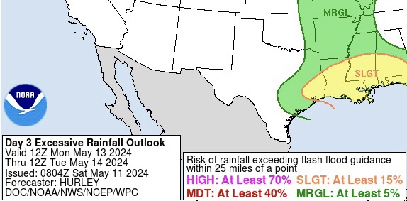
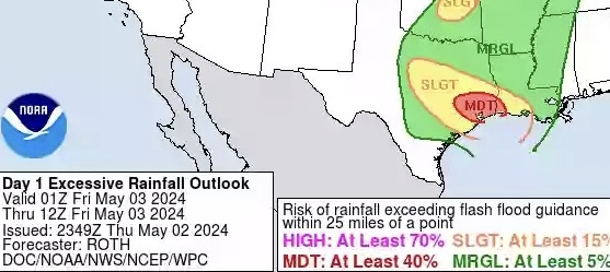
Looking pretty favorable for both severe (hail/damaging winds) & flooding on Monday. More MCS activity likely over ETX, but especially SETX overall (front will be hanging around there also), with decent DL shear for mid May (40 - 50 kts), instability and support for lift aloft from the next incoming Low into the plains on both GFS & Euro latest runs. SPC now has fairly large slight risk for eastern half on Monday. WPC’s ERO has possible moderate risk upgrade on Sunday, but will probably also expand Monday's ERO slight risk to cover most of SETX or Houston area also. Especially with the continued model projection of 2”+ PW pooling ahead of the front around there. Already seeing some evidence of that potential on Brownsville (BRO) 12z observed sounding this morning with PW at 1.98”, where front is currently meandering in deep STX also causing some elevated convective activity as of typing this post this morning. Other typical storms/supercells are expected to develop out west over Mexican terrain later this afternoon and progress east into hill country and south into STX. But 12z HRRR also showing new development around Houston area overnight into Sunday morning. - - - -

Texas 2024 Discussion/Observations
Stx_Thunder replied to Stx_Thunder's topic in Central/Western States
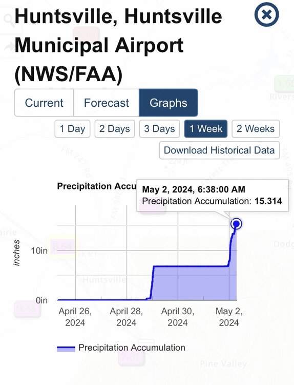
Definitely not dropping the flooding tag (at least for another week or two, possibly not till June). Both GFS & Euro have been stepping up since early this week on rainfall totals for the eastern half with another meandering front involved, into next week. Not surprised at all as in/out heavy rainfall & flood provoking MCS activity is typical for May just about every year nowadays. Especially coming out of a formidable EN winter and what’s already been going on still only being in the beginning of month. ETX rainfall totals for the past 30 days must be either at or very near 30 inches in some spots (like Huntsville area) now in that > 20” white area. -

Texas 2024 Discussion/Observations
Stx_Thunder replied to Stx_Thunder's topic in Central/Western States
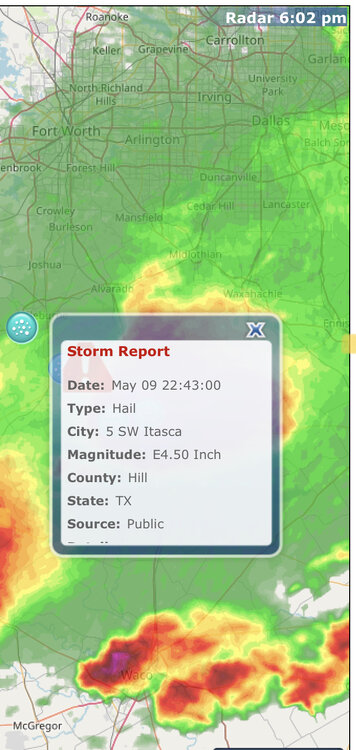
Possible grapefruit hailer with that supercell that went just southwest of Fort Worth a little while ago. - - - Lots of hail reports with basically all kinds of diameter all around DFW area so far today. Exactly my thoughts when I saw that McAllen temp info post. Nothing unusual there with 100s by May. Even sometimes as early as March in the past. Not to mention, even Kingsville was easily having that along with HI near 130 last June here around STX. -

Texas 2024 Discussion/Observations
Stx_Thunder replied to Stx_Thunder's topic in Central/Western States
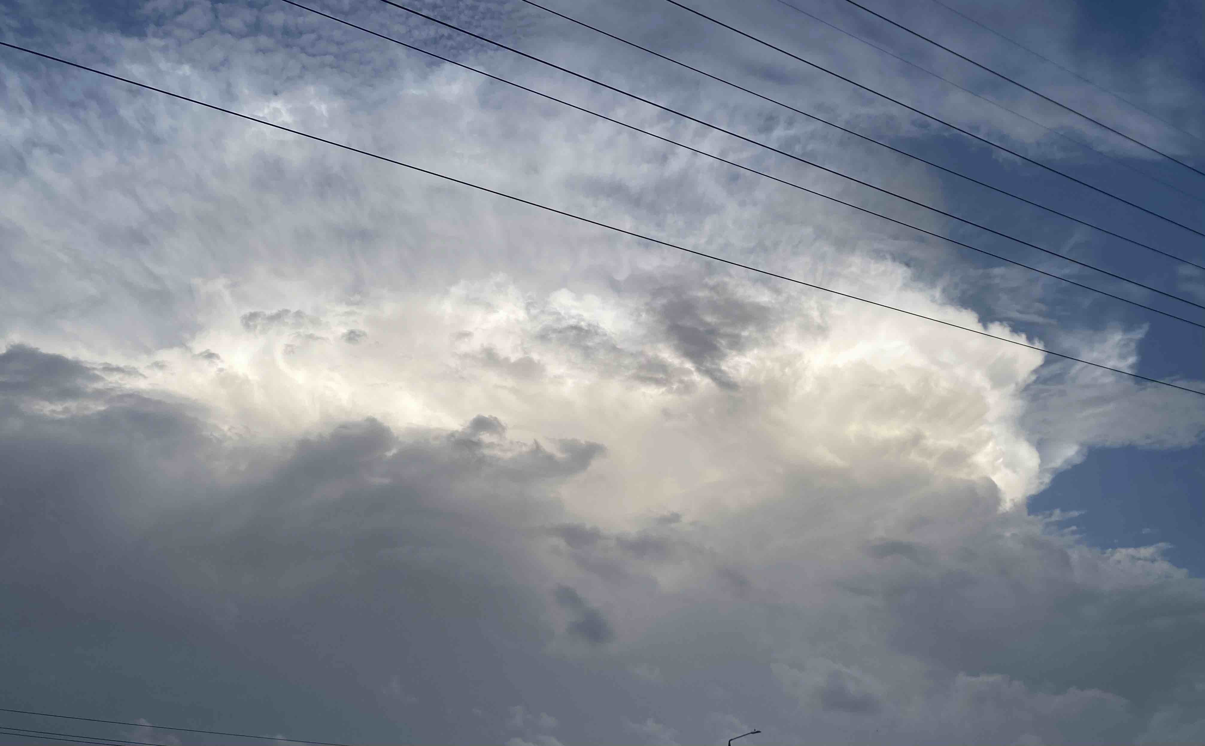
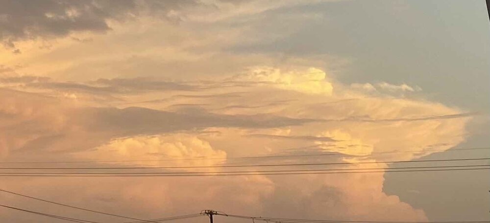
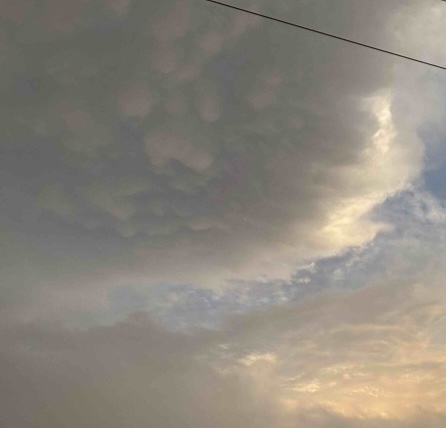
Didn’t see or hear much where I was Sunday afternoon - evening except for 2 decent +CGs nearby outside of all the cells that day. Though I did manage to capture some photo-worthy, near sunset storm clouds off to the south/east as the trailing MCV that caused the storms over the Rio Grande plains & brush country (south of San Antonio), went southeast into deep STX with a last gasp of cells before everything just fell apart at nightfall. Apparently was mainly day heating-sustained, but did see an EML around 850mb on Brownsville 0z sounding that evening. Took the photos just after 8 pm. * Saw several CG jumpers (clear air strikes from upper body) about a minute apart from each other on that strongest, rightmost/southernmost cell with the mushroom anvil & overshooting top. Didn’t stay mature like that for long though, and I didn’t even have to look at the radar at all while I was watching it outside with the last of daylight to know it was already having trouble maintaining itself. Both the overshooting top & mushroom anvil flanked out pretty quick after I took that photo. No more than 20 minutes at most. - - - -

Severe Weather 5-6 through 5-9-24
Stx_Thunder replied to cheese007's topic in Central/Western States
80 mph wind gusts would be the reason if so when I read that warning. Which is considered destructive thunderstorm damage. I don’t remember if I’ve ever seen a PDS severe thunderstorm warning. But do remember seeing a PDS severe thunderstorm watch on SPC a few years ago (which I also never thought existed and is rare). -

Texas 2024 Discussion/Observations
Stx_Thunder replied to Stx_Thunder's topic in Central/Western States
Heard one very good rumble when some cells popped up nearby a couple hours ago (a good sign for me today especially having missed out on all the convective energy & action up north during this past week). Watching the cells this afternoon southwest of San Antonio that are currently gathering along the boundary that can be seen fairly well now with all the activity ongoing from Del Rio - Houston. https://www.spc.noaa.gov/products/watch/ww0186.html https://www.spc.noaa.gov/products/md/md0639.html Given these early May afternoon convective scenarios down around here in the past, a few discrete, usually large HP supercells tend to erupt along such outflow fronts and move southeast all the way to the coastal bend before dissipating when they move off the coast. HRRR was also really hinting at that on yesterday evening 0z run. 12z ARW-2 run this morning seems to have a pretty good handle on what’s going on today. Though I wouldn’t be surprised if one or two supercells manage to get down into deep STX also. Second round moving into Houston now. Definitely would not say things are done around there (possibly more organized 3rd or even 4th round). At least until this evening as there’s definitely a boundary hanging around there and another shortwave (causing the new storms southwest of San Antonio) that will be approaching SETX later this afternoon. -

Texas 2024 Discussion/Observations
Stx_Thunder replied to Stx_Thunder's topic in Central/Western States
https://www.wpc.ncep.noaa.gov/metwatch/metwatch_mpd_multi.php?md=0228&yr=2024 -

Texas 2024 Discussion/Observations
Stx_Thunder replied to Stx_Thunder's topic in Central/Western States
-

Texas 2024 Discussion/Observations
Stx_Thunder replied to Stx_Thunder's topic in Central/Western States
Looks like solid MCS activity across most of the state tonight - Sunday with some pretty strong ML shortwave energy coming in. Already seeing some robust clustering going on right now with initial thunder development over Panhandle region. WPC going with another moderate risk area right around Houston through tomorrow (they’ll likely have to maintain that). I reckon 30-day rainfall totals just northeast of there in East TX will be 30 inches (potentially even higher looking at Sunday’s rainfall/flood parameters), by Tuesday morning TexMesonet update. Both Euro & GFS showing fairly substantial at or near 2” PW pooling (which can definitely happen by May) going on into Sunday, generally between San Antonio - Houston area (there looks to be a stalled front set up in this region), and south to the coast. - The Euro has an extreme weather index value between 0.1 - 0.99 for 24-hour rainfall, and it’s been verifying pretty well with near 0.7 values & higher, since about 2 weeks ago now of the flood-producing MCSs in East TX. - - - - - It’s looking more likely that such records north of Houston are going to be broken after tomorrow’s activity. Which looks to be pretty heavy seeing all the 500mb shortwave energy moving through the state tonight - Sunday with even deeper moisture interaction because of a stalled front hanging around your area. Which definitely provides focus for heavier activity and training cells. Seeing it’ll all be through Sunday, you should be able to enjoy all the action going on before the new work week starts -
Got a near grapefruit hailer, lone HP supercell near the middle Rio Grande south of Del Rio TX. With that intensity, the core will likely miss Laredo (but could try to cross the river next to Zapata into deep STX in a while). It’s a pretty big cell that should have no problem sustaining itself for the next couple of hours out there with very easy access to the very warm/humid & highly untapped environment downstream southeast and backed low-level moist inflow from the Gulf. Storm top easily next to 60 Kft right now on ET radar imagery in Del Rio (DFX) site.
-

Texas 2024 Discussion/Observations
Stx_Thunder replied to Stx_Thunder's topic in Central/Western States
East Tex = SOAKED (and still not done yet) -
Very favorable convective environment today around here in South TX. 12z CRP sounding early this morning is unusually, 99% un-capped, with 50 kts effective shear. Though still more capped in Deep STX on 12z Brownsville (BRO) sounding. It’s virtually been like that most of this week. Though I have been getting a few showers this week and there was a very good amount of towering cumulus yesterday afternoon in the overcast deck. The only (simple) problem? Been missing out on the shortwaves that have been bypassing further north tracking through the state (that should change by tonight). I suspect SPC is going to expand that marginal risk further east and possibly include a possible slight risk expansion or separate risk area later today somewhere around Del Rio - Laredo region for those typical Mexican terrain supercells that will likely flare up vigorously with all the heat/humidity (AON 100 F) out there this afternoon, and more incoming ML shortwave energy out west, going east. But also more interestingly, may have outflow influence moving southwest further down the coast from the flood-causing convection still going on in Houston area this morning, causing new cells to pop up in Victoria area and organize. I can see the fairly definitive boundary moving southwest (leaving Houston area right now) on radar with new cells trying to get going along & just behind it.
-
Wondering if anyone on here has any kind of portable or handheld lightning detection device, or experience using those. Not most commercial types or ones that you have to hook up to a computer with corresponding software in order to see the strikes it detects on a map (accurate real-time lightning data is very easy to see online now thanks to all the global lightning detection networks out there). Though in any case, just like wx station devices, am creating this topic also to make note of these more unique kind of physical wx tools on here. - - - - - https://skyscanusa.com/product/skyscan-p5-3-lightning-detector/ I have a portable, “tabletop” P5 detector by ‘SkyScan’ and have had the same exact one I bought since 2006. The one now sold on the site (P5-3) is the newest model. The older one I have is white. But even after all these years of having the much older model, it still does a very good job picking up just about every single CG strike close by and in the accurate range indicator (though it can also pick up stronger cloud discharges). It was 100% worth the $200 investment, but it might’ve been slightly less than that back then in the 2000s. Like $180 (including shipping). Though I reckon the newest P5-3 model now sold is even more precisely accurate (SkyScan claims 95% on it). I keep my old model plugged into the provided wall outlet AC adapter and it does have an actual electromagnetic interference detection feature in its hardware as well to eliminate false strike detection for the most part. The micro CPU hardware in personal lightning detection devices like my SkyScan are designed to pick up the EMP activity or rather, ‘signal’ triggered by an actual lightning strike, then processes it to determine its distance, etc. - This happens instantaneously (as soon as the detected strike occurs). The farthest range indicator on that detector is 20 - 40 miles, but it can actually pick up strikes that are much further than that (like 150 miles here and there or basically, if it can be seen dimly over the horizon in a clear night sky). It also has a Severe Thunderstorm indicator, but it’s really a frequent lightning indicator which when triggered, gives off a steady tone for a whole 15 seconds. The detector tone is fairly loud, so it can wake you up at night (especially if there’s a stronger storm or complex close by or coming in depending on range selected). - - - As far as other lightning detector products are concerned, handheld ones don’t seem to do a good job of accurately calculating the distance of a strike from what I’ve been reading online in years past. Though I don’t have any personal experience using any other detectors aside from my old P5 Skyscan.
-

Texas 2024 Discussion/Observations
Stx_Thunder replied to Stx_Thunder's topic in Central/Western States
https://www.wpc.ncep.noaa.gov/metwatch/metwatch_mpd_multi.php?md=213&yr=2024 -

Texas 2024 Discussion/Observations
Stx_Thunder replied to Stx_Thunder's topic in Central/Western States
Definitely looks like more flooding in East TX early this morning. Especially in Huntsville area and/or just north/east of Houston area once again with that next MCC upstream moving fairly slow southeast (just south of DFW area). But intensity could be limited overall this time with all of last night’s activity causing some stability in that part of the state. Though FFGs (flash flood guidance values) are already very low around Huntsville area and pretty much all around there too, so it won’t take much more rain at all now. WPC maintaining Moderate risk in Houston area, but 850mb flow is now apparently (but modestly) deep out of the southwest on Houston VWP radar so that’s probably going to limit convective intensity a good amount with new development more likely further east unless an MCV comes right next to Houston. Tonight’s 0z ARW run has a fairly good handle on the ongoing thunder system in north-central part of state moving through most if not all of SETX in some organized form later this morning (some remnant boundaries from yesterdays activity in the area to work with also around there). -

Texas 2024 Discussion/Observations
Stx_Thunder replied to Stx_Thunder's topic in Central/Western States
Multiple reports early this morning of impassable roads from another 8 - 10 inches in waterlogged Huntsville area, from the MCS activity going on in East TX since early yesterday evening (Wednesday). https://www.wpc.ncep.noaa.gov/metwatch/metwatch_mpd_multi.php?md=0208&yr=2024 -

Texas 2024 Discussion/Observations
Stx_Thunder replied to Stx_Thunder's topic in Central/Western States
Seeing reports of numerous road closures and water over roads in Madisonville and Huntsville areas from that persistent, slow-moving and pretty potent MCS (seeing pretty cold cloud tops near -80 C not far northeast of Houston area on satellite). Rainfall totals at or over 10 inches in some spots around that part of East TX also. A well-defined outflow should crawl into Houston within the next few hours and storms may persist a good part of this morning around there as seeing the LLJ maintaining at least 30 knots (seeing 35 now on Houston VWP radar still generally southerly in the lower levels). - - - - -https://www.wpc.ncep.noaa.gov/metwatch/metwatch_mpd_multi.php?md=0200&yr=2024 - - - ***** Later this week: -

Texas 2024 Discussion/Observations
Stx_Thunder replied to Stx_Thunder's topic in Central/Western States
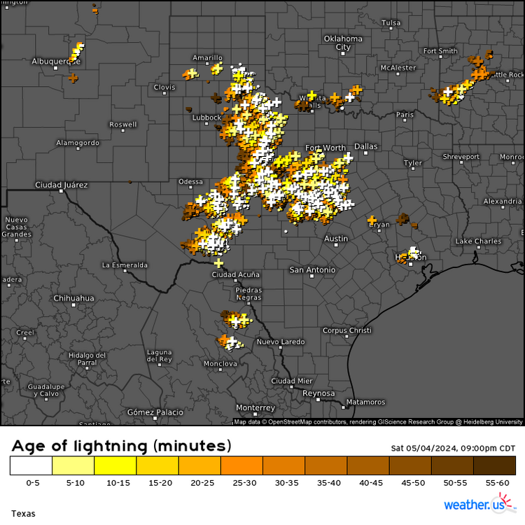
I think you’re gonna have more overnight wake ups in May now that we’re getting into peak MCS month (and especially coming out of a fairly strong EN winter). They tend to happen (and peak in intensity) more often during night. Anyone can see those multi-global model consensus thunder probability maps (and most other maps/model data on there) completely free & easily on https://weather.us I just post those on here to be informative CRP 0z observed sounding this evening showing pretty favorable convective environment over STX (more typical now getting into May). Just of course, lacking the necessary lift off to the north/east and doesn’t look like anything till sometime tomorrow/Tuesday. That shouldn’t be a problem in Houston area tonight (but could be on west end of it). Should be a pretty good thunder show there overnight as that MCS in East TX is taking its time propagating south this evening (could be higher end flood threat that region next several hours). WPC highlighting flooding likely in MCD for that region this evening. Also seeing a really good amount of positive CGs just like in the QLCS that moved through northern half of state last night. -

Texas 2024 Discussion/Observations
Stx_Thunder replied to Stx_Thunder's topic in Central/Western States
High water rescues were going on in Kaufman, in the NETX MCS this afternoon. DFW radar estimating a southwest-northeast strip of significant rainfall. Embedded 7-inch storm totals in that area southeast of Dallas. -

Texas 2024 Discussion/Observations
Stx_Thunder replied to Stx_Thunder's topic in Central/Western States
Must be a fairly strong shortwave coming into the state today. Despite pretty strong BL capping and warm 700Mb temps on sounding data down here early this morning, had an elevated storm still manage to get going nearby tapping into >8 ML lapse rates with a good amount of CGs (though thin & weak on lightning analysis), within the past hour or two. -

Texas 2024 Discussion/Observations
Stx_Thunder replied to Stx_Thunder's topic in Central/Western States
Lots of 40s / lower 50s across the state Monday morning. Very comfortable 70 degree high & 50s DP down here (which are not common by this time of year), and had elevated storms moving around me both Sunday (with a good amount of small hail droppers, interestingly), and Monday mornings. Which was a good cherry on top. Last hurrah frontal airmass of spring outside was good while it “lasted”, very early this week. That looks to be about it for TX comfort season until later fall - Onto MCS month, coming up. That convective/supercell phenomena out there west/southwest of Laredo over the open Mexican terrain east of the Sierra mountains is MUCH more common during the Spring months, every year than you might be thinking. The orographic lift from those mountains further west is also what encourages the development out there over the flat terrain. -

Texas 2024 Discussion/Observations
Stx_Thunder replied to Stx_Thunder's topic in Central/Western States
Just as I suspected on my first post from Thursday, 40s now in DFW by this evening with all the convective activity & resulting evaporative cooling effects going on behind the polar front today. Models not doing the best on convective placement. But GFS & 12z HRRR run this morning seem to have the ‘best’ handle on storms going on in the state today. -

Texas 2024 Discussion/Observations
Stx_Thunder replied to Stx_Thunder's topic in Central/Western States
Both GFS & Euro last night forecasting generally 5 in. area totals for this weekend’s system/polar front or large linear MCS activity tonight between Dallas & Houston region. Doesn’t look like enough for sig flooding even though WPC has large (supposedly higher-end threat) excessive rainfall slight risk in D1 outlook/discussion, and despite parts of East TX seeing a good amount of rainfall in recent weeks. *** Should also add, HRRR not the most reliable as it always tends to overdo its convective depictions. Which is why stronger updrafts and severe can never actually be ruled out in elevated storms with enough DL/effective shear (especially nowadays). 12z observed DFW sounding this morning was also showing high elevated CAPE & LI just under 800 Mb layer. Even though ML lapse rates a bit meager (just about 7). -

Texas 2024 Discussion/Observations
Stx_Thunder replied to Stx_Thunder's topic in Central/Western States
I think it has more to do with how late it is in the season (being right next to May now), so more people are not convinced that it would happen. Though it has before on climate history in the past 2 decades but even then, the cooling effects don’t last at all in this state when it does. March was dismally warm & humid for the most part (at least in the southern half), and it’s already been feeling a lot like summer with almost constant 70+ dew points in STX for some weeks now (save for just a few modest comfort-bringing fronts). So even though it doesn’t look like this weekend’s polar front is going to have enough gas to completely push off the whole TX coast, I’m really going to enjoy it as much as I possibly can as I should get down into the 50s for one night at least. After this, not seeing any other kind of comforting frontal airmass intrusions at all into the state on main models. Just total TX summer junk wx into early May with more 90 F temps showing up and growing HX. Away from any convective or MCS potential effects as we’ll be entering peak spring MCS month for the state in May. Everyone who’s not new to living in this state already knows what summer here is like Every year for literally about half of the entire year until October with 0 actual cold fronts through the state. Sometimes not until November here in STX. That just literally sucks every single year. -

Texas 2024 Discussion/Observations
Stx_Thunder replied to Stx_Thunder's topic in Central/Western States
A little surprised nothing still hasn’t been mentioned at all about it on here (only being 2 days away now), but 2023 - 24 winter, is not actually done completely for TX just yet.. GFS has been consistent on it for a week now, and now that the AO has apparently entered a new negative phase, a very late season Polar front looks to edge through most, if not entire state by Sunday night (even though airmass duration is obviously going to be brief being next to May now). Canadian now showing lows Monday morning (22nd), in the 30s near DFW (I’m sure this is still significantly below normal for later April standards up there). 40s, San Antonio & Houston. Other models not as cold at that timeframe which explains why NWS is still being very conservative in state forecasts, but 12z NAM this morning (which always does best with these shallow polar and arctic air masses), at the end of run does show air temp at 50 F by Saturday evening in NTX. More likely 40s with forecast elevated thunder activity ongoing behind front Saturday afternoon, causing stronger evaporative cooling effects. Potential MCS (may be a few supercells/iso severe with 40kt DL shear on Euro) further south moving through the central/southern half ahead of front into the evening Saturday. -

