
Stx_Thunder
-
Posts
409 -
Joined
Content Type
Profiles
Blogs
Forums
American Weather
Media Demo
Store
Gallery
Everything posted by Stx_Thunder
-

Texas 2026 Discussion/Observations
Stx_Thunder replied to Stx_Thunder's topic in Central/Western States
Lots of significant flood reports, including numerous impassable roads and water rescues have been coming in from the Edwards Plateau region (not far west of SAT), since Tuesday. Especially in Uvalde county where lots of rivers/creeks are now at major flood stage and overflowing their banks. Del Rio (DFX) radar storm totals are now over 2 feet in Uvalde county. This stationary Low setup in the region is similar to the one that occurred around this same time last year in 2025 (except that it's not a tropical Low entity that was the remnants of TS Barry last year which always have much deeper moisture). -
Texas 2026 Discussion/Observations
Stx_Thunder replied to Stx_Thunder's topic in Central/Western States
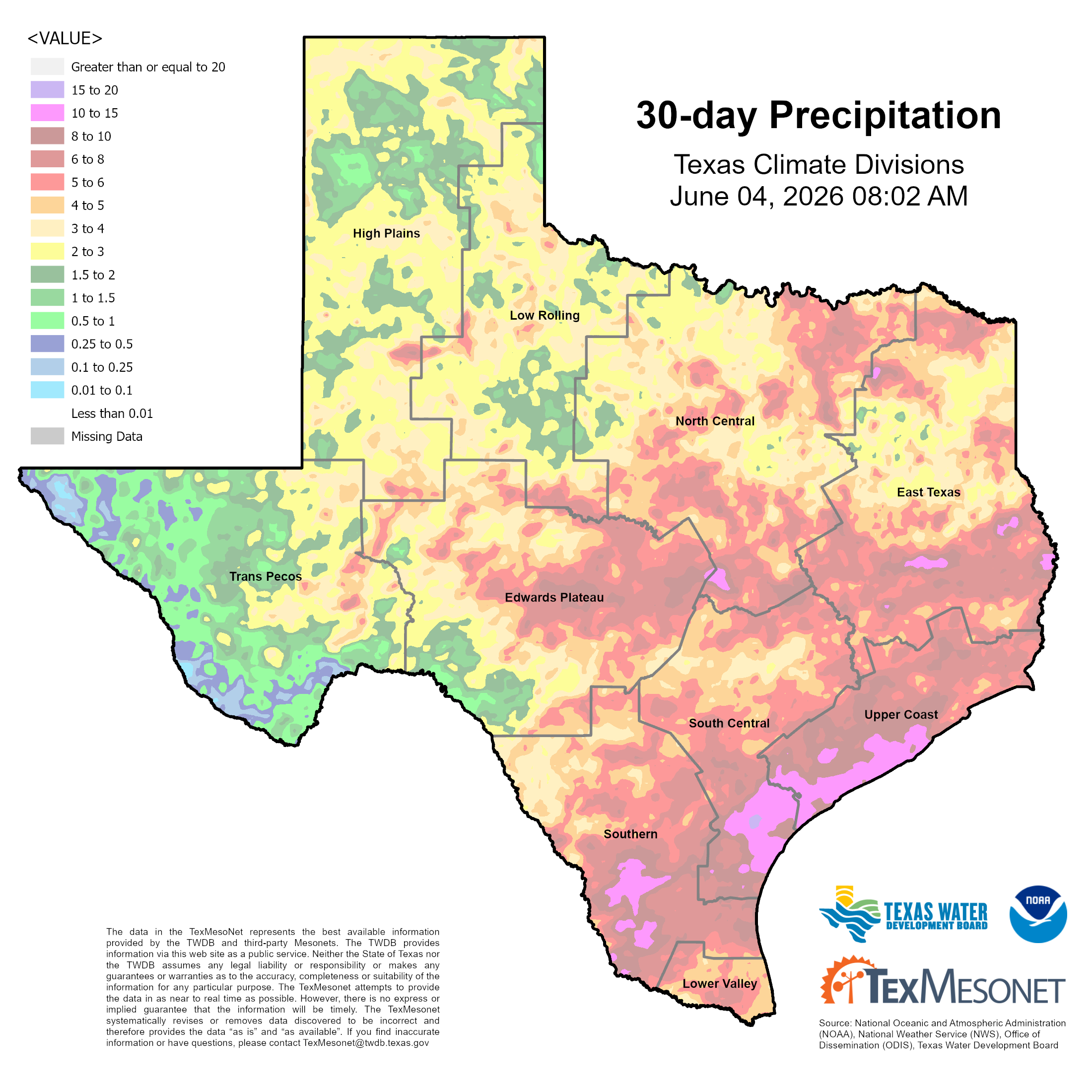
There were a very good amount of flood reports in S-SETX last week with significant river, creek, and even reservoir rises noted over much of the coastal/southern region. The mid - upper coast again, got walloped with another several or more inches (like in late May). Bringing the 30-day rainfall total this week up near 2 feet now in some spots.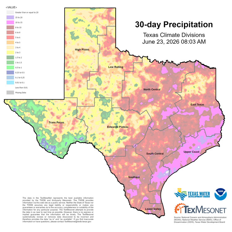
-
Texas 2026 Discussion/Observations
Stx_Thunder replied to Stx_Thunder's topic in Central/Western States
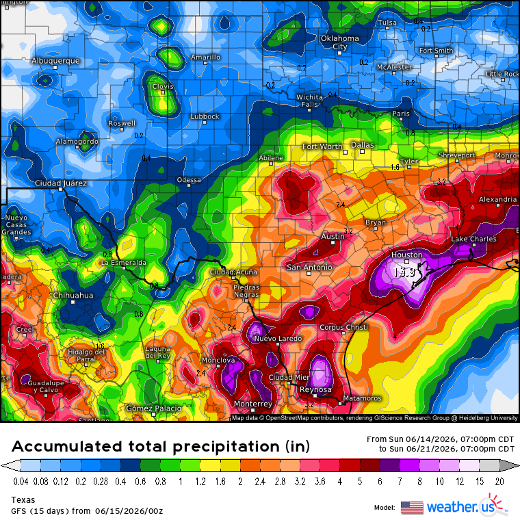
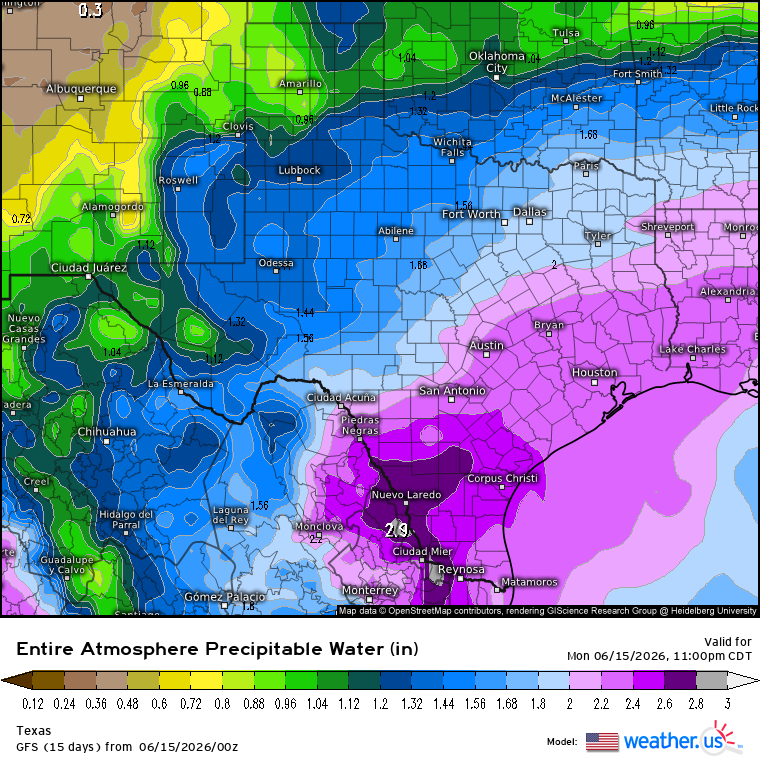
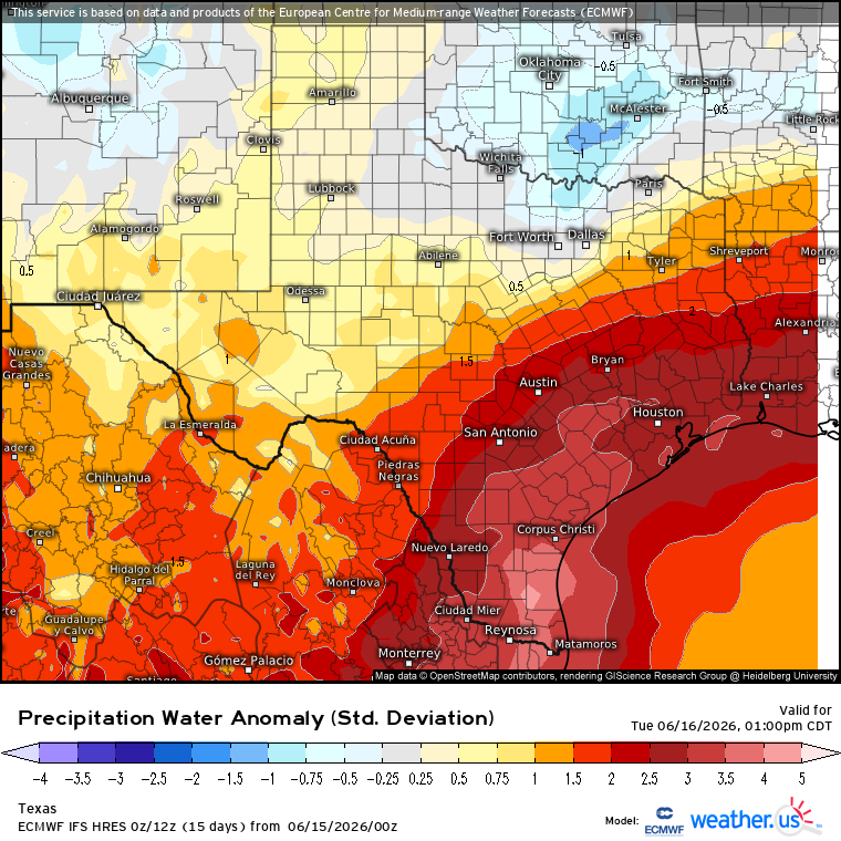
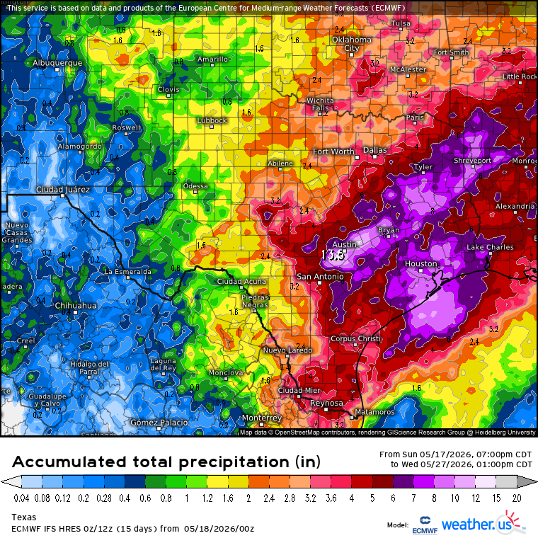
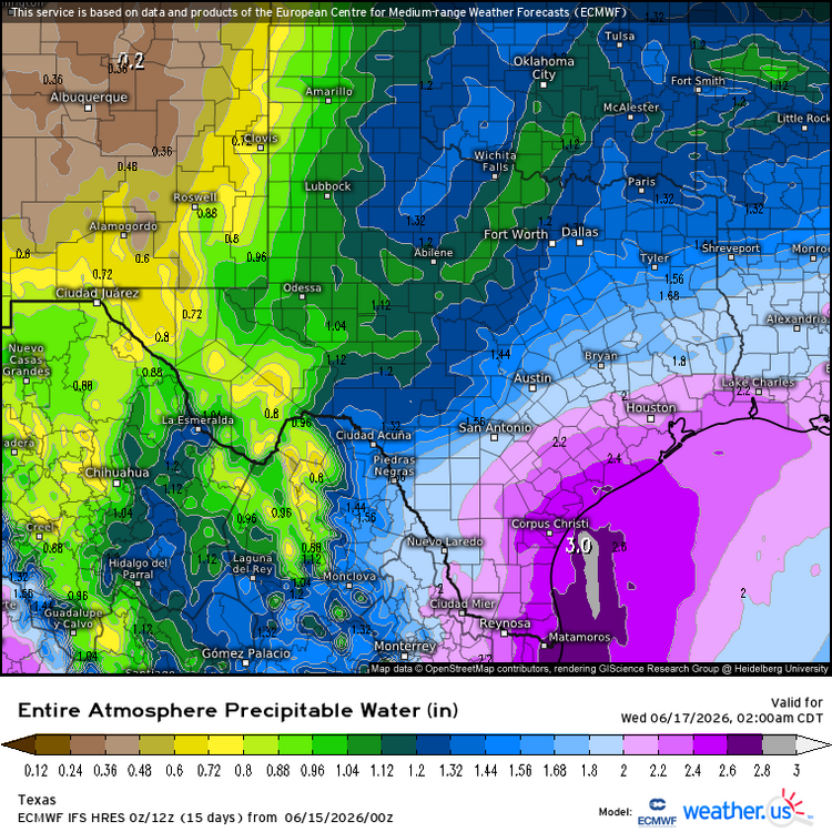
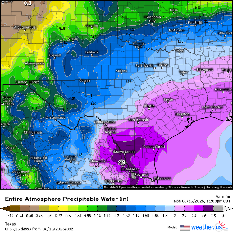
Very likely now to be wet with a W, over the Coastal region the next couple days from S-SETX. Significant flooding is almost a total guarantee due to a stalling front and the slow-moving, leftover circulation from what was TS Cristina (on Pacific side) of Central America earlier this past week. No disagreement on WPC's Moderate excessive rainfall risk area in STX (will likely get expanded east later today but could border on High risk with already saturated soils from late May heavy rainfall). Especially with Precipitable Water values extremely and 0 doubt, abnormally high for June standards (up to 3 in. Even along Lower Rio Grande!!!). There will be both, Gulf & Pacific moisture influx throughout most, if not entire troposphere. Euro has been very easily going over 10 inches on forecast accumulated total rainfall the past several days of runs. And going way higher now. Up to a whopping 30" in SETX on tonight's 0Z run. GFS is also catching up now (usually more conservative). Going over 10" on latest 0Z run tonight.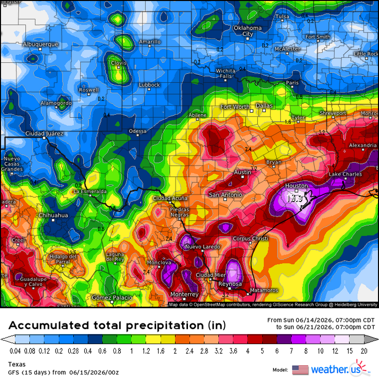

-
Texas 2026 Discussion/Observations
Stx_Thunder replied to Stx_Thunder's topic in Central/Western States
While things (might) be quieter for most of this new week, it's looking more likely now to start picking back up for mid June. More late spring type (northwest upper-flow) troughing, and MCS activity are bound to track through the state. Severe potential is there once again also. As models are trending up on shear values and steepening ML lapse rates further south in the state, into next week of June 15th. EN has certainly been making its presence known lately with no dominant summertime subtrop ridging around yet still, to actually push southern-stream jet influence away. Which continues to make things more interesting. Possibly even late June also. Which would be getting really late for that transition. -
Texas 2026 Discussion/Observations
Stx_Thunder replied to Stx_Thunder's topic in Central/Western States
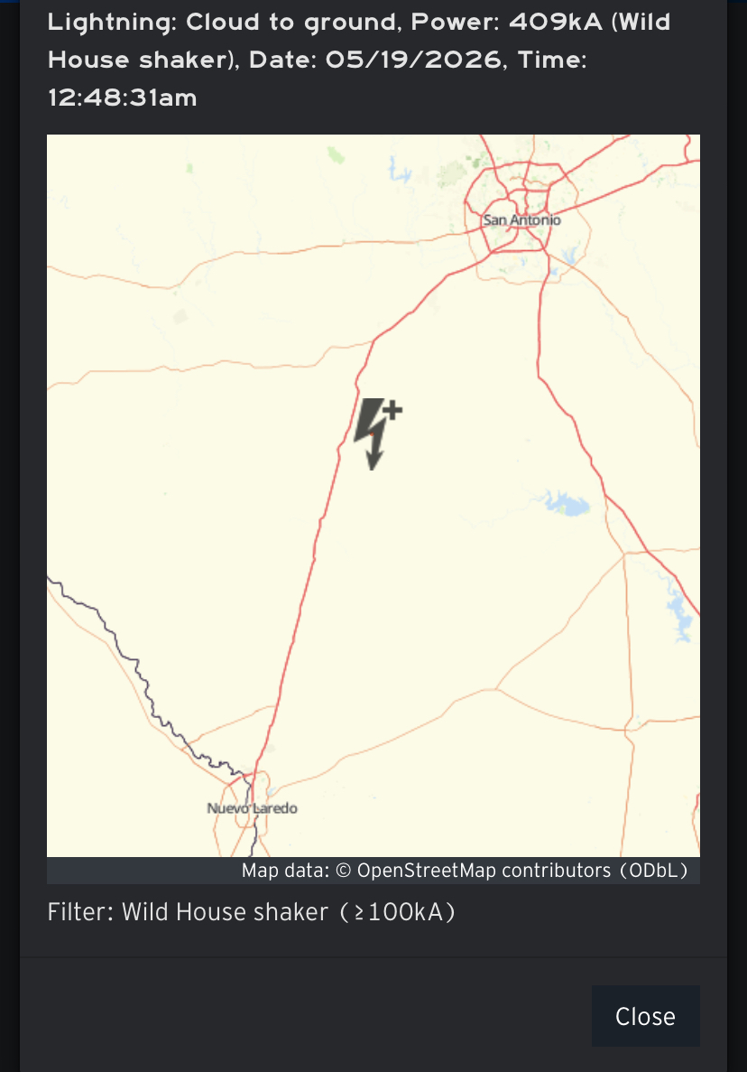
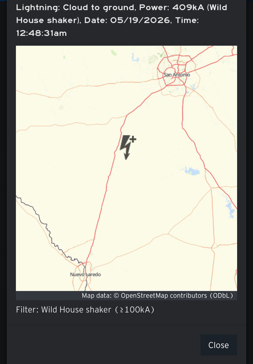
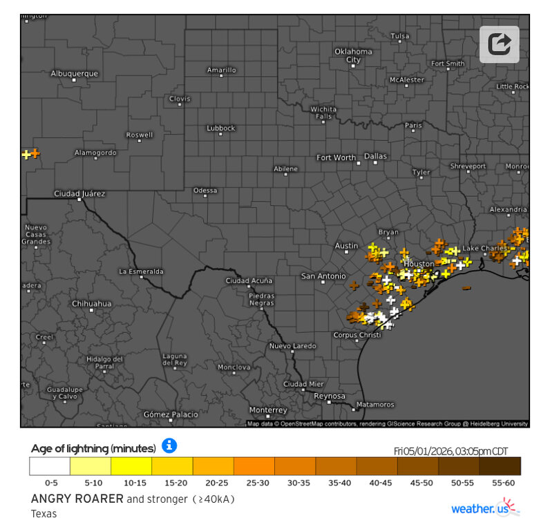
Definitely been quite substantial MCS activity the past 2 weeks before May ended. With a good amount of power outage-causing CG lightning (even structural lightning fire & damage reports also). Along with severe wind and flood reports at least over the southern part of state. With all the steep ML lapse rates (over -8) that were definitely in place, there were even a few very powerful + CG lightning strikes. And the most powerful + strike (400 kiloamps), I've ever seen on lightning strike data that must've sounded like a hydrogen bomb even 40 miles away. - - - - - S/SETX has gotten the most rainfall with over 10 inches now in the past 30 days. With even some areas over a foot in the Coastal Bend region.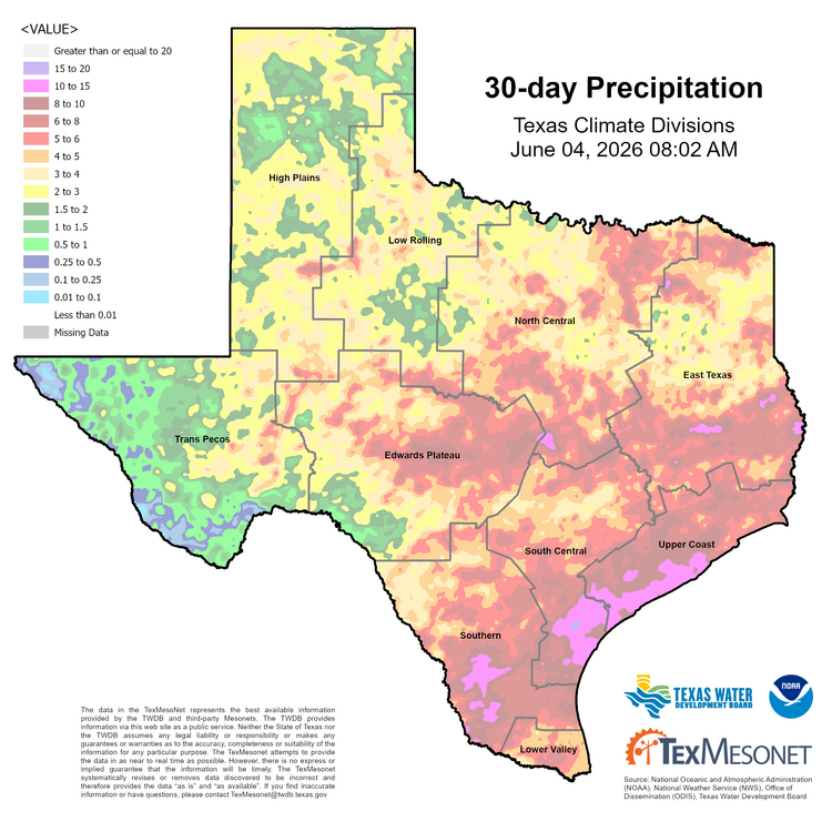
-
Texas 2026 Discussion/Observations
Stx_Thunder replied to Stx_Thunder's topic in Central/Western States
Definitely still looks to be nothing short of convectively interesting this week. And potentially even next week also. Models still going abnormally steep on ML lapse rates (> 8) over much of the state for at least the early part of this week, with at least some DL shear to work with also. A few large, strong/severe MCSs are bound to happen in the eastern/southern half of state early this week. Aside from svr risk, the flood threat also looks to increase later this week as well with precipitable water values likely going over 2" from S - ETX. Both Euro & GFS even going up to 2.5" at times too. Which is well above normal anywhere in the state in May. Latest Euro run tonight now going over a foot of rain in CTX through early next week! It's been steadily increasing over the past several days with GFS not far behind either. Significant flooding is definitely not out of the question either with storm training another distinct possibility through next week. Especially, a front hanging in the state during this week.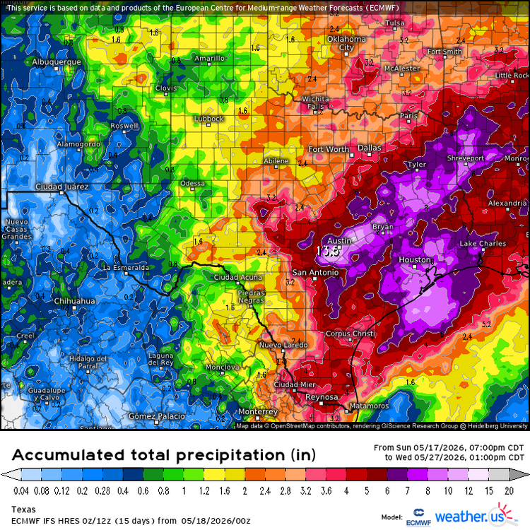
-
Texas 2026 Discussion/Observations
Stx_Thunder replied to Stx_Thunder's topic in Central/Western States
Water has indeed been piling up within the past few weeks. And definitely does not appear to be over, with storms (and attendant svr risk) likely to return next week (17th).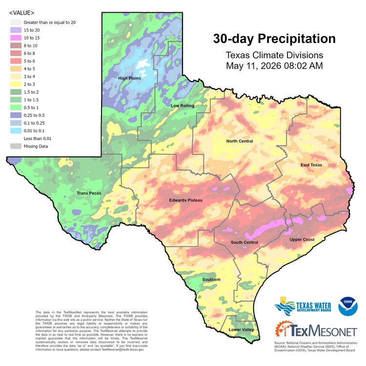
-
Texas 2026 Discussion/Observations
Stx_Thunder replied to Stx_Thunder's topic in Central/Western States
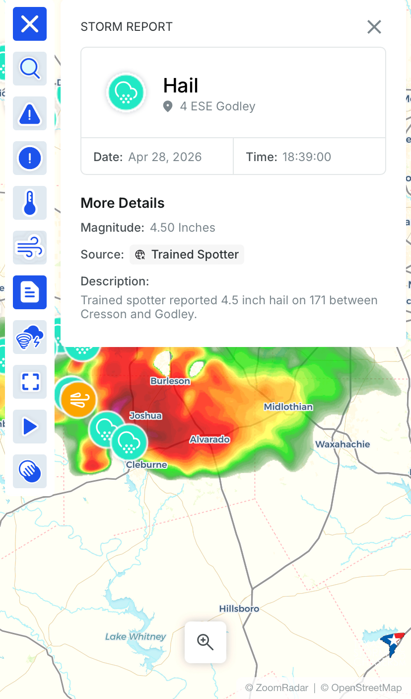
https://www.americanwx.com/bb/topic/62492-texas-2026-discussionobservations/?do=findComment&comment=8079563 5" measured hail was reported back on April 29 from a lone (fully discrete) HP supercell not far out west of SAT. Hailstones that big can definitely kill if struck on the head. Especially because they're much heavier, and obviously fall faster than smaller ones. Typically well over 100 mph when they get that big. Hail stones in the southwestern region do tend to be the largest in this state, as I've seen over the years. The supercells that popped up there in SWTX that evening of April 29 easily had tops of 60 Kft on ET radar imagery. Which easily contributes to bigger hail production in them this time of year. Although HP supercell tops >50 (and over the neighboring Mexican terrain), are quite common around there in the later spring. And in STX. -
Texas 2026 Discussion/Observations
Stx_Thunder replied to Stx_Thunder's topic in Central/Western States
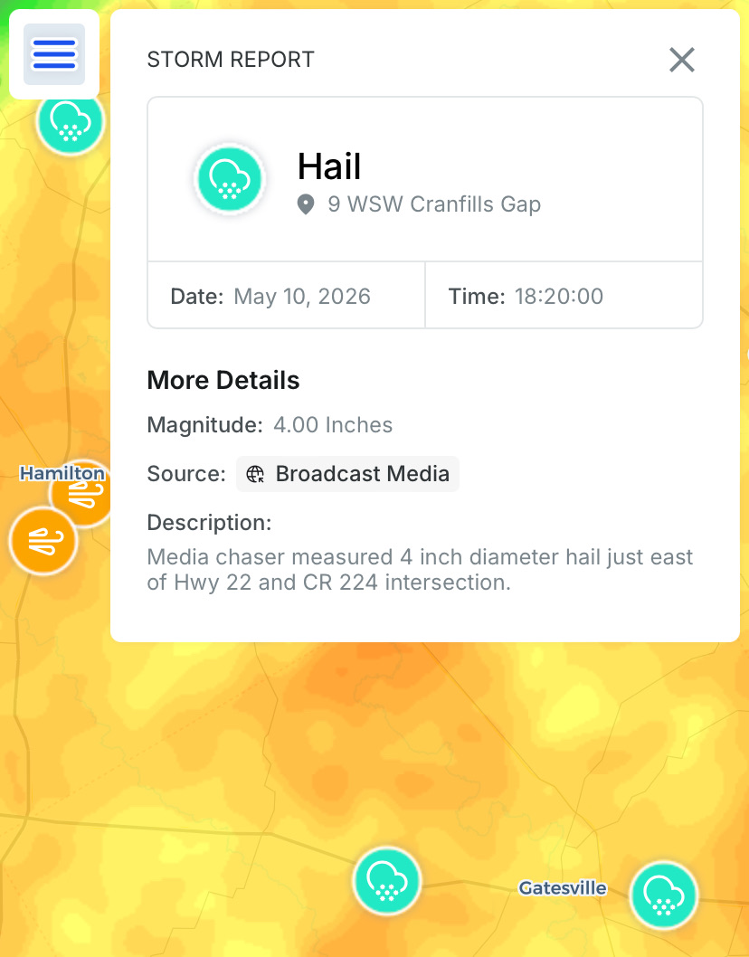
4.00 in. hail report with that HP supercell just east of Hamilton. That storm had an awesome, turquoise color, solid hail core shaft.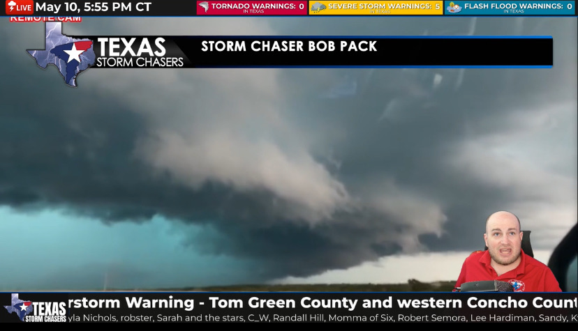

-
Texas 2026 Discussion/Observations
Stx_Thunder replied to Stx_Thunder's topic in Central/Western States
Active Mothers Day across N-CTX. Lots of svr thunder warnings issued this afternoon & evening. Along with lots of svr hail, and a decent amount of wind damage reports also. Definitely lots of wind with the ongoing storms right now in CTX. Looking and hearing all the wind on the Lakeway Earthcam (near Austin), a short while ago. https://www.earthcam.com/usa/texas/lakeway/ -
Texas 2026 Discussion/Observations
Stx_Thunder replied to Stx_Thunder's topic in Central/Western States
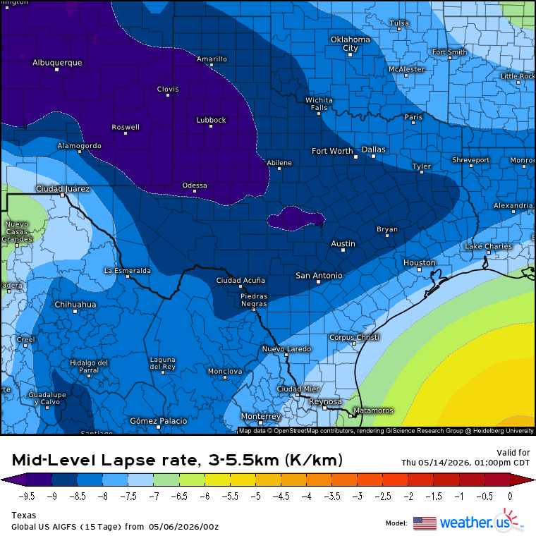
Aside from today's svr threat, things still look to remain convectively active through next week in the state, with at least a conditional svr risk later this week or weekend over the southern half. And more of the state again next week. Even if this week's front (does) manage to push south of the state, it does not look like it's going to be enough to actually shut off the thunder risk. Especially, a cutoff Low that looks to set up shop out west late this week. Not surprising being in May. But especially back in EN territory now already. There has also been a + PNA phase ongoing lately that likely also contributed to last week's bout of sig convective severe events in the state. Aside from the latter/early phase unit circle MJO. - - - Next week, what's most concerning to me right now is how steep ML Lapse Rates are forecast. Current projected values are bordering on crazy for (May) standards. Normally, no more than -7 to -8 range from what I've seen over the years in May. Steeper ML lapse rates in the state have easily been a notable trend (so far) this year. 'Definitely going to be LOTS of lightning in most cells no doubt, for sure if these kind of forecast values (-8 to -9 range) hold with ample CAPE and not much CIN likely to be in place again by late week.
-
Texas 2026 Discussion/Observations
Stx_Thunder replied to Stx_Thunder's topic in Central/Western States
Extremely interesting convective factors that lead to a (major hurricane force) straight-line wind event last Friday, over the mid-coast region around Point Comfort near Matagorda Bay. In the Victoria area. That max. recorded wind gust was even stronger than the EF-1 tornado damage (110 mph) that was surveyed in Victoria county that same day. And from the same, quite large & intense thunder cluster that developed near SAT around midday and intensified heading east-southeast toward the mid-upper coast in the early afternoon. Both that system and several other clusters late Thursday night - early Friday traveling W - E along the I-10 corridor from Del Rio - Houston (behind sfc cold front), also had a good amount of powerful + CG lightning strikes.

-
Texas 2026 Discussion/Observations
Stx_Thunder replied to Stx_Thunder's topic in Central/Western States
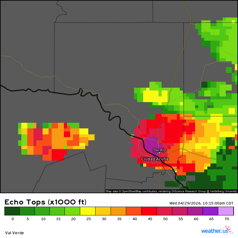
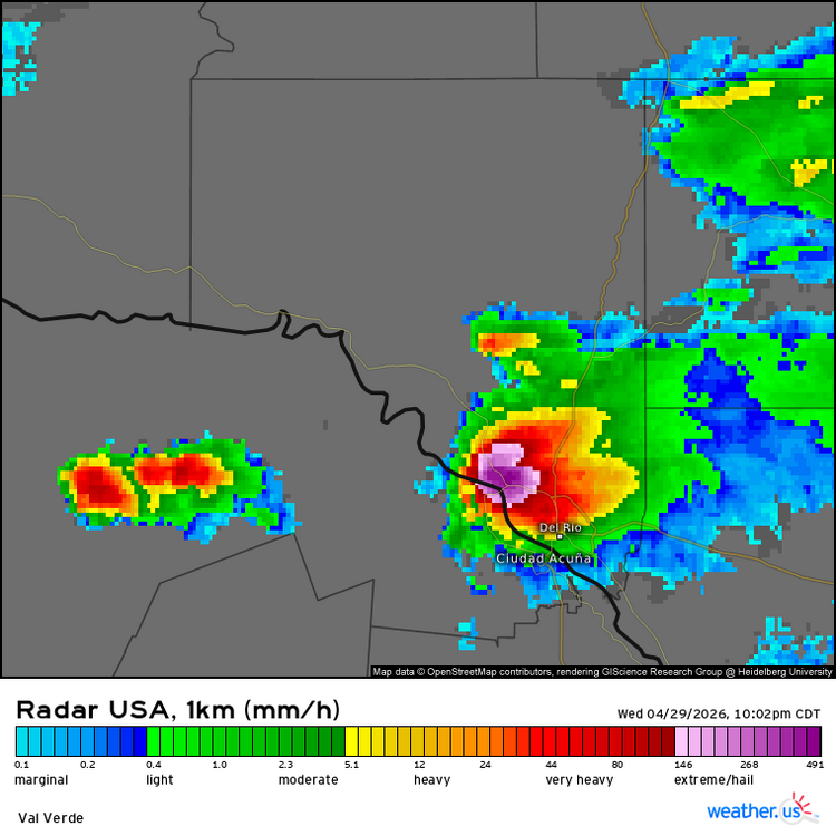
Solid supercell literally moving right over Del Rio right now. Hailstones could be even bigger than the 5 in. diameter report in Camp Wood a few hours ago. Definitely over 60 Kft tops. But could be closer to 70 !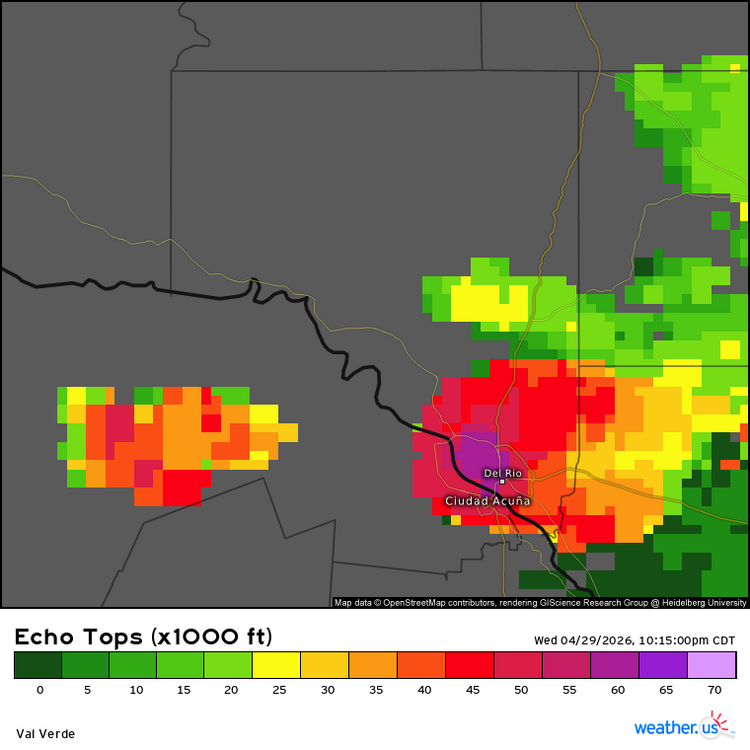
-
Texas 2026 Discussion/Observations
Stx_Thunder replied to Stx_Thunder's topic in Central/Western States
Yep. 5 in. diameter happened today with the DRT - SAT lone supercell. And still have some potential tomorrow (Thursday).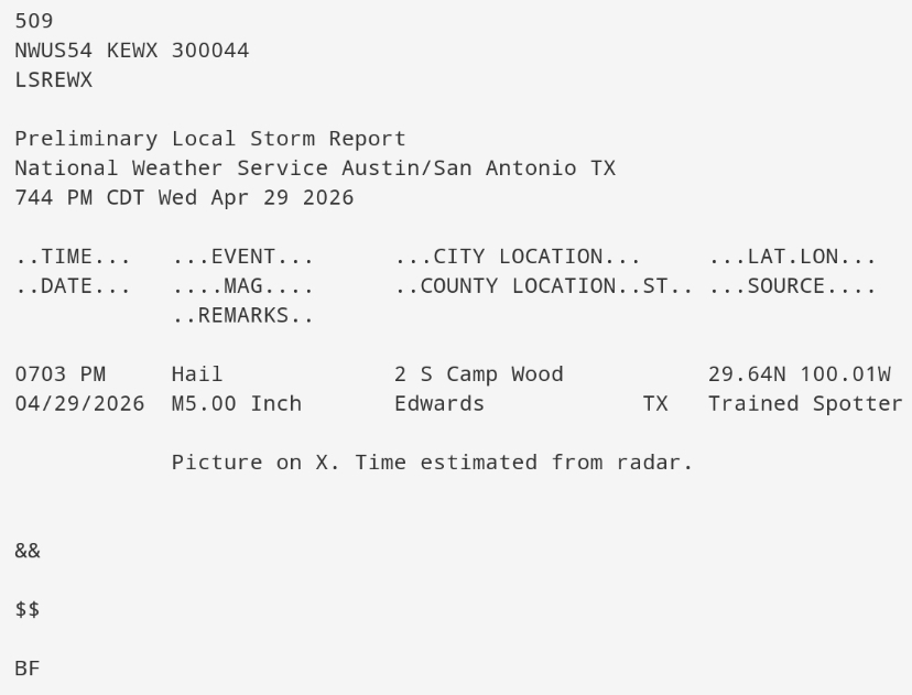
-
Texas 2026 Discussion/Observations
Stx_Thunder replied to Stx_Thunder's topic in Central/Western States
Up to 3.5 in. hailstones reported so far this evening from ongoing supercell between Del Rio - San Antonio, in Camp Wood. More severe-warned cells are coming up further west in SWTX. Which likely means next ML shortwave is entering the state in WTX. -
Texas 2026 Discussion/Observations
Stx_Thunder replied to Stx_Thunder's topic in Central/Western States
3 in. + hailstones appear to be ongoing in the elevated supercell with a very notable and large hail core on radar (sfc temp around 60 F), in Athens vicinity in NTX. -
Texas 2026 Discussion/Observations
Stx_Thunder replied to Stx_Thunder's topic in Central/Western States
SPC has (Finally) got there act together. Indicating the level 2/2 severe hail intensity area in the latest D1 outlook this afternoon, very close to SAT. Which I mostly agree on for the very large (potentially 5+ in. hail) target zone. Convective initiation is beginning in the Edwards Plateau. San Antonio area no doubt, definitely needs to be on alert through this evening. Abnormally steep ML lapse rates around & above 8, evidently remain across the state today with large hail producing elevated storms ongoing behind the sfc polar front in N-NETX. Even where sfc temps are actually in the 50s. -
Texas 2026 Discussion/Observations
Stx_Thunder replied to Stx_Thunder's topic in Central/Western States
Convective initiation could begin in N-CTX early this morning along the sagging cold front (southeast of Abilene) with the first incoming shortwave out west. Even that initial batch this morning could get severe with weakening MLCIN projected. I can already see light radar returns over Midland area, moving east as of typing this. Appears to be virga (west of the dryline), and reporting cloudy skies. -
Texas 2026 Discussion/Observations
Stx_Thunder replied to Stx_Thunder's topic in Central/Western States
Despite SPC still not forecasting much severe risk in the state today, the threat (esp. large hail) is by *no means over in the state. Euro, GFS, and HRRR are all latching now onto stronger mid-level (H5 & H7) energy trailing further south through the state today. Instead of all the unrealistically forecasted ridging over the southern half the past days. Continued moderate DL shear around 50 - 60 knots, and still steep ML lapse rates of at least 7 - 8, in C & STX. But looks to remain closer to 8. Very large hail is definitely still a distinct possibility. A giant hail stone (5 in.) might not be out of the question later today over the Edwards Plateau region (west of San Antonio), with strong sfc heating likely getting into the 90s and possibly near 100 F. Especially with the dryline out there that could get intersected by the cold front. Such near extreme daytime instability (which is typical this time of year out there) could cause some initially explosive HP supercell development as some of the CAMs are indeed showing near Del Rio later today. -
Texas 2026 Discussion/Observations
Stx_Thunder replied to Stx_Thunder's topic in Central/Western States
Grapefruit size hail reported from the fairly massive HP supercell ongoing just northwest of Cleburne. Already lots of hail reports today in NTX.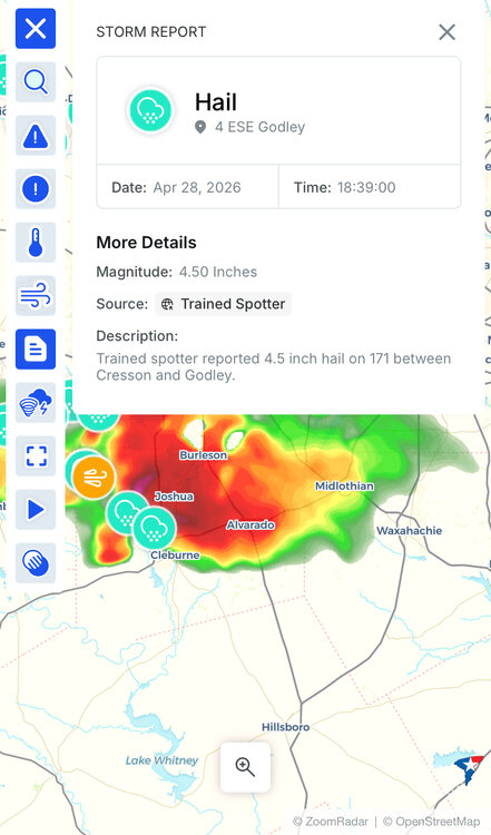
-
Texas 2026 Discussion/Observations
Stx_Thunder replied to Stx_Thunder's topic in Central/Western States
Primary threat today around DFW still looks to be svr/large hail, once again. Significant Hail Index Parameter on special 19Z UA obs this afternoon is even higher than it was on Saturday evening's 0Z UA obs that was 3.4 At 4.0 this afternoon. Definitely high for that hail parameter, no doubt. I have not seen it go that high anywhere before in the state. As far as I can remember. -
Texas 2026 Discussion/Observations
Stx_Thunder replied to Stx_Thunder's topic in Central/Western States
'Can definitely believe all the clear-air CG lightning strikes. Considering all the severe hail dumping that unfolded in DFW Saturday night. But despite what NWS claims, those more powerful +CG strikes originating from near the tops of storms can definitely strike more than 15 miles away, as I've seen before. -
Texas 2026 Discussion/Observations
Stx_Thunder replied to Stx_Thunder's topic in Central/Western States
As far as posting activity goes, nothing's changed for the almost 3 years I've been on here now. Really, the only time this state topic gets (real) activity is when snow or a tornado outbreak is forecast in NTX. Which is extremely typical on this wx forum. At least with snow. My goal here (with whatever energy & motivation I can use), is to cover all other wx aspects and parts of this big Lone Star state. Which is also why I do not include OK in these threads. Aside from that, you should already know this is a completely public thread. Anyone, can look up what's being said or discussed in here on major search engines, at least. Google is obviously a no-brainer. The thread view counter, does mean something. -
Texas 2026 Discussion/Observations
Stx_Thunder replied to Stx_Thunder's topic in Central/Western States
DFW convective environment still looks worked over from Saturday night's slow-moving, significant hail & flood producing supercells. Which wasn't even 48 hours ago yet. Mainly cloud lightning so far on current lightning data (despite sfc temps around 90 F at 7 pm). Could definitely still be some lower-end severe hail with such abnormally steep mid-level lapse rates in place (8 - 9), and modest DL shear on obs soundings across the state today. But, those abnormally steep ML lapse rates could definitely contribute to a more significant large hail threat in C/STX with more widespread, moderate DL shear overspreading the state later this week. -
Texas 2026 Discussion/Observations
Stx_Thunder replied to Stx_Thunder's topic in Central/Western States
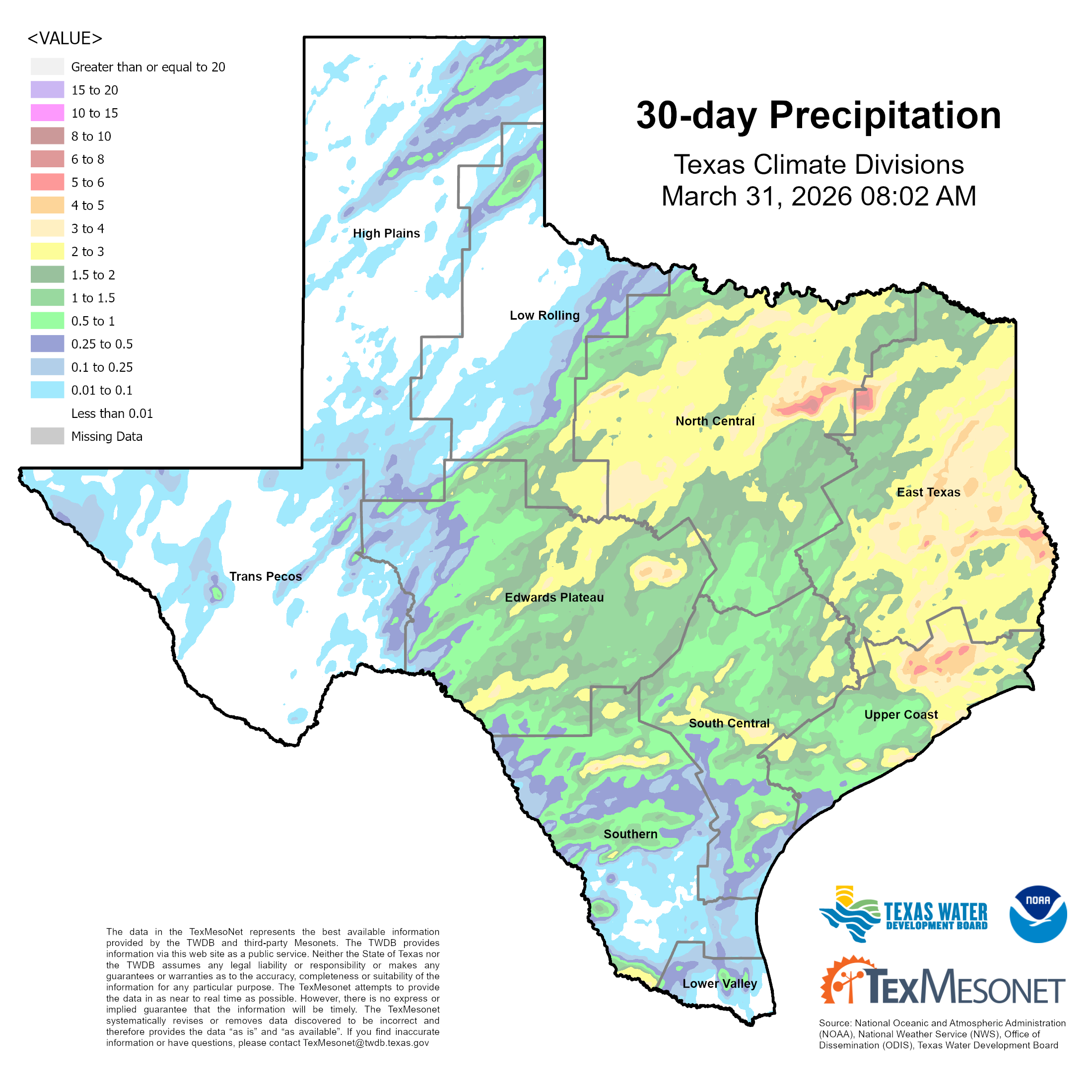
Not bad for March: Especially considering last year's March (2025) was sig drier with all the wildfires that also occurred. If we keep this up in April & May (likely a good bet now with ENSO transition back to EN territory finally underway), much of the ongoing statewide drought conditions should be taken care of at least till later summer. Things are already looking pretty wet (for the time of year) this Easter weekend with substantial MCS activity likely, and then again into mid-April.