
Stx_Thunder
-
Posts
408 -
Joined
Content Type
Profiles
Blogs
Forums
American Weather
Media Demo
Store
Gallery
Everything posted by Stx_Thunder
-

Texas 2026 Discussion/Observations
Stx_Thunder replied to Stx_Thunder's topic in Central/Western States
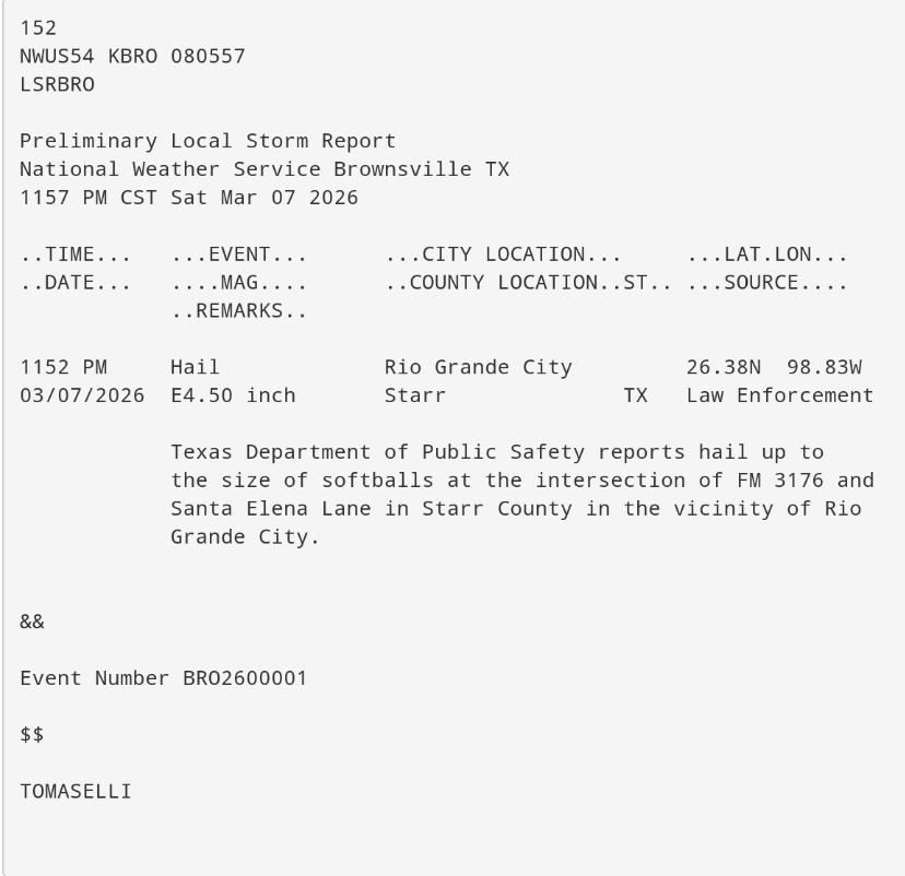
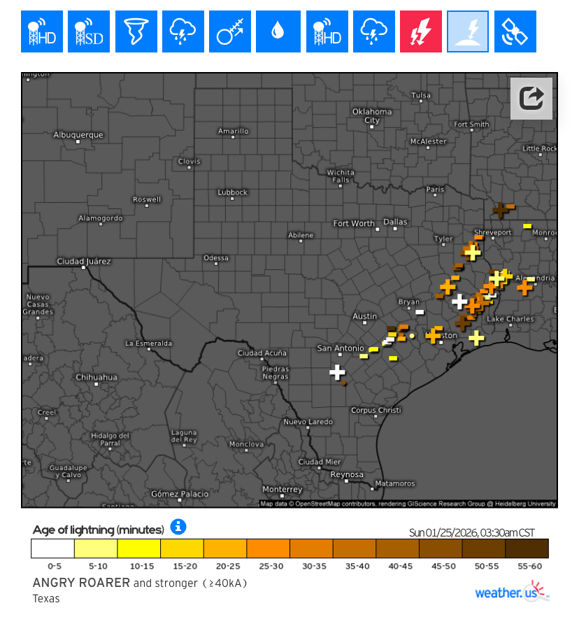
Softball hailstones (4" diameter) were reported by TX DPS Saturday evening in deep STX. Along with several other large hail & damaging wind reports to go with it in/around Rio Grande City area. Large HP supercell developed just south of Zapata and slowly moved southeast along the Rio Grande river international border and persisted for a couple hours. Then broke up into a couple of other severe-warned cells in the same area before everything diminished late night. I'm sure precip totals in that area were extremely significant with all the hail and torrential rainfall lasting for a good while.
-
Texas 2026 Discussion/Observations
Stx_Thunder replied to Stx_Thunder's topic in Central/Western States
DFW radar storm totals up near 8" just southeast of the metro. Just in the past couple hours. Still looks very convectively interesting heading into the weekend and early next week with a meandering front and cutoff Low setting up out west over Baja region. Ensembles starting to trend on a faster, but stronger/deeper track into the state. -
I would think the precip opportunity is definitely there for much of the Western and Central US for at least the next week or two, as subtropical ridging has been forecast (for over a week now) on both Euro and GFS models & ensembles to move off to the Eastern US. Which would obviously open the door aloft for more troughing to come in.
-
Texas 2026 Discussion/Observations
Stx_Thunder replied to Stx_Thunder's topic in Central/Western States
With the lack of sweeping cold fronts through early next week and subtropical ridging moving off to the Eastern US, things are already looking very interesting for a multi-day springlike (April/May type) convective pattern over the state with multiple MCSs or MCCs certainly possible. Starting later this upcoming week, to start March. Ensemble runs during the past week or so have been trending on higher rainfall amounts. Especially over CTX/NTX, up to 5 inches (even higher). Which is still way ahead of schedule for spring, just now entering March. So flash & river flooding will definitely be possible. Esp. with all the drought conditions of late. MJO is prog to head back into the latter phases with a new wave propagating through the Pacific in the coming week or so. Which will likely provide rainfall insurance. Esp. over Eastern half of state. Severe threat is bound to exist with this abnormal UL pattern setup with multiple, stronger shortwaves tracking through the state into next week. Especially near the 10th. Both Euro and GFS models & ensembles have also more or less, been keeping up on (increasing) shear values over the state. And even more persistent, steep mid-level lapse rates (7-8 C). -
MO/KS/AR/OK 2025-2026 Winter Discussion
Stx_Thunder replied to stormdragonwx's topic in Central/Western States
'Would not expect much cold over the Plains during the next few weeks. Especially, AO likely heading back into a stronger, Positive phase by the end of the month. And at least weak mid-level ridging lingering over the Plains on both GFS and Euro ensembles to start March. Though, ENSO appears to have officially begun its transition away from LN now. Late winter - early spring is typically when it starts. *May be something around mid-March. -
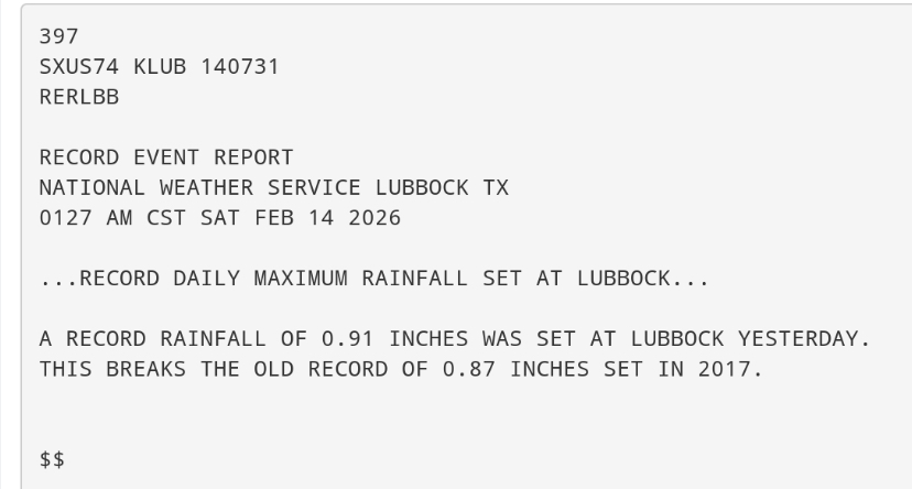
Texas 2026 Discussion/Observations
Stx_Thunder replied to Stx_Thunder's topic in Central/Western States
New maximum daily rainfall records were set at DFW and Lubbock over the weekend, also. Both (old) records are from 2017.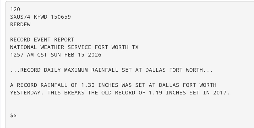
-
Texas 2026 Discussion/Observations
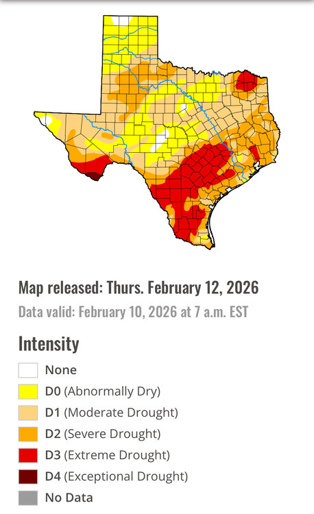
Stx_Thunder replied to Stx_Thunder's topic in Central/Western States
Decent rainfall totals with the Friday - Saturday frontal system over the state, for February (being the driest month of the year). This should make some kind of impact on the drought coverage on this week's drought monitor update (that was nearing 100% coverage over the entire state). https://droughtmonitor.unl.edu/CurrentMap/StateDroughtMonitor.aspx?TX
-
Texas 2026 Discussion/Observations
Stx_Thunder replied to Stx_Thunder's topic in Central/Western States
Looks a little interesting this evening with the ongoing severe risk and some more discrete clusters ongoing in S-SETX coastal region on the southern extent of the frontal convective line moving through ETX. Even outflow boundaries alone are producing strong gusts to 50+ mph in STX. Stronger support for lift aloft digging a bit further south in the state than usual (per Euro had projected all week) with the incoming SS trough. And this may also be an indication that ENSO has finally started its transition away from LN and hopefully toward the advertised warm/EN phase in the coming months. Which would likely make the upcoming severe season more interesting with the SS jet anchoring further south. Probably the bigger story today is rainfall amounts especially in NTX over 2" just in the past 24 hours with some flash flood alerts. Especially, considering we're currently in the driest month of the year. Very needed since over 90% of the entire state was already in some kind of ongoing drought status looking at U.S. drought monitor data on February 3rd. -
Texas 2026 Discussion/Observations
Stx_Thunder replied to Stx_Thunder's topic in Central/Western States
I can only imagine how tough it is to stay comfortably warm. Especially when it goes on for days with the cold still in place in the state all this week. I was without power for only 2 days after hurricane Harvey (2017), and even that wasn't too comfortable either without A/C. 11 K people still look to remain without power in ETX tonight. -
Texas 2026 Discussion/Observations
Stx_Thunder replied to Stx_Thunder's topic in Central/Western States
About 20K people in ETX still remain without power tonight. Since Saturday night. Namely, Shelby & Nacogdoches counties, that have been "Ground Zero" for this 2026 ETX major ice storm. The outages jumped from 30K (early this morning), back up to near 40K. But those additional 9K outages further south in Jasper county (and east) earlier today may have been unrelated.
-
Texas 2026 Discussion/Observations
Stx_Thunder replied to Stx_Thunder's topic in Central/Western States
Additional Ice & sleet damage reports in NTX/NETX, and SETX (including Houston area), finally came in from DFW and Houston NWS offices. The highest (reported) Freezing rain total in ETX was 3/4th", in Panola county. The highest NTX Sleet storm total was 5.5" in Celina, or Collin county. -
MO/KS/AR/OK 2025-2026 Winter Discussion
Stx_Thunder replied to stormdragonwx's topic in Central/Western States
10.1" of sleet was reported by an NWS met in Pulaski county, AR over the weekend. According to NWS Little Rock public information statement data on sleet reports. -
MO/KS/AR/OK 2025-2026 Winter Discussion
Stx_Thunder replied to stormdragonwx's topic in Central/Western States
'Never thought even just a 1/2 inch sleet would be enough to cause issues (like pure icing from freezing rain does at a smaller amount like 0.10" or even less). I still find sleet way more interesting than snow, in any case. And always will. Though, I have seen 2 different types of sleet. The more melted kind looks like salt flakes. While actual ice pellets are purely round, and those easily bounce off of just about anything. Which makes those kind really interesting. -
MO/KS/AR/OK 2025-2026 Winter Discussion
Stx_Thunder replied to stormdragonwx's topic in Central/Western States
Very surprised to read in here the weekend North TX Sleet storm got all the way up into AR & MO, with all the low-level WAA ahead of that major southern-stream trough (that produced a really complex winter storm event in TX). Since I've never experienced a real sleet storm, I do wonder what's the most ever sleet storm total (or depth) in this thread's states? I'm thinking it has to be at least a foot? And I wonder how that's like or driving on it. Apparently, even just 4" sleet pack is enough to get stuck from what I saw in Dallas. -
Texas 2026 Discussion/Observations
Stx_Thunder replied to Stx_Thunder's topic in Central/Western States
The main takeaways for me on this definitely complex winter storm event was the CTX/ETX major icing. But particularly the strong, wintry thunderstorms with lots of CG strikes early Sunday. Which the models surprisingly, did get right on the very abnormally high 850 Mb instability in the grids (for these shallow/overrunning Arctic airmass scenarios). That, was just pure insane. Mid-level lapse rate was maintained in the -6 to -7 range also. Which Euro advertised would be the case as well.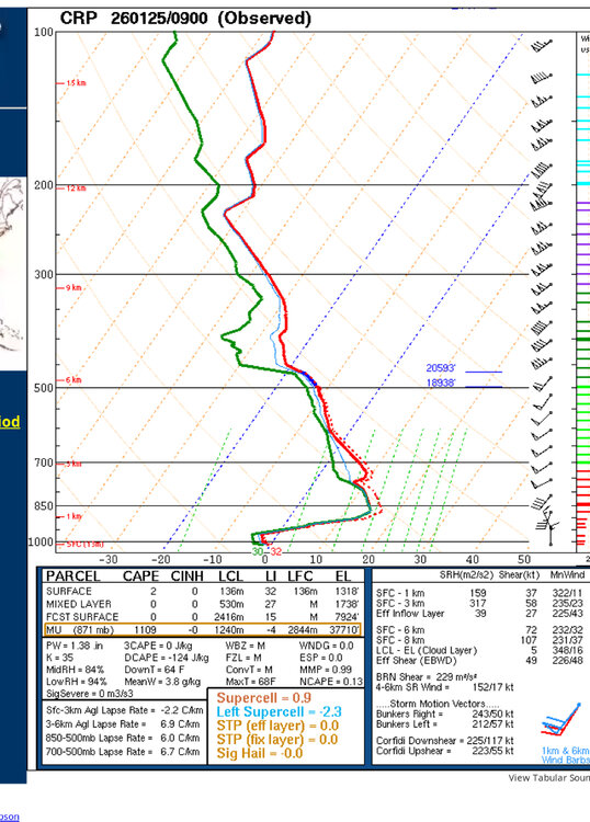
-
Texas 2026 Discussion/Observations
Stx_Thunder replied to Stx_Thunder's topic in Central/Western States
NTX/DFW Sleet pack was also nothing short of interesting. 'Still wanting to know what was the ultimate, total sleet accu. in that region. But looks like around 5 in. depth. 'Though I don't get why DFW allowed a Mavericks game to go on Saturday evening despite the major ongoing sleet storm. But I'm just guessing that's one of those 100% "Go at your own risk" type things. And I saw a live news report video last night of people getting stuck on highways in the city. -
Texas 2026 Discussion/Observations
Stx_Thunder replied to Stx_Thunder's topic in Central/Western States
Austin's Bergstrom international airport broke the record low max. temp of 33 F set back in 1961. Sunday's high (today) was 29 F. Also on yesterday the 24th, Del Rio broke the previous max. liquid-equivalent precip record of 0.35 in. set back in 2012. The new record is 0.39 in. -
Texas 2026 Discussion/Observations
Stx_Thunder replied to Stx_Thunder's topic in Central/Western States
ETX power outages have significantly dropped since early this morning. But several counties still have a significant amount of outages ongoing. A Lot of new ice and winter storm reports to sift through today, and I haven't had normal sleep the past few days. But skimming through in CTX, ETX (even SETX), this ice and winter storm event in the state was by no means a bust. Even San Antonio & Houston did not get spared either. Which the models did not forecast any major icing to happen at all that far south. -
Texas 2026 Discussion/Observations
Stx_Thunder replied to Stx_Thunder's topic in Central/Western States
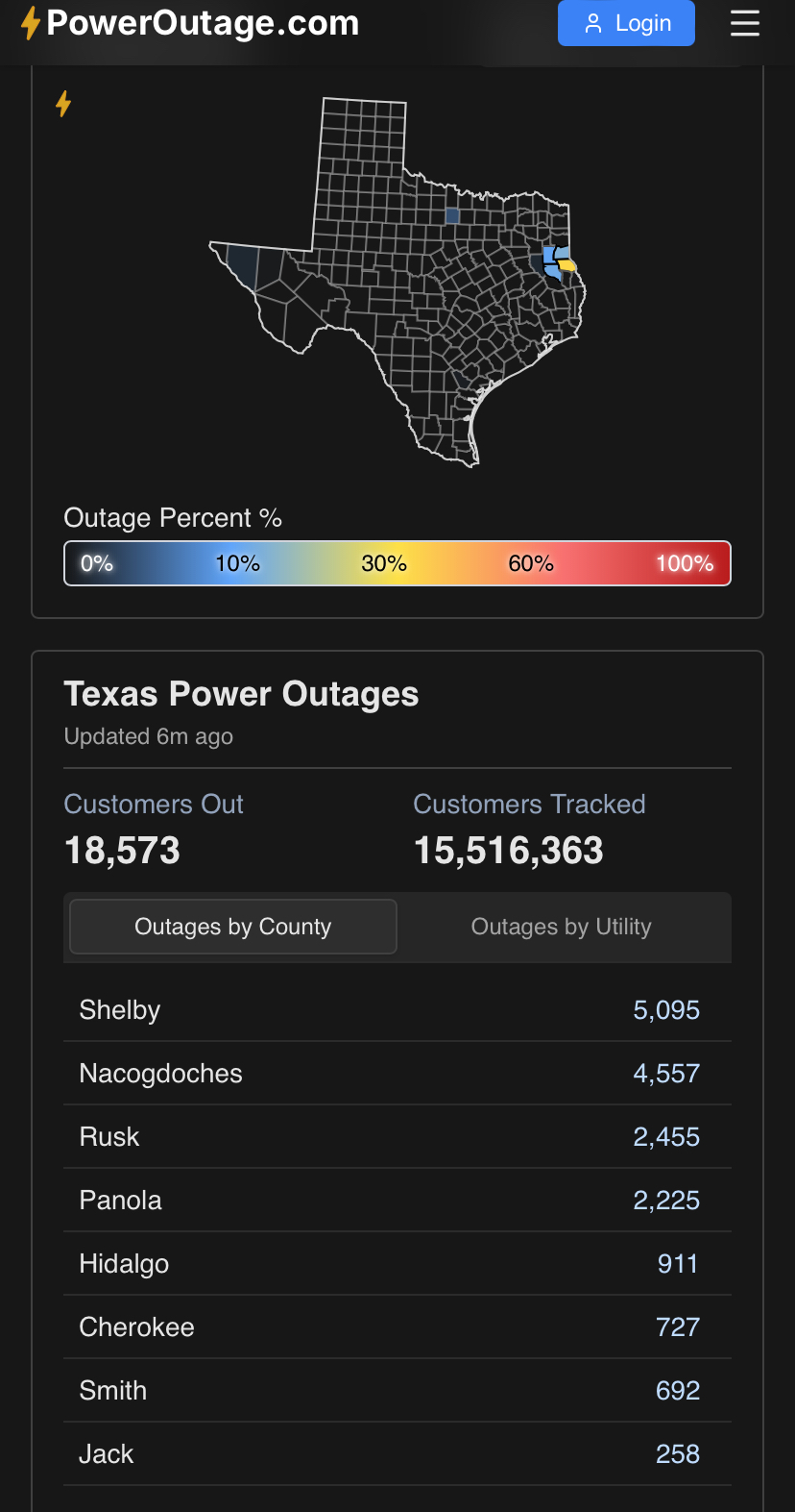
ETX power outages are growing this morning (according to Poweroutage.us data that also includes electric providers in each county). It went from 100K a little over 3 hours ago, to about 140K now. https://poweroutage.us/area/state/texas
-
Texas 2026 Discussion/Observations
Stx_Thunder replied to Stx_Thunder's topic in Central/Western States
Winter wx convective instability is really starting to pick up in ETX/SETX. This is no doubt going to push up the icing accumulations in the next few hours with much higher precip rates in the thunderstorms. Even Houston is now looking to get major convective icing. Very good amount of stronger CG strikes for this scenario. Even a decent amount of positives!!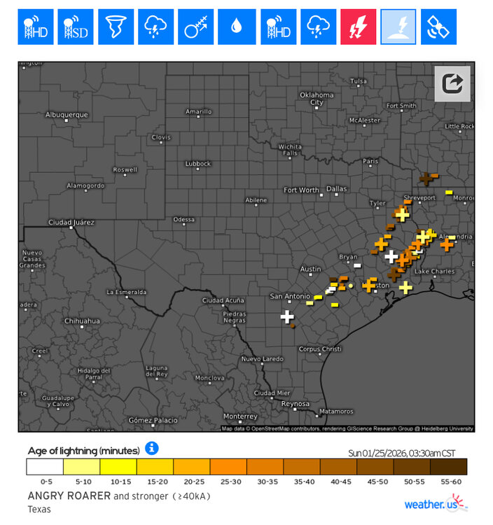
-
Texas 2026 Discussion/Observations
Stx_Thunder replied to Stx_Thunder's topic in Central/Western States
Ice damage reports are coming in now. 14,000+ people without power in SAT, so far.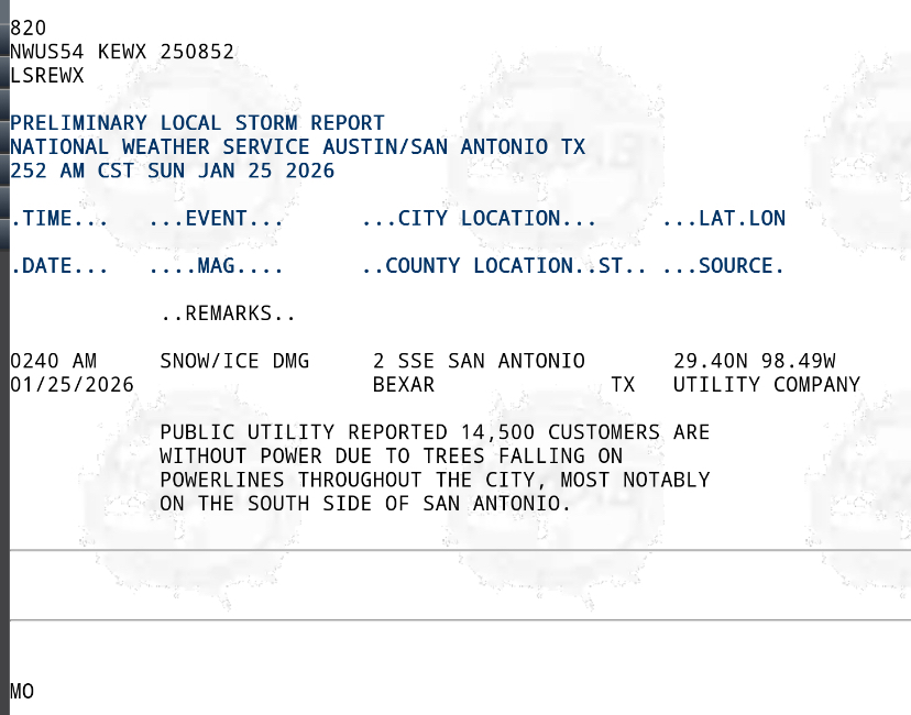
-
Texas 2026 Discussion/Observations
Stx_Thunder replied to Stx_Thunder's topic in Central/Western States
CTX/ETX ice threat continues until late tonight, at least. NAM seems to have gone way out to lunch on this evening's 0Z run with freezing rain accumulation further north in ETX. Even both Tyler & Longview have been reporting FZRA for the past two hours now, and DFW 850Mb temp is still hanging at 0 C, on 0Z upper air observations (from earlier this evening). There's a pretty solid band of precip that also has some embedded thunderstorms as well that's approaching the region as of typing this. We do also have a neutrally-tilted or N-S oriented incoming SS trough that's entering WTX now on satellite imagery. And, Houston radar VWP is showing a strengthening 850Mb - 700Mb flow that is indeed, mainly south (as the models had advertised). -
Texas 2026 Discussion/Observations
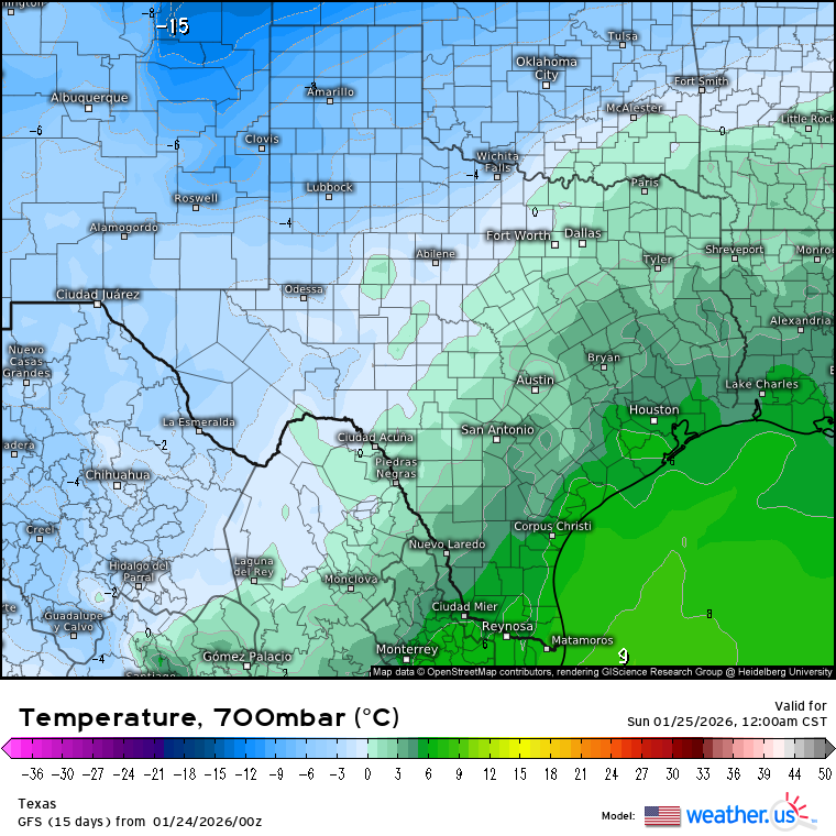
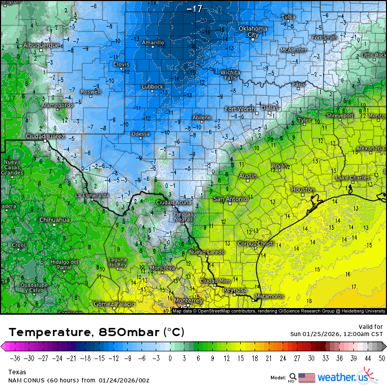
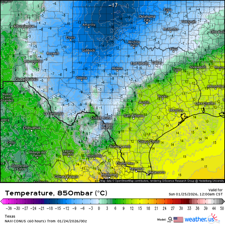
Stx_Thunder replied to Stx_Thunder's topic in Central/Western States
Posting these H7 and 850Mb temp profiles from 0Z GFS, NAM runs tonight for visual reference on why ETX icing, is bound to be majorly impactful Saturday night. As long as 850Mb - 700Mb layer warm-rain processes don't get too much in the way.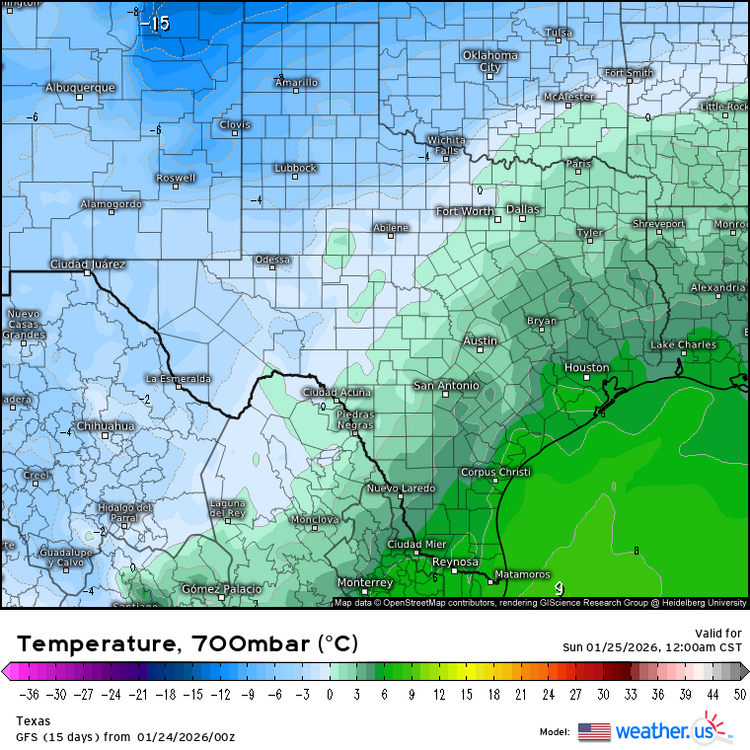
-
Texas 2026 Discussion/Observations
Stx_Thunder replied to Stx_Thunder's topic in Central/Western States
0Z GFS, NAM runs tonight appear to be coming in line with 1 - 2 in. total icing, in ETX this weekend. Either way, things are definitely still looking highly impactful there. -
Texas 2026 Discussion/Observations
Stx_Thunder replied to Stx_Thunder's topic in Central/Western States
I certainly understand there's many people out there who just want to know what's actually going to happen in weather, nothing else. And that's personally fine with me. But it's always better when people would like to (or are willing, more specifically), learn about the meteorological science & parameters in order to really understand what *can* happen. Especially nowadays where it seems like every year we pass now has its own bizarre pattern or systems that are getting more complicated to break down in meteorology.