
Stx_Thunder
-
Posts
409 -
Joined
Content Type
Profiles
Blogs
Forums
American Weather
Media Demo
Store
Gallery
Everything posted by Stx_Thunder
-

Texas 2025 Discussion/Observations
Stx_Thunder replied to Stx_Thunder's topic in Central/Western States
The trend in the more reliable models is still warmer in the LLs further north. I'm even seeing today's 12z Euro is starting to go in that direction as well up in DFW area. Which was the most pessimistic on the warming the past several days and kept showing more snow. And I agree with @Chargers09 that the models usually do underforecast the strength of these WAA patterns in TX this time of year. Particularly with these much more dynamic incoming systems out west. Either way, I'm already seeing the evidence of a stronger WAA regime on Brownsville (BRO) VWP radar right now. -
Texas 2025 Discussion/Observations
Stx_Thunder replied to Stx_Thunder's topic in Central/Western States
In winter wx forecasting, a +3 C LL layer can actually make a big difference in precip type at the surface. Even if it's below freezing at surface. Today's 12z GFS has actually come in a little warmer at 850Mb around DFW because of the projected deep, large scale south-southeasterly over the eastern half of state (keyword: southeasterly) WAA flow until it cuts off Thursday night. Showing even above 0 C spots now creeping into DFW. It's already been quite consistent on that the past several days on the 0 C area hovering over the area. So I'm confident it is not going to be all snow, daytime Thursday at least in DFW metro - southeast. 0z UA obs this evening even shows 850Mb temp is already right next to 0 C. And above freezing now north of Houston (3 C red dashed line). The LL warm-air advection regime has already started here in STX as I'm already seeing a fairly strong southeast flow near 30 knots at 5 Kft on Brownsville VWP radar right now.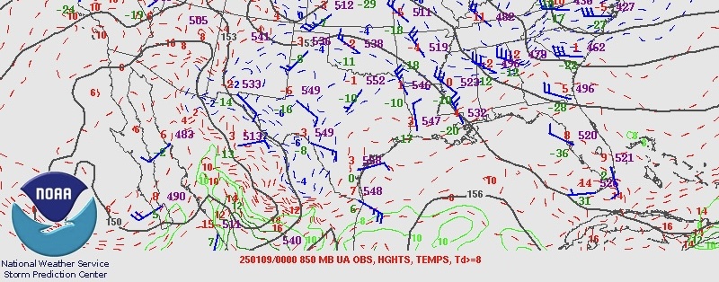
-
Texas 2025 Discussion/Observations
Stx_Thunder replied to Stx_Thunder's topic in Central/Western States
Not seeing any real thermal differences and I trust the 12z runs more from experience. 850Mb 0 C line is still way too close over DFW for all-snow comfort until later Thursday night. Should also note 700Mb 0 C line also still quite close on both runs as well. -
Texas 2025 Discussion/Observations
Stx_Thunder replied to Stx_Thunder's topic in Central/Western States
Both today's 12z GFS & Euro trending on a slower approach of the H5 Low out west and consistently still quite potent & large. This could easily allow for longer/deeper low-level WAA over the eastern part of state as the Gulf Low is likely to track more northward up the coast instead of offshore. With a fairly strong southerly LLJ (possibly 50 knots in STX which is definitely plausible in this scenario but could be even stronger as I've seen in past years, this time of year). While not likely, it's definitely worth noting Canadian wants to bring the 850Mb Gulf circulation further inland over ETX Thursday night on today's 12z run. WPC now even has a marginal excessive rainfall risk posted for mid-upper coast for possible 3 - 5 in. rain totals Thursday - Friday morning (Day 3). Which would 100% be above normal for this time of year in such short duration. --- 850Mb temp even now on DFW 0z UA obs this evening is only around -2 C (-3 this morning) per SPC data with above freezing values not well south either. All in all, it's pretty safe to say now it will not be an all-snow event in DFW. Moisture should not be an issue around there in this scenario with the large-scale and fairly deep WAA regime over the eastern part of state. And it's definitely keeping my eyes pinned on that up north way more than the coastal & possibly even up to ETX heavy rainfall threat (again there) around me. Even thunder potential over all coastal region which SPC noting on D3 outlook. Which I wouldn't rule out a supercell or two near the upper coast with 60s DPs coming right next to the coast (even upper 60s not far offshore) on both GFS & Euro, with such a very dynamic system out west. Which I still don't think many here realize. -
MO/KS/AR/OK 2024-2025 Winter Discussion
Stx_Thunder replied to JoMo's topic in Central/Western States
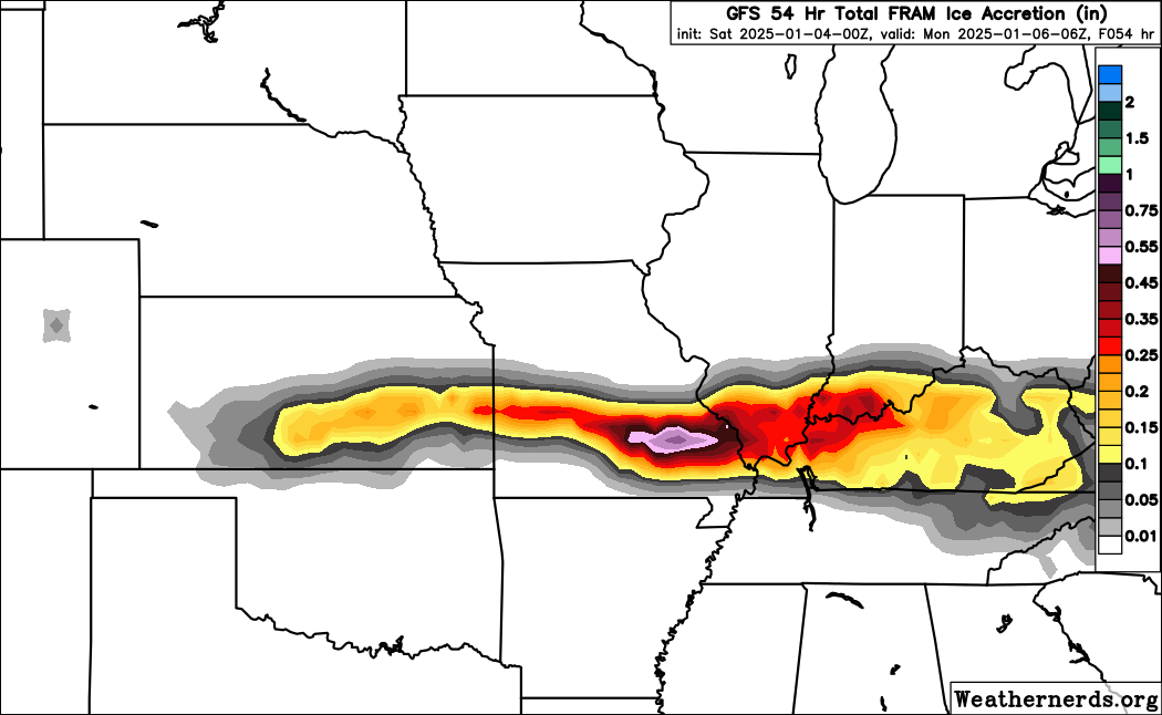
Saw FZRA icing accumulation this past weekend was actually 0.50 - 0.75 inches in southeastern MO (St Louis NWS) storm report near Chloride. Just like the GFS painted there last week. A 2.5" Sleet LSR somewhere in that region as well, but there was snow mixed in many of those sleet reports. Things are trending less snow and potentially more icing over Eastern TX because of projected warmer LLs, but possibly a dismal rain only. Even in the Dallas-Fort Worth area. -
Texas 2025 Discussion/Observations
Stx_Thunder replied to Stx_Thunder's topic in Central/Western States
That'd be very interesting as well like I kind of got here back in 2021 TX chill. 'Wasn't an actual sleet storm around here in STX, but still lasted a couple hours & the most I had ever seen from my own eyes. I've already seen all snow a couple times and in other places out there. Freezing rain with icing accu. only once. All of which are pretty rare down here. It would be even more interesting if all winter precip types actually happen in DFW this time around. Which there is that possibility in the cards as well. -
Texas 2025 Discussion/Observations
Stx_Thunder replied to Stx_Thunder's topic in Central/Western States
With the projected southeast LL flow on all the main globals all the way north to DFW, there is definitely that chance it could end up being mostly rain (which I kind of hope not and gets a good icing event at least), with such sig Gulf-influenced WAA pattern. Maybe not initially because of dry/cool LL environment at first, but the warm-rain processes would eventually force it to go all non-freezing rain if much of the lower column does go above freezing. It's a pretty complex winter wx forecasting scenario this time around which makes this a heck of a lot of more interesting to watch around DFW this week. It's very important to note though, that more southeasterly LL flow (instead of southwest). I haven't seen a winter wx scenario like this in NTX with that kind of flow from what I've seen over the years. If it was more southwest (like I'm sure it is most of the time up there in winter wx scenarios), then all the NTX or DFW area snow addicts on here would likely be jumping by now.. -
At this point in DFW and south into C/ETX seeing all the newest data output today, it's looking more like a messy (interesting) all types winter precip setup later this week. H5 temps may be cold enough for all snow in NTX with the incoming SS Low out west. But I've been seeing the globals (including Euro) being fairly consistent the last couple days on 850Mb and even H7 temps, merely staying around 0 C (if not potentially warmer) for most of the active period with such an unusually broad Gulf low influencing a fairly deep southeasterly LL flow over the Eastern half of state. Which would likely cause some sig LL warming even into DFW area at least to an extent.
-
MO/KS/AR/OK 2024-2025 Winter Discussion
Stx_Thunder replied to JoMo's topic in Central/Western States
Posting some actual FZRA ice accumulation output here (that's not liquid-equivalent), for this weekend's event. Especially over southeastern MO. NAM isn't far behind also.
-
Texas 2024 Discussion/Observations
Stx_Thunder replied to Stx_Thunder's topic in Central/Western States
Actually, GFS wasn't going very cold and didn't start blowing winter precip up over the state until a couple days ago. Euro's actually been more consistent overall since around or just after Christmas with this likely winter cold outbreak next week. The much colder air intrusion is pretty much a certainty now. Especially because of the already strengthening ongoing -AO phase. But the winter precip potential across TX is still more like 50/50 as things stand today looking at all the model data over the last several days as well. Which is also harder to project than colder temps. Especially still being a week away FYI. I haven't read their AFD today but the likely reason Dallas/Fort Worth NWS office is keeping the better precip south of their CWA is because the stronger continental airmass intrusion or deeper northerly L-ML flow in NTX could dry out the column more than to support any real precip around there when the energy from the advertised SS Low out west later next week takes shape. The Euro ensemble system (EPS) is starting to show this over DFW area in today's 12z run. GEFS also isn't showing much either over NTX. -
MO/KS/AR/OK 2024-2025 Winter Discussion
Stx_Thunder replied to JoMo's topic in Central/Western States
Very interesting FZRA accumulation projection. Especially seeing that maximum 1.38 in. accumulation potential over MO which would definitely be extreme icing, no doubt. Though I'm sure Euro is overdoing that (as it tends to with precip/convective forecasting to an extent but nevertheless). -
Texas 2024 Discussion/Observations
Stx_Thunder replied to Stx_Thunder's topic in Central/Western States
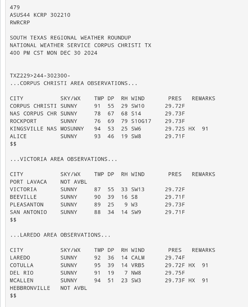
To note, the most notable heat spike record highs over the southern part of state on December 30th are: San Antonio at 89 F (previous 83 F in 1951) McAllen at 94 F (previous 89 F in 1945) Victoria at 87 F (previous 82 F in 1973) Fairly extreme records to end 2024. -
Texas 2024 Discussion/Observations
Stx_Thunder replied to Stx_Thunder's topic in Central/Western States
More 90s starting to show up over STX this afternoon than forecast. Especially closer to the Rio Grande/Laredo area. There's a dryline moving into the region with southwest - west surface flow and dropping DPs on obs. So looks like a good amount of records are going to be broken today across the region. Even San Antonio is next to 90 F now which I'm sure is already in record territory.
-
Texas 2024 Discussion/Observations
Stx_Thunder replied to Stx_Thunder's topic in Central/Western States
Before winter starts returning to the state going into the new year, McAllen reached & set a new record high of 91 F yesterday. Which even there by December is well above normal (about 20 degrees). Previous record, 89 F in 2016. The potential is definitely there for another record-breaking heat spike into the 90s in deep STX tomorrow ahead of the first in a series of winter-returning cold fronts. NBM output from what I was reading on Brownsville AFD this afternoon going as high as 95 F. Which definitely is not out of the realm of possibility in the McAllen/Rio Grande City area considering GFS showing 850mb temps > 20 C and a typical south-southwesterly pre-frontal LL flow. -
MO/KS/AR/OK 2024-2025 Winter Discussion
Stx_Thunder replied to JoMo's topic in Central/Western States
That's what happens when you anticipate snow and tornadoes on here way too much lol Still, I just hope this S Plains Arctic airmass outbreak actually verifies to start 2025, and for all of TX especially considering how warm the winter has been so far. Although, hasn't been terribly warm down here since December started. The more sig -AO phase projection makes the potential outbreak and how far south it penetrates 100% worth watching even down here going into the new year. -
Texas 2024 Discussion/Observations
Stx_Thunder replied to Stx_Thunder's topic in Central/Western States
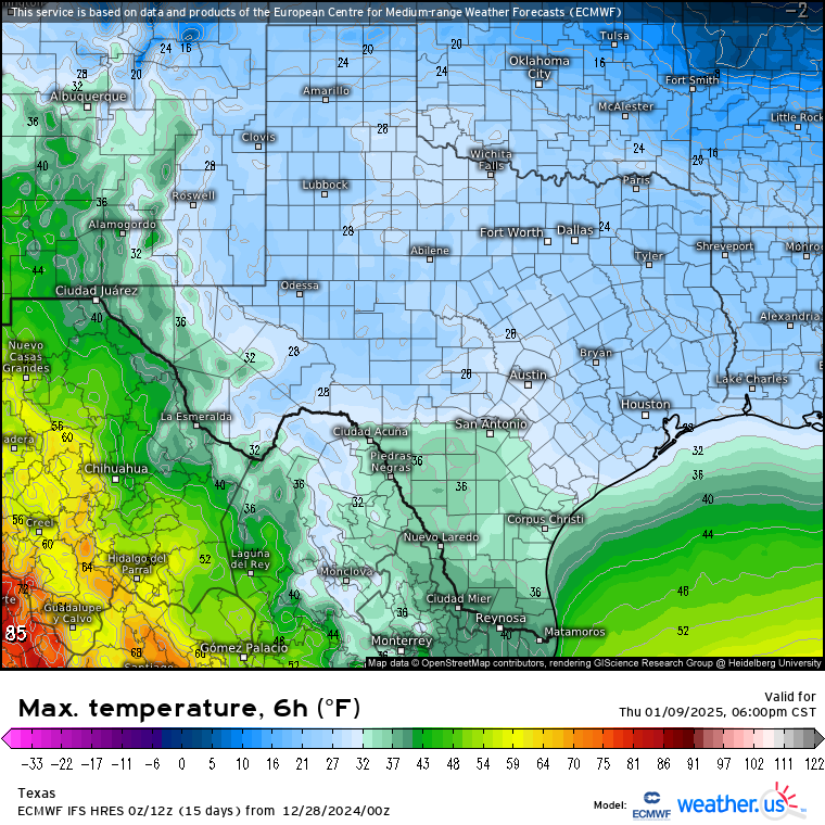
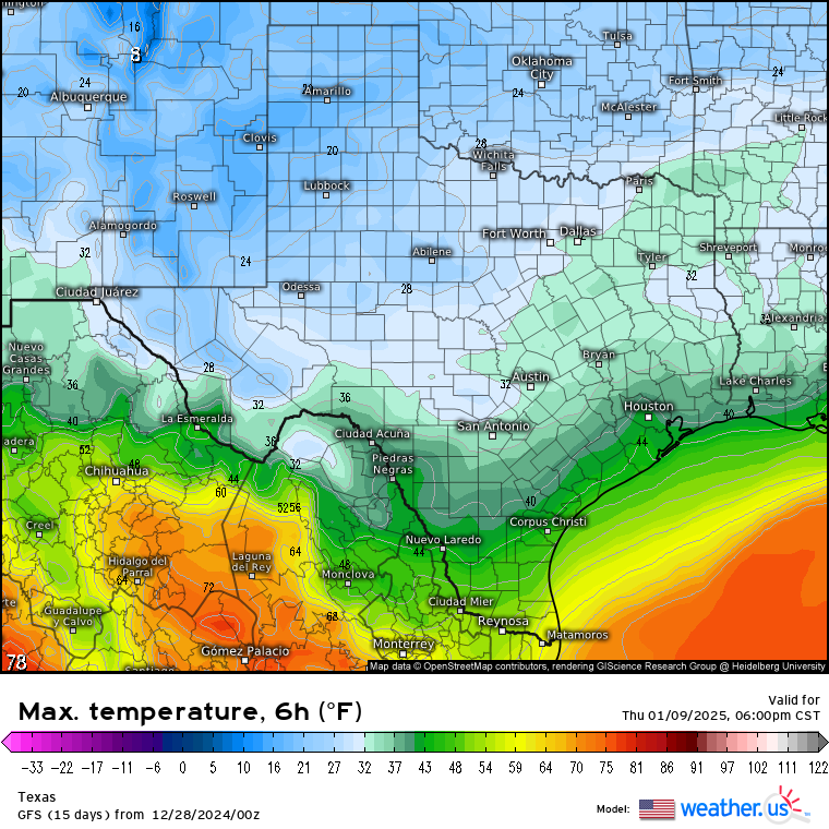
Looking ahead into 2025 (before new years celebrating comes), just saw the latest 0Z Euro and GFS runs on projected temps after Jan 5th across the state. Ensembles not going as cold at this point, but CFS is also trending colder in the state as well in the last few runs. And, AO is forecast to go back negative (possibly significant phase) in the beginning of January. Am more surprised Euro is going colder than GFS here. Which usually isn't the case this far out.

-
Texas 2024 Discussion/Observations
Stx_Thunder replied to Stx_Thunder's topic in Central/Western States
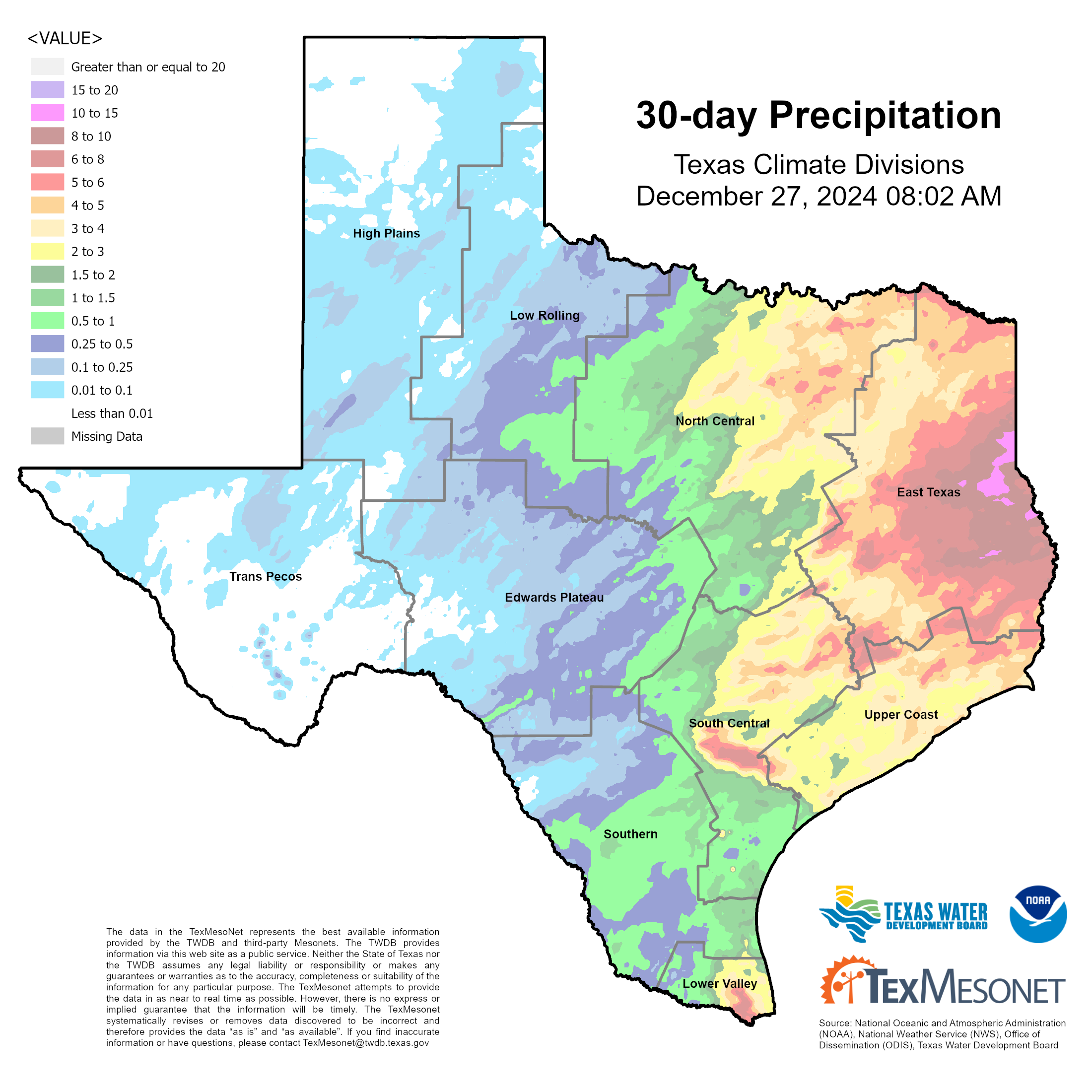
Saw significant areas of 2 - 3 in. for yesterday's storm totals over ETX. That now brings accumulated rain totals actually up to and even over 10" in a couple spots over far ETX since the last few days of November. Which is well above normal now for this month in December there no matter how you look it at it. I also looked at some average monthly rainfall climatology map data for December to verify. This has basically become a repeat of the late spring ETX waterlogging earlier this year. Also, HGX radar estimated about 5 in. area yesterday with the stronger cells not far east of Houston, near Beaumont. Victoria area also got lambasted with several inches of rainfall in just a few hours from the Christmas Eve night thunder system (flash flood warnings obviously issued there that night going into Christmas morning). This looks to be it for major convective events for the rest of 2024. Winter looks to return to the whole state by the very start of 2025. Which will be nice with all things considered of late.
-
Texas 2024 Discussion/Observations
Stx_Thunder replied to Stx_Thunder's topic in Central/Western States
Still looks more like a heavy rainfall/flash flood threat. Rather than severe threat over E/SETX later today (26th). The globals have also backed off more on the amount of substantial inland CAPE penetration from a few days ago on runs. Except around Houston area (near coast). The Gulf warm sector or old Christmas Eve front that caused all the robust storms last night doesn't look like it'll move back far enough north to really bring back convective instability looking at dew point projections also (like the environment already was Christmas Eve). Precipitable water is projected to get close to 2 in. on both Euro & GFS (near 1.8" now on GFS). Which is actually a good ways above normal for this time of year, being wintertime especially. So I definitely agree with WPC's excessive rainfall outlook slight risk area over a larger area of ETX. Maybe even DFW area. If it's another potent shortwave coming in like the Christmas Eve one, it might border on moderate risk level in some areas over E/SETX. Especially with such above normal PWs being projected and all accumulated rainfall around there since December began. Some areas have seen 5 in. (bit higher in some spots looking at TexMesonet data), just in the past 2 weeks. I'm sure that's fairly high for December standards even for that region. -
Texas 2024 Discussion/Observations
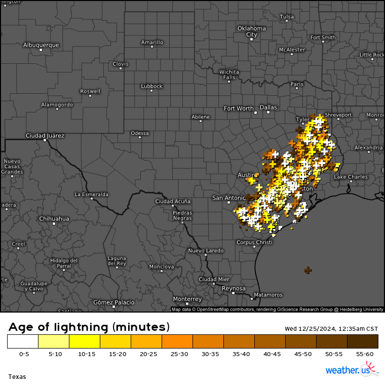
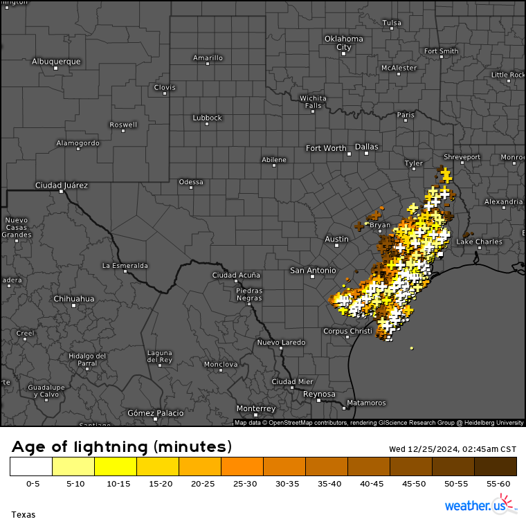
Stx_Thunder replied to Stx_Thunder's topic in Central/Western States
Robust convective environment around the I-10 corridor region for Christmas tonight, alright. Definitely looks like an early/mid spring convective pattern or MCS. +CGs really went on from around midnight until about an hour ago. - Should also note that the ML temp profile aloft is pretty cold as H7 temps were only 4 C in STX, and closer to -20 C further north @ H5 on yesterday evening's obs sounding data.

-
Texas 2024 Discussion/Observations
Stx_Thunder replied to Stx_Thunder's topic in Central/Western States
Some real (sfc-based) Christmas thunder action going on around the I-10 corridor SC - SETX region this evening. Roughly between San Antonio - Houston now. Radar showed a few convective tops getting close to 50 Kft in the past 2 hours near SAT on the southern most cells. Quite high for this time of year. Decent amount of severe hail reports in the past several hours of > 1 in., and a large hail (2 in.) report near Caldwell. -
Texas 2024 Discussion/Observations
Stx_Thunder replied to Stx_Thunder's topic in Central/Western States
With all this above normal Gulf warmth next to Christmas, not surprised SPC is possibly under-doing things (again) later today on Christmas Eve with just a marginal risk area on this early morning's D1 outlook. Both Euro & GFS are actually showing a pretty volatile convective environment around the I-10 corridor (SAT - HOU areas) with the next front moving through the state. I also saw an isolated storm not far offshore yesterday afternoon that lasted for a while on its own when I was out and about. DL shear doesn't look to be really strong, but still notable areas of 40 - 50 knots by early evening in San Antonio region. Multi-global model output also showing near 100% thunder risk areas. And this time moreover, ML lapse rates look to be pretty steep (closer to 8 or even possibly above). Potential steep LL lapse rates also as the front will be coming into the region at best time of day (later afternoon). - At this point on model runs, Thursday's (26th) setup isn't looking anywhere as convectively unstable in E/SETX. Despite better projected shear. -
Texas 2024 Discussion/Observations
Stx_Thunder replied to Stx_Thunder's topic in Central/Western States
Overrunning cold rain & elevated thunder setup this weekend looks good for much of the state. The best statewide rain setup even out west in the more drought-stricken areas of the Western hill country and San Antonio region (since start of Nov). Likely no drought buster around there with this kind of winter setup, but is definitely a step in the right direction. Euro and GFS have been showing up near an inch or so in some areas out there through early next week in the past several runs. Higher totals will obviously be further east per usual closer to the coastal surface Low/warm front moving near the coast in response to the incoming ML Low out west. Seeing that next cutoff incoming ML Low starting to take shape this evening near the AZ/Mex border and appears to be deepening. Which could cause it to dive further south in Mex before it ejects this weekend. Either way, models have been showing plentiful support for lift aloft during the past couple days of runs along with saturated low-mid levels. ML lapse rates are already fairly steep this evening around the state. Already seeing some high-based sporadic lightning activity going on this evening over WTX. - - - Saw there was some fairly frequent lightning discharges and elevated thunder clustering scenario in yesterday's SS shortwave energy over C - ETX. Some powerful CG strikes yesterday around midday (>100 kA) on the map in such overrunning pattern. Wednesday 12Z DFW ua obs only had about 500 MUCAPE (if that) with definitely not the steepest of ML lapse rates (only about 6 but did go above 7 late in the day) either to really support that kind of frequent lightning discharge. Though some of those convective tops yesterday did manage near 40 Kft looking at ET radar data. -
Texas 2024 Discussion/Observations
Stx_Thunder replied to Stx_Thunder's topic in Central/Western States
'Loving this very comfortable polar airmass intrusion and overrunning pattern ongoing around here (1st real one of the season) that looks to stay in place until the middle of next week. Gotta be thankful for that and came in early yesterday on the holiday also (as it should more often this time of year). Decent, but typical net result coastal troughing looks to deepen next to Deep STX the next few days, so overrunning rainfall and even some thunder potential is there for the entire Coastal region. Euro, has been putting out some decent amounts for the time of year & scenario (and all things considered lately with the basically statewide drought now also). Up to a couple inches total over SETX into next weekend, but may be overdone and because of the time of year. GFS going somewhat drier, but is showing hints of the coldest wx of the season over the state (so far) going into the 1st full week of December. Which wouldn't be surprising now as I'm also seeing a trend in the GEFS painting a more persistent - AO phase going into mid-December. Which could lead to a more prolonged chill period also. That'd be quite a turnaround before the end of the year, from all the warmth of late. -
Texas 2024 Discussion/Observations
Stx_Thunder replied to Stx_Thunder's topic in Central/Western States
Looks a bit interesting tonight near/just west of DFW area, and possibly Coastal/SETX Monday afternoon with the front from that next incoming deep but compact ML Low out west. Tracking even further south over northern Mex on wv right now. CAPE and ML lapse rates (again) are going to be the negating factors. And Fall, actually coming in this week with a reinforcing polar surge dropping all the way through the state mid-week. 40s F everywhere (including STX) Thursday morning on both GFS & Euro. Euro showing DPs in the 10s over CTX Wednesday afternoon (fairly impressive for the time of year). -
Texas 2024 Discussion/Observations
Stx_Thunder replied to Stx_Thunder's topic in Central/Western States
No outbreak by any means yesterday, but was not a bust in the state either. - And I have to give GEFS and EPS systems actual credit for the preliminary projection & track of yesterday's deep ML Low into NM and panhandle, from Oct 20th - 25th. They were basically trash for when summer started this year, but this is a pretty good make up. Especially coming out of a unusually quiet October.