
Stx_Thunder
-
Posts
409 -
Joined
Content Type
Profiles
Blogs
Forums
American Weather
Media Demo
Store
Gallery
Everything posted by Stx_Thunder
-

Texas 2026 Discussion/Observations
Stx_Thunder replied to Stx_Thunder's topic in Central/Western States
I certainly understand there's many people out there who just want to know what's actually going to happen in weather, nothing else. And that's personally fine with me. But it's always better when people would like to (or are willing, more specifically), learn about the meteorological science & parameters in order to really understand what *can* happen. Especially nowadays where it seems like every year we pass now has its own bizarre pattern or systems that are getting more complicated to break down in meteorology. -
Texas 2026 Discussion/Observations
Stx_Thunder replied to Stx_Thunder's topic in Central/Western States
The primary forcing aloft from the parent mid-level trough out west isn't forecast by the reliable models to start overspreading the state until later today - tonight. Which is why I've been stating the main deal (especially for convective ice/sleet) is going to be Saturday night. It's common to have "lull" or large gap areas of little or no precip between lead shortwave activity like what's ongoing in the state tonight. I have not seen the RRFS in action at all for winter wx events yet. But it does have its moments for MCS (mesoscale convective system) propagation through the state in the spring time. -
Texas 2026 Discussion/Observations
Stx_Thunder replied to Stx_Thunder's topic in Central/Western States
Already seeing lightning activity ongoing over the Big Bend region (west of Del Rio) for the past 2 hours now. 12Z HRRR showing an MCC or small MCS tracking into STX ahead of the surface front later tonight. Which definitely has the possibility to be strong/severe if the storms out there can organize. Already seeing some favorable signs outside here in STX with all the darker mid-level cloud bases and structures before sunset. -- I do need to mention another highly underlooked instability parameter that will in fact be another major contributing factor to the wintry convective onslaught tomorrow (aside from substantial deep-layer shear closer to 100 knots on Euro & NAM), is steep mid-level lapse rates. CRP and HOU sites showing -6 to -7 C on upper-air obs data today. And Euro model systems continue to project those in the state through tomorrow night. -
Texas 2026 Discussion/Observations
Stx_Thunder replied to Stx_Thunder's topic in Central/Western States
Was there also CG lightning going on up there back then that night? It was just incredible when I saw 2 simultaneous CG strikes (likely positive-charged because they were pretty thick bolts), in just over 35 F wx about a mile from my backyard down here. I didn't have access to detailed lightning strike data online back then. -
Texas 2026 Discussion/Observations
Stx_Thunder replied to Stx_Thunder's topic in Central/Western States
Yes. Very, significant LIs for this kind of scenario. Just about every single parameter I can think of is lined up for a (possibly) catastrophic ETX ice storm. I don't want to overstate myself, but I feel even these most reliable winter wx models are still underdoing the accumulation potential with such a powerful incoming SS trough for this winter wx setup. That's also why I still would not let my guard down at all. Even in CTX or Austin/San Antonio region. -
Texas 2026 Discussion/Observations
Stx_Thunder replied to Stx_Thunder's topic in Central/Western States
Same here, definitely. HRRR does tend to overdo things. Particularly when it's convective, as I've seen over the years. But even NAM, which is typically very conservative with any kind of overrunning convective instability (especially in these polar/arctic air masses), has joined that party. It's even been showing significant 850Mb instability (negative LIs) over ETX in more recent runs for Saturday night.
-
Texas 2026 Discussion/Observations
Stx_Thunder replied to Stx_Thunder's topic in Central/Western States
'Would not necessarily underestimate FZRA accumulation potential, even up there. Models have been honing in on a pretty powerful incoming SS trough out west into the state Saturday night. So the 850Mb - 700Mb southerly flow regime from S - ETX is quite likely to be significant. Even the NAM 3km runs (which always does best with these incoming shallow Arctic airmass scenarios), has been consistent on showing the 850Mb front still hung up close to DFW until late Saturday night. Which makes lots of sense in this case. -
Texas 2026 Discussion/Observations
Stx_Thunder replied to Stx_Thunder's topic in Central/Western States
Finally... NWS got smart in ETX. I'm actually a bit surprised they went ahead and put out the IS warnings now. Since they initially just went with WS alerts. -
Texas 2026 Discussion/Observations
Stx_Thunder replied to Stx_Thunder's topic in Central/Western States
Icing potential is definitely still there in Austin this weekend, and even San Antonio area at least to an extent. I have family in Austin region and would definitely still tell them to be prepared nonetheless (even though the much more significant or damaging ice impacts are likely to remain in ETX). NAM, alongside GFS models typically do best at least with ice/sleet accumulations in the state from what I've seen in past years. European (ECMWF) model isn't as reliable with accumulations in TX as it tends to stay too warm on surface temps.
-
Texas 2026 Discussion/Observations
Stx_Thunder replied to Stx_Thunder's topic in Central/Western States
'Hope ETX people are prepped by early tomorrow! Only thing I'm seeing now that could potentially interfere major icing or FZRA accumulation is the warm-rain processes from all the WAA occurring in the 850Mb - 700Mb layer Saturday night ahead of the SS trough. But below 850Mb - sfc is looking cold enough by later in the night to prevent that for most of the region. -
Texas 2026 Discussion/Observations
Stx_Thunder replied to Stx_Thunder's topic in Central/Western States
Elevated wintry thunderstorms are looking pretty likely now in ETX (where it's most probable to occur), with lots of 850Mb - 700Mb WAA there. Euro is even showing unusually decent 850Mb instability from around Tyler area and south Saturday night. With lifted-index values down to -3. Definitely would not rule out a sig amount of CG lightning with those kind of instability values. Quite unstable and abnormal with this Arctic airmass setup. This is looking to be similar to the post-frontal Arctic airmass convective event in the state back in March 2014. Where even though sfc temps were above freezing in the 30s, I still had some pretty strong storms in STX with substantial CG lightning activity that one night. Which I had never experienced before. -
Texas 2026 Discussion/Observations
Stx_Thunder replied to Stx_Thunder's topic in Central/Western States
0Z NAM was showing at least close to 1" icing in ETX. GFS was going all the way up to 2". Even just 1 inch icing is more than enough to cause major impacts & power outages. -
Texas 2026 Discussion/Observations
Stx_Thunder replied to Stx_Thunder's topic in Central/Western States
ETX icing threat is looking real now with an R. I feel that an Ice Storm watch/warning is easily warranted now (rather than a Winter wx one in this region), as the incoming SS mid-level trough out west is trending more intense and diving abnormally further south into MX than I had suspected. Even on NAM, the H5 trough axis taking on at least a neutral (N-S) tilt. Which will definitely strengthen the mostly south flow WAA regime over ETX ahead of it (possibly up to 60 knots), in the 850Mb - 700Mb layer. Which is most critical for precip type. Even in STX, would not rule out at least a few elevated supercell storms with so much incoming dynamics aloft Saturday night (behind the surface front). But even in ETX, thunder ice/sleet is looking very likely now at least in a scattered storm variety. -
Texas 2026 Discussion/Observations
Stx_Thunder replied to Stx_Thunder's topic in Central/Western States
'Surprised to see SPC already mentioning the wintry thunder potential in their current D3 outlook this morning (not usually the case that far out). Which will only jump up the icing accumulation in ETX where it'd be most likely. -
Texas 2026 Discussion/Observations
Stx_Thunder replied to Stx_Thunder's topic in Central/Western States
FZRA potential is likely going to be limited, if anything over the coastal region (as is typically the case). But that C/ETX ice storm potential (even thunder ice/sleet) is looking real. Seeing all the parameters tonight on both Euro & GFS. Gonna be extremely interesting to watch this weekend. 'Pretty deep incoming SS trough in the state with lots of mid-level energy overspreading the northern half, at least. H7 temps mostly => 0 C is the prime factor that's bound to keep this from being a snow event over the Eastern half of state. Even H5 temps aren't looking cold enough either ahead of the trough (not even close to -20 C). Which I'm very sure is still a by-product of all the highly abnormal ML ridging over the IW and Plains states back in December. -
Texas 2026 Discussion/Observations
Stx_Thunder replied to Stx_Thunder's topic in Central/Western States
Looks to be a big change in the ongoing winter season pattern this weekend/early next week. Considering all the recent abnormal December and especially Christmas week winter heat in 2025. 'Doesn't look like any extreme cold to worry about as ensembles are not gung ho at all on an Arctic airmass plunge into the state or even the surface High and its strength. Even though the AO is going deeper into a negative phase, the AAO (Antarctic Oscillation) remains in positive phase. The MJO has reemerged into the favorable latter phases (6 - 8) and looks to remain there the next few weeks at least. So precip odds for the state should get better going forward, and could make some frozen precip over the eastern half of state a distinct possibility this weekend. The PNA should remain in a positive phase as well. -
Texas 2025 Discussion/Observations
Stx_Thunder replied to Stx_Thunder's topic in Central/Western States
2025 is over folks. I had already started a 2026 thread for that exact reason (back on New Years Day) here: https://www.americanwx.com/bb/topic/62492-texas-2026-discussionobservations/ So I don't know why posts are still being made in here. And I've sent a request to lock this 2025 thread (rather than just delete it). -
Texas 2026 Discussion/Observations
Stx_Thunder replied to Stx_Thunder's topic in Central/Western States
Brownsville got into the 90s today, and broke the record of 91 F set back in 1982. -
MO/KS/AR/OK 2025-2026 Winter Discussion
Stx_Thunder replied to stormdragonwx's topic in Central/Western States
Some maximum temp records could be in jeopardy again this upcoming week as ridging aloft looks to reassert itself over the Plains states early in the week. -
Texas 2026 Discussion/Observations
Stx_Thunder replied to Stx_Thunder's topic in Central/Western States
Several cities in the eastern half of state broke daytime high temp records today. Due to the dryline reaching all the way east into ETX. A deeper westerly downslope flow was found even in College Station and Tyler in the afternoon. Aside from the tied all-time January temp maximums in both Austin and San Antonio, the biggest jump in maximum daytime high from previous record for today (January 2), was actually in Waco.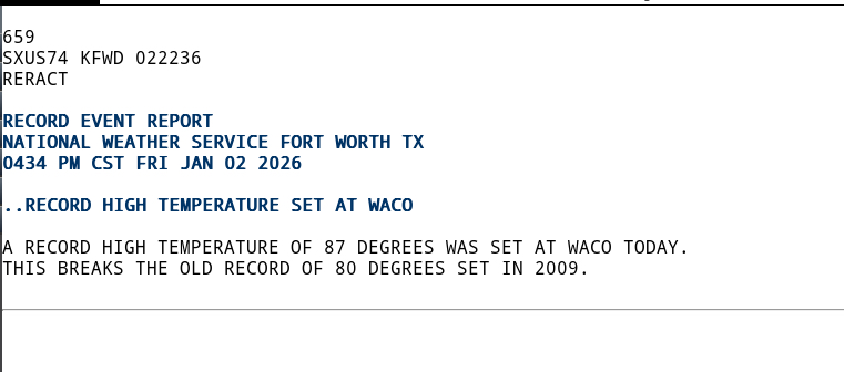
-
A new year? A new TX thread. - Looking pretty warm with more widespread sig ridging influence across the central states (again), to start 2026. Euro and ensemble already going up to 20 C on 850Mb temps ('plain & simple' way above normal this time of year) in some spots the next several days. Which that alone leaves me with almost 0 doubt, more sfc temp records are going to be broken across much of the state, once again. Along with even dryline influence invading the state as well from the west (more indicative of an early springlike zonal flow pattern). Which will only add more daytime high record-breaking fuel potential to this second (virtually inevitable now) winter heat wave. "Winter's over, ya'll!"
-
Texas 2025 Discussion/Observations
Stx_Thunder replied to Stx_Thunder's topic in Central/Western States
Why am I not too surprised about completely uncalled for "mistakes" like this from NWS anymore..: The nut "forecaster" who posted that must've been on 'you know what'. Possibly even more so when they learned the Christmas in July pattern would be in the grids this year.
-
MO/KS/AR/OK 2025-2026 Winter Discussion
Stx_Thunder replied to stormdragonwx's topic in Central/Western States
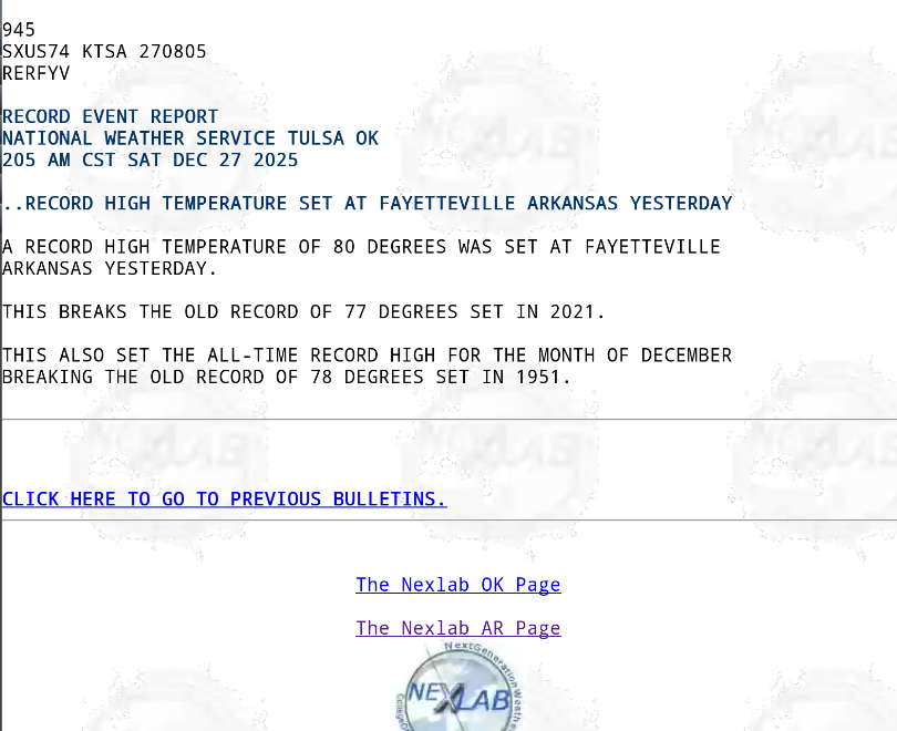
Not before setting a new all-time, daytime high record for December this year (that I posted about in here). Very interesting as that had not happened in Fayetteville AR since back in 1951. -
Texas 2025 Discussion/Observations
Stx_Thunder replied to Stx_Thunder's topic in Central/Western States
Almost every part of the state now has either or both, broken a max daytime or overnight high minimum temp record this week. Amarillo & El Paso are also included looking at Nexlab data. Amarillo has broken both daytime high and overnight high minimum temp records this week. And so has some cities in ETX/SETX, like College Station and Tyler. Also, Texarkana has set a new all-time record high for December this year.
-
MO/KS/AR/OK 2025-2026 Winter Discussion
Stx_Thunder replied to stormdragonwx's topic in Central/Western States
Lots of daytime high temp records have been broken altogether, and even some overnight low maximums as well in all four of this topic's states from just yesterday (26th), and Christmas Day. Most notable so far has been Fayetteville AR. Setting a new all-time record high this year for the month of December.