TradeWinds
-
Posts
542 -
Joined
-
Last visited
Content Type
Profiles
Blogs
Forums
American Weather
Media Demo
Store
Gallery
Everything posted by TradeWinds
-
2025 Atlantic Hurricane Season
TradeWinds replied to BarryStantonGBP's topic in Tropical Headquarters
Everywhere I guess since the entire water column is below 78F.
-
2025 Atlantic Hurricane Season
TradeWinds replied to BarryStantonGBP's topic in Tropical Headquarters
SSTs took an absolute beating NC and north. Agree that current weather shows no opportunity for recovery. A hybrid storm north of NC could still happen but anything tropical would likely rapidly weaken. Water temps are in 60s in some places and oceanic heat content is very low. SC and south still has fuel. Offshore buoys in FL in mid 80s and still upper 80s in some places off FL east coast. Steering pattern still in protection mode from East. -
2025 Atlantic Hurricane Season
TradeWinds replied to BarryStantonGBP's topic in Tropical Headquarters
The new, state of the art WSF-M just achieved IOC in April. While the Space Force paid for it, NOAA is in talks with them. There are also other microwave imagery data still available to civilian agencies. Also, for the record, the decision to spilt the civilian and defense weather satellite programs was made in 2012 under the Obama Administration. -
Orlando international just measured an 86 mph gusts per WFTV. That's on the front side.
-
Siesta Key https://x.com/Fox35Amy/status/1839660622092353635?t=57UvOaG1txVU46SaPgw25A&s=09
-
Tampa https://x.com/JaneCastor/status/1839647578297950448?t=sBtY5ZuzzhskG8xBG6tUkw&s=19
-
Makes you wonder. Maybe closer to alignment.
-
Looks more like the eye tightening up on the left side.
-
Center clearly shows an easterly movement on radar last hour, even NE. Wonder if the center is still aligning which will wobble it back and forth.
-
You'll see decent squalls especially as it lifts north. Areas of central and north central peninsula probably will see their worst conditions Monday instead of today as it gets a more easterly movement and the plume drags with it.
-
It's still elongated at the center but you can see it coming together. There won't be any rapid intensification until it gets fully aligned.
-
As currently forecasted, just squally weather in Orlando at times. Our biggest impacts are typically when they enter near SWFL. Watch for trends.
-
Is the blob everyone is focused on the one just NW of Jamaica? That seems like a typical MCS that pop up with unorganized systems. The recent blowup of convection on the southern tip of Cuba has my attention.
-
Cuban radar looks like broad circulation but generally centered over the land mass.
-
Like Jeanne but further west. Ha
-
I think Orlando would disagree with that, unless you're talking homes demolished.
-
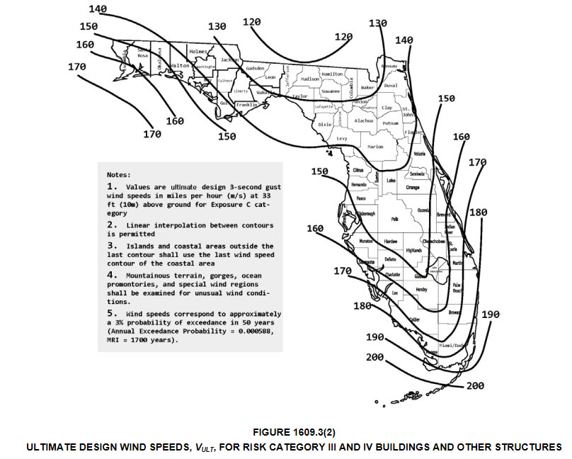
I'm surprised Taylor County building codes are only to withstand 130 mph gusts let alone sustained winds. I'm sure many are built above standards but older homes will be tested.
-
Speed is what might make the difference. I know when Hurricane Charley zipped across FL, Orlando had its highest gust ever at 108 amd that was pretty far from landfall. What surprised me is FL building codes are only to 130ish where this may landfall. I would think Valdosta older buildings/roofs could see high damage if hurricane force winds are sustained.
-
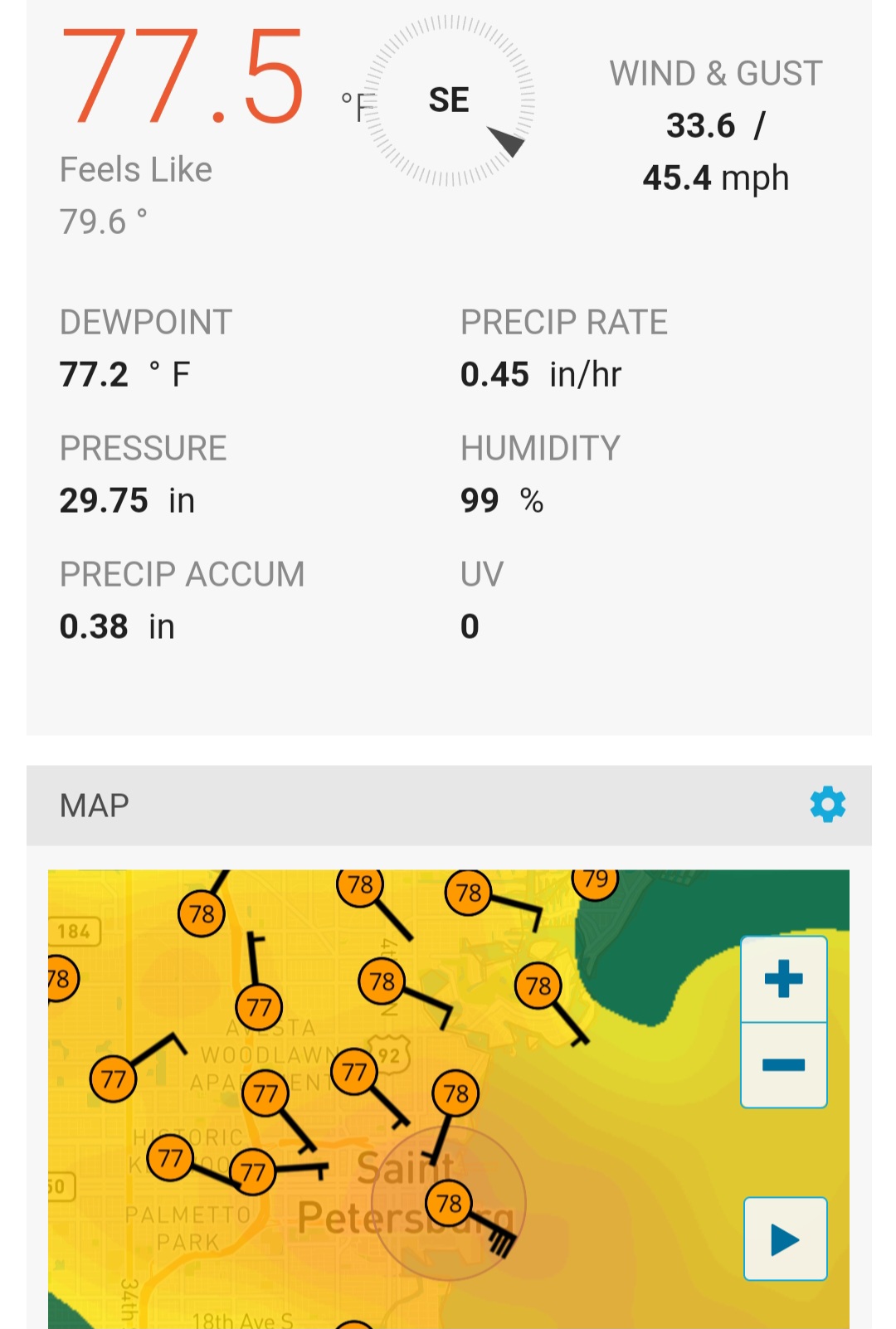
Was looking at some obs in the band over St Pete. Not bad. Almost tropical storm force winds.

-
Don't disagree on current consensus but GFS was not the outlier for Ian. UK and Euro were mostly the outliers.
-
Looks like tighter clusters mostly but many of the more western tracks show the cane moving NNW starting now or even should have by now. Time will tell.
-
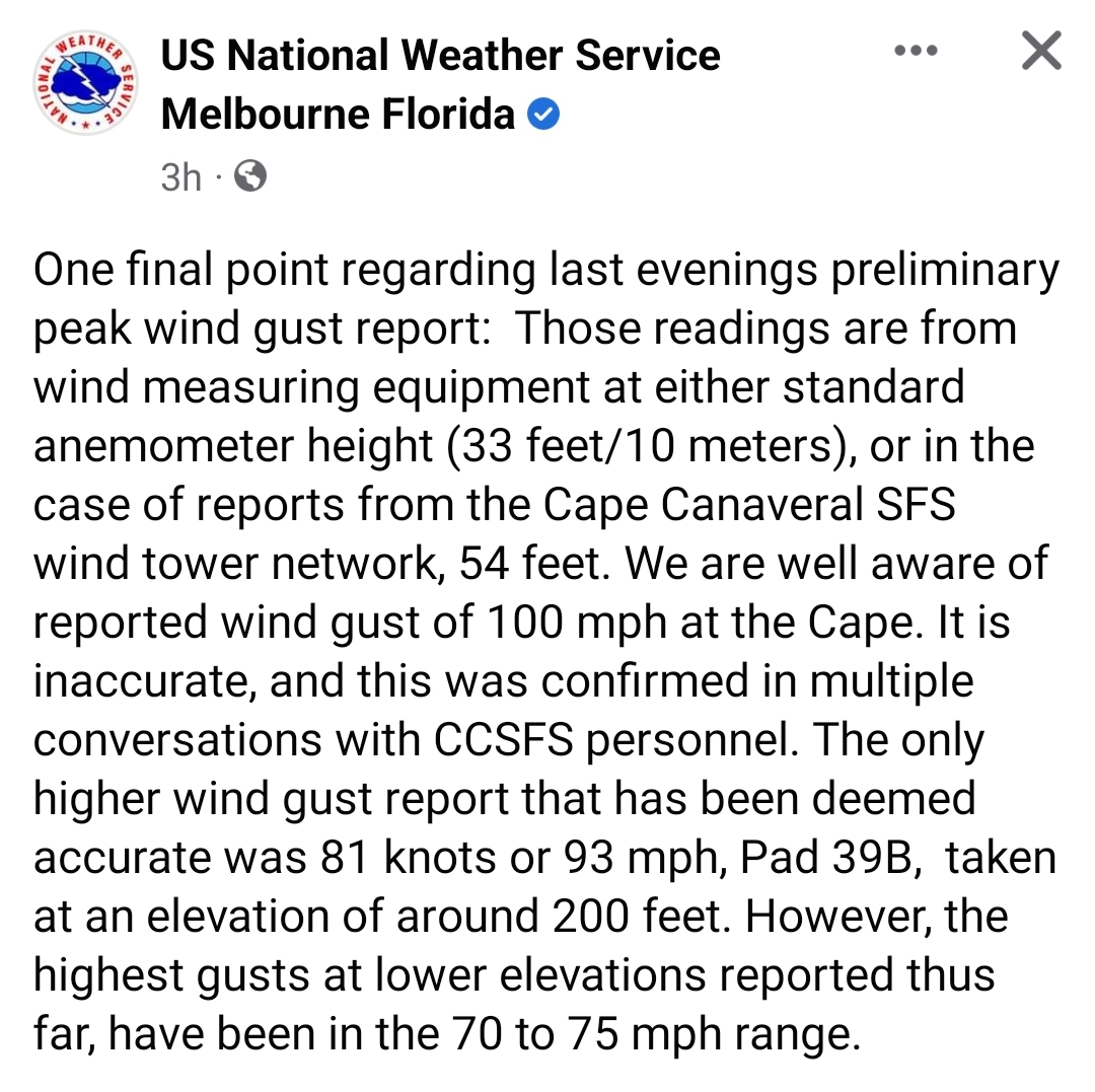
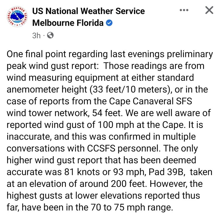
Some clarification from NWS Melbourne
-
What you describe is true of every tropical storm. Very rarely do rated winds verify, at least consistently.
-
At least 2 people died in Orlando related to electrocution of a fallen power line.
-
Orange County looked to peak at several hours of sustained TS (35-38 mph) with gusts to mid 50s. I heard transformers popping this morning.