TradeWinds
-
Posts
542 -
Joined
-
Last visited
Content Type
Profiles
Blogs
Forums
American Weather
Media Demo
Store
Gallery
Everything posted by TradeWinds
-
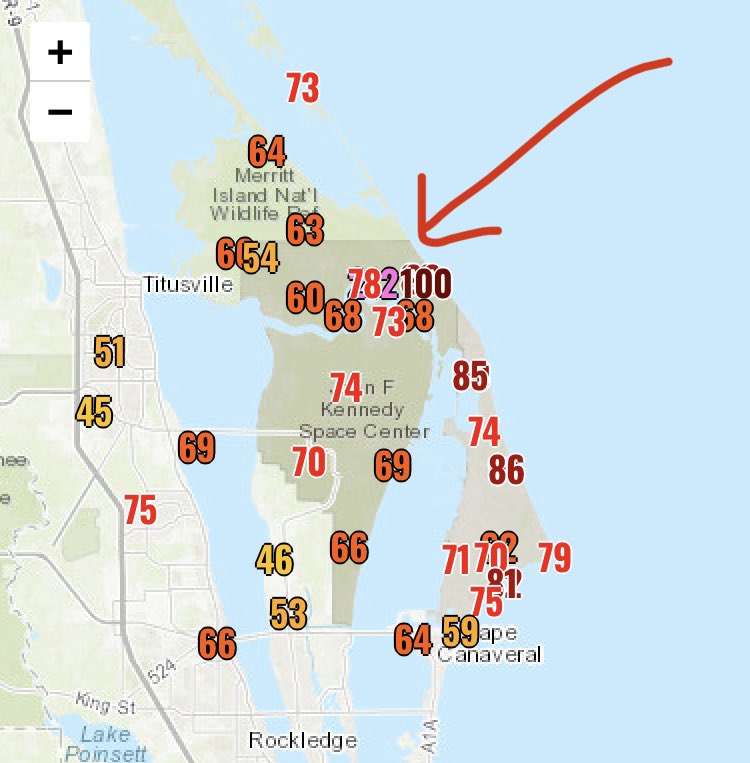
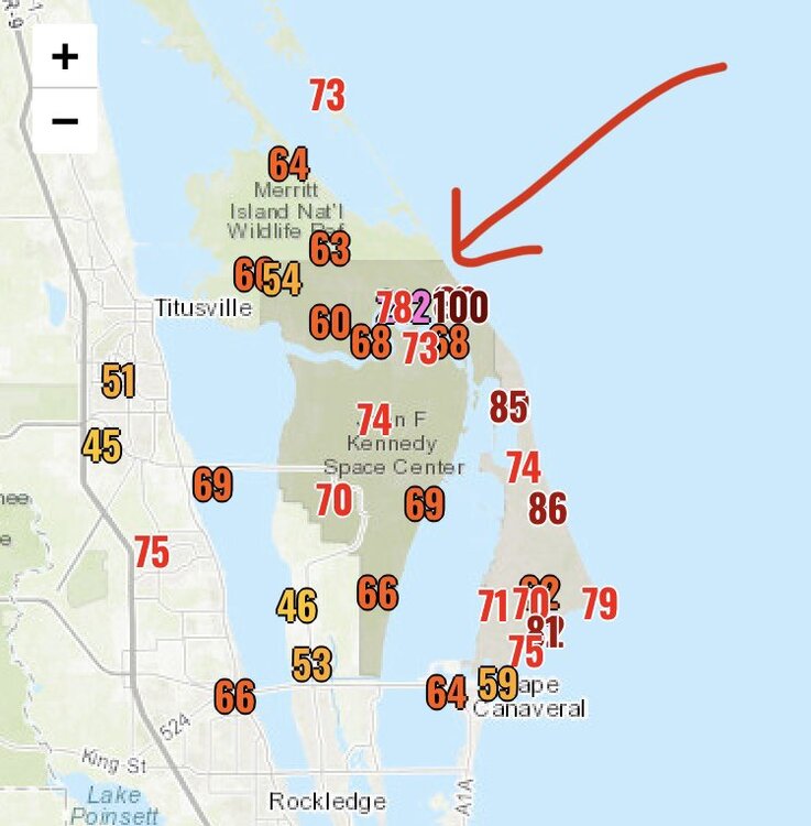
Here are some reported gusts. I believe cocoa had several 70+ mph gusts. The 100 was at 120 ft elevation as has been reported.
-
A little close off and tightening just before landfall. Impressive for mid Nov.
-
1935 - Miami (Nov 4) 1985 - Kate (Cat 2 into Panhandle Nov 21)
-
Quite impressive actually for the latest FL east coast landfall in recorded history.
-
It's like an optical illusion especially with wider eyes. They also use a composite radar I suppose. Even on radarscope, you can tell on a 20 frame loop it is WNW. Check out this loop and you'll see jogs but a general WNW. https://twitter.com/TMainolfiWESH/status/1590518516167368704?t=enBwT-KL08LxbScN89GQ9w&s=19
-
Interesting official forecast for Orlando just increased wind forecast at 7:30 PM update to peak 55-65 with gusts to 80. Don't see that verifying but we'll know more as reports start further south.
-
A doorbell video from Abaco. Looks like what you would expect from a TS. https://twitter.com/NashWX/status/1590433968822026240?t=OTtGHJ03ch35aw3Ipsr-fQ&s=19
-
A storm pic from Coopers Town as Nicole passed. https://twitter.com/Tribune242/status/1590431132113580032?t=IjG5Oh36pRIpJn_xnRaCiQ&s=19
-
2022 Atlantic Hurricane season
TradeWinds replied to StormchaserChuck!'s topic in Tropical Headquarters
GEFS now showing some earlier development compared to 24 hrs ago.
-
2022 Atlantic Hurricane season
TradeWinds replied to StormchaserChuck!'s topic in Tropical Headquarters
People also choose to build and live in hurricane prone areas, just as they choose to live in tornado alley or on a fault line. People also choose to evacuate or not. Ft Myers was in the cone the entire time. I'm sorry for their loss but personal decisions are real. -
Yes, a lot of people embarrassed themselves here. Also a shout out to the people that kept sharing the tweet about how well the GFS did. Our local met in Orlando actually lol'd last night when he mentioned the GFS.
-
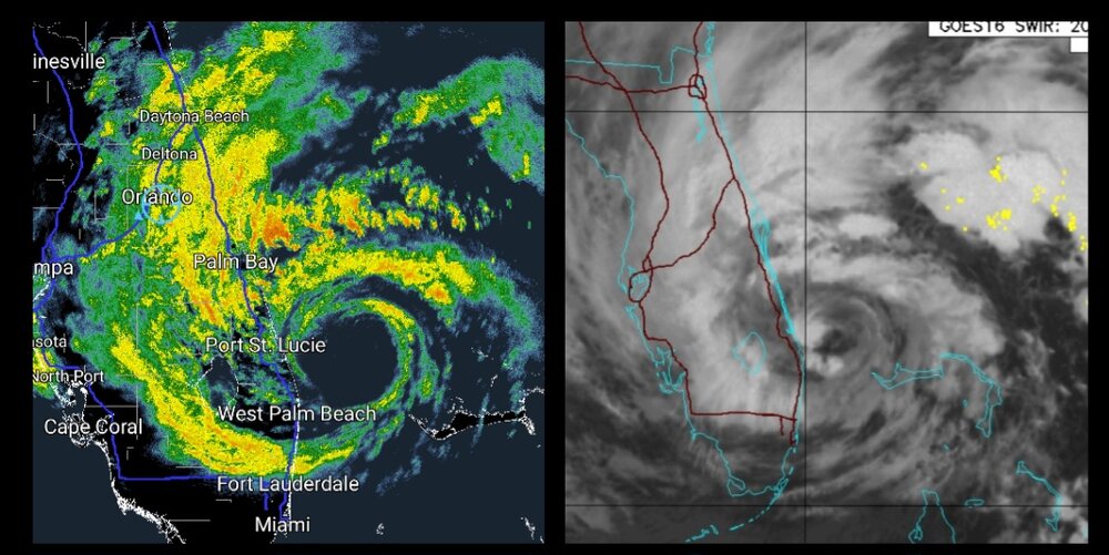
Orlando got hit hard. I received 14.13", almost 6" just in that band last night between midnight and 3 AM. Had to help neighbors as water entered their homes. The flooding in Orlando is ridiculous. We are now pushing 12 hours of tropical storm force winds and gusts to 60. Ian was a beast in FL.
-
Absolutely ripping in southern part of Orange County near MCO.
-
Our local mets explained why Orlando to Daytona is experiencing some of the highest winds this evening. Daytona had a 73 mph gust. The cold front is causing an intrusion of cold air. As the cold air sinks, it is efficient at bringing down the winds aloft. The rain is helping too.
-
This convergence zone over Orlando is producing high rain rates and wind. MCO last hour is 37 sustained and 60+ gusts. I'm seeing lightning and hearing thunder.
-
Squalls really picking up in Orlando
-
My official Hurricane Statement has increased every update since yesterday. Now says peak wind 55-70 with gusts 100. I'm near MCO.
-
I'm near MCO. Local news said center to come through around Kissimmee/St. Cloud. Called for possible sustained 50-70 with gusts to 90-95.
-
Every deviation also changes who gets the excessive rainfall.
-
Maybe just wobbles? As a personal side, N is better for me as I'm on the southern edge of the 15+ rain forecasts.
-
If a South of Tampa landfall occurs, I hope several here learn that models can sniff out changes. Too many posted here to throw them out...it's too south.
-
Agree. Very small and very fast. Charley still produced Orlando's largest wind ever recorded. 106 mph. Shows how fast the storm moved from S. Florida.
-
Very similar agreement on track between GFS and Euro. Euro is 24 hrs to get from landfall to Orlando. Wow. Drops a few lollipops of 30" Temple Terrace to Zephyrhills. Would be surprised if NHC doesn't adjust to at least I-4 corridor track next update.
-
On radar, it may have wobbled but looks minimal. Also looks to have wobbled back on the NHC track. But agree on longer term path.
-