Layman
-
Posts
724 -
Joined
-
Last visited
Content Type
Profiles
Blogs
Forums
American Weather
Media Demo
Store
Gallery
Everything posted by Layman
-
-
December 2024 - Best look to an early December pattern in many a year!
Layman replied to FXWX's topic in New England
There's a thread for that -
I was thinking that either came out wrong, or just right LOL
-
Slide that NE a touch and you jack and I get to work with more than just the tip of that pink zone.
-
Without high resolution Kuchera snow maps posted, these posts are becoming extremely difficult for the layperson!
-
New England Winter 2024-25 Bantering, Whining, and Sobbing Thread
Layman replied to klw's topic in New England
Thank you both for the info and details, I appreciate it. -
"I feel great, no head-throb here!" @40/70 Benchmark Am I doing this right?
-
New England Winter 2024-25 Bantering, Whining, and Sobbing Thread
Layman replied to klw's topic in New England
Thanks. What's parking like at Assembly Row? I don't mind a further ride especially if there's more to do. I also don't mind paying up for parking if it's valet, reserved, protected, etc. That Methuen theater was going to show it and I kept clicking to buy tickets but it kept saying something was wrong. 24ish hours later I try again and it's like the place has been fully shut down. LOT'S of rodent comments in those reviews LOL -
New England Winter 2024-25 Bantering, Whining, and Sobbing Thread
Layman replied to klw's topic in New England
Have any of you been to the IMAX theater at the Liberty Tree Mall in Danvers, or at Assembly Row in Somerville? Is one better than the other? There's a limited release movie coming out and none of the nice friendly New Hampshire theaters are carrying it so I have to make the trek down into the mean streets of Massachusetts. The last movie I went to was either the Phantom Menace or one of the Matrix movies so it's been awhile! I'm trying to find a place that isn't rat infested (the reviews of some of these theaters literally call out rats running across the floor!) and where my car will still be waiting with all 4 wheels attached when the movie's out. -
When you guys talk about some of the storms in the past that showed up on modeling then disappeared, only to come back again and be decent storms, were there any characteristics in the patterns that had you saying "No way, that storm can't simply disappear"? Or alternatively, do you recall statements like we've seen recently where people are saying "It's a garbage airmass", "the flow is too fast", "it's not digging deep enough out west", etc? As an observer it seems that everyone has given up on anything happening here. Just curious if the sentiment was the same with other storms in the past that materialized out of nowhere at the last minute or if it was obvious that something could and should happen.
-
December 2024 - Best look to an early December pattern in many a year!
Layman replied to FXWX's topic in New England
13.3 for the low. Coldest of the season so far. -
As simply an observer and consumer of this information, I really appreciate and enjoy reading the meaningful and in-depth analysis from the seasoned and knowledgeable folks in here devoid of the emotional hand-wringing due to as-yet-unknown outcomes that seem to control the frantic posting of many. Thanks for sharing your thoughts and ideas as this evolves into whatever it may ultimately become.
-
December 2024 - Best look to an early December pattern in many a year!
Layman replied to FXWX's topic in New England
If and when it does snow, I’m envisioning more than a few posters here “enjoying” the event like this -
From you lips to Tip's nips (or however that old saying goes,) I believe you've just taken 100% sole and full responsibility if a Grinch storm does in fact happen. Let's hope kdxken doesn't add your limb to the wood pile before 12/26
-
I was curious how much this area got in total as my tipper froze the night before and registered 0.01" until about 11am when I went out and cleared it.
-
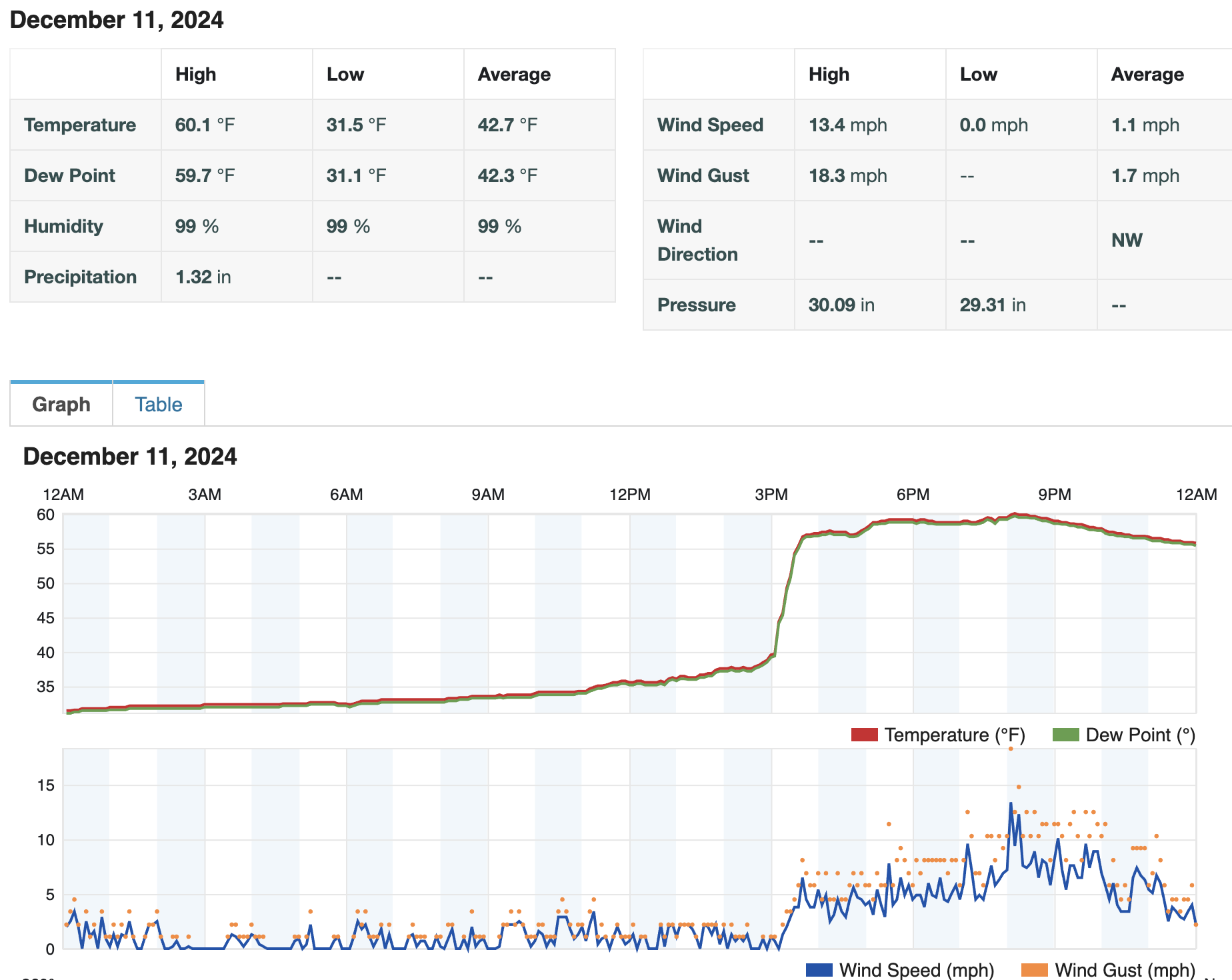
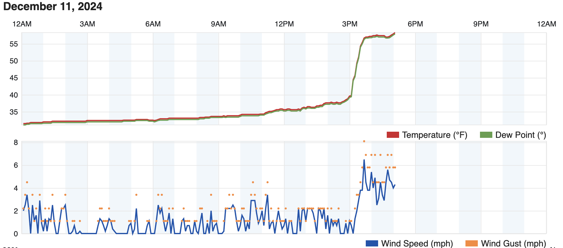
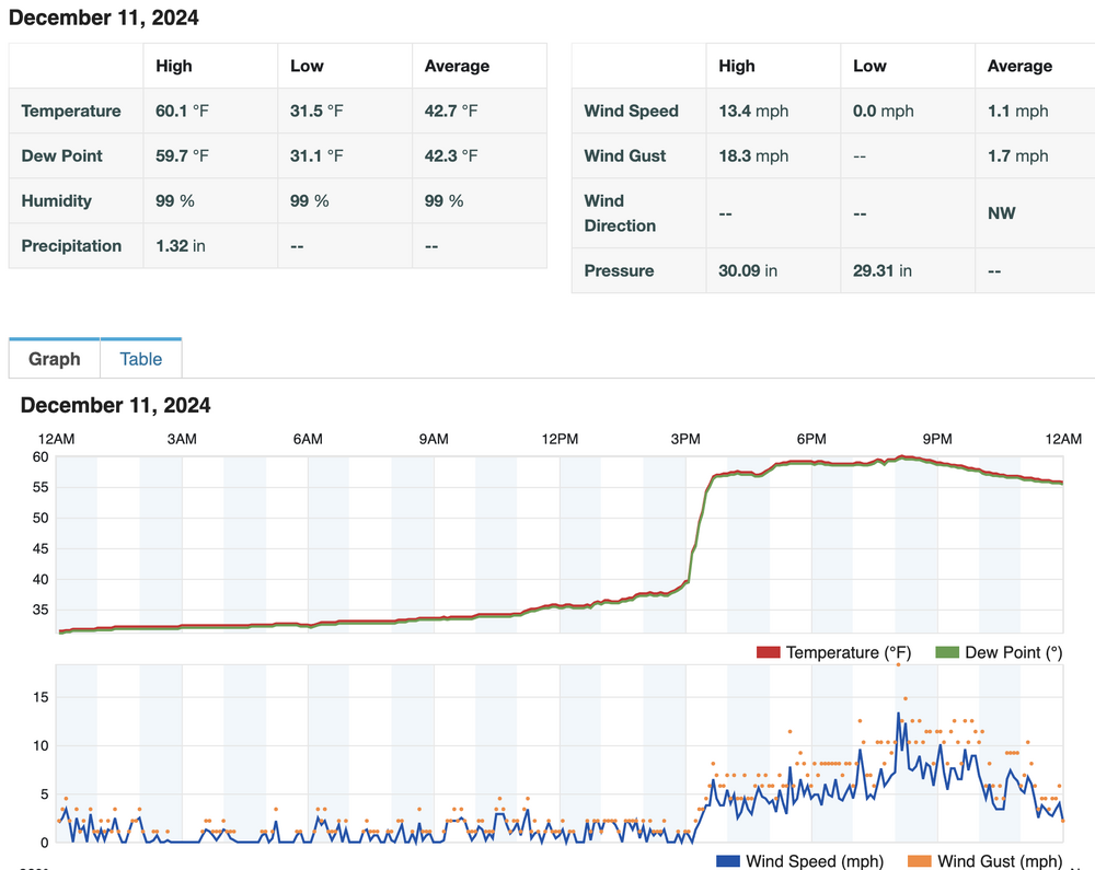
I was in a Zoom meeting from 3-5pm and missed this happening in real time. Temps did end up jumping real quick!

-
Had some decent heavier rain before noon today but my rain gauge apparently froze overnight and I don't know how much fell. Temp has slowly crept from 31 at midnight to 37 now. Local forecast was for 60 degrees by 9pm tonight with gusts 40-50mph. If that's happening still, I imagine this thing is going to come roaring in here before too long.
-
December 2024 - Best look to an early December pattern in many a year!
Layman replied to FXWX's topic in New England
Pardon me good Sir, dost though hath any inclinations regarding the impending blustery gales shewn on modeling over the next fortnight? -
December 2024 - Best look to an early December pattern in many a year!
Layman replied to FXWX's topic in New England
Where do you fly out of when you go up? MHT? BOS? MHT would be super convenient but they either don't fly direct out of there or I struggle greatly trying to find the proper flights! Sitting at 27.5 on the morning buried under several tenths of an inch of wintry precipitation after 0.43" of rain yesterday until ~8:30-9pm when it flipped. -
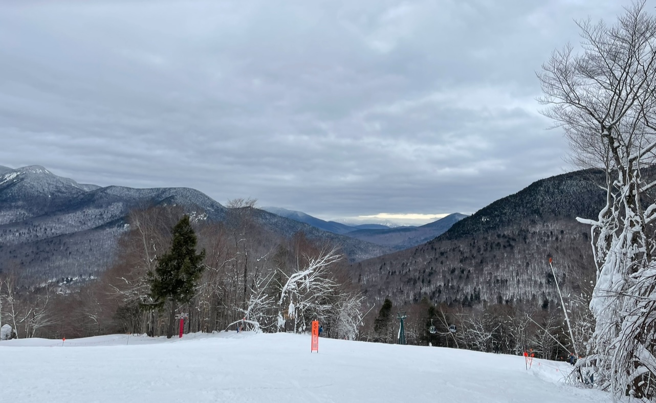
With 2”+ of rain and temps in the high 50’s expected, as well as Uncle Phil’s pending visit this week, we made a quick run up to Loon today. Conditions were reasonable for early season. Busier than I thought it would be but apparently everyone had the same idea to beat the rain. Loon isn’t our favorite place to go, but it’s close enough to make a game-time decision like today.

-
December 2024 - Best look to an early December pattern in many a year!
Layman replied to FXWX's topic in New England
1.5” - 2” here and festive. Beautiful morning.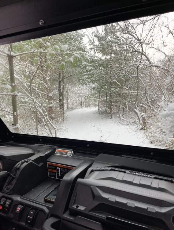
-
I find this topic very interesting so I created a thread hoping that a discussion can occur sans whining and sobbing about current weather:
-
Thank you @RDRY for posting this interesting Barron's link regarding the GenCast AI weather model: https://www.barrons.com/news/google-says-ai-weather-model-masters-15-day-forecast-cdc5793d Will, or can, AI improve forecasting reliability? What are your thoughts, opinions and/or experience? Will there still be a need for human interpretation of models going forward? AI is progressing at an incredible rate and continues to positively impact massive data processing: https://x.com/FutureJurvetson/status/1863649174358831312
-
December 2024 - Best look to an early December pattern in many a year!
Layman replied to FXWX's topic in New England
Clark? Is that you? -
For the record, I poke fun at some of your missives because the weather verbiage is way over my head. I appreciate the time and effort you put in to explain your perspective even if I don't understand it. It gives me something to look into, learn more about, consider, form my own opinions on, etc. Others here also take the time to explain what their thoughts are, how things may play out and why they think that may be the case. It's all appreciated and I'm sure there's a quieter group on here that takes the time to read the well thought out explanations and never responds, sarcastically or otherwise but benefits from the analysis. I'd encourage you and others to keep it up, in spite of some of us dbags because any off color reply is only in jest (or should be!) and we all learn from your explanations.