Layman
-
Posts
724 -
Joined
-
Last visited
Content Type
Profiles
Blogs
Forums
American Weather
Media Demo
Store
Gallery
Everything posted by Layman
-
“Meteorological pupa” ”Broomable fluffer” I learn new things in here everyday!
-
1/13/24 Sultan Slicer #2 - Heavy rain, snow, wind?
Layman replied to Torch Tiger's topic in New England
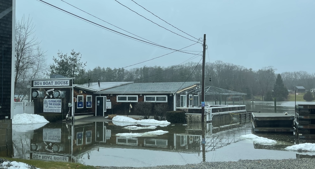
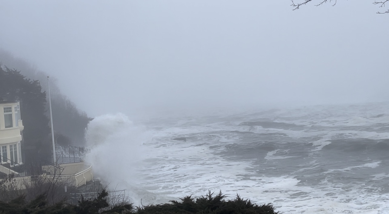
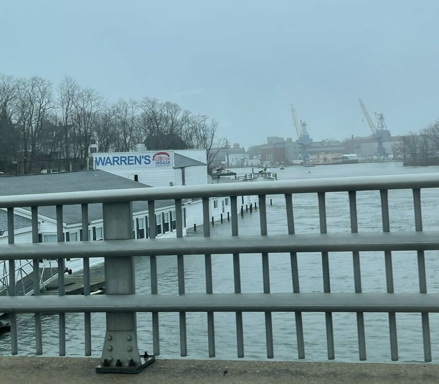
BG's Boathouse Restaurant in Newcastle NH Warren's Restaurant Kittery ME The Cliff Walk across from York Harbor Inn - the sea was angry here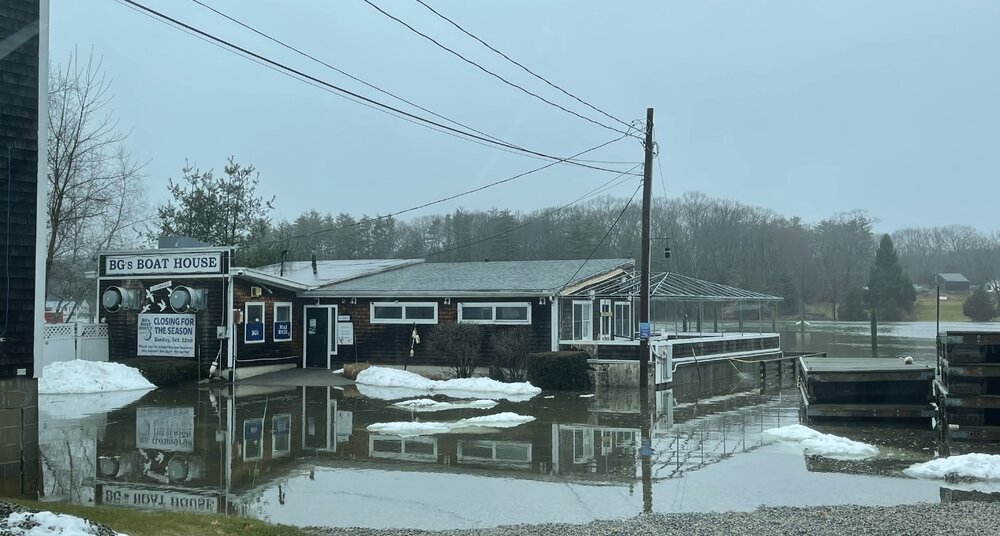

-
1/13/24 Sultan Slicer #2 - Heavy rain, snow, wind?
Layman replied to Torch Tiger's topic in New England
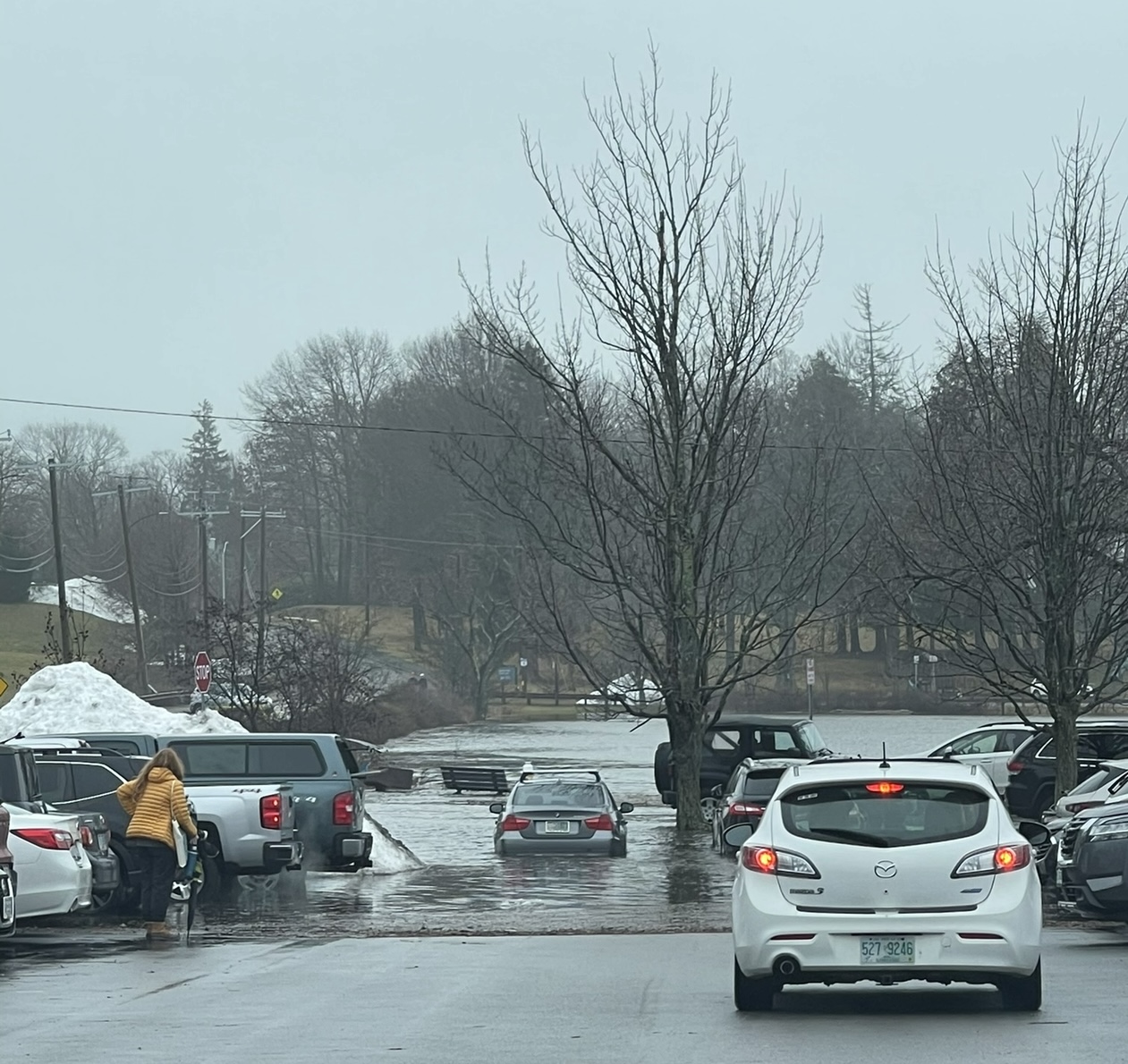
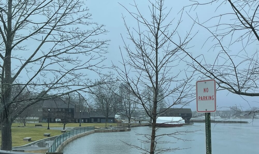
Those that were saying flooding was going to be a problem were definitely correct with this one. Spent yesterday morning out and about and grabbed some pics. Lots of closed roads on the NH seacoast and plenty of flooding. Here's a few noteworthy photos: Prescott Park and Strawberry Banke Portsmouth NH The Gundalow at Prescott Park - the water level on the wall is extraordinarily high. South Mill Pond in Portsmouth NH (Citizens Bank parking lot) Wentworth By The Sea Country Club entrance in Newcastle NH - Access to Newcastle was cut off on both sides of the island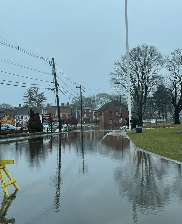


-
1/13/24 Sultan Slicer #2 - Heavy rain, snow, wind?
Layman replied to Torch Tiger's topic in New England
The relentlessest. We’ve added over an inch since 7am for a current total of 1.6” -
1/13/24 Sultan Slicer #2 - Heavy rain, snow, wind?
Layman replied to Torch Tiger's topic in New England
It’s a tad moist out there this morning. Sitting on an inch (so to speak) of rain since about 3am. Ground absolutely saturated. No significant winds, just a couple of noticeable gusts. Glad this one’s a quick mover but I don’t think we have a chance of drying out before the cold stretch hits. Looks like we’ll have some long term ice patches over the coming week or so. 41.2, just crested 1.01”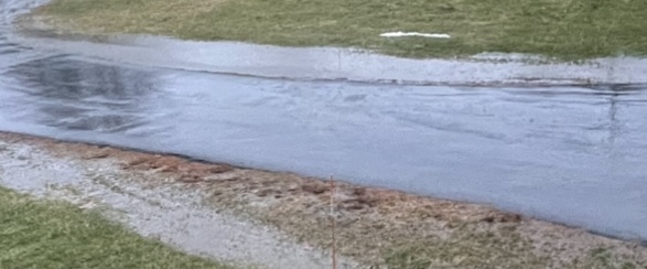
-
I was just out filling the wood racks to ensure I’ve got enough dry wood for the cold coming after this rain and saw this little guy out in the lawn. Don’t think I’ve ever seen this in January before. We also had a couple wasps out today. Granted, neither are as powerful predictors of weather like geese, but it caught my attention.
-
1/13/24 Sultan Slicer #2 - Heavy rain, snow, wind?
Layman replied to Torch Tiger's topic in New England
Flooding due to tides or rainfall amounts? My understanding was this is ripping through overnight, dropping 0.50" to 1.0" of rain around here and clearing out by noon. Ground is definitely saturated - I've still got a mini lake on the high side of my driveway, but at least for here, if it's not much more than 1" we shouldn't have much of an issue. But, I'm not on the immediate coast either so it's likely apples and oranges. -
This happened last year our west where they had the tremendous amounts of snow. I saw a video clip after the fact where the rescuer and rescuee had a beer together and chatted briefly about it. I seem to recall the guy who was buried didn't have a whole lot to say. I can't imagine being in that position and going from having fun, to oops, to uh-oh, to oh shxt, to this is it...
-
Colorful morning here. What’s that old saying? ”Dark at night, Ye have snow blight. Red at dawn your snow’s all gone”?

-
See, this is the kind of confidence we need to see around here It’s gonna snow boys!
-
Your gut’s one thing, but would you bet your scrotum on it?
-
I was looking through their site and you're right - I'm blown away by how many active products they offer. It's a HUGE variety. I could fill a fridge with 4 packs of things I'd want to sample from there.
-
Would not be surprised if costs are affecting those numbers. It can be an expensive habit for sure. Last time I ordered from Trillium it averaged out to something like $5.50/can. Unique stuff I find locally often runs $19-$22 for a 4 pack now. So many great options to choose from these days!
-
Are Treehouse beers sold in stores or only at their locations? Heard of them before but never been. Curious how they stack up to other local favorites.
-
Does this mean it's going to snow?
-
1/9-1/10 Now Morphing to Less-Than-Exciting Power Cutter
Layman replied to Torch Tiger's topic in New England
Something that got me on 10/31/2021 and a relative of mine in Bow a couple years earlier was a plugged outlet to our foundation drains. Both of us ended up with flooded basements after heavy rain storms. His was a good distance from his house and packed with dirt. Mine is very accessible and visible but got plugged with leaves and grass clippings over a 15 year period. Once I got it unplugged, it flowed for DAYS. Basement water level dropped almost immediately. Not sure if this could be the case for your sister, but it's definitely worth looking into. Very quick and easy fix for a major problem. -
1/9-1/10 Now Morphing to Less-Than-Exciting Power Cutter
Layman replied to Torch Tiger's topic in New England
A little cleaning up down there won't hurt. Just got back in from heading around the bay. Lots of really high water. Inches from the bottom of the year round docks. Very close to getting up to road level on a couple of the low bridges on Route 4. Also very little debris on the roads that we typically see when there's higher winds. My lawn's looking lush and green. May need to get a mow in after it dries out. -
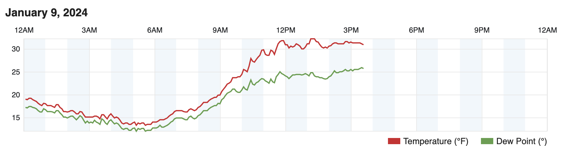
1/9-1/10 Now Morphing to Less-Than-Exciting Power Cutter
Layman replied to Torch Tiger's topic in New England
It’s kind of hard to see in the pic, but it’s showing we got 2.17” of rain since midnight. High gust of 27.3mph (not great placement for accurate gusts) and a high temp of 49.3 (39.9 at midnight).
-
1/9-1/10 Now Morphing to Less-Than-Exciting Power Cutter
Layman replied to Torch Tiger's topic in New England
Spitting snow, 31.1 degrees, no wind. -
1/9-1/10 Now Morphing to Less-Than-Exciting Power Cutter
Layman replied to Torch Tiger's topic in New England
Have we reached a few hours after sunrise yet? Asking for a religious friend. High of 32.2 here so far today.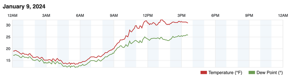
-
1/9-1/10 Now Morphing to Less-Than-Exciting Power Cutter
Layman replied to Torch Tiger's topic in New England
That 12/23 storm that rolled through made for some serious spring clean-up work last year. We lost the biggest and lowest pine branches off a group that's far enough from the house to not be a concern but it took days with a chainsaw to clean them up. The pines close to the house sound similar to yours in that they're bunched up and somewhat protecting each other. It can be unnerving to look up at them during those windy storms. The 4 I mentioned are just on my property, the abutting property has a lot more and a couple could reach but if that happens, it's a bad day for everyone! Got to be some serious event for that to happen. Good luck tonight! -
1/9-1/10 Now Morphing to Less-Than-Exciting Power Cutter
Layman replied to Torch Tiger's topic in New England
Unfortunately, I've got some big pines real close to the house. Four on my property that could be a problem with a robust N/NE wind which we thankfully rarely get here. -
OUCH! What kinda place you running there?
-
1/9-1/10 Now Morphing to Less-Than-Exciting Power Cutter
Layman replied to Torch Tiger's topic in New England
I'm concerned it's going to be a generator-ational event. Got plenty of gas and the generator already staged but would definitely prefer to keep the lights on.