mnchaserguy
-
Posts
247 -
Joined
-
Last visited
Content Type
Profiles
Blogs
Forums
American Weather
Media Demo
Store
Gallery
Everything posted by mnchaserguy
-
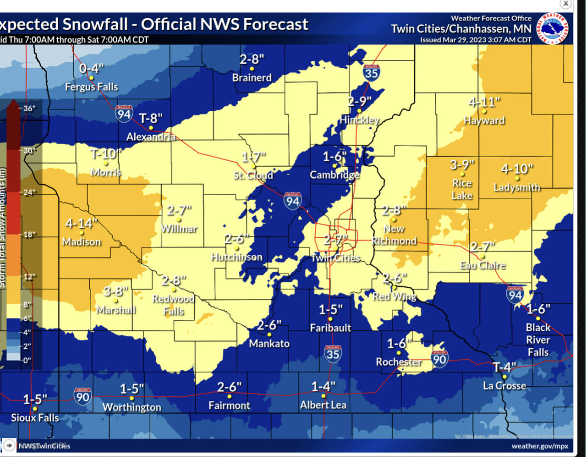
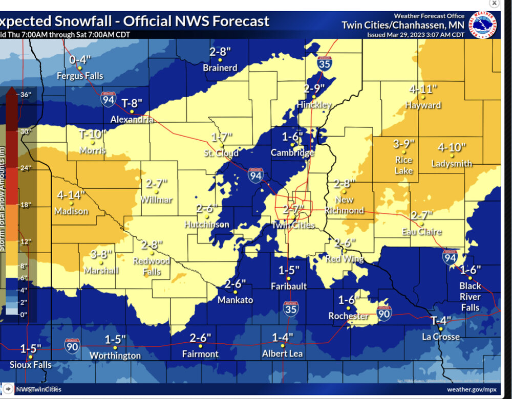
Some pretty wide ranges being thrown out by MPX. Goes to show how hard this one is going to be to predict. .
-
My point and click says 4-8” Friday night. This is getting a bit ridiculous. .
-
I would like to think I am going to be chasing this but at this point I don’t think it’s worth the drive from Minneapolis. If it slows down and/or shifts back north then it might be on the table for me. Right now this is a very progressive system which means fast storm motions. This is backed up by 50+ knot Bunkers right storm speeds. This will make keeping up with the storms difficult. The only area with backed winds are going to be tucked up right up on the center of the low. That really cuts down the area to work with and the window of opportunity to get a storm to produce. That being said, all it’ll take is one or two storms in that environment to go crazy. Very nice low and mid level SRH and 75 knots of effective shear. The biggest question will probably be the quality of moisture return, which the SPC mentions in their D4 outlook. .
-
Gonna be a nice 40 degree day around here before more snow moves in tomorrow. It’ll probably be mostly a slop fest but MPX did issue a WSW for it so maybe there is more potential than I want to admit. .
-
Chanhassen NWS is at 90.7” for the season. Unfortunately the records go off of the airport measurements and they’ve recorded significantly less than the NWS considering they’re only about 20 miles apart. Looks like the airport is sitting at 80.7”, which is still good enough for 7th snowiest. .
-
I believe there was a supercell that made it all the way from Oklahoma to Michigan during this event. .
-
Picked up 3”+ today. More than I expected. Looks like the snow will probably be ending here pretty quick. .
-
It’s snowing pretty good here in MSP right now. .
-
How did MKE do? Asking for a friend. .
-
The next big weekly snowstorm for MSP is on the 12z Euro for next Friday. Right now it shows about 15” imby. Let’s see how much that number gets whittled down between now and then. .
-
Radar doesn’t look all that impressive but it’s actually been coming down pretty good around MSP. It’s wet snow so it hasn’t added up to much but it has made the roads a nightmare. .
-
Lol it’s the same conversation though. I digress. This has gotten way too off topic and I don’t need people to complain about it like they did about Dallas. .
-
But where do you draw the line? By that logic you could argue there is no need to issue tornado, severe thunderstorm, or flash flood watches or warnings because everyone could just get this information from other sources. .
-
It’s been snowing for a couple hours now. Doesn’t look like it’s sticking to the pavement at all yet. .
-
I read through the comments too. Not a single one “laughing” at the NWS… .
-
I guarantee you the public doesn’t pay as much attention to a WWA vs WSWS as you think they do. I am willing to bet a lot of money most people had no idea it went advisory then warning, and most of them probably wouldn’t care even if they did know. .
-
Nice! Hasn’t added up to much at my office in St Louis Park so far. .
-
I don’t have the actual stats in front of me but I’m willing to bet from one seasonal extreme to the other MSP has a bigger temp swing than Dallas. .
-
It’s looking like a lot of the winter storm watch may not end up seeing winter storm warning criteria snow. The NAM and Nest barely want to give us WWA level snow amounts [emoji23] this storm went to crap quickly. .
-
The Euro, Nam, and Nest all really want to make this almost a non-event for MSP. Maybe 2-4” for me on the north side but if this trend continues we may not even get that. CAMs should be interesting. .
-
If it makes anyone feel better, we will probably be paying for it soon. How much do you want to bet Minnesota will be stuck on the cold side of the warm front this spring while the rest of you get to enjoy the warm sector? Or it might just snow here until May. That’s also a possibility. .
-
Models are painting a big dry slot for eastern and central MN. Nam is trending back north. Should be interesting to see if the globals start trending north too. That’ll be about the only way we get any significant amounts from this system. No matter what it looks like somewhere on the north side will get really screwed by that dryslot. .
-
The south trend continues. If this verifies our WSW will end up as only a WWA for 3-5”. .
-
I’m not overly excited. Snow amounts are trending lower across the board. The Euro has a mid tier WWA type snowstorm. Gfs and nam are borderline warning amounts from what I’ve seen the last couple runs. .
-
That was a pretty localized area. The north metro got 2-3”. .