Chris12WX
-
Posts
319 -
Joined
-
Last visited
Content Type
Profiles
Blogs
Forums
American Weather
Media Demo
Store
Gallery
Everything posted by Chris12WX
-
Hard not to envision this storm following the path of today's storm. #persistence
-
Biggie confirmed! Thanks!
-
Storm going exactly as forecasted here. Not sure how it’s a bust at moment.
-
3.0 flakes
-
Based on storm track and evolution, have to imagine someone gets something akin to this.
-
Feb 28th-March 1st long duration Miller B threat
Chris12WX replied to George001's topic in New England
What a fascinating storm system north of CT/RI and east of PVD/ORH (so basically AEMATT) in that for AEMATT we're basically waiting for OES. Precip doesn't really start cranking over here until the onshore breeze ushers enough moisture in. -
Did Chicago move? (but I get the point). December 2020 originally cut to Minneapolis, ran into a brick wall at the border and gave us a good storm. As long as the primary doesn't cross the border for poutine, then it can work.
-
Is this what its like to live in the mountains? Just non-stop flurries and S-.
-
Still mothballed
-
Feb 28th-March 1st long duration Miller B threat
Chris12WX replied to George001's topic in New England
At least I can take running the snowblower off todays to do list. -
No. Are you suggesting the GFS is the western goal post? Or that the GFS is wrong and the Euro is correct? Or that a blend of the two is more accurate?
-
Please explain.
-
Feb 28th-March 1st long duration Miller B threat
Chris12WX replied to George001's topic in New England
Last to the party. Model blows. -
Definitely more concerned about a cutter than a whiff.
-
Feb 28th-March 1st long duration Miller B threat
Chris12WX replied to George001's topic in New England
So the GFS blows. (Did I do that right?) -
Feb 28th-March 1st long duration Miller B threat
Chris12WX replied to George001's topic in New England
Eh….trending towards what’s the point? -
Feb 28th-March 1st long duration Miller B threat
Chris12WX replied to George001's topic in New England
GFS is a SWFE. We all know QPF is modeled high in those. 6-8". Euro is a whiff. Let's just whiff completely at this point. At the point in the season where give me a foot plus or stay away. -
Howling pretty good out there.
-
Feb 28th-March 1st long duration Miller B threat
Chris12WX replied to George001's topic in New England
Sure we can. Some of us have moved on to spring and dreaming of yard work. Bring back the 50s. -
Feb 28th-March 1st long duration Miller B threat
Chris12WX replied to George001's topic in New England
Not the move I was hoping for.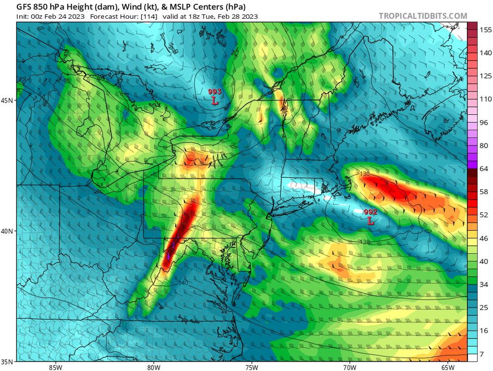
-
Feb 28th-March 1st long duration Miller B threat
Chris12WX replied to George001's topic in New England
850 mb actually closes off over the islands this run. Another improvement from 12z. -
Surface temperatures verbatim are too warm for snow anywhere in eastern half of continental US for this beast on the Euro.
-
Feb 28th-March 1st long duration Miller B threat
Chris12WX replied to George001's topic in New England
What if we include Bob's post to the total?
-
Feb 28th-March 1st long duration Miller B threat
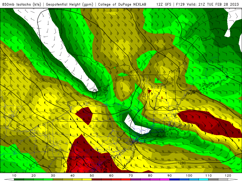
Chris12WX replied to George001's topic in New England
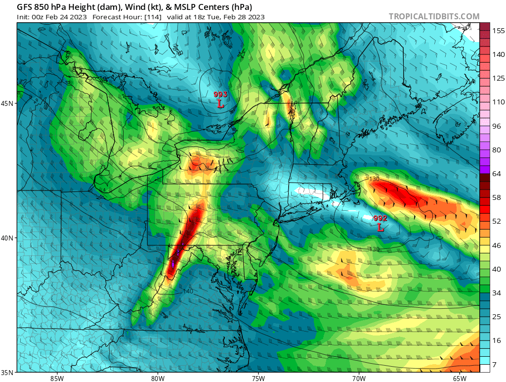
Positive move from the 12z suite. The main thing I am paying attention to is the 850 mb wind plots to monitor the easterly jet. Here is yesterday's 18z GFS plot which delivered a consensus 18" east of ORH: Now here is the 06z plot that "only" gave east of ORH widespread 10-12" amounts: Finally, here is this morning's GFS which returns to delivering a general 14-16" east of ORH. FWIW the Euro made a similar improvement.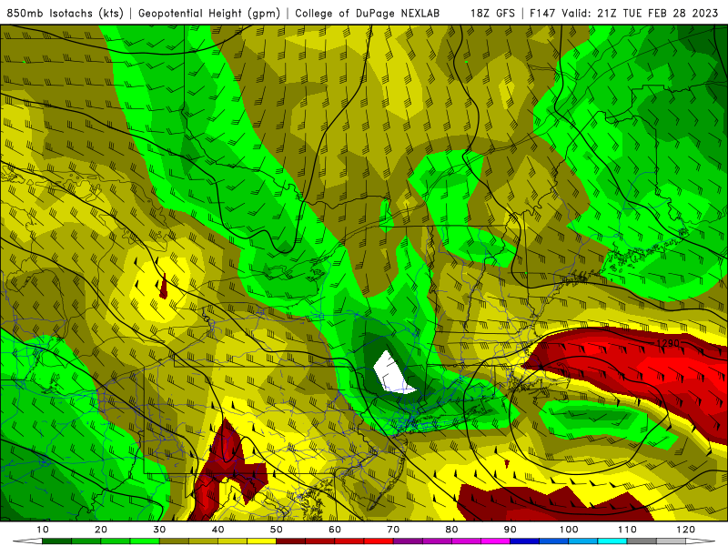
-
Feb 28th-March 1st long duration Miller B threat
Chris12WX replied to George001's topic in New England
I am for my backyard. I like where you sit.