AtlanticWx
-
Posts
650 -
Joined
-
Last visited
Content Type
Profiles
Blogs
Forums
American Weather
Media Demo
Store
Gallery
Everything posted by AtlanticWx
-
euro looks solid -- did take a step back but totals around suburbs remain the same prob bc of better banding
-
18z has been out since 6 pm lmao
-
March Medium/Long Range Thread: The Empire Strikes Back
AtlanticWx replied to stormtracker's topic in Mid Atlantic
gefs looks pretty crazy now. like 5" mean by hour 330 -
March Medium/Long Range Thread: The Empire Strikes Back
AtlanticWx replied to stormtracker's topic in Mid Atlantic
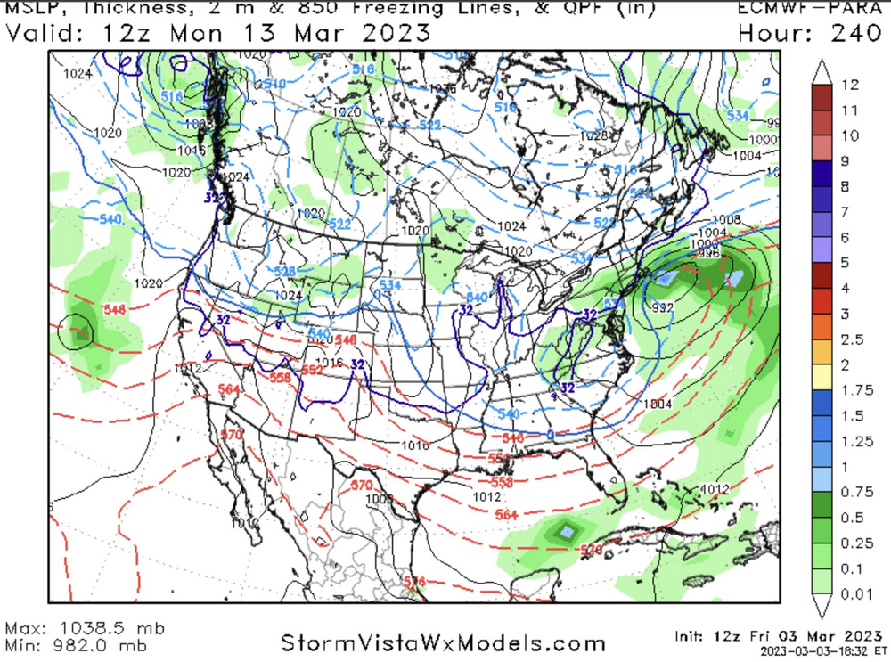
the march 3rd storm -
March Medium/Long Range Thread: The Empire Strikes Back
AtlanticWx replied to stormtracker's topic in Mid Atlantic
-
March Medium/Long Range Thread: The Empire Strikes Back
AtlanticWx replied to stormtracker's topic in Mid Atlantic
yeah the ceiling for this weekend storm is 3-5". latest eps 90th percentile maps for the weekend have a regionwide 3-4" -
March Medium/Long Range Thread: The Empire Strikes Back
AtlanticWx replied to stormtracker's topic in Mid Atlantic
i feel like in times we were in a bad mjo phase models trended warmer as soon as it initialized in said phase so i wonder if the same applies here -
March Medium/Long Range Thread: The Empire Strikes Back
AtlanticWx replied to stormtracker's topic in Mid Atlantic
already a 90% chance of >1" and 50-60% of >3" at hour 288 can't wait to see what it is at the end of the run -
March Medium/Long Range Thread: The Empire Strikes Back
AtlanticWx replied to stormtracker's topic in Mid Atlantic
it's 6 h precip, so if it snowed at hour 138 and it snowed at hour 141 it'll show snow at hr 144 even if it's rain -
March Medium/Long Range Thread: The Empire Strikes Back
AtlanticWx replied to stormtracker's topic in Mid Atlantic
ur not gonna get a huge snow event with a leaving airmass -
March Medium/Long Range Thread: The Empire Strikes Back
AtlanticWx replied to stormtracker's topic in Mid Atlantic
it's march bro what do u expect -
March Medium/Long Range Thread: The Empire Strikes Back
AtlanticWx replied to stormtracker's topic in Mid Atlantic
us wanting it to trend west and dig is a good place at 6-7 days out imo -
March Medium/Long Range Thread: The Empire Strikes Back
AtlanticWx replied to stormtracker's topic in Mid Atlantic
if the digging of the wave becomes a trend then like u said we're in the game -
March Medium/Long Range Thread: The Empire Strikes Back
AtlanticWx replied to stormtracker's topic in Mid Atlantic
all the ensembles dug the sw more as it reached the east coast i think that's exactly what we want, digging when it reaches the plains/EC -
March Medium/Long Range Thread: The Empire Strikes Back
AtlanticWx replied to stormtracker's topic in Mid Atlantic
ensembles look good which is good enough for now, eps was amazing -
March Medium/Long Range Thread: The Empire Strikes Back
AtlanticWx replied to stormtracker's topic in Mid Atlantic
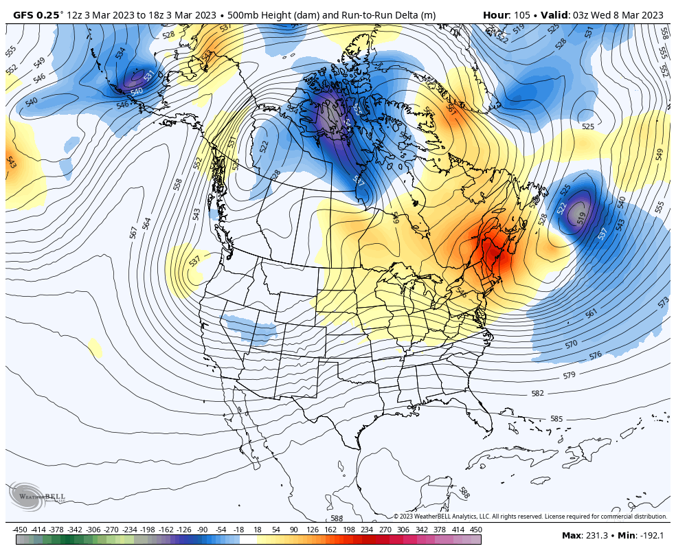
can't understate this, HUGE changes this run, digging even more than 0z last night
-
March Medium/Long Range Thread: The Empire Strikes Back
AtlanticWx replied to stormtracker's topic in Mid Atlantic
only at hour 60 and euro's already digging less -
March Medium/Long Range Thread: The Empire Strikes Back
AtlanticWx replied to stormtracker's topic in Mid Atlantic
on the bright side this could dig sm that we win after bc the secondary low develops rlly far S -
March Medium/Long Range Thread: The Empire Strikes Back
AtlanticWx replied to stormtracker's topic in Mid Atlantic
think it's like the alternate version of the euro or something ran w different params or maybe an alpha version of the next euro upgrade idk? and yeah it's for monday -
March Medium/Long Range Thread: The Empire Strikes Back
AtlanticWx replied to stormtracker's topic in Mid Atlantic
-
March Medium/Long Range Thread: The Empire Strikes Back
AtlanticWx replied to stormtracker's topic in Mid Atlantic
the march 3 storm was trending very favorably at this time and then switched up at a 5/6 day lead time. imo, ur trends usually always reverse at 5/6 days and we shouldn't be complaining for something that hasn't even reached the pacific shore yet. it only fully comes onshore at hour 144, please don't make presumptions when our main piece is LEAGUES away from being on shore. -
March Medium/Long Range Thread: The Empire Strikes Back
AtlanticWx replied to stormtracker's topic in Mid Atlantic
y'all will start freaking out immediately after a few bad op runs - don't count ur chickens before they hatch and this goes both ways -
March Medium/Long Range Thread: The Empire Strikes Back
AtlanticWx replied to stormtracker's topic in Mid Atlantic
we were analyzing 12z not 18z. this is an actual linkage with the -NAO this run, 12z had like +50 ridge anomalies lmao, pls don't twist my words -
March Medium/Long Range Thread: The Empire Strikes Back
AtlanticWx replied to stormtracker's topic in Mid Atlantic
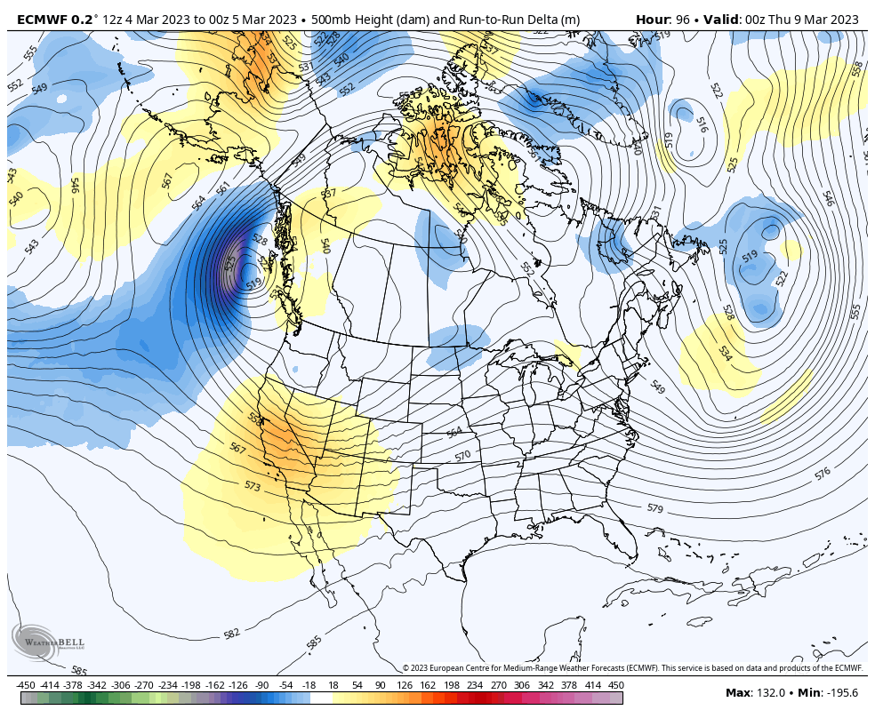
from 12z -> 18z, slightly faster S/W and most of all, a better phased and significantly stronger (513dm) 50/50 low.
-
March Medium/Long Range Thread: The Empire Strikes Back
AtlanticWx replied to stormtracker's topic in Mid Atlantic
this has always been the case, no? that ridge is doing nothing tho, it's like those light blue anomalies u see in front of a trough sometimes but it doesn't matter bc ur still torching at the surface