RU848789
-
Posts
4,002 -
Joined
-
Last visited
Content Type
Profiles
Blogs
Forums
American Weather
Media Demo
Store
Gallery
Everything posted by RU848789
-
Based on 12Z so far, you may end up being right.
-
The ensemble mean took a bit of a step back, but the Op didn't, at least at the surface with snow.
-
Really nice progression of QPF steadily increasing (likely snow at >10:1 ratios with temps around 20F) on the ECMWF-AIFS since yesterday. it now shows 0.5" QPF along 95 (that would be ~7" at 14:1 ratios) and up to 0.7" QPF for the coast (10" at 14:1), whereas it was only showing 0.1-0.2" QPF yesterday along 95. Considering that the AIFS has been the one model always showing a coastal scraper to even a complete miss for days, this is a big shift NW with the precip shield.
-
In 12 hours we went from every model showing a significant to major (or more) storm at 12Z to all but one of them showing nothing more than a coastal scraper (several inches towards the coast with little to no snow along/NW of 95). Not sure what's more unprecedented, most of the models showing a major to historic storm over the last 48 hours (which is extremely rare 4.5-6 days out) or that near consensus going into the shitter 4 days before the event for almost every model. Almost. Until the Euro saved Christmas, lol. Seriously, though, if the pros/experts are dumbfounded how are us hobbyists supposed to feel? One thing I will say, though, is that If a much less snowy outcome isn't a blip and is somewhat close to where we end up, it would prove to be perhaps the biggest modeling coup ever - for the Euro AIFS, which for days has been showing a coastal scraper or complete miss (apart from 12Z today, where it did show 3-5/4-8" snow for most) and has never shown a major storm unlike every other model (multiple runs). Let's hope it's not a coup. Debating not tracking at all tomorrow and being surprised on Monday, lol.
-
Somehow I missed this yesterday - fantastic post, thanks! And thanks for posting it here, also. Loved your inclusion of the historical anomalies associated with NYC snowfalls over 18" over 30 years and your excellent discussion of how the current projected pattern matches these features, as well as the easy-to-understand graphics showing what you discussed. I'm guessing that's how you guys see the 500 mbar pattern 24 to maybe 48 hours before the event in a model run and say "we're loaded for a big snowstorm" (or not if you don't see it) - would that be correct? I've never studied synoptics, so don't have much feel for how the pros infer this. I do have a couple of questions, though, if you can indulge me: i) I see that you showed the Euro pattern about a day prior to our potential event start on Thursday to match the NCEP graphic which says the anomaly is seen 1 day in advance ("preloading"), but I was wondering if one sees this anomalous pattern for a few days before such an event and not just at 1 day before the event (and could that give one more lead time on confidence in a big snowstorm); and ii) I get that this is the composite anomaly for 18" snowstorms, but is there data on how often such anomalies occur and what percentage of them lead to 18" snowstorms for NYC (or even any snow)? I would imagine there's some percentage of time when these patterns don't lead to big snow, although maybe less frequently when they're as close to the event as 1 day before the event, but that's just a gut instinct. TIA.
-
OBS-Nowcast Noon Saturday 2/15-Noon Monday 2/17
RU848789 replied to wdrag's topic in New York City Metro
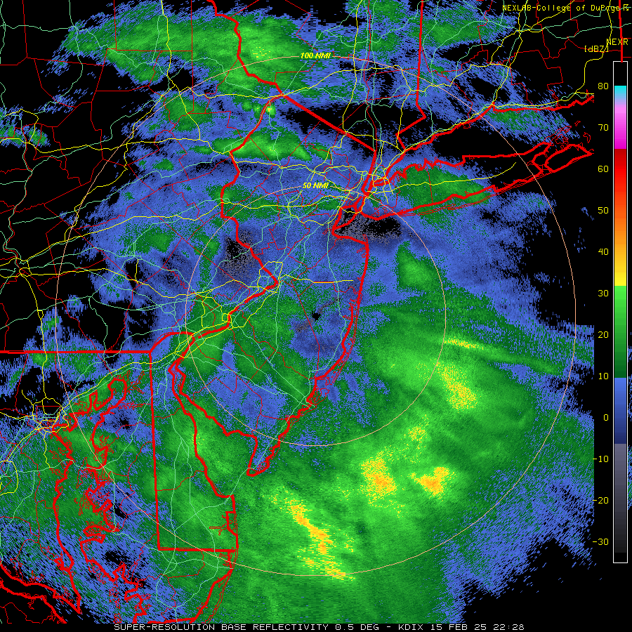
Strange winter part of the storm. Started out like gangbusters, putting down 1.1" in about 2.5 hours and then poof, precip just turned off since about 5:00 pm and it's now up to 33F with some light rain falling - possibly missed another 1-2 hours of snow. Seems like this one is over south of 78 for wintry precip and even north all the way towards 84 has changed over to sleet and freezing rain already. That's 1.1" vs. my prediction yesterday of 1.4" and the NWS prediction of 2.0", so a bit of an underperformer south of 78 and given similar reported ~1" or so amounts for most N of 78, that's a more significant underperformer there, where 1-3/2-4" were forecast, although reports of icing are common N of 78 with temps still below 32F, so could still be a significant impact event for that. These snow to mix to rain systems are just very difficult to predict accurately, especially aloft. Brings me to 15.9" on the season, which isn't too far behind normal for this date. -
OBS-Nowcast Noon Saturday 2/15-Noon Monday 2/17
RU848789 replied to wdrag's topic in New York City Metro
High wind warnings up for tomorrow afternoon for the entire region through Monday afternoon for west winds 25 to 35 mph with gusts up to 60 mph expected. https://forecast.weather.gov/wwamap/wwatxtget.php?cwa=PHI&wwa=high%20wind%20warning -
OBS-Nowcast Noon Saturday 2/15-Noon Monday 2/17
RU848789 replied to wdrag's topic in New York City Metro
Been wondering the same thing...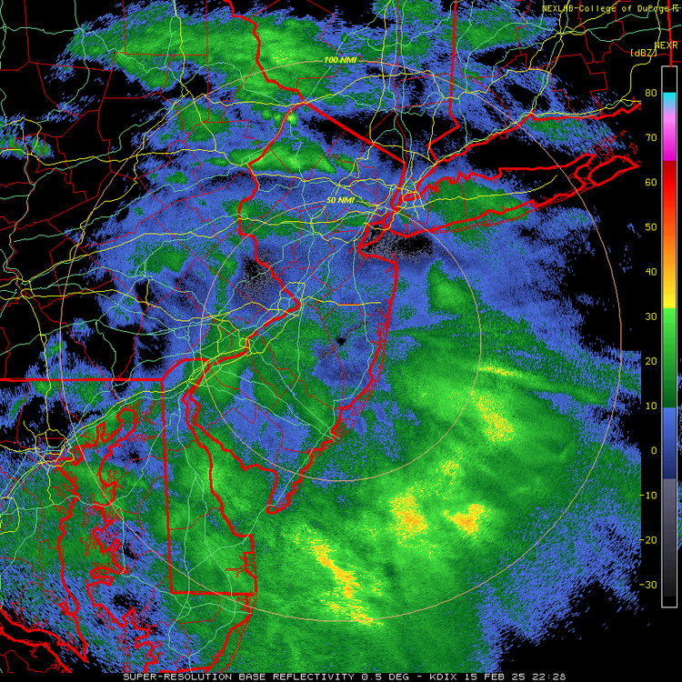
-
OBS-Nowcast Noon Saturday 2/15-Noon Monday 2/17
RU848789 replied to wdrag's topic in New York City Metro
Have had moderate snowfall for most of the last hour and we're up to 1.0" on the colder surfaces (it's still 32F), much faster than I expected; have about 1/4-1/2" on most untreated paved surfaces now, as you can kind of see in the pic below. Precip has lightened up a bit and looks like there might be a lull for the next ~20 minutes or so. -
OBS-Nowcast Noon Saturday 2/15-Noon Monday 2/17
RU848789 replied to wdrag's topic in New York City Metro
Surprisingly, we've had consistent light to moderate snow for 90 minutes and as of 3:45 pm we have 1/2" on the ground on colder surfaces and we also have a light coating on our driveway and sidewalks (untreated), whereas any street in town is just wet (we just ran errands and ate downtown). It's 32F, which is a touch colder than forecast and could mean this will overperform (vs. the updated NWS 1.5" forecast for my house; was 2.0" last night and my prediction last night was for an underperformer with 1.4" for my house) unless the warm air moves in more quickly. Sleet/mix line looks to be from about Philly to LBI, so could have several or just a few more hours of snow. It also helps that 75% of our property still had 1/2" or so of snow/sleet/ice cover, which is 32F, enabling an easier start of accumulation. -
Always interested in snow, but just not optimistic, south of 78, especially with 33-34F temps, light to moderate intensity and snow falling during the day (yes there is more indirect sunlight impact on 2/15 vs. 12/20). Earlier today when the NWS had 2.0" for my house, I predicted 1.4" for my house and that will mostly be on the grass. Unless one of the snowier, higher intensity models is right. One can hope.
-
Just posted about that, lol. No, accumulation on pavement is unlikely south of 78 IMO, assuming 33-34F surface temps and given at least some impact prior to about 4 pm from indirect sunlight in mid-Feb. Unless we get some nice banding with rates more than 1/4" per hour (which was our rate for Tuesday), which I haven't seen much indication of.
-
No guidance is perfect, but it has higher verification scores than any other model.
-
Same here and that was before seeing the non-snowy NAMs. I just have trouble seeing much accumulation for areas south of 78 at 33-34F with light to moderate intensity, especially prior to about 4 pm, as the sun angle matters in mid-Feb with marginal temps and low intensity.
-
Obviously, the incredible consensus for a major to historic snowstorm from the 4 global Op models, as well as the unusually snowy ensemble means for these models, are fantastic to see, but we know there's no guarantees in this game. Which is why the AIFS has me at least a bit worried, as it's been pretty good on tracks this winter...let's hope the AIFS is just wrong and comes back to a better track and wetter solution than the trend we've seen over the last 24 hours...
-
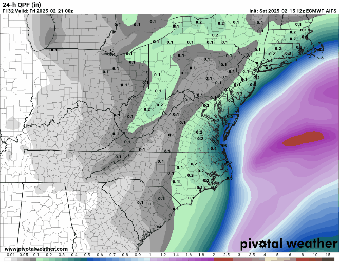
NWS snow and precip maps (1-1.5" of rain for most of us after the initial snow thump) and map of advisories for 2-3" (southernmost counties on the map) and 2-4" (north of those counties) are below, along with the NWS snow map for the NE US - huge snows for interior NY and New England, especially the ski resorts.
-
Yes, but those were both under 10" storms (at least for me) and I guess I was thinking about 12"+ storms. If somehow this holds onto decent consensus from day 6 through a 12"+ outcome, that would be unprecedented, IMO and pretty damn cool. It also occurs to me that There's likely only a few thousand people who know about this in the entire world right now, but there will be millions who know about it by tomorrow night, as this shit is about to go viral, big time.
-
I've been tracking storms since you were probably in grammar school and I've never seen consensus on an HECS like this 6 days out, let alone even 3-4 days out. It's incredibly exciting, but we all know how complex and uncertain NWP is, so assuming we're going to see an outcome like what we just saw from the models is a bit unrealistic - but possible. It's the "possible" part that's so exciting. Thanks, as always, for your efforts and for those from the other mets/experts.
-
And the Euro goes BOOM!! too. 4 for 4, 6 days out. Can only go downhill from here, lol.
-
So, the UK is the least snowy of the 3 major global models that have run so far and it shows 12-18" for the entire region for 2/20 and for DC to Boston really. The least snowy. The GFS shows the most with 18-32" and the CMC shows 12-24". I've never seen anything like this before in decades of tracking storms - consensus on an historic east coast snowstorm 6 days out. Obviously, storms like this are rare, so it might not happen at all, but this is as strong a signal for a significant to major snowstorm one is ever likely to see this far out. Euro up next and I have no idea what to expect. What's bigger than BECS?
-
Verbatim, the 0Z NAM is a huge improvement vs. 18Z, esp for NYC metro/CNJ. Sign me up.
-
Meh, still the least snowy model and no improvement vs. 12Z. Also, with modest rates and temps above 32F, this means difficulty accumulating during daylight (sun angle starting to play a bigger role now) and even after dark if temps are 33-34F, as per the model.
-
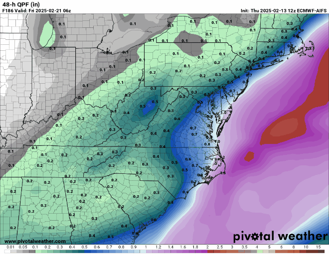
Finally got the NWS-Philly map update showing increased snowfall across the board, matching the increases seen for the NWS-NYC snowfall map above. I'd be pretty happy with 2" more snow, as per the map, even though I know it's going to get washed away - just fun to see and nice to add to the seasonal total. Still 42 hours until the precip starts, so we know more changes are likely; as the 2/8 and 2/11 mixed events, I'm concerned about getting more sleet/less snow than forecast.
-
NWS-NYC updated with increased snowfall, but NWS-Philly hasn't updated yet (even though their AFD discusses increased snowfall)...
-
Most forecasts call of an inch or more of rain after the changeover from snow and temps climbing into the 40s or even 50s on Sunday, at least for the 95 corridor and SE of there.