

RU848789
-
Posts
4,002 -
Joined
-
Last visited
Content Type
Profiles
Blogs
Forums
American Weather
Media Demo
Store
Gallery
Everything posted by RU848789
-
18Z NAM3km has been a very good predicted match to the actual radar the past couple of hours as per below for 8 pm. And I know past performance is no guarantee of future returns, but here's what the 18Z NAM returned. Just sayin'. And as an aside, the NWS-NYC discussion I posted earlier, explaining how the HRRR doesn't do well in northern fringe situations that still have lift, looks to be prescient. So far, as I hate spiking the ball early.
-
Snow started lightly here around 7:25 pm at 32F and we now have an official dusting as of 7:45 pm, but more importantly, intensity has picked up to moderate - this looks like 1/4" per hour snowfall and we hopefully have 6-8 hours of snow, so 2-3" is definitely possible, especially if we get some heavier rates by 9-10 pm as expected.
-
Snowing in Robbinsville and Asbury Park and even flurries on the south shore of LI.
-
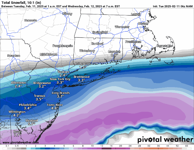
Almost forgot - prediction time., I'll go with 2.8" for our house, as I think the storm will overperform a bit vs. the 2.4" forecast for Metuchen, due to good snow/liquid ratios and the jet streak dynamics the NWS has discussed, along with decent frontogenetics as per several models and most of the models increasing snowfall (a little bit) at 12/18Z (except the HRRR which is a major outlier and is obviously being ignored by the NWS and others). Would be a bit disappointed with <2", but will still enjoy it.
-
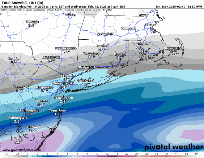
One of the best AFDs I've read in awhile, as I thought they did a great job of explaining their rationale for rejecting the HRRR (better than I did, which is not a surprise) and for why they think the storm will overperform a bit (good jet streak and frontogenesis) and deliver 12-13:1 ratio snow. Area Forecast Discussion National Weather Service New York NY 359 PM EST Tue Feb 11 2025 .NEAR TERM /UNTIL 6 AM WEDNESDAY MORNING/... Low pressure beginning to develop over the southeast this afternoon and will push ENE off the southern Middle Atlantic this evening into tonight. The region will continue to lie on the northern periphery of the precip shield. The latest model trends all support a bump up in liquid equivalent with around a few hundredths well inland, around a tenth southern portions of the Lower Hudson Valley and coastal CT, 0.15-0.20" in the NYC metro, and around 0.25" across Long Island. The NAM still appears to be the wettest of the guidance across the area, especially across the southern half with as much as 0.3" in NYC and near 0.4" across eastern Long Island. The 18z NAM has lowered QPF just slightly, but overall remains consistent with its last several cycles. Most of the 12z CAMs have come into better agreement with the rest of the model consensus. The HRRR is one of the drier models, but have noted it be to dry at times in previous events when the region is on the northern periphery. There are also several key ingredients that support the trend upward in liquid equivalent and resulting snow accumulation including a stronger 700mb frontogenesis signal combining with strong upper divergence from a 170-190 kt departing polar jet streak to our north. Models do tend to struggle with the combination of these features and have seen several past events over perform with lift accompanying a strong upper jet. The other factor is the majority of the model suite is indicating enhancement of the precip shield from Southern NJ up into the area at least the southeast portion of the area tonight as the coastal low emerges off the coast. Thermal profiles are also supporting an all snow event. Soundings indicate deep ice saturation within the dendritic growth zone for several hours tonight, especially across Long Island and portions of the NYC metro. The strongest lift appears to occur between 10pm and 2am with a decrease the rest of the night. The snow will begin to overspread from the south tonight between 7-9pm, becoming steady and continuing through the early morning hours. There is a period between about 10pm and 2am where snowfall rates could run between 0.25-0.50" per hour. There is even a low probability snowfall rates could briefly approach 1" per hour across Long Island from around 11pm-1am as the strongest forcing and deepest moisture combine. Snowfall rates will drop off from west to east from 3am to 5am. Some flurries may linger towards day break, but accumulating snow should end before sunrise. Snow to liquid ratios look higher with this event given we are on the northern periphery of the low and soundings show more of an ice saturation signal over one with deeper supercooled water saturation signal. For these reasons have gone closer to a 12-13:1 ratio. Updated snow totals are around 3 inches with potential of a few spots approaching 4 inches across Long Island. Elsewhere across the NYC metro and much of NE NJ and coastal CT, generally 1-2 inches are forecast. Locations closer to the south shore in Staten Island and southern Brooklyn and southern Queens could see up to 3 inches. More locations could see closer to 3 inches in the NYC metro and NE NJ if a wetter and further north trend continues. Amounts across the interior will be lower and generally less than an inch as this area is closer to subsidence from the high building in from the north.
-
I was living in Highland Park, NJ at the time, but don't recall that storm - how did it end up? What are your thoughts for tonight (siap)?
-
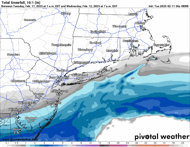
The HRRR has been pretty far off on the radar forecast vs. actual, especially for the 6Z run, which had low snowfall like 18Z does (12Z HRRR had much more snow to the NW), plus it's a significant outlier. The other day the NAM was a significant outlier and only ended up being partly right, i.e., for areas SW of about Allentown to NB, where most got little snow and a lot of sleet and ZR, but it got the precip amount and type NE of that line completely wrong, especially for NENJ/NYC/LI and the part it got right was in its wheelhouse of thermals aloft, whereas the HRRR isn't known for having some great skill in coastal snowfall. So, I'm ignoring it and obviously the NWS and others are too. Let's hope they're all correct.
-
Heavier snowfall moved significantly NW up through 95 (SW of about NB) and was the same or slightly less along and NW of 95 for NENJ/NYC. The 1" line actually bumped north a little bit, but that's likely noise. Note though that the NAM is warmer than some models near the NJ coast (33-34F) so the Kuchera ratios are <1 there .
-
The risk of a major bust low just went down as the HRRR model, which was way less snowy than the other models, finally moved significantly further north...it's still on the low side of the models, but it's no longer a crazy outlier
-
Here's the NWS map for wave 1 only from 7 am today through 7 am Weds and below that is the map for wave 2 only from 7 am Weds thru 7 am Thurs. I just stumbled upon the NWS snowfall portal tool yesterday from a poster on the RU board and it's very cool if folks haven't seen it. It allows one to pick any NWS office area and timeframe up through 66 hours, creating snowfall maps and to hover one's cursor over any location to get the snowfall for that period (a much better version of the point-and-click feature)....and there's a button to create "official NWS snowfall maps" like the one below. The link for this is well hidden, lol, on the winter weather page just above the usual maps where it says, "Click here for the NWS Probabilistic Precipitation Portal" - this link then comes up: https://www.wpc.ncep.noaa.gov/Prob_Precip/
-
Zoomed in 0Z Euro vs. 18Z: nice bump up in precip/snow amounts for the northern folks...
-
Disagree - these look the same to me; maybe the slightest tick north. Also the map you posted goes out to 4 pm Weds - yes there is some very light snow, but I doubt any of it will accumulate with very light intensity during daylight with temps above 32F.
-
There's obviously some reason the NWS has the snowfall forecast higher than most models - maybe they're buying the NAM, as they look very close.
-
There's obviously some reason the NWS has the snowfall forecast higher than most models - maybe they're buying the NAM, as they look very close. And I just noticed that the NWS had put up advisories for SE Bucks, Mercer and Monmouth (must've been looking at an old map), so Middlesex/Somerset aren't that far away from advisory level snows.
-
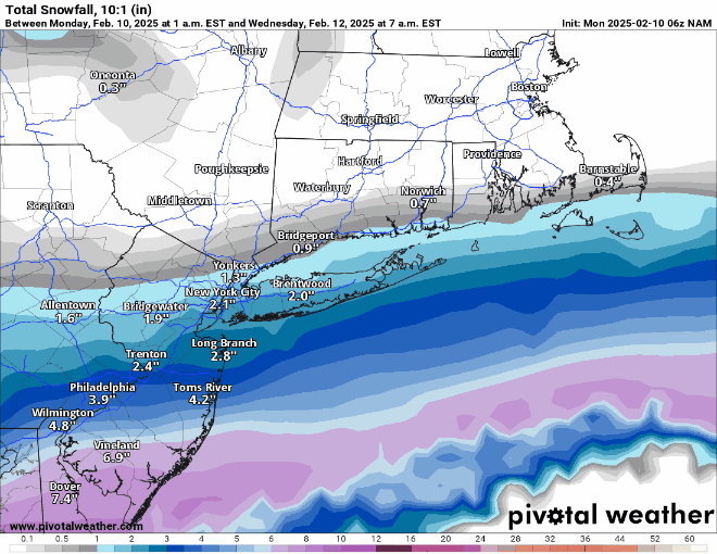
Zoomed 12Z vs 6Z NAM - nice! NYC at 2.5" (10:1; Kuchera for NYC is about 1.2) and only 30 miles from 4".
-
Thanks, but why wouldn't you include Warren County on your maps? i get it's not part of the formal NYC MSA, but it part of the larger CMSA and just looks funny, geographically to be omitted, as it's closer to NYC than a bunch of the counties in the DMA. Just my $0.02. https://en.wikipedia.org/wiki/New_York_metropolitan_area
-
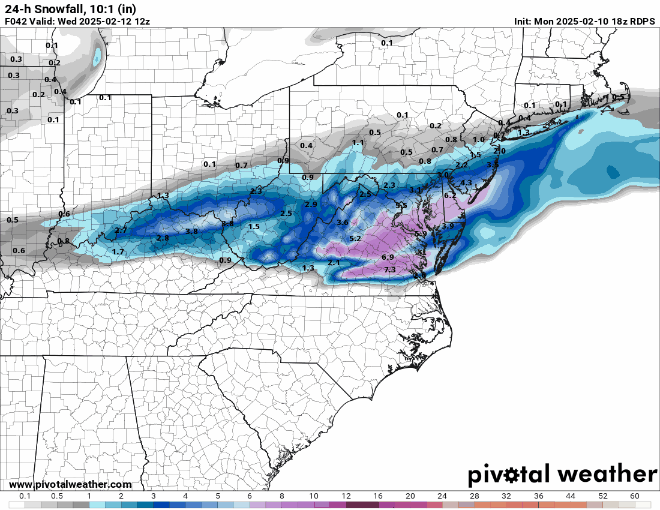
Here's the NWS-Philly versions of those maps. Agree that no model shows anything that high right now, but I always thought the 10% high end maps were about potential and those amounts would only require about a 75-100 mile north shift of the snow shield. This also appears to be only for wave 1, with wave 2 not having any precip until after 7 pm Weds. This is reflected in their updated AFD. Area Forecast Discussion National Weather Service Mount Holly NJ 314 AM EST Mon Feb 10 2025 SHORT TERM /6 PM THIS EVENING THROUGH WEDNESDAY/... Snow will fall Tuesday night through Wednesday morning with a primary focus over the eastern shores of Maryland, Delaware, and southern New Jersey, where 4 to 6 inches of snow will fall. From along the I-95 corridor to the Fall Line, 2 to 3 inches of snow will fall, with 1 to 2 inches over the southern Poconos, northern New Jersey, and the Lehigh Valley. Will keep the Winter Storm Watch in effect for the eastern shores of Maryland, Delaware, and southern New Jersey. Behind the departure of the secondary low, the first low that was over the Gulf Coast states will depart off the Mid-Atlantic coast Wednesday morning. Another low organizes and develops over the Ark-LA-Tex area Wednesday morning, tracks northeast during the day, and tracks through western Pennsylvania and western New York Wednesday night as another secondary low develops out ahead of it. That low passes through New Jersey and will be off the Jersey Shore late Wednesday night. Precip Wednesday and Wednesday night will feature more in the way of a mixed bag of wintry precip, first over Delmarva and southern New Jersey Wednesday morning, then the wintry mix lifts north through the day, and Wednesday night. Wintry mix changes to plain rain from south to north Wednesday night. During this time, snowfall will range from 1 to 2 inches over the southern half of the forecast area, and from 2 to 3 inches over the northern half.
-
Kids were skating during the cold spell a couple of weeks ago, but not now.
-
As I had mentioned, I was way too pessimistic here, as we had a decent amount of heavy sleet and heavy freezing rain in the ~90 minutes after this post, so when I went out to shovel around 12:30 am, after the precip had stopped, I measured 1.6" of slop, which probably contained 0.5-0.6" of QPF (I didn't do a ratio, but saw a radar estimate in that range). If I had to guess it was 0.5" of snow (0.05" QPF), which I saw early, plus 1.1" of 2.5:1 sleet (0.44" QPF) and 0.1" ZR for 0.59" QPF. That's a guess, but I can absolutely tell you that this slop kicked my ass (and shoulder, lol) as it felt like a 5-6" of snow shoveling, as it took almost 2 hours.The 1.6" was also probably more, but had compacted with the alternating sleet and rain, but anyway, it brings my seasonal total up to 12.8". Now let's get some more next week.
-
As I had mentioned, I was way too pessimistic here, as we had a decent amount of heavy sleet and heavy freezing rain in the ~90 minutes after this post, so when I went out to shovel around 12:30 am, after the precip had stopped, I measured 1.6" of slop, which probably contained 0.5-0.6" of QPF (I didn't do a ratio, but saw a radar estimate in that range). If I had to guess it was 0.5" of snow (0.05" QPF), which I saw early, plus 1.1" of 2.5:1 sleet (0.44" QPF) and 0.1" ZR for 0.59" QPF. That's a guess, but I can absolutely tell you that this slop kicked my ass (and shoulder, lol) as it felt like a 5-6" of snow shoveling, as it took almost 2 hours. But on the plus side, I did get to meet @Allsnowas he was plowing our street and saw me out there in my RU gear and asked if I was RU#s, so we chatted for a bit which was nice and then we both went back to work. The 1.6" was also probably more, but had compacted with the alternating sleet and rain, but anyway, it brings my seasonal total up to 12.8". Now let's get some more next week.
-
The last hour has been a rollercoaster with precip flipping back and forth between moderate to heavy freezing rain and sleet at 30F. Crazy storm with the back edge of the precip approaching.
-
Spoke too soon. Just flipped back to pouring sleet - no idea what will happen next, lol.
-
Switched over to freezing rain a few minutes ago, earlier than expected, so I just took my final measurement of 1.25" of sleet/snow, bringing our season total up to 12.4". Disappointing we didn't get the 2.5" of snow/sleet I guesstimated and especially would've liked more snow, but that's the way it goes sometimes. Not loving having an hour or more of ZR, which could put down 0.1" or more of ice with temps at 29F.


