blackngoldrules
-
Posts
1,859 -
Joined
-
Last visited
Content Type
Profiles
Blogs
Forums
American Weather
Media Demo
Store
Gallery
Everything posted by blackngoldrules
-
I think the line did weaken some as far as the precip goes. But still very high winds, especially when it first hit. Enough to knock my power out. Sent from my SM-S931U using Tapatalk
-
My power just went out. Very high winds. Sent from my SM-S931U using Tapatalk
-
If this holds together, about to get ugly here. Sent from my SM-S931U using Tapatalk
-
Getting some hail with this line. Sent from my SM-S931U using Tapatalk
-
I'm definitely in spring mode now. Hard to believe the anniversary of the blizzard of 93 is coming up. That was 32 years ago! I was still in high school and now I'm turning 50 this year. Lol Sent from my SM-S931U using Tapatalk
-

Pittsburgh/Western PA Winter 2024-2025 Thread
blackngoldrules replied to Rd9108's topic in Upstate New York/Pennsylvania
I probably got a slushy inch in Bethel. Missed out on that heavy band earlier that hit just north of me. Sent from my SM-S931U using Tapatalk -
Pittsburgh/Western PA Winter 2024-2025 Thread
blackngoldrules replied to Rd9108's topic in Upstate New York/Pennsylvania
Sucks to be in the bullseye 5 days out and on just one model. Just to tease us a little before the rug gets ripped out yet again. Lol Sent from my SM-S931U using Tapatalk -
Pittsburgh/Western PA Winter 2024-2025 Thread
blackngoldrules replied to Rd9108's topic in Upstate New York/Pennsylvania
The Jan. 94 storm will always be my favorite. I got 27 inches where I lived in Westmoreland County at the time. And it was mostly a daylight snowfall as well. And it was moderate to heavy for most of it. I was off school for a week. That was my senior year. I knew at the time that I'd probably never see one like that again, and so far I've been right. I'm talking the intensity of the snow, combined with it snowing all day, and the heavy amount I got there. We've had a few big ones since, but that one just checked off all the boxes for me when it comes to the perfect snowstorm. I wish I had a camcorder to record it but didn't. Sent from my SM-S931U using Tapatalk -
Pittsburgh/Western PA Winter 2024-2025 Thread
blackngoldrules replied to Rd9108's topic in Upstate New York/Pennsylvania
Snowing hard in Bethel now. Yeah, I'd say at least another inch out of this batch coming through. Sent from my SM-S931U using Tapatalk -
Pittsburgh/Western PA Winter 2024-2025 Thread
blackngoldrules replied to Rd9108's topic in Upstate New York/Pennsylvania
My power has gone out briefly a couple of times. Sent from my SM-S931U using Tapatalk -
Pittsburgh/Western PA Winter 2024-2025 Thread
blackngoldrules replied to Rd9108's topic in Upstate New York/Pennsylvania
Looks like some more in Ohio developing and heading our way. Maybe eek out another inch? Sent from my SM-S931U using Tapatalk -
Pittsburgh/Western PA Winter 2024-2025 Thread
blackngoldrules replied to Rd9108's topic in Upstate New York/Pennsylvania
You guys want a blast from the past? Lol Sent from my SM-G991U using Tapatalk -
Pittsburgh/Western PA Winter 2024-2025 Thread
blackngoldrules replied to Rd9108's topic in Upstate New York/Pennsylvania
Snowing very hard in Bethel right now. I'll enjoy this for another 10 minutes! Lol Sent from my SM-G991U using Tapatalk -
Pittsburgh/Western PA Winter 2024-2025 Thread
blackngoldrules replied to Rd9108's topic in Upstate New York/Pennsylvania
I'm on the back edge of it in the South Hills now but it looks like there's some backfilling so maybe we'll get a little more? Sent from my SM-G991U using Tapatalk -
Pittsburgh/Western PA Winter 2024-2025 Thread
blackngoldrules replied to Rd9108's topic in Upstate New York/Pennsylvania
I can confirm. It's light snow but it's coming down steadily right now. Sent from my SM-G991U using Tapatalk -
Pittsburgh/Western PA Winter 2024-2025 Thread
blackngoldrules replied to Rd9108's topic in Upstate New York/Pennsylvania
The snow has finally started here. All about nowcasting now. Sent from my SM-G991U using Tapatalk -
Pittsburgh/Western PA Winter 2024-2025 Thread
blackngoldrules replied to Rd9108's topic in Upstate New York/Pennsylvania
I would think Allegheny will eventually be added. At least the southern half of the county right now can get warning level snow. Maybe, if we're lucky, that can keep pushing further north. Sent from my SM-G991U using Tapatalk -
Pittsburgh/Western PA Winter 2024-2025 Thread
blackngoldrules replied to Rd9108's topic in Upstate New York/Pennsylvania
NWS keep lowering my totals. Started out 2-4 Sunday night and 2-4 for Monday. Now, 1-3 for both instead. Sent from my SM-G991U using Tapatalk -
Pittsburgh/Western PA Winter 2024-2025 Thread
blackngoldrules replied to Rd9108's topic in Upstate New York/Pennsylvania
This may be one rare case where I'm in a better spot being at the southern border of Allegheny County. Sent from my SM-G991U using Tapatalk -
Pittsburgh/Western PA Winter 2024-2025 Thread
blackngoldrules replied to Rd9108's topic in Upstate New York/Pennsylvania
Maybe the Euro will be the one to cave this time? Seems to be the outlier compared to the others. Sent from my SM-G991U using Tapatalk -
Pittsburgh/Western PA Winter 2024-2025 Thread
blackngoldrules replied to Rd9108's topic in Upstate New York/Pennsylvania
Pretty much. Euro is still south. Sent from my SM-G991U using Tapatalk -
Pittsburgh/Western PA Winter 2024-2025 Thread
blackngoldrules replied to Rd9108's topic in Upstate New York/Pennsylvania
00z GFS goes north. 00z Euro goes south. Euro right now looks closer to what the GFS was a few days ago. It suppresses and gives us very little for storm #2. It'll be interesting to see which one budges starting tomorrow. I think the GFS is too amped up now for that one. The totals it's spitting out seem unrealistic. Anyway, about to enjoy tomorrow's round. -
Pittsburgh/Western PA Winter 2024-2025 Thread
blackngoldrules replied to Rd9108's topic in Upstate New York/Pennsylvania
Getting the feeling this is going to be another below normal winter. Maybe much below normal again. Maybe not as bad as last year, but wouldn't surprise me if we end up with 20 to 25 inches for the season. I have nothing scientific backing me up on that, just a feel. Unfortunately, I had that feel at the beginning of last winter as well. Sent from my SM-G991U using Tapatalk -
Pittsburgh, Pa Summer 2024 Thread.
blackngoldrules replied to meatwad's topic in Upstate New York/Pennsylvania
There were some NWS forecasts, and I posted one of them a few days ago, that had Pit getting up to around 100 for a few days. I think they had 101 in one of those days. Definitely a far cry from that. They had no rain in the forecast at all late last week and now we've had lots of clouds and scattered storms. Sent from my SM-G991U using Tapatalk -
Pittsburgh, Pa Summer 2024 Thread.
blackngoldrules replied to meatwad's topic in Upstate New York/Pennsylvania
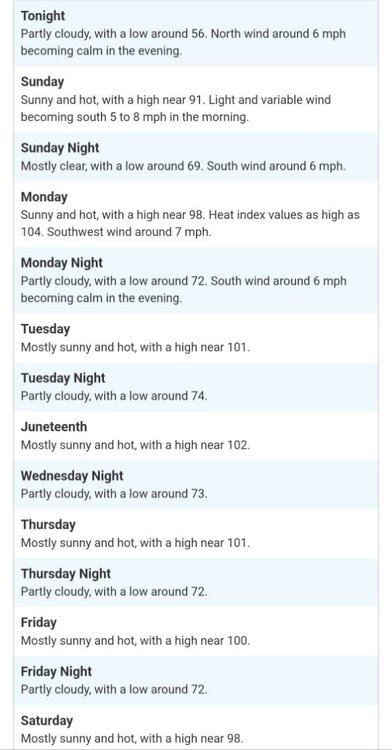
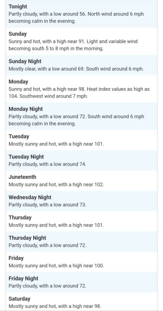
Latest forecast for Pittsburgh. Sent from my SM-G991U using Tapatalk