

SnoSki14
-
Posts
14,541 -
Joined
-
Last visited
Content Type
Profiles
Blogs
Forums
American Weather
Media Demo
Store
Gallery
Posts posted by SnoSki14
-
-
47 minutes ago, qg_omega said:
Few saw this coming

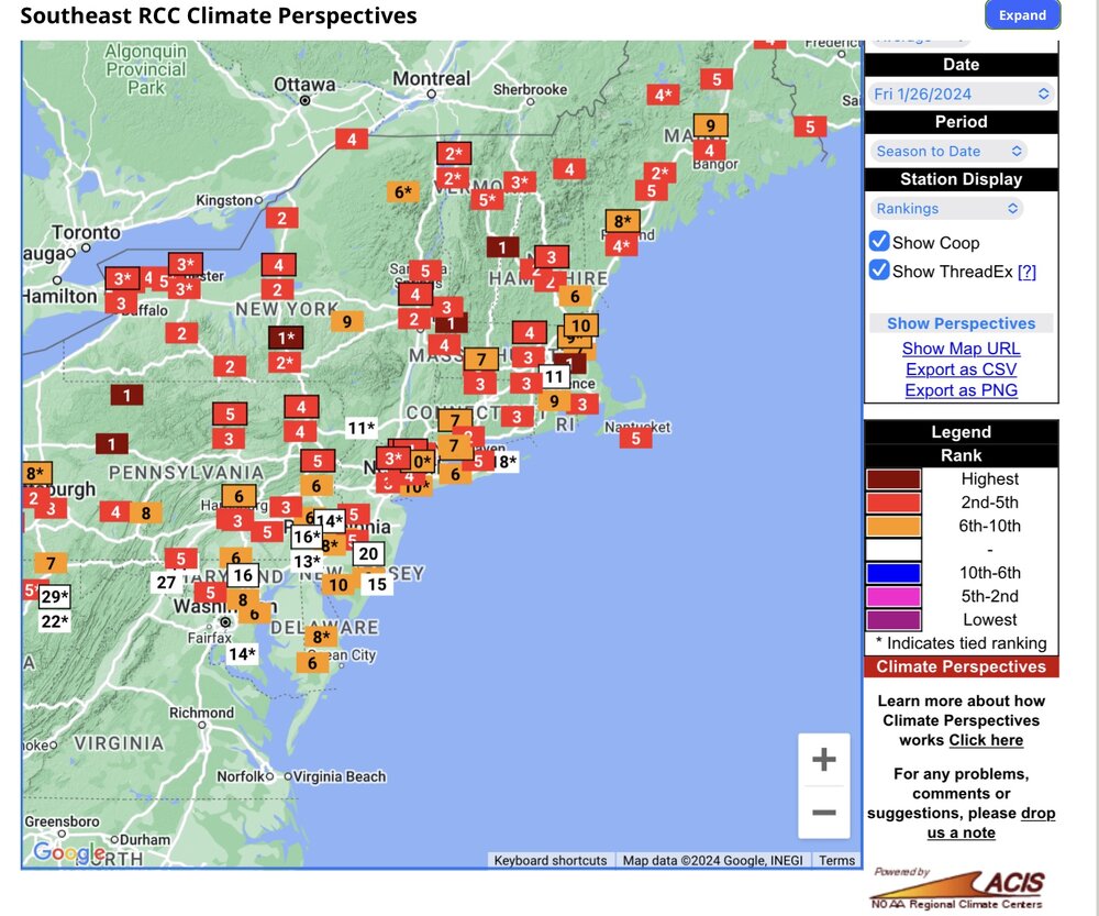
I mean the rate of warming is undeniable. It's also becoming normalized.
People thought December wasn't that warm because it wasn't like 2015.
Ok but it was still #2-3 all time. Sorry it didn't have +15 departures
-
 3
3
-
-
48 minutes ago, bluewave said:
Another winter with top 5 and top 10 warmth around the region to date.

It's scary how normalized this has become.
I feel like summer is a ticking time bomb for us.
-
1
-
-
4 minutes ago, Allsnow said:
None of the storms this year had a huge ULL sitting over us
If that's even the case
-
 1
1
-
-
13 minutes ago, Allsnow said:
Cold next weekend? All we got
Feb 4-5 looks more interesting than I thought. It's worth keeping an eye on.
There's definitely likely to be a southern stream storm but the evolution up here is what will be tricky to figure out.
Of course it also wouldn't shock me if the Carolinas or even further south ended up getting more snow than us so far with that system.
-
2
-
 1
1
-
-
Really unorthodox setup next week. Not sure how that's gonna play out.
Funky setup nonetheless
-
1
-
1
-
-
13 minutes ago, MJO812 said:
Why do you only post about rain and warmth ? Weird.
Troll, don't feed
-
2
-
 2
2
-
-
8 minutes ago, George001 said:
I hope they all rain down there in the tropics
They probably have better odds of seeing snow than you do in the coming pattern.
72-73 was one of the analogs for this winter
-
1
-
-
27 minutes ago, MJO812 said:
LOL
2 weeks go out to Feb 10. There's a rain event this weekend and not much else afterwards.
So I'm not wrong
-
The definition of a blah, boring pattern next 2 weeks.
Temps a bit above normal, a lot of cloudy, murky days, very early March like which sucks.
-
1
-
 1
1
-
3
-
-
2nd half of Feb is definitely workable.
-
3 hours ago, snowman19 said:
Like you said, God awful setup. Not even worth listing all the negatives. There’s going to be a lot of disapppointed people here, north and west of NYC included. Nothing is good about this storm if you want snow and I’m not saying that because I’m trolling or being a mean person or trying to take away people’s snow.
Word to the wise DO NOT use 10:1 ratio snowmaps with this event. They are going to be so grossly inaccurate it’s not going to be funny. Use the positive snow depth change maps only, if they aren’t available on Pivotal, use Kuchera. We will be lucky to see 5:1 ratios, even north and west of NYC
Yes we get it lol
-
1
-
1
-
-
Not surprised to see models back off the torch for the northeast to start Feb.
MJO 6/7 is not warm for us in a Nino for Feb. 7 is actually a colder signal. Still think we average slightly above normal but no 60s & 70s like some thought.
Even 50s may be difficult
-
1
-
-
56 minutes ago, MJO812 said:
The trend for the weekend storm has hern flatter.
Airmass is very poor. You'd need a strong dynamic system to pull in colder air.
Maybe a rain/snow mix towards the end, no accumulation
-
1
-
-
13 hours ago, BucksCO_PA said:
LOL, June, AUG & NOV were below average & SEPT was whopping 0.2 degrees warmer than normal.
There's absolutely no sense of objectivity from some of the warm mongers on this site.
Oh wow a few barely below normal months against the warmest 30 year averages vs an infinite number of top 5-10 warmest months over past decade
You really got us with that one.
-
42 minutes ago, Will - Rutgers said:
really bodes well for the future
i think you did great
We're just slowly roasting in that pot until it's too late
-
11 minutes ago, Allsnow said:

Euro is overdoing it. I don't see a strong cutter that will generate this kind of warmth. GFS will win out imo
-
What a dreary week coming up.
-
2
-
-
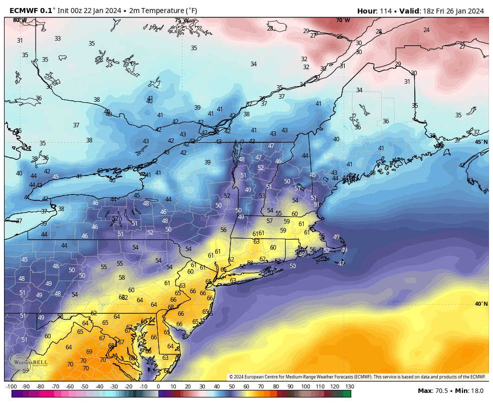
12 minutes ago, psv88 said:
We’re getting 60s this week?
Works for me. If it's not going to snow I prefer mild weather.
Unfortunately it looks like we'll have some rain/clouds with it though.
GFS does keep us on the colder side of the gradient though
-
1
-
-
27 minutes ago, Allsnow said:
Just saying that I didn’t read that tweet as him implying “possibly”…
Do I agree with it? No. I think we get one more week in late February and that will be it
We'll get opportunities for sure. I still think we could get at least one KU style storm a la 82/83 this winter.
Watching end of Jan with that PNA spike and then mid Feb with Nino climo + potential blocking setting up.
+PNA should be transient but ensembles have been trending more amplified with it which should cause more cold air in the east.
March is a wild card but could be active.
-
1
-
-
Significant PNA spike to end January prior to a warmer pattern.
I could see a storm there.
-
1
-
1
-
-
34 minutes ago, Allsnow said:
Webb was also calling for a big backloaded Nino winter…
on life support
I'm not sure. I actually think models could waffle quite rapidly over next few days. MJO wreaking havoc at the moment.
-
2
-
-
15 hours ago, 40/70 Benchmark said:
It will probably cause a milder stretch, but it doesn't necessarily mean the whole month of February is gone. I would be suprised.
This is not a typical Nino response. We might get skunked again
-
1
-
-
So everything is closed for an inch of snow lol. How embarrassing
Models trending south and drier.
-
1
-
-
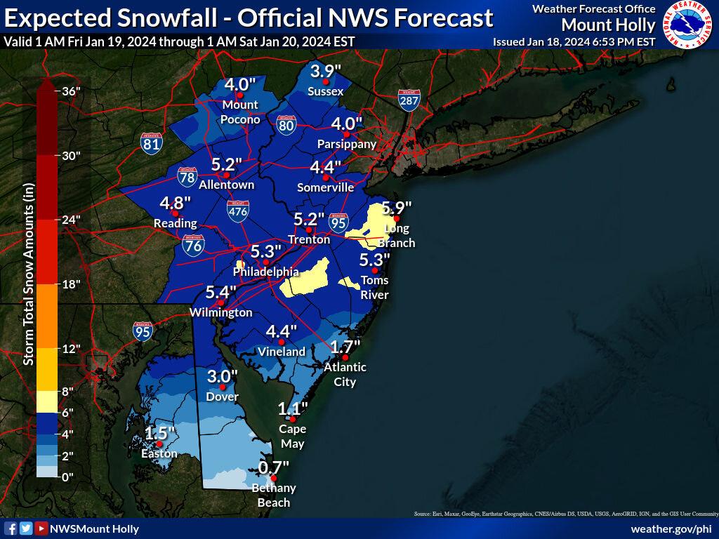
11 minutes ago, Franklin0529 said:
What is making mt holly stick with this? No model shows this

Ratios would have to be like 1:20 or greater based on what models show.
It's bizarre and I'm seeing schools shutting down left & right already.
-
 1
1
-

January 2024
in New York City Metro
Posted
I feel like I haven't seen the sun in forever