SnoSki14
-
Posts
15,257 -
Joined
-
Last visited
Content Type
Profiles
Blogs
Forums
American Weather
Media Demo
Store
Gallery
Posts posted by SnoSki14
-
-
SE ridge linking with blocking on Euro...same ole song and dance.
My 2-4" by the 20th is looking great
Actually think there's a good window late Feb into 1st week of March. Blocking gets situated and less western troughiness
-
 2
2
-
 1
1
-
 2
2
-
 2
2
-
-
I wouldn't be surprised if we ended up in a screw zone with systems prior to Feb 10 being north of us and post 10th south of us.
-
 1
1
-
 1
1
-
 2
2
-
-
Just now, Allsnow said:
Does that include the inch that fell last night?
No. This will be from Feb 5-20
-
 2
2
-
 1
1
-
-
Just now, Allsnow said:
Sounds good. Come back after the 13th to let us know how it worked out
Sure we'll see what happens between now and Feb 20.
My prediction is 2-4" total for NYC south
-
 1
1
-
 1
1
-
 2
2
-
 1
1
-
-
1 minute ago, Allsnow said:
Cool
Just think we get mostly slop. Models trended stronger with SE ridge for the 11-13th too hence the snow/mix to rain the Euro shows.
This is a SNE snow pattern to me and I'll stand by it
-
 1
1
-
 2
2
-
 1
1
-
-
-
4 minutes ago, Allsnow said:
AI is colder for Wednesday night and still has the thump for Saturday night
It's very early but think the 12-13th has the best potential to deliver something of substance aka more than 1-2" of slop.
-
 1
1
-
-
1 minute ago, Allsnow said:
Euro Ai has a decent front end Wednesday night and a good thump Saturday night.
Best case scenario that we could hope for.
-
2 minutes ago, Allsnow said:
IMO
The prime time will be from Super Bowl Sunday till Presidents’ Day. Then we will be In suppression city with very cold weather
Not necessarily. The SE ridge will keep fighting back as it does in Nina Febs.
We could use some luck with where the gradient sets up.
-
 1
1
-
-
Just now, MJO812 said:
Euro just came alot further south for the 9th from 0z. I do think that will be snow to rain down here .
A slopfest is possible for sure. Better chance for more frozen with the 9th system however only a slight north trend would lead to mainly rain
-
1 minute ago, NEG NAO said:
the 2 chances of accumulating snow we thought we had a good chance of the 6th and the 9th is mainly liquid now -
Yup we're kicking that can. That's why we can't buy into colorful maps.
-
 2
2
-
-
1 minute ago, Monmouth_County_Jacpot said:
Wait I thought winter was over? Quite a few had it cancelled on January 29th. Lol
So far I'm seeing a bunch of pretty maps and no results. We'll see what happens in a few weeks.
I continue to believe the boundary ends up further north. Great pattern for SNE points north.
-
 1
1
-
-
1 minute ago, Allsnow said:
Definitely
first shot is this weekend imo. Then we see what happens around the 12/13th
Watch us end up in a screw zone with earlier systems targeting SNE & north and mid Feb systems favoring southern areas due to TPV suppression.
That's kind of what the Euro shows
-
 4
4
-
-
33 minutes ago, Allsnow said:
Huge ridge bridge block on the op euro
There's definitely some promising developments but we need to see actual hits.
Day 10+ maps are pretty to look at but we need results.
So focus on one system at a time. Looking to see if we can score anything tonight and then midweek.
-
 5
5
-
-
11 minutes ago, Allsnow said:
Still plenty of chances coming with that block established at the end of the run
GEFS with much stronger Arctic blocking
The window is after next weekend if anything is going to happen of consequence
-
 2
2
-
-
8 minutes ago, MJO812 said:
LOL
CMC on the other hand is looking better. We'll see which way the Euro trends.
-
28 minutes ago, Allsnow said:
Start and mjo Cold phases should give us a below avg 2nd half of the month. I’m just worried about suppression if that happens
Oh it will don't worry. Zero expectations this month.
GFS OP looking less favorable already too
-
 1
1
-
-
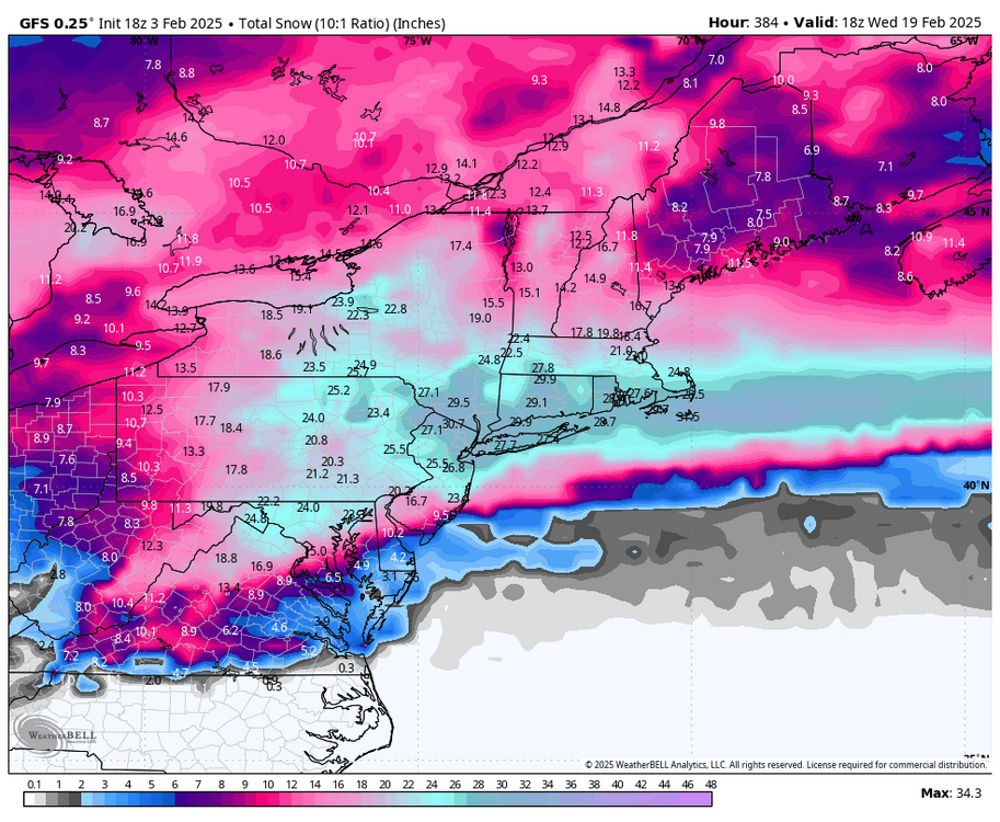
Looks like a lot of slop before a potentially more favorable snow window in mid Feb.
Euro with the passage into MJO 8 shows why it's better with the blocking
-
 3
3
-
-
27 minutes ago, Allsnow said:
EPS snow mean now 11 inches for NYC
the highest it has been all season
Yeah it actually doesn't look cold/dry once blocking gets going.
It would still be nice to score something before mid Feb though
-
 5
5
-
-
2 minutes ago, RU848789 said:
As I just said elsewhere, who hacked the GFS? Fess up, lol...
It ends with massive arctic and Greenland blocking sending arctic air into the US lol
-
 1
1
-
-
-
Would be nice if the GFS had a clue.
-
 1
1
-
-
7 minutes ago, 40/70 Benchmark said:
Looking at things, this upcoming splits kind of looks like Feb 2018.
So March 2018 coming up?
-


Discussion-OBS Weekend Feb 8-9 Another mainly 12 hour snow-ice event possibly changing to rain before ending Sunday. NYC-LI-S of I78 on the edge?
in New York City Metro
Posted
Which is probably not great. We want a strong thump. Weaker precip won't help