

SnoSki14
-
Posts
14,533 -
Joined
-
Last visited
Content Type
Profiles
Blogs
Forums
American Weather
Media Demo
Store
Gallery
Posts posted by SnoSki14
-
-
5 minutes ago, Allsnow said:
I might end up with 10 at this rate
Yeah this is pretty nuts. There's going to be a lot of surprised people this morning.
-
 1
1
-
-
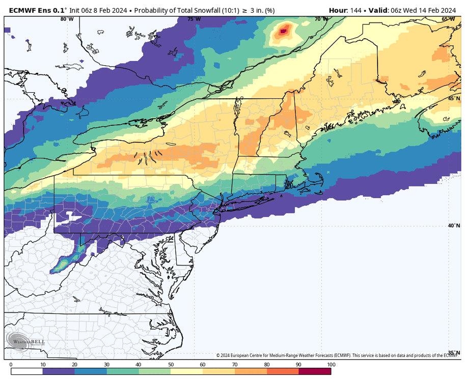
Winter storm warning in Somerset.
That band is something else. This will easily outperform the last event for my area near New B
-
2
-
-
4 minutes ago, the_other_guy said:
It is 40 right now in CPK. I love your optimism, but it will take a while to cool down tonight in city
Not with those dews
-
1
-
-
1 hour ago, winterwx21 said:
Glad to see this trended our way on the 12z models. 2 to 4 looks like a good call for most now. WWA for my area and as others have said, it'll likely be expanded north this afternoon.
3-5" is looking more possible actually and someone's gonna hit 6" or more in that band.
-
3
-
-
2-4" looks good for central NJ.
Would be a nice little event.
-
5
-
-
I told y'all it was gonna snow and stay south.
-
4
-
 1
1
-
 1
1
-
-
1 minute ago, Northof78 said:
The bigger risk now is this south/suppression/flat trend continues, not too far north..need to see trend stop now
Nah I'm not concerned about that at all
-
6 minutes ago, Prismshine Productions said:
-PNA, +NAO... Ew

Sent from my SM-S146VL using Tapatalk
It's getting late in the season where the PNA loses its influence. -PNA is actually good in March.
-
1
-
-
Seeing the usually amped up Rgem & Nam south is a good sign.
Snowman loves his weenies lol
-
1
-
1
-
-
It's going to snow
-
1
-
-
This is not going to trend north sorry. I think we'll see a significant snow event.
-
6
-
-
2 hours ago, wishcast_hater said:
Now we have a tipping point? What nonsense, no one can honestly say what the earths temperature SHOULD BE. There is over a 100 degree difference between Siberia and Death Valley but now people are claiming what the ideal temp SHOULD BE? Wow.
Science doesn't care what you think.
If people want to live in a fantasy world where everything is great then they can do so but the world will be affected either way.
And as far as fires go, humans may trigger them but droughts and high temperatures will exacerbate them.
-
2
-
2
-
-
2 minutes ago, brooklynwx99 said:
GFS/ECMWF and ensembles vs CMC and UKMET. lol
As long as it doesn't get sheared out then parts of the region could do well.
An amplifying storm and the squeeze play with confluence could yield some high totals otherwise.
-
2
-
-
1 hour ago, WinterWolf said:
We wait and watch…we know where these correct some towards the end. I like our spots right now.
Not with that confluence up north. This either produces further south or ends up getting shredded completely.
-
5 minutes ago, brooklynwx99 said:
kinda nuts comparing to 06z. huge shift from a normally stable model. makes sense given the early phasing solution got thrown out
Confluence trends don't typically just stop once they start. More south shifts are possible.
-
3 hours ago, ChescoWx said:
CNBC reports that “ The world surpasses key warming threshold [+1.5°C] across an entire year for the first time!!! Ruh roh...let's all tremble in our boots.... but of course with that threshold crossed it not surprisingly delivered absolutely nothing catastrophic or life threatening to our planet. Now we used to hear that +1.5°C above the 1850-1900 pre-industrial average temps would be the scary “tipping point.” Me thinks the climate alarmists will need to push that baby back to maybe +2.0°C or surely 2.1 °C. That cataclysmic "tipping point" will most surely happen at that point.....right????
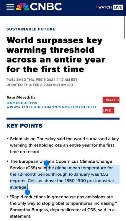
2C is the tipping point but you'd be a fool to think horrific events already hadn't transpired.
Billions in damages, millions of acres burned, catastrophic flooding & fires, devastating heat waves, crawl out from under your rock.
-
1
-
2
-
-
Just now, Franklin0529 said:
I still think it's a light event. Airmass is terrible
It's really not that bad. Cold air rapidly filters in as this phases.
How much phasing occurs is key. A weaker storm won't help.
-
1
-
-
3 hours ago, snowman19 said:
Mon-Tues is going to move north again
Because you said so lol
-
1
-
-
2 minutes ago, Franklin0529 said:
Everyone afraid of snowman's weenies an Debbie downer talk. It still looks good. Curious to see eps if it moves south or what
I would love for this to be a snow bomb just to humiliate his weenie behind
-
 1
1
-
2
-
-
Just now, MJO812 said:
Look at the gfs lol
Mid-Atlantic is probably a more favored region than New England in a Nino blocking regime.
NAO won't be particularly strong though so we should avoid Feb 2010 type suppression.
-
1
-
-
EPS had higher heights out west near the Rockies by Feb 15th. Hopefully that continues
We should see opportunities from mid Feb through mid March. No guarantees of course but greater chances than usual.
-
2
-
-
6 minutes ago, MJO812 said:
That's what I have been saying. I don't believe these inland runners.
I don't either. Confluence is strengthening on ensembles.
And no amount of weenies by snowman will change that
Problem is it's still a marginal setup. Amped solutions represent some phasing which is needed to bring cold air down.
We could end up with a less dynamic system to our south that still ends up being rain.
-
1
-
1
-
-
11 minutes ago, MJO812 said:
Euro is slightly south than 12z
Gfs is even south of 0z
South trend is more likely. AO is tanking
-
1
-
1
-
-
1 minute ago, ineedsnow said:
6z GFS is south and meh
I think a south trend is likely here. That AO is tanking
-
1
-
1
-

Refresher snow & obs between ~midnight and Noon Sat Feb 17 2024
in New York City Metro
Posted
Crazy positive bust. Gotta be like 10" out there.