

Lightning
-
Posts
1,182 -
Joined
Content Type
Profiles
Blogs
Forums
American Weather
Media Demo
Store
Gallery
Everything posted by Lightning
-
Love it
-
If it performs like the last heat wave I will love it. Ring of fire gets going and the temps don't make it as far east as projected.
-
40s expected here tonight. Frost advisory up there
-

2023 Short/Medium Range Severe Weather Discussion
Lightning replied to Chicago Storm's topic in Lakes/Ohio Valley
Had that happen to me before chasing. Now I just stay home unless I chase storms several miles away that clearly will not hit MBY. Yes the thunders were house shaking. Several friends and neighbors have commented about it. 2 nights in a row of lack of sleep. Sorry if my typing is a bit out of sorts. Very tired as it has been a long few days. And I am still 100%on my phone. Hopefully they will fix the multiple power lines down (can't wait to send pics) tomorrow. -
2023 Short/Medium Range Severe Weather Discussion
Lightning replied to Chicago Storm's topic in Lakes/Ohio Valley
The was cell on top of us we had very strong winds southerly in nature and then the line coming in in from the west northwest merged things swirled and northerly strong winds. When they merged on us the winds came from various directions. Looking around the is a very distinct path about a 1/4 mile long of damage running ENE. Tree damage is multidirectional in this area. Today we finished cleaning up all the mess. Burned a ton of leaves, branches and wood. -
2023 Short/Medium Range Severe Weather Discussion
Lightning replied to Chicago Storm's topic in Lakes/Ohio Valley
Awesome thanks for this!!! -
2023 Short/Medium Range Severe Weather Discussion
Lightning replied to Chicago Storm's topic in Lakes/Ohio Valley
If you look up Spicers Cider Mill on Clyde Rd. I live a bit NE of it. We spent all day cleaning up. Still have some work to do tomorrow. When I can get back online (not on my phone) I will post some pictures. -
2023 Short/Medium Range Severe Weather Discussion
Lightning replied to Chicago Storm's topic in Lakes/Ohio Valley
We are wondering if there was a funnel or small tornado came through. Damage is not uniform / similar direction. Some areas it is one direction other areas different direction. There looks like a path as some houses on the lake are not even touched even though they have willows and cottonwood trees (no damage at all) while we have maples that are 1/2 gone now a willow that was leveled by us. Likely will not get power back until Sunday at the earliest. AT&T tower is out so me cell service is sporadic (no sure when this will even post). -
2023 Short/Medium Range Severe Weather Discussion
Lightning replied to Chicago Storm's topic in Lakes/Ohio Valley
Yeah. That happened to me earlier this year when there was a tornado warning and I wasn't home but my family was. You feel helpless -
2023 Short/Medium Range Severe Weather Discussion
Lightning replied to Chicago Storm's topic in Lakes/Ohio Valley
That was one intense storm. Large tree branches down all over the place. Lost power as I watched one of the branches take out the power lines at my neighbor's house (100' away from my house). Watched my kayak and paddle board fly up in the air and into the lake. Power of mother nature is just awesome. Tomorrow is going to be a big clean up day!!! I'll need to find my kayak and paddle board. . Thankfully I have plenty of gas for the generator. -
Well made it to 83.3F. Warmest day of this heat wave
-
2023 Short/Medium Range Severe Weather Discussion
Lightning replied to Chicago Storm's topic in Lakes/Ohio Valley
There we go. Lower MI Severe Storm Watch -
Hey the warm front is here!!! I might finally get above 82F.
-
2023 Short/Medium Range Severe Weather Discussion
Lightning replied to Chicago Storm's topic in Lakes/Ohio Valley
WI and LM ... Sadly not Lower MI yet -
I was on the northern up edge. I could tell many cells were basically initiating right over head. I got several 10 second huge rain drop downpours tons of brilliant CC lightning overhead but only ended up with a bit over an 1" of rain. I would have loved to have gotten that that 7.36" total. So close but yet so far . It was definitely enjoyable last night
-
2023 Short/Medium Range Severe Weather Discussion
Lightning replied to Chicago Storm's topic in Lakes/Ohio Valley
Love this weather!! Feels great to me. Yep as expected the sun is pushing into southern MI mostly SW MI and extreme SE MI. As SPC points out: Visible satellite imagery has shown significant erosion of the stratus across southwest Lower MI as the differential heating zone becomes an effective warm front amid strong southwesterly surface winds. Dewpoints are now in the upper 70s with temperatures in the upper 80s/low 90s across southwest Lower MI. Temperatures are still in the upper 70s/low 80s farther north and east, with lower dewpoints there as well. Even with the more moist and warmer conditions, some convective inhibition currently still remains across southwest Lower MI, evidenced by the billow clouds on visible imagery. Additional heating, coupled with low-level moisture convergence over the region, may be able to overcome this convective inhibition, promoting warm-sector thunderstorm development. There is some uncertainty regarding this scenario, but any warm-sector storms that do form would likely be supercellular and capable of all severe hazards, including tornadoes. -
2023 Short/Medium Range Severe Weather Discussion
Lightning replied to Chicago Storm's topic in Lakes/Ohio Valley
Firing east of Ludington now -
2023 Short/Medium Range Severe Weather Discussion
Lightning replied to Chicago Storm's topic in Lakes/Ohio Valley
Looking back this particular run by the HRRR was pretty darn close (of course not perfect) to what happened -
2023 Short/Medium Range Severe Weather Discussion
Lightning replied to Chicago Storm's topic in Lakes/Ohio Valley
One concern I have is the cloud cover is not burning off very fast at all. Most of southern MI is still cloudy and it is 3PM. I was hoping the sun would be out a bit more by now across southern MI. -
2023 Short/Medium Range Severe Weather Discussion
Lightning replied to Chicago Storm's topic in Lakes/Ohio Valley
SPC upgrade the tornado to 5% for this area: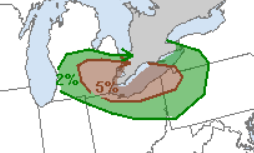
-
2023 Short/Medium Range Severe Weather Discussion
Lightning replied to Chicago Storm's topic in Lakes/Ohio Valley
If you get a chance watch the satellite loop. Interesting/fun to see the holes opening up so rapidly.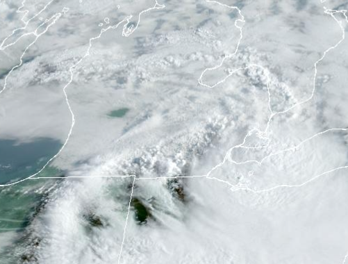
-
Got an 1". Area just (couple miles) to my south got 2-6" with some flooding but I didn't see any significant on my way to work (just some large yard puddles and ditch flooding).
-
2023 Short/Medium Range Severe Weather Discussion
Lightning replied to Chicago Storm's topic in Lakes/Ohio Valley
Last night was definitely modeled better than the previous night. I think it has to do with the storms were already ongoing last night while the night before the most of the models were too quick to develop convection making an MCS in MI that just didn't occur. -
2023 Short/Medium Range Severe Weather Discussion
Lightning replied to Chicago Storm's topic in Lakes/Ohio Valley
I really like the set up going into this week. This is the perfect set up for prolific rain totals. Little bummed MBY somehow only got 1" while most surrounding areas got 2-6" as DTX warning mentions. A 10" rain event would be incredible. As it is 6" is a ton of rain!! It is going to be interesting to see how the rest of today goes as right now the radar is still firing some stuff up. -
Looks like you in Columbus got more than I did out it. Ended up with 1.04" according to my rain gauge. Heaviest rains were just to my south by just a few miles. Hartland (I am just north of Hartland), Brighton to Milford area likely got 3-5". Lightning was nonstop strobe light for good 3 hours. Had about 4 good strikes around MBY with the initial couple cells that went though. The CG shifted south with the heavier rains unfortunately. It was nice to at least get something.

