Hurricane Agnes
-
Posts
8,579 -
Joined
Content Type
Profiles
Blogs
Forums
American Weather
Media Demo
Store
Gallery
Everything posted by Hurricane Agnes
-
Jan 12-13 Snow Event Obs and discussion
Hurricane Agnes replied to ChescoWx's topic in Philadelphia Region
Yup. Mt. Holly expanded the WSW into Cape May and Atlantic Counties (except the immediate coast). They don't expect the mixing to continue that long. -
Jan 12-13 Snow Event Obs and discussion
Hurricane Agnes replied to ChescoWx's topic in Philadelphia Region
Mt. Holly hasn't posted any PNSs yet although I don't know how much of a priority they are with whatever furlough protocol they have. -
Jan 12-13 Snow Event Obs and discussion
Hurricane Agnes replied to ChescoWx's topic in Philadelphia Region
I think because there was a chance for a Miller B setup although how much of that precipitation is able to get up this far with that high to the north suppressing stuff, is up for debate. The OH valley low is still sitting over southern KY/northern TN but I'm now seeing a low forming off the coast of SC on a surface map. What that coastal does will determine how much of a round 2 we might see up this far! -
Jan 12-13 Snow Event Obs and discussion
Hurricane Agnes replied to ChescoWx's topic in Philadelphia Region
Sky is brightening a bit and still getting some light flurries but round 1 is pretty much done. Calling it at 1.25" with a temp of 26. Dp was in the 20s during the snow but has dropped back down to 17 now so dry air is advecting in. -
Jan 12-13 Snow Event Obs and discussion
Hurricane Agnes replied to ChescoWx's topic in Philadelphia Region
I thought this was supposed to go on and off the rest of today (i.e., "long duration")? There would probably be a lull/dry slot until the coastal gets established. I expect that folks far north may be done but there might be some more via a round 2 later for folks further south. Currently SN- here and temp is 26. -
Jan 12-13 Snow Event Obs and discussion
Hurricane Agnes replied to ChescoWx's topic in Philadelphia Region
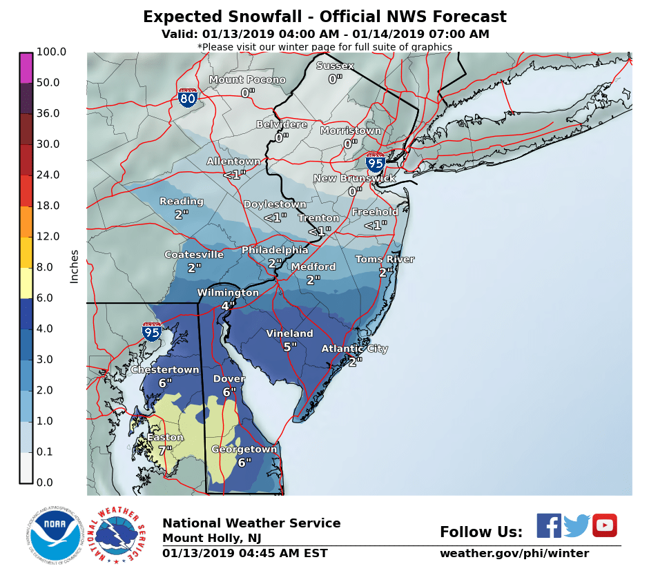
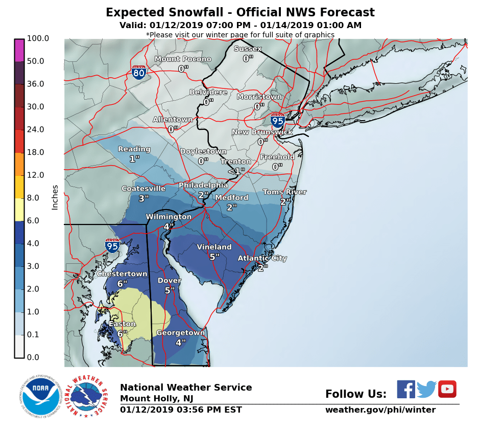
Most recent Mt. Holly snow map -
-
Jan 12-13 Snow Event Obs and discussion
Hurricane Agnes replied to ChescoWx's topic in Philadelphia Region
Have about an 1" this morning so far with steady light snow (very fine flakes) and fog. Current temp is 26 with dp 21. Looks like a bit of a dry slot is heading this way with a small band behind it. -
Jan 12-13 Snow Event Obs and discussion
Hurricane Agnes replied to ChescoWx's topic in Philadelphia Region
Squirrel perch in progress! -
Jan 12-13 Snow Event Obs and discussion
Hurricane Agnes replied to ChescoWx's topic in Philadelphia Region
Now have light snow. Cars getting the sugar dusting. Temp continuing to fall and now down to 30. Dp was still hanging in the 15/16 range but may start moving higher soon. ETA, dp moved up briefly to 17 so I think it is on its way to moistening the atmosphere (or it's my humidifiers going full blast ). -
Jan 12-13 Snow Event Obs and discussion
Hurricane Agnes replied to ChescoWx's topic in Philadelphia Region
I didn't look at their earlier high/low prob maps. But trying to predict the cutoff is gonna be difficult in any case. I've been literally watching the battle of air masses going on overhead here - stuff tries to push in from the west, high from the north/northeast noses in and shears it away! Just checked outside for the millionth time and I am now finally getting some flakes. At least they are not microflakes. -
Jan 12-13 Snow Event Obs and discussion
Hurricane Agnes replied to ChescoWx's topic in Philadelphia Region
Updated snow map from Mt. Holly... Ralph (Steve) is now on board with > 0"!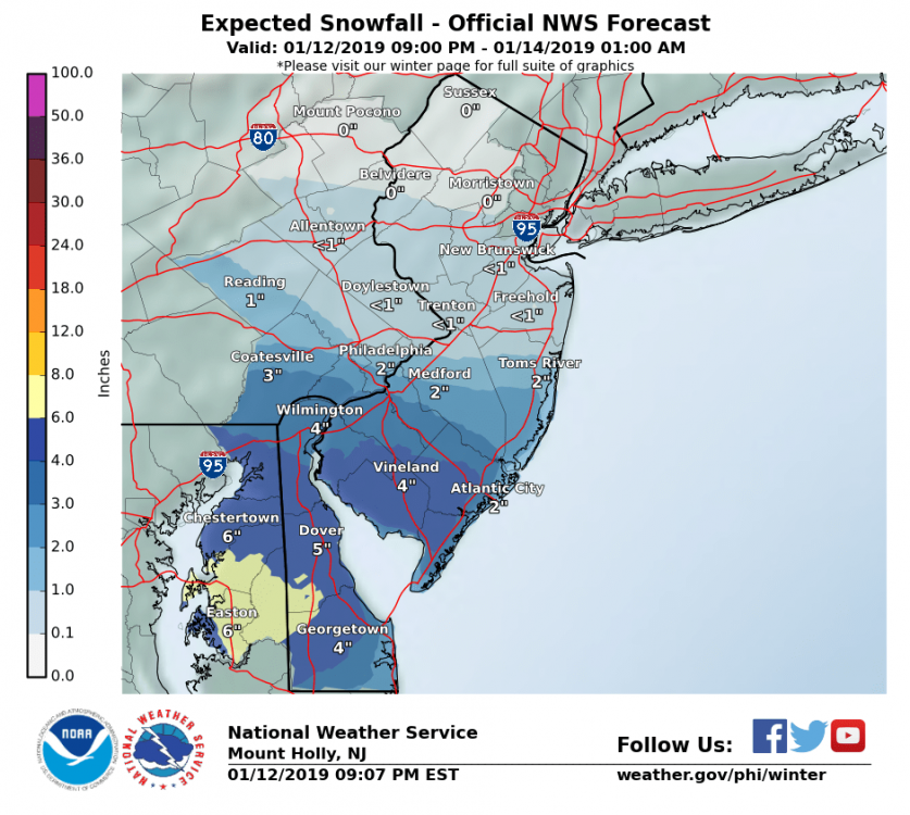
-
Jan 12-13 Snow Event Obs and discussion
Hurricane Agnes replied to ChescoWx's topic in Philadelphia Region
-
Jan 12-13 Snow Event Obs and discussion
Hurricane Agnes replied to ChescoWx's topic in Philadelphia Region
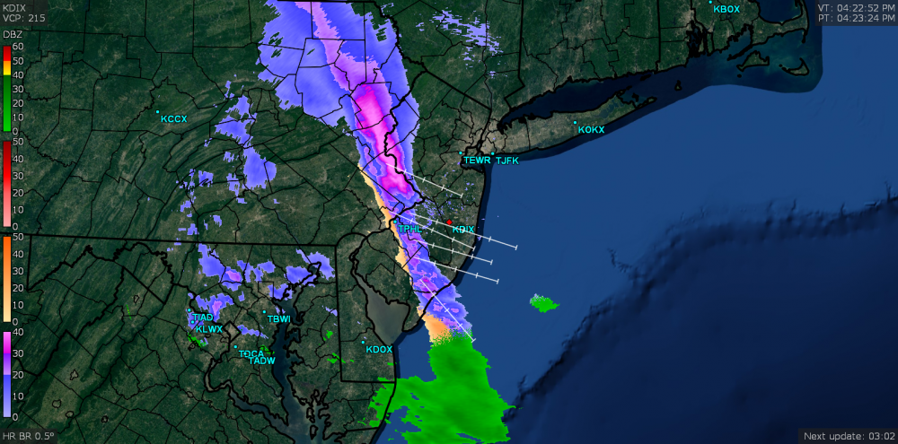
Still no flakes here. Watched the radar go from good potential to washout in 10 minutes! In other news, the temp is slowly creeping down... Down to 31 with dp hanging on at 15. (ETA @9:30 pm another image - that shear line is wild)!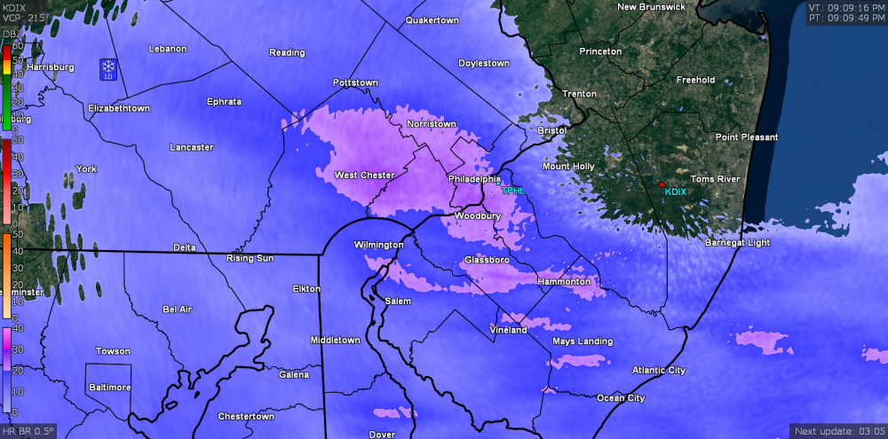

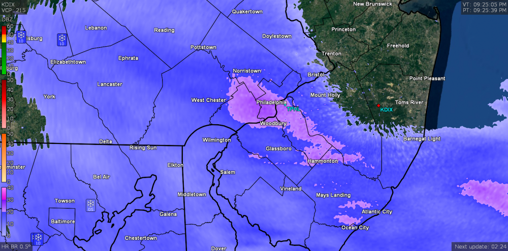
-
Jan 12-13 Snow Event Obs and discussion
Hurricane Agnes replied to ChescoWx's topic in Philadelphia Region
My sis in Wyndmoor just texted that she is getting some snow. She is a couple miles NW of me. I still have virga but I think that is about to change shortly. -
Jan 12-13 Snow Event Obs and discussion
Hurricane Agnes replied to ChescoWx's topic in Philadelphia Region
Looks like a blob of something that might make it to the ground is incoming... When I animated it, it was moving due east.
-
Jan 12-13 Snow Event Obs and discussion
Hurricane Agnes replied to ChescoWx's topic in Philadelphia Region
Saw they updated with another map after the one I posted earlier...
-
Jan 12-13 Snow Event Obs and discussion
Hurricane Agnes replied to ChescoWx's topic in Philadelphia Region
Interesting but after a low of 20 this morning, the temp has been generally hanging around freezing +/- 1 once it hit the high. Currently 32 (dp has been hanging around 15 much of the day) where the high was 33 ~3 pm. Not "seeing" any flakage as the line is literally just starting to move overhead, but standing outside you can kind of feel something hitting your face.... like snizzle. -
Jan 12-13 Snow Event Obs and discussion
Hurricane Agnes replied to ChescoWx's topic in Philadelphia Region
Mt. Holly threw up a WWA a layer of counties north (including Philly proper) - URGENT - WINTER WEATHER MESSAGE National Weather Service Mount Holly NJ 317 PM EST Sat Jan 12 2019 NJZ017>020-026-027-PAZ070-071-101-102-131100- /O.EXB.KPHI.WW.Y.0002.190113T0000Z-190114T0600Z/ Gloucester-Camden-Northwestern Burlington-Ocean-Coastal Ocean- Southeastern Burlington-Delaware-Philadelphia-Western Chester- Eastern Chester- Including the cities of Glassboro, Camden, Cherry Hill, Moorestown, Mount Holly, Jackson, Long Beach Island, Wharton State Forest, Media, Philadelphia, Honey Brook, Oxford, West Chester, and Kennett Square 317 PM EST Sat Jan 12 2019 ...WINTER WEATHER ADVISORY IN EFFECT FROM 7 PM THIS EVENING TO 1 AM EST MONDAY... * WHAT...Snow expected. Total snow accumulations of 2 to 3. * WHERE...Portions of southern New Jersey and southeast Pennsylvania. * WHEN...From 7 PM this evening to 1 AM EST Monday. * ADDITIONAL DETAILS...Plan on slippery road conditions. PRECAUTIONARY/PREPAREDNESS ACTIONS... A Winter Weather Advisory for snow means periods of snow will cause primarily travel difficulties. Expect snow covered roads and limited visibilities, and use caution while driving. The latest road conditions for the state you are calling from can be obtained by calling 5 1 1. && $$
-
E PA/NJ/DE Winter 2018-19 OBS Thread
Hurricane Agnes replied to Rtd208's topic in Philadelphia Region
One of my favorite shows! As cold as it was this morning, that guy had to be numb (although those trucks do come with tops but i guess he wanted to show off the gun turret). lol -
Jan 12-13 Snow Event Obs and discussion
Hurricane Agnes replied to ChescoWx's topic in Philadelphia Region
People are still reading what Ji writes? Slightly updated Mt. Holly snow map -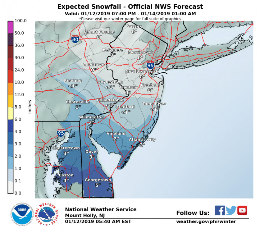
-
E PA/NJ/DE Winter 2018-19 OBS Thread
Hurricane Agnes replied to Rtd208's topic in Philadelphia Region
Yeah I have been past there. Whenever they used to have the reservist monthly practices, a convoy of copters used to fly overhead on their way from and back there. They don't use those jeeps anymore. Hummers (HMMWVs) rule the day (although they are trying to replace them all)! -
Jan 12-13 Snow Event Obs and discussion
Hurricane Agnes replied to ChescoWx's topic in Philadelphia Region
Low here this morning was 20. DP has been in the single digits (currently 8) and has been driving my humidifiers crazy! lol Currently 24 and partly cloudy. Will be interesting how much sheering will happens later today and overnight. -
E PA/NJ/DE Winter 2018-19 OBS Thread
Hurricane Agnes replied to Rtd208's topic in Philadelphia Region
Da fuq? Looks like he may be going to some club event (there are guys who are military vehicle collectors and that may be from the Vietnam war era). -
E PA/NJ/DE Winter 2018-19 OBS Thread
Hurricane Agnes replied to Rtd208's topic in Philadelphia Region
Have gotten 0.09" of rain so far overnight and the temp has stayed just above freezing so far since midnight here and is currently 33. Not seeing any pingers or flakes but am getting some light drizzle. -
E PA/NJ/DE Winter 2018-19 OBS Thread
Hurricane Agnes replied to Rtd208's topic in Philadelphia Region
Just got in from my sister's house in Wyndmoor. Pingers galore with some snow mixed in. It had the nerve to be trying to accumulate although I know the line is almost through the area. Current temp here is 33 with a mix of sleet & snow flakes.