Hurricane Agnes
-
Posts
8,581 -
Joined
Content Type
Profiles
Blogs
Forums
American Weather
Media Demo
Store
Gallery
Everything posted by Hurricane Agnes
-
1st Winter Event of 2018-19 Fall/Winter Season
Hurricane Agnes replied to ChescoWx's topic in Philadelphia Region
It has been raining all night and even had a downpour of > 1"/hr. The temp had risen overnight to 39 just before 4am but has started dropping again. Currently 36, with moderate rain and windy. -
1st Winter Event of 2018-19 Fall/Winter Season
Hurricane Agnes replied to ChescoWx's topic in Philadelphia Region
I remember the winter of the ice storms ('93 - '94) when folks were reminded that the state routes like 202/309, etc are considered "secondary roads" to PennDOT. The "primary" roads are I-95, I-76, I-80, etc. -
1st Winter Event of 2018-19 Fall/Winter Season
Hurricane Agnes replied to ChescoWx's topic in Philadelphia Region
I think along the coast it was rain but generally 2 - almost 9" (wow). I got a bit over 4" here in NW Philly. Updated PNS here - NOUS41 KPHI 152319 PNSPHI DEZ001>004-MDZ008-012-015-019-020-NJZ001-007>010-012>027-PAZ054-055- 060>062-067>071-161119- Public Information Statement Spotter Reports National Weather Service Mount Holly NJ 619 PM EST Thu Nov 15 2018 The following are unofficial observations taken during the past 14 hours for the storm that has been affecting our region. Appreciation is extended to highway departments, cooperative observers, Skywarn spotters and media for these reports. This summary also is available on our home page at weather.gov/phi ********************STORM TOTAL SNOWFALL******************** LOCATION STORM TOTAL TIME/DATE COMMENTS SNOWFALL OF /INCHES/ MEASUREMENT DELAWARE ...New Castle County... 2 S Newark 4.5 217 PM 11/15 CoCoRaHS Newark 4.3 201 PM 11/15 Trained Spotter Bear 4.0 249 PM 11/15 Trained Spotter Hockessin 3.6 434 PM 11/15 Trained Spotter New Castle County Ai 2.5 100 PM 11/15 ASOS MARYLAND ...Cecil County... Port Deposit 4.0 214 PM 11/15 Trained Spotter 5 NW Elkton 2.7 100 PM 11/15 CoCoRaHS North East 0.5 103 PM 11/15 Trained Spotter NEW JERSEY ...Atlantic County... Estell Manor 0.4 1125 AM 11/15 Snow and sleet. ...Burlington County... Florence 4.2 552 PM 11/15 Trained Spotter Crosswicks 4.0 512 PM 11/15 Trained Spotter Medford 4.0 536 PM 11/15 Social Media Mount Laurel 3.8 245 PM 11/15 NWS Employee Bordentown 3.5 309 PM 11/15 Social Media Marlton 3.5 513 PM 11/15 Meteorologist Westampton Twp 3.2 200 PM 11/15 Meteorologist 1 ESE Westampton Twp 1.8 100 PM 11/15 Official NWS Obs Presidential Lakes 1.5 212 PM 11/15 Social Media Hainesport Twp 1.4 118 PM 11/15 Meteorologist 1 SW Hainesport Twp 1.4 115 PM 11/15 In past 3 hours Mount Holly 0.1 151 PM 11/15 NWS Employee ...Camden County... 1 E Merchantville 4.5 311 PM 11/15 Trained Spotter Somerdale 3.3 315 PM 11/15 Co-Op Observer Lindenwold 3.2 229 PM 11/15 Trained Spotter ...Gloucester County... West Deptford 3.5 345 PM 11/15 Trained Spotter 2 S Wenonah 3.5 126 PM 11/15 Trained Spotter Mantua Twp 3.5 340 PM 11/15 Social Media Washington Twp 3.3 145 PM 11/15 Trained Spotter Mullica Hill 3.0 120 PM 11/15 Trained Spotter Newfield 2.8 128 PM 11/15 Snow changing to sleet. Pitman 1.6 155 PM 11/15 Trained Spotter East Greenwich Twp 0.7 103 PM 11/15 Emergency Manager ...Hunterdon County... Lebanon 5.2 415 PM 11/15 Trained Spotter 2 S Clinton Twp 5.0 600 PM 11/15 Trained Spotter Readington Twp 4.8 519 PM 11/15 Still snowing. Flemington 4.5 400 PM 11/15 Trained Spotter 3 S East Amwell Twp 1.0 212 PM 11/15 In past 30 minutes. ...Mercer County... Princeton 4.0 409 PM 11/15 Broadcast Media Ewing Twp 4.0 415 PM 11/15 Trained Spotter Hamilton Twp 3.8 420 PM 11/15 Social Media East Windsor Twp 1.5 319 PM 11/15 Broadcast Media ...Middlesex County... Woodbridge Twp 5.0 541 PM 11/15 Social Media Edison 4.8 400 PM 11/15 Trained Spotter Old Bridge 4.0 504 PM 11/15 Social Media East Brunswick 4.0 600 PM 11/15 Trained Spotter New Brunswick 3.0 215 PM 11/15 Trained Spotter ...Monmouth County... 2 NNE West Freehold 3.2 300 PM 11/15 Trained Spotter Middletown 2.5 350 PM 11/15 Social Media Keyport 2.0 213 PM 11/15 Trained Spotter Matawan 2.0 234 PM 11/15 Social Media ...Morris County... Green Pond 5.0 540 PM 11/15 Trained Spotter ...Salem County... Carneys Point 3.0 108 PM 11/15 Public Pennsville 2.8 353 PM 11/15 Trained Spotter ...Somerset County... Somerset 6.0 541 PM 11/15 Trained Spotter Hillsborough Twp 5.0 539 PM 11/15 Trained Spotter Branchburg Twp 4.0 401 PM 11/15 Social Media Bernardsville 2.1 342 PM 11/15 Trained Spotter ...Sussex County... 4 SW Wantage 1.0 354 PM 11/15 NWS Employee ...Warren County... Hackettstown 6.2 515 PM 11/15 Trained Spotter 2 NNE Greenwich Twp 4.9 410 PM 11/15 Trained Spotter Frelinghuysen Twp 4.0 455 PM 11/15 Social Media PENNSYLVANIA ...Berks County... Reading 8.0 539 PM 11/15 Social Media Bernville 7.1 400 PM 11/15 Trained Spotter Hamburg 6.5 501 PM 11/15 Trained Spotter West Lawn 6.0 254 PM 11/15 Trained Spotter 1 NNE Earl Twp 6.0 400 PM 11/15 Trained Spotter 4 SW Reading 5.5 511 PM 11/15 CoCoRaHS Shillington 4.0 213 PM 11/15 Social Media ...Bucks County... Springtown 8.5 455 PM 11/15 Trained Spotter 2 SSW Buckingham Twp 5.2 525 PM 11/15 Trained Spotter Langhorne 5.2 519 PM 11/15 Trained Spotter Morrisville 5.0 211 PM 11/15 Trained Spotter 1 NNW Langhorne 4.5 350 PM 11/15 Trained Spotter Bensalem 4.5 338 PM 11/15 Trained Spotter Hilltown Twp 4.0 400 PM 11/15 NWS Employee 1 WNW Plumstead Twp 2.5 221 PM 11/15 Social Media ...Carbon County... Albrightsville 5.5 458 PM 11/15 Social Media ...Chester County... Elverson 5.4 423 PM 11/15 Trained Spotter Glenmoore 5.1 230 PM 11/15 Trained Spotter Malvern 5.0 245 PM 11/15 Trained Spotter West Chester 4.5 512 PM 11/15 Trained Spotter East Nantmeal Twp 4.0 201 PM 11/15 Social Media Exton 3.7 121 PM 11/15 Trained Spotter 1 WNW Berwyn 3.3 350 PM 11/15 CoCoRaHS 2 N East Marlborough 3.0 110 PM 11/15 Social Media ...Delaware County... Chadds Ford Twp 4.7 215 PM 11/15 Trained Spotter 1 SE Thornbury Twp 4.0 149 PM 11/15 Trained Spotter Drexel Hill 1.5 1206 PM 11/15 Social Media ...Lehigh County... 1 N Coopersburg 7.0 538 PM 11/15 Trained Spotter North Whitehall Twp 7.0 515 PM 11/15 Social Media Alburtis 6.5 545 PM 11/15 Trained Spotter 2 NE Ancient Oaks 6.5 500 PM 11/15 Trained Spotter 2 ENE Emmaus 6.1 415 PM 11/15 Trained Spotter 1 S Allentown 4.5 300 PM 11/15 Trained Spotter ...Montgomery County... 1 ESE Perkiomen Twp 5.3 500 PM 11/15 Trained Spotter Pottstown 5.2 400 PM 11/15 Social Media King Of Prussia 5.0 403 PM 11/15 Trained Spotter North Wales 4.9 545 PM 11/15 Trained Spotter East Norriton Twp 4.8 550 PM 11/15 Social Media 1 W Ambler 4.5 326 PM 11/15 Still snowing. Plymouth Meeting 4.5 400 PM 11/15 Social Media 1 NE Lower Providenc 4.5 428 PM 11/15 Trained Spotter 1 SSW Narberth 3.8 130 PM 11/15 Trained Spotter 1 WSW Narberth 3.8 200 PM 11/15 Changed to sleet. Ambler 3.5 156 PM 11/15 Trained Spotter ...Northampton County... Bethlehem 8.0 546 PM 11/15 Social Media 1 SSW Lower Mount Be 6.5 500 PM 11/15 Trained Spotter Hellertown 6.3 548 PM 11/15 Social Media Plainfield Twp 6.0 502 PM 11/15 Social Media Bangor 5.7 536 PM 11/15 Trained Spotter Bushkill Twp 3.8 400 PM 11/15 Trained Spotter North Catasauqua 3.6 315 PM 11/15 Meteorologist ...Philadelphia County... 1 S Wissinoming 3.0 408 PM 11/15 Fire Dept/Rescue Philadelphia 3.0 110 PM 11/15 Public Philadelphia Intl Ai 2.4 100 PM 11/15 ASOS 1 SSW Wissinoming 2.2 601 PM 11/15 Trained Spotter ***********************STORM TOTAL ICE*********************** LOCATION STORM TOTAL TIME/DATE COMMENTS ICE OF /INCHES/ MEASUREMENT DELAWARE ...New Castle County... New Castle County Ai T 229 PM 11/15 Radial measurement. NEW JERSEY ...Cumberland County... Millville Muni Airpo T 100 PM 11/15 ASOS ...Gloucester County... Mullica Hill T 204 PM 11/15 Trained Spotter ...Mercer County... Trenton Mercer Airpo 0.02 553 PM 11/15 Radial measurement. PENNSYLVANIA ...Bucks County... Doylestown Airport 0.01 554 PM 11/15 Radial measurement. ...Montgomery County... Pottstown Airport 0.01 454 PM 11/15 Radial measurement. 1 NE Lower Providenc T 155 PM 11/15 Also one inch of snow. ...Philadelphia County... Philadelphia Intl Ai T 426 PM 11/15 ASOS && -
1st Winter Event of 2018-19 Fall/Winter Season
Hurricane Agnes replied to ChescoWx's topic in Philadelphia Region
Winter hasn't even started yet. This was a teaser. -
1st Winter Event of 2018-19 Fall/Winter Season
Hurricane Agnes replied to ChescoWx's topic in Philadelphia Region
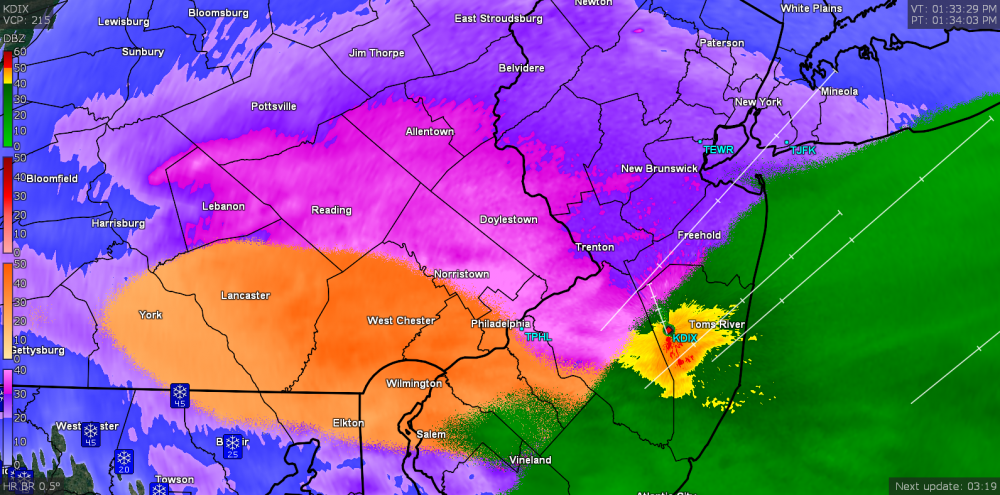
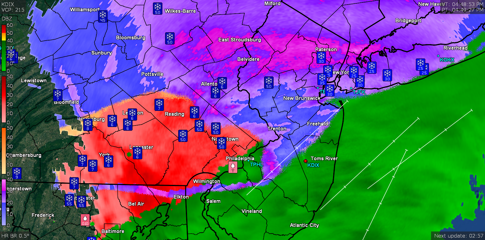
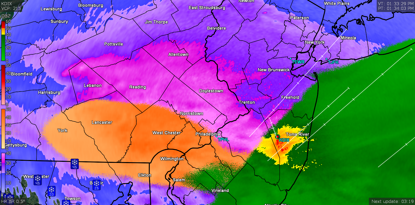
Looks like a dry slot is moving in from the SW. Still raining here and temp @ 33. -
1st Winter Event of 2018-19 Fall/Winter Season
Hurricane Agnes replied to ChescoWx's topic in Philadelphia Region
Now getting moderate rain. Temp has crept up to ~33 (32.5). -
1st Winter Event of 2018-19 Fall/Winter Season
Hurricane Agnes replied to ChescoWx's topic in Philadelphia Region
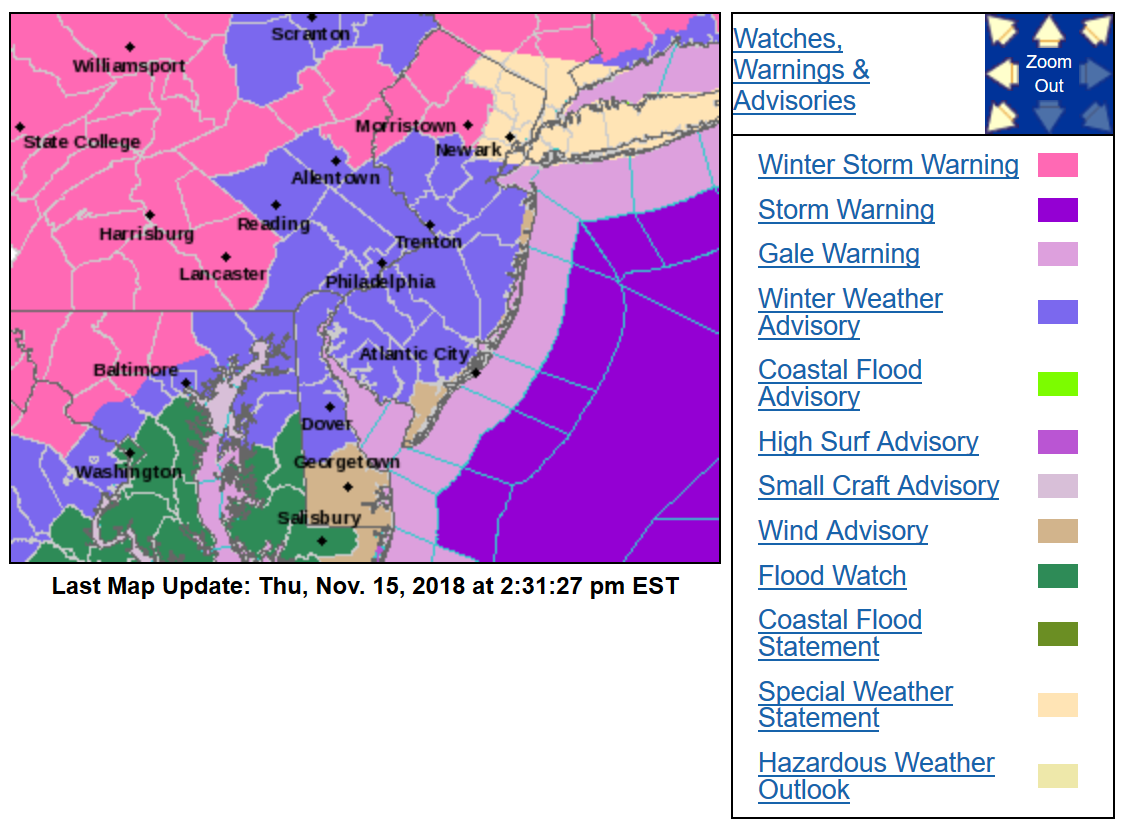
Temp is now just above 32 and the melting has begun. Now just plain light rain. Mt. Holly updated their WSW to include some of the portions of counties closer to the city (upper Bucks and Upper Montco) -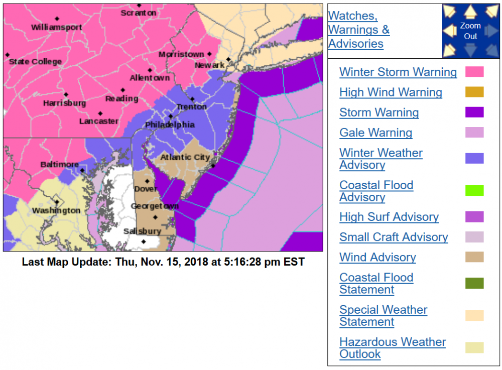
-
1st Winter Event of 2018-19 Fall/Winter Season
Hurricane Agnes replied to ChescoWx's topic in Philadelphia Region
The rain/snow line is also on the move from the SE. I'm guessing the high to the north is starting to move out. Temp here is just about 32 now (31.5). -
1st Winter Event of 2018-19 Fall/Winter Season
Hurricane Agnes replied to ChescoWx's topic in Philadelphia Region
I'm not even seeing one. This thing is juiced up. -
1st Winter Event of 2018-19 Fall/Winter Season
Hurricane Agnes replied to ChescoWx's topic in Philadelphia Region
Getting all light rain now which would be freezing on contact since the temp is 31. Will call it at 4.25" to include the final coating of sleet/snow. This was for sure about as a storm as you can get. Edit to add this -
-
1st Winter Event of 2018-19 Fall/Winter Season
Hurricane Agnes replied to ChescoWx's topic in Philadelphia Region
PNS so far (as of 3:53 pm ) - NOUS41 KPHI 152053 PNSPHI DEZ001>004-MDZ008-012-015-019-020-NJZ001-007>010-012>027-PAZ054-055- 060>062-067>071-160853- Public Information Statement Spotter Reports National Weather Service Mount Holly NJ 353 PM EST Thu Nov 15 2018 The following are unofficial observations taken during the past 13 hours for the storm that has been affecting our region. Appreciation is extended to highway departments, cooperative observers, Skywarn spotters and media for these reports. This summary also is available on our home page at weather.gov/phi ********************STORM TOTAL SNOWFALL******************** LOCATION STORM TOTAL TIME/DATE COMMENTS SNOWFALL OF /INCHES/ MEASUREMENT DELAWARE ...New Castle County... 2 S Newark 4.5 217 PM 11/15 CoCoRaHS Newark 4.3 201 PM 11/15 Trained Spotter Bear 4.0 249 PM 11/15 Trained Spotter New Castle County Ai 2.5 100 PM 11/15 ASOS MARYLAND ...Cecil County... Port Deposit 4.0 214 PM 11/15 Trained Spotter 5 NW Elkton 2.7 100 PM 11/15 CoCoRaHS North East 0.5 103 PM 11/15 Trained Spotter NEW JERSEY ...Atlantic County... Estell Manor 0.4 1125 AM 11/15 Snow and sleet. ...Burlington County... Mount Laurel 3.8 245 PM 11/15 NWS Employee Bordentown 3.5 309 PM 11/15 Social Media Westampton Twp 3.2 200 PM 11/15 Meteorologist 1 ESE Westampton Twp 1.8 100 PM 11/15 Official NWS Obs Presidential Lakes 1.5 212 PM 11/15 Social Media Hainesport Twp 1.4 118 PM 11/15 Meteorologist 1 SW Hainesport Twp 1.4 115 PM 11/15 In past 3 hours Mount Holly 0.1 151 PM 11/15 NWS Employee ...Camden County... 1 E Merchantville 4.5 311 PM 11/15 Trained Spotter Somerdale 3.3 315 PM 11/15 Co-Op Observer Lindenwold 3.2 229 PM 11/15 Trained Spotter ...Gloucester County... West Deptford 3.5 345 PM 11/15 Trained Spotter 2 S Wenonah 3.5 126 PM 11/15 Trained Spotter Mantua Twp 3.5 340 PM 11/15 Social Media Washington Twp 3.3 145 PM 11/15 Trained Spotter Mullica Hill 3.0 120 PM 11/15 Trained Spotter Newfield 2.8 128 PM 11/15 Snow changing to sleet. Pitman 1.6 155 PM 11/15 Trained Spotter East Greenwich Twp 0.7 103 PM 11/15 Emergency Manager ...Hunterdon County... Readington Twp 3.1 334 PM 11/15 Still snowing. 2 S Clinton Twp 1.8 245 PM 11/15 Trained Spotter 3 S East Amwell Twp 1.0 212 PM 11/15 In past 30 minutes. ...Mercer County... East Windsor Twp 1.5 319 PM 11/15 Broadcast Media ...Middlesex County... Woodbridge Twp 3.5 340 PM 11/15 Social Media New Brunswick 3.0 215 PM 11/15 Trained Spotter ...Monmouth County... 2 NNE West Freehold 3.2 300 PM 11/15 Trained Spotter Middletown 2.5 350 PM 11/15 Social Media Keyport 2.0 213 PM 11/15 Trained Spotter Matawan 2.0 234 PM 11/15 Social Media ...Salem County... Carneys Point 3.0 108 PM 11/15 Public Pennsville 2.0 120 PM 11/15 Trained Spotter ...Somerset County... Somerset 3.0 300 PM 11/15 Trained Spotter Bernardsville 2.1 342 PM 11/15 Trained Spotter ...Warren County... 2 NNE Greenwich Twp 2.9 309 PM 11/15 Trained Spotter PENNSYLVANIA ...Berks County... West Lawn 6.0 254 PM 11/15 Trained Spotter Shillington 4.0 213 PM 11/15 Social Media Hamburg 4.0 316 PM 11/15 Trained Spotter ...Bucks County... Morrisville 5.0 211 PM 11/15 Trained Spotter Bensalem 4.5 338 PM 11/15 Trained Spotter 1 NNW Langhorne 3.0 144 PM 11/15 Trained Spotter 1 WNW Plumstead Twp 2.5 221 PM 11/15 Social Media Hilltown Twp 2.0 200 PM 11/15 NWS Employee ...Chester County... Glenmoore 5.1 230 PM 11/15 Trained Spotter Malvern 5.0 245 PM 11/15 Trained Spotter East Nantmeal Twp 4.0 201 PM 11/15 Social Media Exton 3.7 121 PM 11/15 Trained Spotter 2 N East Marlborough 3.0 110 PM 11/15 Social Media Elverson 1.7 1217 PM 11/15 Social Media ...Delaware County... Chadds Ford Twp 4.7 215 PM 11/15 Trained Spotter 1 SE Thornbury Twp 4.0 149 PM 11/15 Trained Spotter Drexel Hill 1.5 1206 PM 11/15 Social Media ...Lehigh County... 1 S Allentown 4.5 300 PM 11/15 Trained Spotter North Whitehall Twp 4.1 330 PM 11/15 Meteorologist 2 NE Ancient Oaks 4.0 300 PM 11/15 Trained Spotter ...Montgomery County... 1 W Ambler 4.5 326 PM 11/15 Still snowing. 1 ESE Perkiomen Twp 4.5 300 PM 11/15 Trained Spotter Pottstown 4.0 234 PM 11/15 Social Media King Of Prussia 3.9 151 PM 11/15 Trained Spotter 1 SSW Narberth 3.8 130 PM 11/15 Trained Spotter 1 WSW Narberth 3.8 200 PM 11/15 Changed to sleet. Ambler 3.5 156 PM 11/15 Trained Spotter 1 NE Lower Providenc 3.3 222 PM 11/15 Trained Spotter ...Northampton County... North Catasauqua 3.6 315 PM 11/15 Meteorologist Bushkill Twp 2.0 300 PM 11/15 Trained Spotter ...Philadelphia County... Philadelphia 3.0 110 PM 11/15 Public 1 S Wissinoming 2.8 225 PM 11/15 Trained Spotter Philadelphia Intl Ai 2.4 100 PM 11/15 ASOS && -
1st Winter Event of 2018-19 Fall/Winter Season
Hurricane Agnes replied to ChescoWx's topic in Philadelphia Region
Yeah - much better. Traffic report is indicating mostly rain has moved into the city based on what they are seeing on the traffic cameras. -
1st Winter Event of 2018-19 Fall/Winter Season
Hurricane Agnes replied to ChescoWx's topic in Philadelphia Region
Getting mostly FZRA with some light snow mixed in. Temp has been slowly creeping up and now 30 (30.4). -
1st Winter Event of 2018-19 Fall/Winter Season
Hurricane Agnes replied to ChescoWx's topic in Philadelphia Region
Well I think most laughed at the model output from across the board showing 5" - 6" of snow in Philly metro (notably the GFS & NAM) so... -
1st Winter Event of 2018-19 Fall/Winter Season
Hurricane Agnes replied to ChescoWx's topic in Philadelphia Region
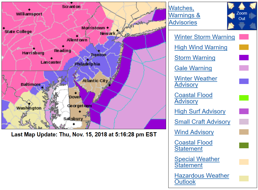
Looks like WSWs got expanded further north -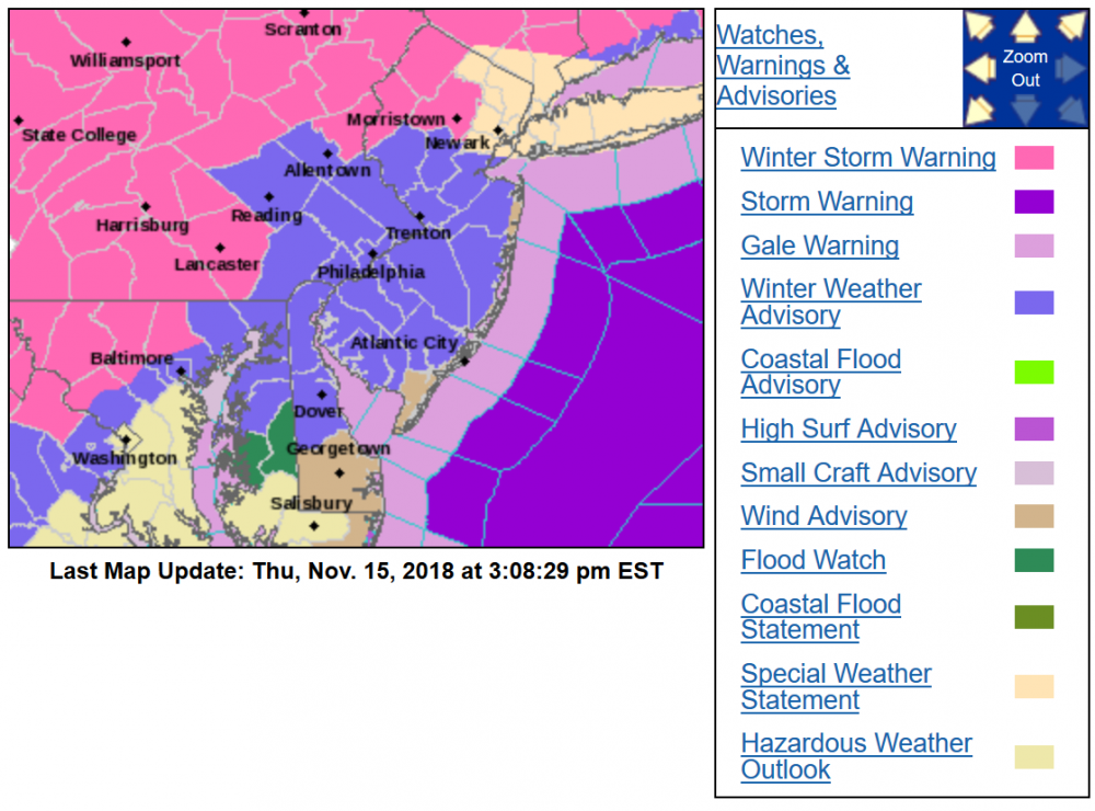
-
1st Winter Event of 2018-19 Fall/Winter Season
Hurricane Agnes replied to ChescoWx's topic in Philadelphia Region
Up to 4" of some layers/compacted measured on the board. Still a SN- mix with very light rain. Temp up to 30 (29.7) and slowly creeping up. -
1st Winter Event of 2018-19 Fall/Winter Season
Hurricane Agnes replied to ChescoWx's topic in Philadelphia Region
Currently SN- with a little white rain mixed in. Temp is 29. -
1st Winter Event of 2018-19 Fall/Winter Season
Hurricane Agnes replied to ChescoWx's topic in Philadelphia Region
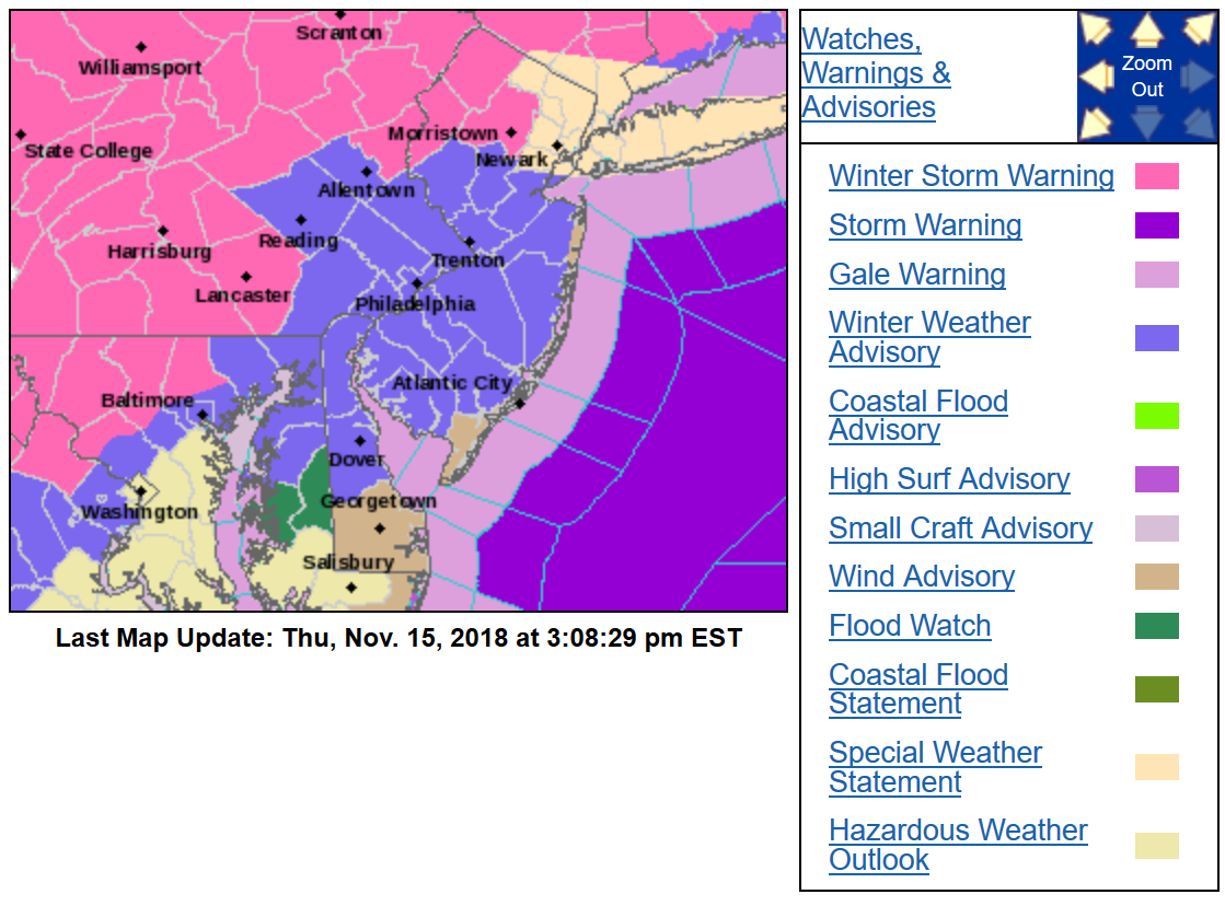
This is the latest that they issued -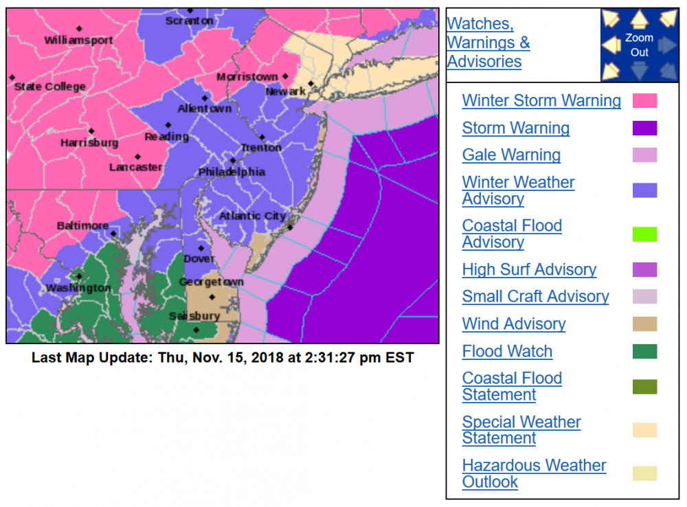
-
1st Winter Event of 2018-19 Fall/Winter Season
Hurricane Agnes replied to ChescoWx's topic in Philadelphia Region
They were tasty while they lasted. Now back to snow/FZRA mix. -
1st Winter Event of 2018-19 Fall/Winter Season
Hurricane Agnes replied to ChescoWx's topic in Philadelphia Region
Someone in Morrisville, Bucksco reporting 5". Looks like maybe lighter returns from the south -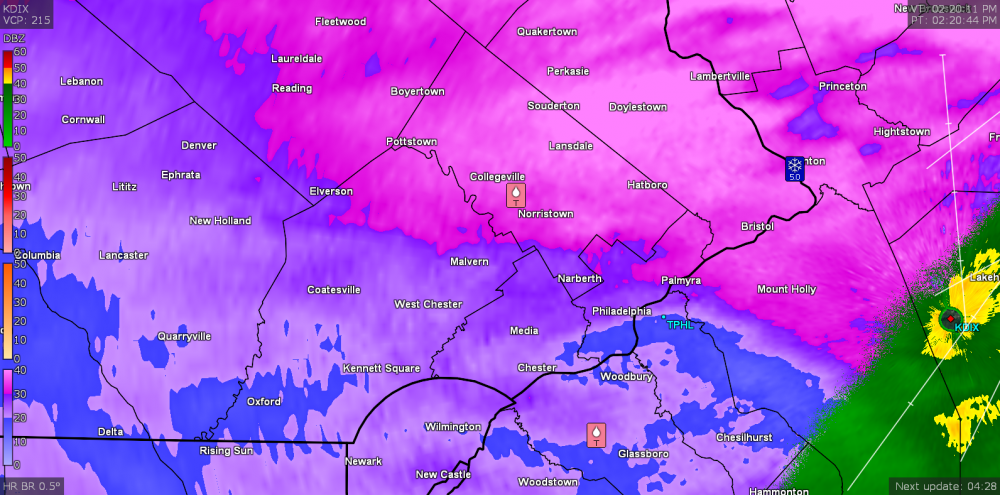
-
1st Winter Event of 2018-19 Fall/Winter Season
Hurricane Agnes replied to ChescoWx's topic in Philadelphia Region
SN+ with pancakes, near-omlette size flakes now. Temp is up to 29 (28.6). -
1st Winter Event of 2018-19 Fall/Winter Season
Hurricane Agnes replied to ChescoWx's topic in Philadelphia Region
Sleet line is moving quickly. Now getting a mix of snow/sleet/FZRA. Temp is up a couple tenths (27.9).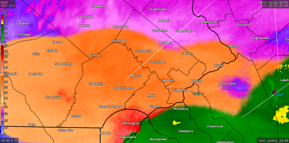
-
1st Winter Event of 2018-19 Fall/Winter Season
Hurricane Agnes replied to ChescoWx's topic in Philadelphia Region
All sleet now. Yikes! Ran out to measure a couple spots and it was up to about 3.25". Now it will start compacting with a layer of sleet. Temp is still 28 (27.7). -
1st Winter Event of 2018-19 Fall/Winter Season
Hurricane Agnes replied to ChescoWx's topic in Philadelphia Region
Spoke too soon. Just started sleeting. That moved in real quick. Can hear it up against the windows. Big flakes still mixed in though. -
1st Winter Event of 2018-19 Fall/Winter Season
Hurricane Agnes replied to ChescoWx's topic in Philadelphia Region
My sister in Delco (Upper Darby area) is reporting sleet mixing in with the bigger flakes. Not hearing any pings here in NW Philly yet.